|
MAMMOTH CAVE
Master Plan Preliminary Draft |

|
INTRODUCTION
PURPOSE OF THIS REPORT
The National Park Service is charged by the Congress (Act of May 25, 1926: 44 Stat. 635) with the responsibility to manage, develop, interpret, and preserve Mammoth Cave National Park "for the benefit and enjoyment of the people."
In recent years, increasing travel to the park, changing public needs, and studies required by the Wilderness Act have necessitated a complete review of the park's development and management.
This new master plan recognizes the relationship of the park to the surrounding region and provides for the continuing enjoyment of the park by the visiting public, yet preserves its basic values.
|
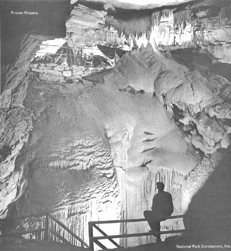
| Frozen Niagra. (National Park Concessions, Inc.) |
MANAGEMENT OBJECTIVES
The aim of management at Mammoth Cave National Park is to perpetuate the integrity and diversity of geologic features and life systems which are associated with the caves, aquatic and terrestial environments, for these have esthetic, recreational, educational, and scientific values to man. Solutions to the following problems will aid management in carrying out its obligations:
General Management
Select sites for development which will have the least deleterious effect upon the cave systems.
Provide solutions to management problems arising from the continuing increase in visitation.
Determine the disposition of the Job Corps facilities on Flint Ridge when that program is phased out.
Establish an orderly sequence of actions to aid management in carrying out the provisions of the master plan.
Resource Management
Identify those portions of the park which are suitable for designation as Research Natural Areas.
Restore, insofar as possible, natural water flows into cave passages on Flint Ridge.
Determine the scope of research required by management.
Design, build, maintain, and utilize all manmade improvements to minimize all concomitant polluting effects.
Visitor Use
Improve interpretation on the cave trips.
Develop new entrances to Mammoth Cave where feasible and practical and when warranted by increasing visitation.
Eliminate congestion in the vicinity of the Historic Entrance to Mammoth Cave.
Broaden interpretation to include geologic features, both inside and outside the park, which relate to a deeper understanding of and keener appreciation for the caves and their environment.
Provide for the public only those activities, facilities and services essential to visiting the caves and their related surface features so as to protect the unique cave systems in the southeast portion of the park.
Provide for facilities and services which are compatible with and will encourage wider use of the park's surface features along the river and to the north of the Green River.
Provide means for improving intrapark circulation.
Establish an environmental study area.
|
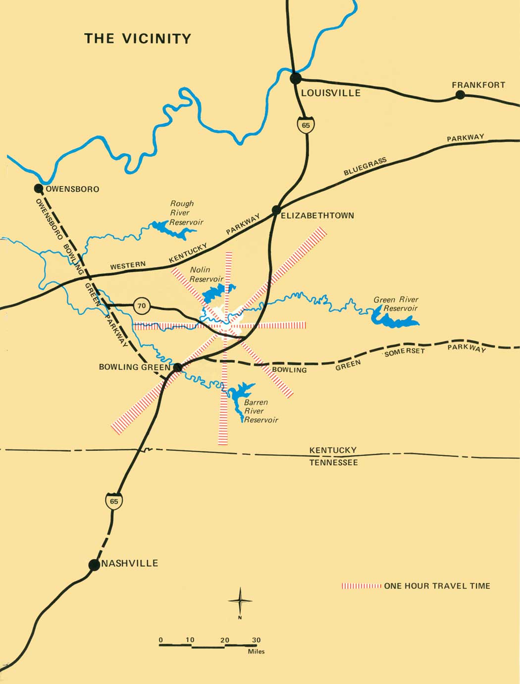
| The Vicinity. (click on image for an enlargement in a new window) |
SUMMARY OF THE PLAN
The Region
The "Cave Country" of south central Kentucky, which relied for years on agriculture, has now turned to light industry and tourism for its major income sources. Access to the region is primarily by way of the Louisville-Nashville corridor, a north-south route, containing two major highways and a railroad, all to the east of the park. Population and tourist accommodations have concentrated along this corridor. Interstate Highway 65, completed in this corridor in 1969, further stimulated construction of new motels, campgrounds, service stations, and other related tourist-oriented developments and services. Several State resort parks and summer homesites are being developed on the shore of reservoirs in the region. "Cave Country" is caught up in the general expansion of our outdoor recreation minded economy and this is causing sweeping changes in the region. Mammoth Cave continues to draw ever increasing numbers of visitors — an average increase of 30,000 per year over the past decade.
Improvement in transportation and increase in accommodations outside the park have drastically altered visitor patterns in the park. In the past, Mammoth Cave was a vacation destination; now 75% of the visitors remain in the park only four hours or less — long enough to enjoy a cave trip and relax while en route somewhere else.
Development of areas adjacent to the park can have profound effects on the park's resources. Particularly critical is the Sinkhole Plain to the south and east of the park. This 100,000-acre area is a natural "catchbasin" for rainfall which collects in underground streams, flows through natural conduits in limestone beneath the park and discharges into the Green River. Even minor changes in quantity or quality of this water could adversely affect unique aquatic life in these streams and could cause park caves to be closed. In 1944, the stream in Hidden River Cave in the town of Horse Cave near the park, became polluted by sewage; the cave has been closed to public tours ever since. The National Park Service solicits the aid of county and Commonwealth governments to ensure that the Sinkhole Plain remains in agriculture.
The Plan for The Park
In establishing Mammoth Cave National Park, the Congress noted three distinctive features of national significance:
Extensive limestone caverns and associated topography
Beautiful rivers
Rugged landscapes clothed in forests
The area containing these features was approximately 70,618 acres in extent and it offered "exceptional opportunity for developing a great national recreational park of outstanding service in the very heart of our Nation's densest population and at a time when the need is increasingly urgent and most inadequately provided for." These words are as applicable in 1970 as they were when they were written in 1926!
Today the park comprises only 51,354 acres purchased by a combination of private and public funds and donations.
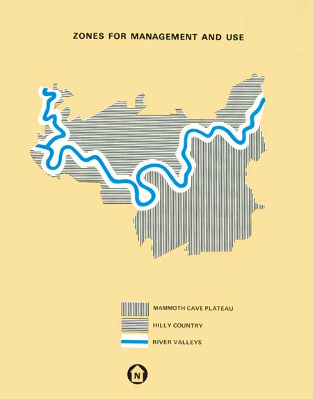
Based on the aforementioned features, the park has been divided for convenience of reference in this plan to three zones for management and use: the Mammoth Cave Plateau, the River Valleys and the Hilly Country.
Traditionally, the great majority of visitors have come to the park only to see Mammoth Cave. This has caused concentration of visitors and facilities on Mammoth Cave Ridge. An intolerable congestion of cars and visitors occurs at Historic Entrance throughout the summer season and on peak travel days in spring and fall. While this plan seeks to diversify park use so that visitors will have an opportunity to see more of the park, congestion will continue to increase at Historic Entrance unless a bold new scheme of visitor use is adopted.
This plan proposes relocating essential visitor facilities from Historic Entrance to a peripheral staging area where visitors' cars will be parked near an information-orientation center. From there a public conveyance will carry visitors to points of major interest. This will allow more people to visit the caves and related features and will improve the quality of the individual visitor's experience. This will also be accomplished by establishing the optimum number of persons participating in each cave trip and interpretation will be improved.
This plan also recognizes the need for cave-oriented research and exploration and suggests methods for implementing such a program. A cave zoning system is recommended to guide the management of subterranean resources.
Access to the Green and Nolin Rivers for boating, fishing, primitive camping, and for a sightseeing boat trip will be improved. Travel by hand-propelled or by low-powered, motor-propelled boats will provide rich experiences for observing and enjoying wildlife.
|
| Zones for Management and Use. |
The Hilly Country zone is west of Turnhold Bend and north of the Green River. There are no extensive cave systems beneath it, but it contains significant forest resources, fine scenery, and abundant opportunity for hiking and nature study. There are also excellent opportunities to observe and to teach some of the relationships between man and his environment. Several rare and relatively undisturbed ecosystems have been located which require special protection so their value as scientific reserves may be realized. Two small ferries cross the Green River in the park. They handle light traffic now, but they are inadequate for increasing traffic expected in the near future.
To make the Hilly Country more accessible and to facilitate required cross park traffic, it is recommended that a bridge be built across the Green River to connect State Rt. 70 with the Houchins Ferry Road.
From this roadway, access could be provided by foot or by horseback to scenic attractions like Bylew Creek, Whistle Mountain, Nolin River, and First Creek Lake. The existing Houchins Ferry Road would remain for access to picnic and boat launching facilities on the river banks. The ferry might continue as a bit of "living history."
Fulfillment of this plan will require more than a decade to carry out. Then the visitor to Mammoth Cave National Park will be able to use and enjoy its natural resources more fully than ever before. While Mammoth Cave will continue to receive the greatest intensity of visitor use, other cave systems offer resources for important scientific research. In turn, the irreplaceable and unique resources of the cave systems will receive better protection. The plan also provides opportunities for visitors to become better acquainted with the scenery of the river valleys and the northern portion of the park.
| <<< Previous | <<< Contents>>> | Next >>> |
maca/master_plan/intro.htm
Last Updated: 15-May-2007