|
Mojave
From Neglected Space To Protected Place: An Administrative History of Mojave National Preserve |

|
CHAPTER TWO:
PRELUDE TO SYSTEMATIC FEDERAL MANAGEMENT
The history of the eastern Mojave prior to systematic federal management is long and varied. Most of the challenges and opportunities faced by Mojave National Preserve have their roots in the history of human habitation of the area. Likewise, many of the outstanding resources and attractions, as well as the less attractive features of the park, are the result of human efforts. As such, understanding the history of the eastern Mojave before systematic federal management is crucial to understanding the area afterward.
Individual perceptions of the eastern Mojave varied by cultural affiliation and the individual's potential for economic gain from the area. Native Americans such as the Chemehuevi and the Mohave understood the area as a homeland and a transportation corridor. Early Europeans and Euro-Americans viewed the desert as an unremittingly hostile place. Ranchers and miners envisioned economic opportunity through resource extraction, while homesteaders imagined land ownership and yeoman freedom. Beginning in the nineteenth century and continuing throughout the following century, railroads, power and pipeline companies, and migrants on Route 66 alike saw, in John Steinbeck's words, a place that one must "get acrost." The U.S. Army looked at the Mojave as a facsimile of North Africa, suitable for training, and Americans after World War II understood it as recreational space. The first threads of systematic management could be found in the post-Taylor Grazing Act (1934) ranching operations, but comprehensive federal control did not happen until widespread, destructive recreation forced the government to take action in the 1960s.
Native Americans and Anglo Contact
|
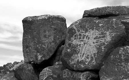
| Illustration 2 - Prehistoric petroglyphs, like these at Indian Well, are found at sites scattered throughout Mojave National Preserve. (Photo by Eric Nystrom, 2001.) |
About 11,000 years ago, the region's ecological zones were one thousand feet lower in elevation than today due to the cooler and wetter weather patterns of the waning Ice Age. Streams flowed and lakes existed where dry playas are today. The relative abundance of plant communities supported wildlife and indigenous peoples who depended upon the natural resources. While clear archaeological evidence of human presence in this early time are sparse, over 1,300 later prehistoric and historic period archaeological resources have been recorded for the large Preserve area, including 65 rock image sites. Museums and professional researchers have made significant collections of artifacts since 1925.
In general, these tribal peoples occupied the lands as small, mobile social units of related families who traveled in regular patterns and established summer or winter camps in customary places where water and food resources were available. Archaeologists named a series of five manifestations of Native American occupation, which were believed to describe changes in climate, chipped stone technology, and subsistence practices of these early peoples. These periods covered time intervals from about 5000 BC to AD 700-900. At that point, the Mojave desert area, unlike other portions of California's desert region, was influenced by native peoples now called 'Ancestral Pueblo' who established farming villages along the Muddy, Virgin, and upper Colorado rivers. Their culture reached into today's Preserve lands at turquoise sources and via trade trails as far as the Pacific coasts. Later, however, Ancestral Pueblo peoples abandoned their territory and were replaced by Shoshonean and Paiute peoples after about AD 1000. In addition, native peoples of the lower Colorado River basin speaking Yuman languages expanded their river zone territory and utilized some desert lands as well.
Modern Native American "tribes" were products of interactions with the American military and legal system as much as modern reflections of pre-contact Native American land use patterns, and the land allocated to these groups frequently did not reflect the actual extent of their pre-Anglo homelands. No tribes directly control any lands in the Preserve, but historical, archaeological, and ethnographic information indicates that ancestors of the modern Chemehuevi and Mohave Tribes traveled, camped, hunted, and resided at various places now in the Preserve. Oral traditions and historical information compiled into maps for the 1950-1960s Federal Indian Lands Claims cases showed Chemehuevi land knowledge and uses. Some Mohave Tribal members have family histories of being on lands now within the eastern areas of the Preserve. Certainly, the very detailed and lengthy "song cycles" of the Chemehuevi identify many places within the Preserve with names and events of supernaturals who performed various activities there. The "song cycles" were a type of oral map of the territory which had great value to travelers moving through the area or following seasonal foraging patterns. However, both tribal groups sustained hostilities between themselves, which was noted by Spanish Friar Francisco Garcés in 1776. Euro-American contact with peoples now called Chemehuevi or Mohave increased in the nineteenth century. [1]
The Desert Chemehuevi were Native Americans who actually lived most of the year in the area of the Preserve. Limited food and water resources sustained a low Desert Chemehuevi population density. When food was abundant, it would be dried and cached for later use. The area of the Preserve probably never supported more than about 150 people at any one time. [2]
While the Chemehuevi were the primary inhabitants of the area now encompassed by the Preserve, the desert and the park itself are named for a different group of Native Americans - the Mohave. [3] The Mohave were agriculturalists who planted in the flooded plain of the Colorado River. This agricultural lifestyle generated food surpluses, which enabled them to support a sizable population in the river basin area, numbering in the thousands. The Mohave frequently traded with other Native American groups to the west and east, and had a particular fondness for seashells traded by Indians on the California coast. The Mohave had a network of trails across the desert from waterhole to waterhole. The Mohave bragged to early European visitors that a powerful Mohave runner could make the trip to the Pacific coast, more than 150 miles long, in three days. The Mohave guided some of the first non-Indian travelers over this network of trails, including friar Garcés in 1776 and American trapper Jedediah Smith in 1826. Their network of trails, now known as the Mojave Road, became one of the main routes used by the government and other travelers to cross the desert before the advent of the railroad.
The Mohave were friendly to Garcés and Smith at first, but when Smith returned to recross the river in 1827, the Mohaves attacked as his party was crossing. Historians later determined that other trappers, arriving between Smith's two visits, killed several Mohaves and antagonized the rest, prompting the tribe to exact revenge on the next Euro-Americans they saw. Half of Smith's party was killed, and the explorer led the survivors back across the desert trails to relative safety in California. This incident created the reputation of the Mohaves as a fierce band that should be avoided. [4] Further encounters with trappers in the late 1820s and early 1830s led to more bloodshed by Indian and Anglo alike. Historians hypothesize that the Old Spanish Trail, which runs to the north of the Preserve, was created in the 1830s specifically to bypass the Mohave. [5]
In 1848, the United States signed the Treaty of Guadalupe Hidalgo to end the Mexican War and received almost all of the territory that is now the American Southwest, including all of California and all of the area of the Mojave National Preserve. Interest in building a transcontinental railroad was high, but the choice of route was difficult due to sectional controversies. In 1853-54, the United States sent several survey teams into the field to report on the feasibility of the various routes. One of these was the so-called 35th Parallel Route, which cut through the eastern Mojave. Two survey parties took the field: one, under Lt. Robert S. Williamson, explored from the western side and proceeded as far as Soda Lake; the other, under Lt. A.W. Whipple, proceeded from Arkansas to Los Angeles, crossing the Preserve along the route of the Mojave Road. [6]
Later attempts proved more successful at opening the cross-desert route now known as the Mojave Road. Between 1855 and 1857, the General Land Office surveyed township lines throughout the area. This effort was largely wasted when the location monuments could not be rediscovered by others, but the small number of people on the surveying teams became very familiar with the desert and later served as guides for other expeditions. In 1857, Edward F. Beale surveyed a wagon road across the Arizona desert, and crossed the Mojave along the route of the future Mojave Road. Combined with his eastbound crossing in 1858, Beale's success proved the viability of the wagon road.
Conflict between Native Americans and Euro-Americans was the catalyst for the establishment of a lasting federal legacy in the Mojave desert. The Mohave attacked emigrant wagon trains in 1858, prompting a substantial military response. [7] Major William Hoffman led a unit of over 600 men to the Colorado River, homeland of the Mohave, and demanded surrender. Prudently, the Mohave complied, and Hoffman set up a military post on the eastern bank of the Colorado River that soon became known as Fort Mojave. The effort to supply the fort caused wagon teams from Los Angeles to cross the eastern Mojave regularly until the start of the Civil War in 1861, and turned Beale's path into a true wagon road, easily followed. Some improvements were made to the route at this time, such as the construction of a water stop known as Government Holes.
The U.S. military spent several months in the eastern Mojave in an ill-conceived attempt to punish Native Americans for a crime they may not have committed. In 1860, two whites were murdered at Bitter Springs, on the Salt Lake Trail, and the attacks were blamed on the "Pah-Utes," though contemporaries and later historians suggested that the attacks were quite possibly carried out by Mormons, rather than Native Americans. Newspapers in southern California whipped the citizenry into a fury, and prompted the army to send a unit led by James H. Carleton, an Army dragoon from Fort Tejon, California, into the desert to exact revenge on the Native Americans supposedly responsible for the attacks. Carleton's troops built a small fort at Camp Cady, and roamed all over the western portion of the present-day Preserve - through Devil's Playground, around the Granite Mountains, and across Soda Lake. The soldiers constructed a small earthen fortification, called Hancock's Redoubt, at Soda Springs. Carleton chased his quarry all over the desert, and executed several in an attempt to impress the remainder with the power of the United States military. At the end of his three-month stay in the desert, the Native American leaders arrived at Camp Cady and asked for peace. Carleton negotiated a cease-fire, but it was ultimately ineffectual as the army did not return later (due to the Civil War) to distribute aid as promised and uphold their end of the bargain. [8]
The Civil War prompted the military to abandon Fort Mojave in 1861. In mid-1863, it was re-activated with a garrison composed of California Volunteers, to provide security for travelers to Arizona. Gold was discovered in Arizona that year and by 1864, the Mojave Road was a crucial supply line to the territorial capital at Prescott. From 1866 to 1868, the mail was carried over the Mojave Road from California to Arizona. Native Americans in the Mojave and in Arizona commenced hostilities, and a group attacked the garrison at Camp Cady. This emphasized the importance of having a military escort for the mail as it crossed the desert. To support this escort effort, the military constructed small outposts at Soda Springs, Marl Springs, Rock Spring, and "Piute" Creek. The army successfully negotiated an end to the conflict in late 1867. Shortly thereafter, a series of heavy rainstorms left the road impassible. This factor, combined with the cumulative losses to Native Americans along the Mojave route, caused the transfer of mail service to a different, more southerly trail. The outposts at Piute Creek, Rock Spring, Marl Springs, and Soda Springs were abandoned. [9]
Military use of the Mojave Road diminished, but civilian use increased as more people were attracted to the desert area. By the 1870s, Fort Mojave was largely supplied by steamboat service up the Colorado River, but miners, prospectors, and ranchers used the Mojave Road to cross the desert until the Southern Pacific / Atlantic & Pacific Railroad was completed in 1883. [10]
Grazing
Grazing of non-native livestock has occurred on most of the land that is now the Mojave National Preserve at one time or another over the past 150 years. Livestock was present in the east Mojave in association with the earliest Euro-American uses of the desert. Travelers over the Mojave Road almost always had some stock with them, and grazed them as they crossed the desert. Several times, herds of hundreds of cattle or sheep were driven over the route across the Mojave either to resupply Fort Mojave on the Colorado River or to move livestock to fresh range in New Mexico and Arizona. Military outposts constructed along the Mojave Road conducted small-scale grazing activity, to supplement the soldiers' food supply. [11]
Entrepreneurs took advantage of the open range and ready market in the form of miners and later railroad workers by setting up several ranches in the years from about 1875 to the end of the nineteenth century. George Briggs and LeRoy Blackburn, two of the future partners of the Rock Springs Land & Cattle Company, set up their individual ranches around 1875, with headquarters at Marl Springs and Government Holes, respectively. John Domingo raised work horses on a ranch near the Bonanza King mine starting in the early 1880s, and Daniel Kistler raised beef for sale near what is now known as Kessler Spring at about the same time. [12]
In 1894 Blackburn and Briggs, along with other investors, merged their holdings to form the Rock Springs Land & Cattle Company, with headquarters at Barnwell, the northern terminus of the newly constructed Nevada Southern Railway. This move highlighted the fact that while local consumption by miners in the area was important to the firm, so too was the capability to transport cattle to other markets via the railroad. The Rock Springs outfit, like other ranchers in the area, grazed their cattle on public land without fences. They moved aggressively to purchase or trade for ownership of water rights, the possession of which enabled de facto control of the surrounding range. At various times, the company had more than 10,000 cattle on their fifty square mile range. [13] The company came into conflict with homesteaders who staked claims in prime grazing territory after 1910. Cattle trampled homesteaders' crops (sometimes at the deliberate urging of the cowboys) and the company denied homesteaders access to water; homesteaders retaliated by helping themselves to free beef. A shootout at Government Holes in 1925 was the final straw for many of the homesteaders who had not yet left. [14]
Sidney E. "Boots" Yates arrived in the Valley Wells area in 1894, alone with 27 head of cattle, and set up a ranch of his own. With hard work, good forage years, and a job as foreman of the Rock Springs Company that provided a steady income, Yates worked steadily and built up his ranch. After World War I, Yates started his nephew, L. E. "Boy" Williams, in the cattle business as well. Yates passed away in 1923 and his widow Bessie continued to run the Valley Wells ranch. [15]
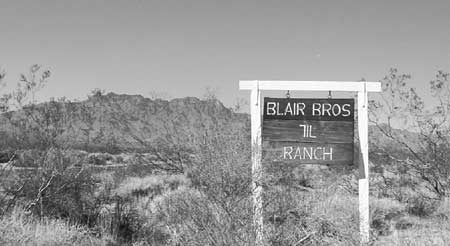
John Domingo raised horses on his ranch near Providence until 1918, when he sold his holdings. The ranch soon came under control of the partnership of J. N. Sanders and W. W. "Wash" Gibson, who stocked the ranch with cattle and called it the 7IL. Sanders and Gibson hired Frank Murphy, a homesteader from the Lanfair area, to direct the day-to-day operations in the early 1920s.
|
| Illustration 3 - The 7IL Ranch, in the Colton Hills area, has been operated by members of the same family since 1938. (Photo by Eric Nystrom, 2001.) |
A massive drought in the late 1920s, culminating in 1928, contributed to changes on the Mojave range. The Rock Springs Land & Cattle Company dissolved under the pressure. Most of the cattle had perished on the range, but the remainder were rounded up and sold in urban markets. In September 1928, the northern part of the Rock Springs range was sold to Bessie Yates and "Boy" Williams. The Rock Springs lands in Nevada were given to long-time ranch superintendent John Woolf, who promptly sold the property to Hollywood western movie star Rex Bell, who together with his wife Clara Bow, lived and worked on the ranch they called the Walking Box. In September 1931, the remainder of the Rock Springs Land & Cattle Company's holdings were sold to a group headed by Claud Halsell, Sr., who took complete control within a year of the ranch they called the OX. [16] Additionally, Gibson and Sanders sold the 7IL Ranch to Mark and Mary Pettit in 1929.
The late 1920s and 1930s were years of flux in the cattle business in the east Mojave, not only because of the substantial drought, but also due to the passage of the Taylor Grazing Act in 1934. The Taylor Grazing Act compelled individual ranchers to clearly delineate and fence their ranges, and required grazers to pay fees to the government for forage consumed by each animal on public lands. Mark and Mary Pettit sold the 7IL that year, just prior to the signing of the act, in part because of concerns over impending government regulations. The ranch was sold again in 1938 to Herbert and Anson Murphy, sons of Frank Murphy who had operated the ranch in the early 1920s. [17] The Yates/Williams partnership that purchased part of the Rock Springs range dissolved in 1937 as a result of the need for smaller holdings that could be fenced, resulting in the creation of the Kessler Springs Ranch for Williams and the Valley View Ranch for Yates. The Valley View was sold to Fred Twisselman in 1940, while the Valley Wells ranch remained in the hands of Sarah Yates Miles, daughter of "Boots" Yates, and her husband, Wade Miles. Fleetwood "Fleet" Southcott Sr. came to the Gold Valley area in 1931, after losing his fortune in the Great Depression, and staked a homestead in Gold Valley with an eye toward developing a ranch. [18]
The Taylor Grazing Act caused changes in the ranching landscape in the Mojave, by requiring ranchers to fence their ranges and develop multiple water sources, so that the burden on any one part of the range was lessened. "Boy" Williams and Claud Halsell both constructed large numbers of corrals, improved water sources, and built many miles of fence to bring their Kessler Springs and OX Ranches into compliance. "Fleet" Southcott saw the act as an opportunity to develop a ranch of his own, and leased an allotment in the Gold Valley area before Halsell was able to do so. [19]
During the years from the 1940s to the passage of the California Desert Protection Act in 1994, ranching in the area evolved, but remained rooted in old-fashioned methods that worked better on the tough range than modern agribusiness techniques. "Slim" Skinner and his father-in-law, Fred Twisselman, bought the Valley View from Bessie Yates in 1940. Unlike many of the "cow and calf" operations in the desert, such as the OX and Kessler Springs ranches, the Valley View was worked as a steer operation, involving greater risk, but potentially greater profit. Skinner retired in the early 1980s and sold the ranch to Andy Anderson of Montana. [20] In 1960 the Murphy brothers sold the 7IL ranch to their nephews, Howard and Jerry Blair, the descendants of whom still own and operate the ranch. [21] "Boy" Williams sold the Kessler Springs Ranch in 1942, and it passed through the hands of several often-absentee owners until it fell under control of part-owner Gary Overson in 1969. Overson was raised in the east Mojave, first working for the OX Ranch at eleven years of age. Through hard work and a shrewd sense for expansion, he bought out his partners at Kessler Springs within a decade.
Claud Halsell retained ownership of the OX Ranch until 1946, during which time he added a tremendous number of improvements, fenced most of the range, added private lands to the ranch holdings, and moved the ranch headquarters from Barnwell to Ledge, along Lanfair Road. Halsell's successors, the partnership of Waldo Bozarth and Oscar Rudnick, owned the ranch until 1955 and built a herd from 1,000 to 5,000 animals during that time. Ed Eldridge purchased the ranch from Bozarth and Rudnick, and constructed a large number of fences, corrals, and pipelines to facilitate expansion of his ranching operation. When Eldridge was ready to retire, he sold the OX to Gary and Linda Overson in 1986, giving the Oversons direct control over most of the Mojave range. Later, the Oversons also managed the Valley View and Valley Wells ranches for Richard Blincoe, an Idaho-based agricultural businessman. [22]
The lands of the east Mojave have been subject to ranching for profit for more than 125 years, and in that time have indelibly changed. The key to ranching in the Mojave is water, and commercial ranches have developed extensive water systems which are also used by wildlife. Though no definitive data exists, the numbers of both native and non-native species may have been enhanced by the long-term availability of these water sources, making it difficult to discover what pre-ranching levels of wildlife were like. In the same way, long-term ranching has quite possibly been responsible for the creation of some of the Preserve's most magnificent landscapes, the Joshua tree forests of Cima Dome and Lanfair Valley. Biologist Harold Avery noted that cattle grazing in the Mojave had the effect of increasing the number of shrubs, and biologist Steve Brittingham noted that shrubs provide microclimates that nurture the development of Joshua trees. [23] Jim Cornett, a biologist with the San Bernardino County Museum, also explained the connection between cattle grazing and increased Joshua tree density as a product of the shelter that unpalatable shrubs give to the infant trees. [24] An analogy, focused on the role of subtle human effects in producing landscapes that are seemingly "natural," can be drawn between Mojave's Joshua tree forests and the forests of giant sequoias in Sequoia National Park, where researchers in the 1970s realized that the huge trees were largely the product of the Native American practice of setting deliberate fires. Both the sequoias and Mojave's Joshua tree forests are beautiful attractions, seemingly natural, that were in reality partially formed by human actions over a long period of time. [25] In the cultural history of the eastern Mojave and in the landscape itself, the continuous presence of cattle grazing in Mojave National Preserve has left an important legacy.
Mining
Mining activity played an important role in the history of the area that is now Mojave National Preserve. Geologists agree that mineralization is often associated with faults, joints in rock that allow mineralized water from inside the earth to flow toward the surface, where the water evaporates and leaves the dissolved minerals behind. The Mojave has been categorized as extremely geologically active, a consequence of its position at the junction of two of earth's crustal plates. This faulting and other geologic activity left the desert a highly mineralized area, with large varieties of precious metals and industrial minerals scattered in small deposits of rich ore. A truly remarkable amount and variety of minerals have been removed from the area of the Preserve, including gold, silver, lead, zinc, copper, tungsten, vanadium, iron, clay, and cinders. Discovery, exploration, and development of the area's rich mineral potential was facilitated by the lack of vegetation, which tended to obscure mineral deposits in more temperate locations. Most mines in the Mojave, particularly precious metal mines, offered small veins of rich ore, which led to occasional bonanza strikes but little long-term profitability. Nevertheless, mining activity was a consistent theme throughout the history of human use of the eastern Mojave desert.
Mining by Americans began in the 1860s, although many discoveries did not develop for several decades until the costs of production and transportation were reduced by the railroad. Before the arrival of Euro-Americans in the area, Puebloan people mined for turquoise at several sites near the boundaries of the Preserve, and persistent traditions of Spanish and/or Mexican mining activity tantalized early American miners. [26] Some of the soldiers stationed at the remote outposts along the Mojave Road, especially in the vicinity of Marl Springs, are thought to have conducted small-scale exploration in 1860. [27] The following year, gold was discovered in the Vanderbilt area, but thirty years passed before this deposit was developed. In 1863, prospectors discovered silver and subsequently formed the Rock Springs Mining District, also known as the Macedonian Mining District. The intense isolation of the area made profitable excavation almost impossible, and troubles with Native Americans caused its abandonment by 1866. [28]
The first significant mining activity in the present-day Preserve began in the mid-1860s, and profitably produced silver for more than a decade despite difficulties caused by geographic isolation. In 1865, prospectors discovered silver on the north side of Clark Mountain, and organized the Clarke Mining District that July. [29] The mountain was named after the district, itself labeled in honor of William H. Clarke of Visalia, California, owner of a popular saloon. [30] Ivanpah (later called Old Ivanpah) was the main town, located in the heart of the Clark District on the north side of Clark Mountain. The area, described by one modern author as "the most important [mineral area] ... of all of San Bernardino County," produced a considerable amount of silver between 1869 and 1880, when profits began to decline and people moved away. The district hung on until the late 1890s, when a crash in the price of silver ended mining there. The extraordinary remoteness of the area caused profitability problems as well. [31]
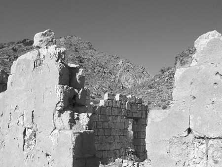
The other major mine before the turn of the twentieth century was the Bonanza King Mine, located near the present 7IL Ranch. Discovered in 1880 by Ivanpah prospectors, the Bonanza King produced rich silver ore until 1885, and sporadically thereafter. The mill, believed to have been near the current 7IL Ranch headquarters, burned in 1885 and was not immediately rebuilt. Later owners revived the mine several times, most significantly between 1905-07 and 1915-1920. Bonanza King workers lived near the mine in the town of Providence, where stone ruins still stand. The profitability of the mine was helped by the construction of the Atlantic & Pacific Railroad to the south; Bonanza King stock was listed on the New York Stock Exchange, and output eventually totaled more than one and a half million dollars. [32]
|
| Illustration 4 - Stone walls mark the location of 1880s-era Providence, near the Bonanza King Mine. (Photo by Eric Nystrom, 2001.) |
Railroads helped stimulate mining in the Mojave. The Atlantic & Pacific was completed in 1883, but had little effect on the Ivanpah mines, which were already in decline. Beginning in 1893, the Nevada Southern Railway, built north from Goffs to Barnwell, tapped the Vanderbilt area, the Sagamore Mine, and other potentially profitable ventures, and helped stimulate prospecting and small-scale mining in the area. Just after the turn of the century, that railroad extended branches from Barnwell through the New York Mountains to the Ivanpah Valley, as well as to Searchlight, both of which coincided with additional mining activity. [33]
The "Great Years" of mining in the eastern Mojave, so named because adequate capital financed substantial production of both precious metals and industrial metals, came between 1900 and the end of World War I. In 1900, a boom at Tonopah, Nevada, sent prospectors throughout the desert region, and a large number of claims were staked in the Mojave. Several Mojave mines were big producers. The Copper World, in the Clark Mountain section of the Preserve, produced 100 tons each day, making it one of the larger copper mines in California at the time. The Von Trigger Mine, later known as the California Mine, produced 30,000 tons of copper between 1907 and 1909. The Paymaster Mine, discovered in 1900 on the slope of Old Dad Mountain, produced some $75,000 worth of gold between 1910 and 1914. These small bonanzas were short-lived. The depression that followed World War I caused substantial contraction of mining nationwide; smaller producers like those in the Mojave simply found it impossible to operate economically. [34]
The Great Depression sparked an increase in gold mining in what later became the Mojave National Preserve. The Depression caused an increase in the price of gold, and labor expenses were low. These factors, combined with another key ingredient, described by one author as "men not having much else to do," caused a surge of gold mining activity in the area. The Colosseum Mine, discovered as early as 1880 but never mined comprehensively, began substantial production in 1929, and the Telegraph Mine, first located in 1930, produced $100,000 in gold between 1932 and 1938. [35]
The entrance of the United States into World War II in late 1941 prompted a change in mining activity in the eastern Mojave, accelerating a shift from production of precious metals to excavation of industrial minerals. During World War II, mining of almost all precious metals was halted by executive order to free resources for America's war effort. Some resources made more valuable by the war were found in the eastern Mojave, including copper from several small mines, and tin and tungsten from the Evening Star Mine. The most important wartime production came from the Vulcan Mine in the Providence Mountains, which supplied iron ore for the blast furnaces of Henry Kaiser's Fontana steel mill and turned Kelso into a boom town of 1,500 people. [36]
After the shutdown of the Vulcan Mine in 1948, much of the remaining mining activity in the eastern Mojave focused on salable materials such as cinders. [37] The Aiken Cinder Mine and the Cima Cinder Mine both began operation around 1948, and profitably worked their deposits through the 1990s. The primary exception to the focus on salable minerals was the Mountain Pass Mine, located just outside Preserve boundaries, which was purchased by Molybdenum Corporation of America (Molycorp) in 1951 and remains one of the largest producers of rare earth elements in the world. [38]
The period between the late 1970s and mid-1990s saw a worldwide revolution in gold mining methods. The development of cyanide heap leaching, first proposed to the mining community by the Bureau of Mines in 1969, enabled miners to recover microscopic amounts of gold. [39] This was merely an interesting tool until the price of gold, which had been regulated until the 1970s, was allowed to follow the market. The value of gold skyrocketed, which prompted demand for new sources of the metal. Cyanide heap leach technology permitted companies to extract gold from the tailings left behind at older mines. The new technique also permitted companies to profitably extract gold from mines that had not previously had concentrations of ore rich enough to mine. Three major mines in and around Mojave National Preserve were opened or re-opened using cyanide heap-leaching: the Colosseum Mine and the Morning Star Mine were both located inside the boundaries of the Preserve, and Viceroy Gold's Castle Mountain Mine was specifically excluded from the park in the passage of the California Desert Protection Act. Neither of the open pits inside the park were actively mined after the establishment of the Preserve, but these mines have left behind enormous piles of tailings with residual cyanide, as well as the open pits themselves.
Railroads
Railroads transformed the United States throughout the nineteenth century, prompting development of industry throughout the country and providing conduits for development along their lines. The Mojave desert was in the path for one of the earliest potential locations for the transcontinental railroad, the so-called "35th Parallel Route" or southern route explored by Lieutenant A.W. Whipple in 1854. If chosen for the transcontinental railroad, the 35th Parallel Route would have placed the railroad through the South and given an economic boost to the slave-owning states of pre-Civil War America. Ultimately, the decision of which of three routes to choose for a railroad to the Pacific was shelved because of sectional politics, but within half a century the eastern Mojave desert was crossed by two transcontinental railroads as well as a regional line.
Desert geography and competition between railroad companies dictated placement of the first railroad south of the cross-desert Mojave Road. In most parts of the United States, railroads generally followed existing routes of travel, since they were usually the paths of least geographical resistance, and A.W. Whipple followed the Mojave Road in his 1854 explorations. In the desert, the steepness of the terrain was of less concern to early travelers than the availability of water. As a consequence, the Mojave Road, like the Indian trails it overlaid, traveled through mountain ranges rather than around them. This feature made the track of the Mojave Road unsuitable for railroad use and created another pattern of transportation across the eastern desert. A more moderately graded route was located in 1868 by General William J. Palmer, working for the Union Pacific Railway, Eastern Division. [40] That railroad was never built, but the Southern Pacific constructed a line through the desert in 1882-83, from Mojave to Needles, largely along Palmer's route. This road was built to forestall competition from the Atlantic and Pacific Railroad (A&P), which was controlled by the Atchison, Topeka, and Santa Fe Railway, more casually known as the Santa Fe. The A&P reached the eastern bank of the Colorado River in May 1883, and the lines were connected three months later, but the Southern Pacific's control of the track through the Mojave precluded its usefulness to the A&P. In 1884, after the Santa Fe threatened to build a line parallel to the Southern Pacific's route in order to allow traffic to pass, the latter railroad sold its desert trackage to the A&P. Although the Santa Fe held control of the A&P since before its construction through the Mojave, the A&P name was used along the line until 1897. Today the line, run by the Burlington Northern and Santa Fe Railway, forms much of the park's southern boundary. [41]
In addition to the trans-desert route of the Santa Fe, entrepreneurs constructed shorter railroads to directly service settlements in the eastern Mojave. In 1893, the Nevada Southern Railway was constructed north from Goffs to Manvel, later known as Barnwell, to tap into the mining districts of Southeastern California and Southern Nevada. It promptly went bankrupt, and was reorganized in 1895 as the California Eastern Railway. Six years later, the line was extended into the Ivanpah Valley, and in 1902 was taken over by the Santa Fe Railway. Four years later, the Barnwell and Searchlight Railway was built from Barnwell to the mines at Searchlight, Nevada. After 1918, the Santa Fe abandoned part of its line in the Ivanpah Valley and only ran trains past Barnwell as demand warranted. Several substantial washouts, combined with the unprofitability of the lines, caused the Santa Fe to abandon all of its lines north of Goffs in 1923. [42] Lanfair/Ivanpah Road parallels the former Nevada Southern Railway grade as it proceeds northward from Goffs, then runs directly upon it for part of the distance through the New York Mountains. Sometimes the railroad grade can be seen from Ivanpah/Lanfair Road, washed out in several places. The grade of the line to Searchlight composes much of the road that leads out of the park to the east, toward the Walking Box Ranch.
A second transcontinental railroad crossed the eastern Mojave shortly after the beginning of the twentieth century, and runs through the middle of Mojave National Preserve today. In 1905, Senator William A. Clark of Montana, a mining magnate, built the San Pedro, Los Angeles & Salt Lake Railroad from Salt Lake City southward across Utah, through southern Nevada, and across the Mojave desert to its Pacific Ocean terminus outside of Los Angeles. The Union Pacific Railroad (UP) owned half of Clark's line, an agreement reached in settlement of a building race between the two to complete the original road. In 1921, the Union Pacific took full control of the line, and it built the Kelso Depot in 1924. Clark's railroad was responsible for many of the townsites in the heart of the Preserve, including Kelso, Cima, and Nipton. The UP line met the Santa Fe branch at Leastalk, later known as South Ivanpah and simply Ivanpah. The railroad, though not as busy as the Burlington Northern Santa Fe route to the south, remains today a major transcontinental route. [43]
The Tonopah & Tidewater Railroad, known colloquially as the "T&T," was built by Francis Marion "Borax" Smith in 1906-1907 to tap his borax mines near Death Valley and the silver and gold mines of central Nevada. The line never did reach the coast or Tonopah, stopping just short of Beatty, Nevada, but served as the "neighborhood railroad" for much of the desert, and passed along the western boundary of the Preserve. [44] The line was consistently unprofitable, and after ceasing operation in 1940, the rails were taken up for scrap metal during World War II. The Tonopah & Tidewater crossed the Union Pacific at Crucero, at the extreme western tip of the Preserve; the railroad berm is still in place in some areas, but the park boundary is just to the east, excluding that resource from the park, except where it crosses the northwest portion of Soda Lake between Soda Station and Baker. Soda Lake was a siding on the Tonopah & Tidewater prior to its development as Zzyzx. [45]
Railroads provided people with a means to live in the desert. Most of the human activity in historic times in the eastern Mojave was related to the railroad, either as a means of transportation of Mojave goods to distant markets, as a means of bringing distant goods to Mojave customers, or as a source of local employment, working for the railroads themselves. Most of the existing communities near or inside the Preserve are legacies of the railroad. Goffs, Fenner, Essex, Needles, and Barstow were all started by the Atlantic & Pacific, later the Santa Fe, while Las Vegas, Nipton, Cima, and Kelso were founded by the Union Pacific. Of nearby communities, only Baker, which was merely a siding on the Tonopah & Tidewater, grew to importance solely during the later highway era. The more than century-long importance of railroading in the development of the east Mojave was reflected in the California Desert Protection Act's explicit reference to the "railroading history of the Old West." [46]
Homesteading
Much of the land in private hands throughout the West was originally owned by the federal government, and was distributed to private owners through one of several mechanisms designed to promote the development of an American yeomanry. The most famous of federal land laws was the Homestead Act, which gave homesteaders the right to stake a claim to a portion of the federal domain that could be theirs for several years of hard work plus a small filing fee. Though the Mojave desert was not nearly as suitable for homesteading as more temperate locations, a series of wet years beginning after the turn of the twentieth century convinced hundreds of homesteader families to move to the area. Though more than half of all homesteaders failed to gain title to the lands they claimed, many others met at least a degree of short-term success. When the Mojave National Preserve was created in late 1994, more than 85,000 acres (exclusive of the Catellus railroad grant lands) within the Preserve remained in private hands. Most of that, some 70,000 acres, was in Lanfair Valley, largely a relic of less than two decades of homesteading activity. [47]
Most of the eastern Mojave was opened to homesteading in 1910. That year, inspired by the gospel of dryfarming techniques, and sensitive to the potential increase in value of property with good access to transportation, Ernest Lanfair, a merchant from Searchlight, claimed a portion of the valley that would later bear his name. His homestead and several others became the heart of a community along the railroad, also named for him. Migration to the area rose sharply in 1912 as word spread of Lanfair's bumper crops and free land. Settlers, referred to derisively by cattlemen as "nesters," established a post office, a general store, and a school. Farther north, a settlement at Ledge had similar amenities. A 1914 Fourth of July community barbecue, hosted by Lanfair, counted some 400 participants. Future residents would rent a boxcar from the Santa Fe Railway, known as an "immigrant car," load all of their possessions, and then meet the car several days later on a siding in Lanfair Valley. Newly arrived migrants staked and recorded their claims, and worked to clear and plant a portion of the land to meet government requirements. Later homesteaders often bought the improvements and claims of former residents who moved before receiving title to the land. That way, the process of gaining title would begin anew, but at least the new arrivals did not have to worry about construction of a place to live. [48]
Nearby, a group of African-Americans attempted to start a homesteading colony for blacks, called Dunbar. Success would "bring freedom to the colored race," in the words of one local newspaper. An attempt to establish an orphanage for black children met with only limited success, and closed within a year. Dunbar had its own post office, but as it was located only 200 yards from the Lanfair facility, the two were merged in 1914. Black homesteaders were not only concentrated at Dunbar, but were scattered throughout the area. One historian emphasized that "black families were among the most persistent and successful of Lanfair Valley homesteaders," citing as proof the seventeen families that carried the process through to receive a patent on their land. Former residents of the area remember a state of racial harmony, with integrated schools, but white settlers excluded blacks from many social functions. In Lanfair Valley, blacks and whites could plow together, but they could not play together. [49]
The homesteaders experienced constant conflict with the Rock Springs Land & Cattle Company. The company considered Lanfair Valley to be some of the best part of its range, and resented the "intrusion" of settlement. The company denied water to the settlers, forcing them to use the few public springs or dig expensive wells. Cattle trampled carefully nurtured crops, sometimes allegedly after the cowboys cut the nesters' fences. In return, the farmers would occasionally help themselves to beef. The cattle company brought in hired thugs, and rumors swirled claiming some homesteaders' cabins burned to ashes under mysterious circumstances.
The Rock Springs Land & Cattle Company was a formidable opponent, but the arid environment proved the undoing of the homesteaders. The rush began during years of unusually heavy rainfall, enabling the success of the experiment. Even during the wet years, farming in Lanfair Valley was a dicey economic proposition, and many homesteading families supplemented their farming incomes with wage work in local mines, in Needles or other railroad communities, and on local ranches. Conditions soon worsened, and the homesteaders found that there simply was not enough moisture to grow crops without irrigation. This fact, combined with the crash in agricultural prices after the resolution of World War I, caused many of the homesteaders to leave. When the Santa Fe abandoned its railroad line through the area in 1923, many left, but others waited a little longer, to achieve ownership of their land so that they could sell it and have something to show for their work. The Rock Springs Company and the OX Cattle outfit purchased many of these homesteads. A few homesteaders stayed into the 1930s, but the farming experiment in the Mojave was essentially over. [50]
The homesteading experience failed largely because of environmental and economic factors, but it left a legacy of land in private ownership inside park boundaries. Additionally, evidence of the activities of the homesteaders can still be seen. Required by law to clear and plant a certain portion of their land, the erstwhile farmers pulled up Joshua trees and creosote and turned over the earth. The large vegetation has not grown back, and the square, open fields are conspicuous in the midst of the dense Lanfair Valley Joshua tree forest.
Modern Roads and Rights of Way
Roads and rights of way cross much of the land of the Mojave National Preserve, evidence of the desert's peripheral role in the development of the modern American transportation infrastructure. Highways, pipelines, and high-voltage power wires alike were designed and intended primarily to transport goods and information through the desert, rather than to points within the area, which enhanced urban development on both sides of the Preserve while leaving the present-day park open to extractive, resource-based activity. Much of the early recorded history of the Mojave Desert is associated with the network of trans-desert trails used by the Mohave and other Native Americans, which later became formalized by the U.S. Army as a wagon road. Railroads, both local and transcontinental, left an important transportation legacy in the eastern Mojave as well. The most important modern roads, Interstates 15 and 40, form much of the boundaries of the park, and trace their roots to the early decades of the twentieth century. Telephone lines, power transmission lines, and pipelines for petroleum and natural gas all snake across the eastern Mojave, as emphasis of the desert's traditional role as a "nowhere" between "somewheres."
|
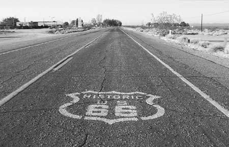
| Illustration 5 - Former U.S. Highway 66 passes through Essex, California, just south of Mojave National Preserve. (Photo by Eric Nystrom, 2001.) |
Present-day Interstate 40 roughly follows the route of U.S. Highway 66, John Steinbeck's famous "mother road." [51] The route developed initially as cross-desert motorists drove as close as possible to the Santa Fe Railway tracks, because the presence of settlements along the line made it easier to obtain supplies and help if necessary. The alignment became known as the National Old Trails Road, as it was progressively graded and developed. The Automobile Club of Southern California placed signs along its route from Los Angeles to Kansas City in 1914 and produced maps of the road to promote its use. The route was designated U.S. Highway 66 in 1926, and paving through the desert was completed by state agencies, assisted by federal funds, by 1931. The road was realigned several times; the initial route through Fenner and Goffs was bypassed in 1931 by a shorter route with a steeper grade. [52] The federal government passed legislation in 1956 that called for the construction of a system of limited access, high speed, multiple lane interstate highways. Construction of Interstate 40 came late in the history of the highway system, beginning in the late 1960s and completed through the desert in 1973. I-40 did not exactly parallel U.S. 66 for much of its length in the Mojave, and the older highway retained its designation until 1985. Since then, it has been known as the National Trails Highway, and sees moderate use as an access road. Nostalgia for Route 66 has increased as the convenience and speed of the interstates has become a fixed part of American culture, and desert towns near the Preserve like Needles, Goffs, Essex, Amboy, and Barstow count Route 66-related tourism as a significant economic strategy. [53]
Early roads from Los Angeles to Las Vegas did not follow the Union Pacific through the desert because of the hazards of heavy sand and unpredictable water levels in the Afton Canyon area. Instead, the road, graded by the state in 1922, skipped to the north, roughly following the Old Spanish Trail, a wagon road contemporary of the Mojave Road. In 1925, the county realigned the route through Baker. Paved in 1932, the name of the road was changed; originally known as the Arrowhead Trail, the highway was designated U.S. 91. Traffic to and from Las Vegas was substantial after World War II, because of the development of Las Vegas as a resort destination. Constructed very close to the alignment of U.S. 91, Interstate 15 was finished through the area by 1964. Almost all of the small service stations supported by U.S. 91 were destroyed by I-15; those that exist today were built after the freeway was completed through the area. [54]
Just as the Mojave is home to roads and railroads that transport goods and people across the desert, the Preserve also has extensive rights of way for other means of transportation - electric utility lines, pipelines for oil and gas, and communication lines. Reportedly, the first transcontinental telephone line, constructed in 1915, once crossed the area that is now the Preserve. In 1964, at the height of the Cold War, AT&T constructed a transcontinental telephone line entirely underground. This cable was designed to be immune to a nuclear attack. The cable itself was buried at least 4 feet deep, and repeating equipment, located every four miles, was housed in a deep concrete vault below a tin shack. These little sheds, located along the access road, were a readily identifiable feature in the desert for many years. The underlying cable was upgraded in the early 1980s to newer technology. [55]
|
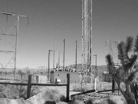
| Illustration 6 - High-tension power wires and associated infrastructure mark one of Mojave National Preserve's most important utility corridors. (Photo by Eric Nystrom, 2002.) |
Many major electric transmission lines cross the Preserve, and several more are located just outside park boundaries. The first transmission lines to Hoover Dam, designed to bring electricity to the construction site, pass along the northern boundary of the Clark Mountain area, along with several other power lines and buried fiber optic cables. Two 220 kV lines from Hoover Dam, plus a 500 kV line from the Eldorado power plant in Nevada, cross the Ivanpah Valley in the middle of the Preserve. Southern California Edison began construction on the Hoover Dam line in 1936, and helped by a construction contractor with a portable camp for workers, finished the job in 1939. A second line to the dam was completed in 1942 along the same route. The towers included anti-nesting guards to keep birds away. The line to the Eldorado plant was completed in 1971. A similar 500 kV line, originating at Southern California Edison's Mohave plant near Laughlin and known as the Mohave-Lugo line, crosses the southern portion of the Preserve. [56]
Petroleum pipelines also traverse the Preserve. Southern California Gas Company constructed a 34-inch high-pressure pipeline in 1964, to carry natural gas from its sources in Oklahoma and Texas to Los Angeles. The pipeline is four to six feet underground, and is co-located west of Essex Road with Southern California Edison's Mohave-Lugo electric line. Just inside the northern boundary of the Preserve, from the western boundary near Soda Springs to the Halloran Springs area, CALNEV Pipe Line Company maintains two high-pressure pipelines that carry ninety-nine percent of all petroleum products to Las Vegas. Use of the smaller, eight-inch line began in 1961. As its 14-inch replacement entered service in 1973, the older line was shut down, but reactivated ten years later due to high demand. Almost three million gallons of petroleum products move through the lines each day. The twin petroleum pipelines, buried three feet deep, contain electronically controlled shutoff valves every fifteen miles, which take three minutes to close. [57]
The development of nationwide transportation infrastructure since the construction of the railroads left a legacy in the eastern Mojave. Routes for automobiles and trucks, first in the guise of U.S. highways and later as high-speed interstate freeways, played an important role in the development of the desert and surrounding urban areas and provide important routes of transcontinental travel. Massive electric transmission lines from Hoover Dam and modern coal-fired power plants were built across the Mojave in the late 1930s and early 1940s and again in the early 1970s. Beginning in the early 1960s, two separate pipelines began to carry fossil fuels across the desert, to Las Vegas and to Los Angeles, and a Cold War-era underground communication cable also commenced service. All of these highlighted that the Mojave desert was a place to transport things through, not to, and reinforced the status of the desert as an unwanted place.
Modern Military Training
The Mojave Desert, a "wasteland" with easy railroad access, seemed to General George S. Patton to be an excellent place to train his troops during World War II. In early 1942, Patton established the Desert Training Center, and stationed troops throughout the Mojave. Much of the heaviest activity took place to the south of the current Mojave National Preserve boundaries, but some of these wartime camps and much of the maneuver areas were inside the present Preserve. A major division-size camp, Camp Clipper, was located north of Essex, with its northern boundary located inside the Preserve, north of I-40. A support division, including an ammunition dump, several large warehouses, and a military hospital, were located at Goffs, along with an emergency airfield a mile north of the hamlet. Later, the training grounds were expanded and renamed the California Arizona Maneuver Area, and remained in use until mid-1944. At least one million soldiers spent time in the area. Tanks and other military vehicles roamed throughout the desert, conducting exercises in the valleys of the Preserve and surrounding areas. [58]
During World War II, many places in the greater Mojave desert received permanent designation as military training areas, but lack of such a status did not preclude the military from again using the eastern Mojave for practice. In May 1964, the Army staged a training exercise in the public lands west of Needles with 89,000 troops. Soldiers practiced amphibious landings on the banks of the Colorado River, troops constructed machine-gun emplacements at major crossroads, and heavy weaponry rolled across the sweeping valleys. The operation, known as "Desert Strike," caused significant impact to desert plants and animals. At least some locals attempted to halt the operation, but were unable to get support from the BLM or conservation groups. [59] One author pointed out that the maneuver "laid environmental waste to sizable swaths of the East Mojave." [60] Fortunately for the fragile lands of the east Mojave, Operation Desert Strike was the last major military use of the area now encompassed by the Preserve.
The army's training exercises left permanent scars on the desert. Tank tracks remain visible in many places inside and outside the Preserve. Rock alignments laying out huge tent camps dot the desert, especially in the southeast corner of the Preserve, and military debris still litters the desert floor in some places. Military use compacted the soil and changed the natural ecology of the desert. [61]
Military use of the Mojave for training purposes had civilian ramifications as well. The military systematically mapped the entire Mojave desert in detail for the first time, utilizing aerial photography and traditional land-based methods to create maps for their training operations. After the war, many of the Army maps were sold to the public, and the U.S. Geological Survey utilized Army Map Service data to produce a series of 15 minute quads of the desert in the late 1940s and early 1950s. [62] The experiences of soldiers at the wartime desert camps translated to increased recreational use of the desert after the war. War surplus jeeps and camping gear enabled former soldiers and their friends to explore the desert in four-wheel drive, as they had done during their training, with new maps of the Mojave to guide their travels. [63] One U.S. Army photo, dated 1942, shows a soldier in full battle gear steering a huge military Harley-Davidson motorcycle down a Mojave sand dune - a stunning prelude of recreation to come. [64]
Recreation
Recreational use of the desert began before World War II, but accelerated tremendously after that conflict concluded. The rise of recreation by off-highway vehicles (OHV) eventually prompted increased management of the entire desert by the BLM , and will be addressed in the following chapter. In addition to OHV users, others made attempts to encourage recreation in the eastern Mojave.
|
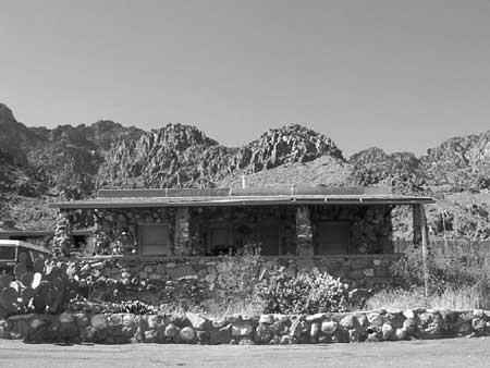
| Illustration 7 - Jack and Ida Mitchell lived near the caverns in this house which is now a visitor's center for Providence Mountains State Recreation Area. The state park is located inside Mojave National Preserve. (Photo by Eric Nystrom, 2001.) |
Jack Mitchell, a Los Angeles businessman who lost almost everything in the 1929 stock market crash, initiated an early attempt at recreational tourism in the present-day Preserve. Mitchell became interested in three magnificent limestone caverns after a local rancher, Mark Pettit, showed him the caves. By 1932, Mitchell had explored the caves, offered tours, and set up signs along Route 66 to direct visitors to the site. He continued to guide visitors for the next two decades. As Mitchell grew closer to retirement age in the early 1950s, he began deliberations with California's state park system to take over operation of the caves as a state park. Mitchell was killed in an accident before negotiations could be finalized, and the California state park system added Mitchell's Caverns to its holdings in 1956. The state promoted the tourism and development of the caverns and the surrounding Providence Mountains State Recreation Area, and dug a connection between the two main caves in Mitchell's Caverns to produce a single-loop tour experience. The caves and the state park continue to draw thousands of visitors every year to the area, and are the oldest formal tourism-related activity in the Mojave National Preserve. Originally, two more state parks were planned for Cima Dome and the Cinder Cones, but these were never built. [65]
|
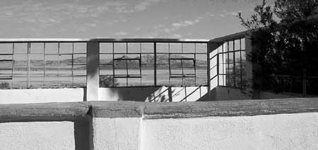
| Illustration 8 - Springer's pool enclosure at Zzyzx overlooks Soda Lake. (Photo by Eric Nystrom, 2001.) |
The California Department of Fish and Game (CDF&G) long encouraged recreational hunting in the eastern Mojave desert, as in the rest of the state. During the 1940s, CDF&G stocked non-native mule deer in what later became the Preserve. Deer are native to some parts of the desert, but the eastern Mojave, by 1940, was a landscape constructed by ranchers for production of beef. Hunting was seen by the ranchers as an undesirable intrusion of animals that would compete with their cattle and people who might damage their property. One local angrily categorized the action as "dumping them on land where ranchers were paying for the forage rights and where, with hunting, they have been a source of trouble ever since." Winnie Southcott, wife of the owner of the Gold Valley Ranch, died after she was attacked in her front yard by a large buck who apparently had no fear of humans. [66] By the mid-1980s, hunters harvested an average of 25 deer each year from the area of the Preserve, about a quarter of the total for San Bernardino County. California Department of Fish and Game also introduced chukar, an upland game bird popular with hunters, in the mid-twentieth century. Hunting of bighorn sheep had long been prohibited in the desert, but beginning in the fall of 1987, limited hunting was allowed to resume by CDF&G. [67] From the 1940s to the beginning of the twenty-first century, the state of California actively attempted to increase recreation opportunities in the eastern Mojave by locally implementing statewide programs designed to promote and sustain hunting.
While CDF&G attempted to make the desert amenable to hunters and Jack Mitchell tried to profit by showcasing its wondrous caves, a controversial preacher promoted an alternative vision of recreation in the Mojave. In September 1944, "Dr." Curtis Howe Springer, a radio evangelist and alternative-medicine salesman, staked mining claims at the site of Soda Springs, which he gradually developed into his famous Zzyzx Mineral Springs and Health Resort. Springer was a curious historical character who can be painted as a swindling quack or a misunderstood visionary. Springer constructed most of the buildings at Zzyzx today before 1955, utilizing men from the slums of Los Angeles for labor. Treatment at Zzyzx included good food and plenty of rest, along with an alcohol-free environment, which certainly helped some visitors. Lodging and meals were provided free of charge, though donations were encouraged.
Over time, Zzyzx proved very popular. The post office in Baker was upgraded to first-class status, largely because of Springer's mail volume, and motels there often lodged prospective visitors waiting for their turn at Zzyzx. In the late 1960s and early 1970s, after a series of articles in the Los Angeles Times raised the public's awareness of the seemingly illegitimate side of the Zzyzx business, several agencies, including the BLM and the Food and Drug Administration, pursued charges against Springer for allegedly false advertising, misleading labels, and misusing mining claims. BLM rangers bodily evicted Springer and his wife in April 1974 on the grounds that Springer was trespassing on public lands because he was living on his mining claims rather than extracting minerals from them. The BLM showed the Springers little sympathy, threatening them with handcuffs and giving them thirty-six hours to gather their possessions and vacate the property. Two years later, after some BLM consternation about what to do with Zzyzx, the California State University Desert Studies Consortium was granted a renewable lease to run the property as a research and education facility. [68]
After World War II, recreational use of the desert grew to substantial importance. From Jack Mitchell's attempts to make a living by giving tours of limestone caves to Curtis Springer's decades-long development and promotion of Zzyzx Mineral Springs, private interests used the eastern Mojave for economic gain through recreation and tourism. The State of California also sought to increase recreational opportunities by introducing non-native animals to the area as a means of increasing hunting. Recreation by off-highway vehicle users became so substantial that it prompted the first major systematic federal management of the desert. Beginning recently and growing rapidly, few could have predicted the speed with which recreation became a major activity on the lands of the east Mojave.
One of the least populated areas in the United States, the eastern Mojave saw relatively little management of any sort for much of its recent history. Euro-American traders chose to avoid the Mohaves when possible, but even after the establishment of a wagon road, military presence was limited to a thin corridor. Miners extracted wealth from the land, subject to only the permissive provisions of the General Mining Law of 1872. Ranchers used federal land as their own, possessing genuine title only to land around water sources. Homesteaders futilely plowed their personal portion of the public domain, but few were able to patent their holdings and none were subject to more oversight than that provided by hostile local ranchers. Military exercises used the eastern Mojave as a playground, and railroads, interstate freeways, electrical transmission lines, and petroleum pipelines were all constructed across the land. Increased management appeared on the distant horizon with the passage of the Taylor Grazing Act of 1934, which required Mojave ranchers to change their practices and their landscapes to fit the new regulations. Only in the 1960s did the desert face an issue large enough to demand major attention. Recreation in the desert surged in popularity, and forced the federal government to move toward systematic management of the desert for the first time.
| <<< Previous | <<< Contents >>> | Next >>> |
moja/adhi/chap2.htm
Last Updated: 05-Apr-2004