|
Mormon Pioneer National Historic Trail Illinois-Iowa-Nebraska-Utah-Wyoming |
|
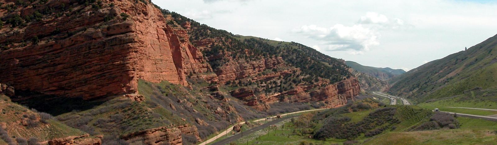 NPS photo | |
The Route West
To the sounds of snapping harness and creaking wagon wheels the pioneers in the vanguard of westward expansion moved out across the North American continent. Between 1840 and 1870, more than 500,000 emigrants went west along the Great Platte River Road from departure points along the Missouri River. This corridor had been used for thousands of years by American Indians and in the mid-1800s became the transportation route for successive waves of European trappers, missionaries, soldiers, teamsters, stage coach drivers, Pony Express riders, and overland emigrants bound for opportunity in the Oregon Territory, Great Basin, and California gold fields.
The trunk of the corridor generally followed the Platte and North Platte rivers for more than 600 miles, then paralleled the Sweetwater River before crossing the Continental Divide at South Pass, Wyo. Beyond South Pass the route divided several times, each branch pioneered by emigrants seeking a better way to various destinations. The route's importance declined with the completion of the transcontinental railroad in 1869 but continued to receive limited use into the early 1900s.
An Exodus
The Mormon Pioneer Trail
Few years in the Far West were more notable than 1846. That year saw a war start with Mexico, the Donner-Reed party embark on their infamous journey into a frozen world of indescribable horror, and the beginning of the best organized mass migration in American history. The participants of this migration, the Mormons, would establish thriving communities in what was considered by many to be a worthless desert.
From 1846 to 1869 more than 70,000 Mormons traveled along an integral part of the road west, the Mormon Pioneer Trail. The trail started in Nauvoo, Ill., traveled across Iowa, connected with the Great Platte River Road at the Missouri River, and ended near the Great Salt Lake in Utah. Generally following pre-existing routes, the trail carried tens of thousands of Mormon emigrants to a new home and refuge in the Great Basin. From their labors arose the State of Deseret, later to become Utah Territory, and finally the State of Utah.
The Trail Experience
The Mormon pioneers shared similar experiences with others traveling west: the drudgery of walking hundreds of miles, suffocating dust, violent thunderstorms, mud, temperature extremes, bad water, poor forage, sickness, and death. They recorded their experiences in journals, diaries, and letters that have become a part of our national heritage.
The Mormons were a unique part of this migration. Their move to the Valley of the Great Salt Lake was not entirely voluntary; but to maintain a religious and cultural identity it was necessary to find an isolated area where they could permanently settle and practice their religion in peace. This was a movement of an entire people, an entire religion, and an entire culture driven by religious fervor and determination.
The Mormon pioneers learned quickly to be well-organized. They traveled in semi-military fashion, grouped into companies of 100s, 50s, and 10s. Discipline, hard work, mutual assistance, and devotional practices were part of their daily routine on the trail. Knowing others would follow, they improved the trail and built support facilities. Businesses, such as ferries, were established to help finance the movement. They did not hire professional guides. Instead, they followed existing trails, used maps and accounts of early explorers, and gathered information from travelers and frontiersmen they met along the way. An early odometer was designed and built to record their mileage while traveling on the trail. In the end, strong group unity and organization made the Mormon movement more orderly and efficient than other emigrants traveling to Oregon and California.
The Search for a Home
The Mormon Church
The Mormon pioneer experience is closely tied to the formation, growth, and development of their church, which was founded by Joseph Smith, April 6, 1830, in Fayette, N.Y. Within a few years it was known as the Church of Jesus Christ of Latter-day Saints. According to the accounts of Mormon history, Joseph Smith translated a document from golden plates given to him by an angel. This document, The Book of Mormon, became the cornerstone of the new religion, and the name Mormon was applied to those who subscribed to these beliefs.
The church headquarters subsequently moved to Ohio, Missouri, and, in the spring of 1839, Nauvoo, Ill. It remained there until 1846, when the church moved beyond the Rocky Mountains into then unsettled Mexican territory in the Great Basin. There, Mormon leaders hoped to be insulated from further harassment, antagonism, and persecution. Membership grew rapidly from 1830 to 1845, and the church prospered. Hostility, fear, and controversy, however, surrounded the church. The rapid growth of church membership, the financial success of the members and their church, religious beliefs that were outside mainstream Christian tradition, the practice of plural marriage (polygamy), a large well-armed militia, the blurring of lines between church and state, and the perception by some non-Mormons that the church was a threat all fueled intolerance. Hostilities escalated, and on June 27, 1844, Joseph Smith and his brother Hyrum were killed by an angry mob while jailed in Carthage, Ill.
By 1845 the Mormon population in and around Nauvoo had grown to more than 11,000, making it one of the largest cities in the state. In September 1845 foes burned more than 200 Mormon homes and farm buildings outside Nauvoo in an attempt to force the Mormons to leave.
A move to the Far West had been discussed by church leaders as early as 1842, with Oregon, California, and Texas considered as potential destinations. In 1844 Joseph Smith obtained John C Fremont's map and report, which described the Great Salt Lake and its surrounding fertile valleys. Subsequently, the Rocky Mountains and the Great Basin became the prime candidates for settlement.
Heading West
Establishing the Trail: The Treks of 1846 and 1847
The first movement of the Mormons from Nauvoo to the Valley of the Great Salt Lake occurred in two segments: one in 1846, the other in 1847. The first segment, across Iowa to the Missouri River, covered around 265 miles. The second segment, from the Missouri River to the Valley of the Great Salt Lake, covered more than 1,000 miles.
The Trek of 1846
The departure from Nauvoo began on February 4, 1846, under the leadership of Brigham Young, who succeeded Joseph Smith as leader of the Mormon Church. After crossing the Mississippi River, the journey across Iowa followed primitive territorial roads and Indian trails. The initial party reached the Missouri River on June 14 of that year, having taken more than four months to complete the trip. Some of the emigrants established a settlement called Kanesville on the Iowa side of the river. Others moved across the river into the area of present-day (north) Omaha, Nebr., building a camp called Winter Quarters.
The Mormons left Nauvoo earlier than planned because of the revocation of their city charter, growing rumors of U.S. government intervention, and fears that Federal troops would march on the city. This early departure exposed them to the elements in the worst of winter. Heavy rains later turned the rolling plains of southern Iowa into a quagmire of axle-deep mud. Furthermore, few people carried adequate provisions for the trip. The weather, general unpreparedness, and lack of experience in moving such a large group of people, all contributed to the difficulties they endured.
Crossing the Plains
Along this first part of the trail, the Mormons developed skills for moving en masse. They established several semi-permanent camps, including Garden Grove and Mount Pisgah, where they planted crops and built facilities to assist those who followed. It was during this leg of the journey that Brigham Young first organized them into companies of 100s, 50s, and 10s. The lessons learned crossing Iowa were used by future companies of Mormons.
The Trek of 1847
The longest leg of the journey began at Winter Quarters on April 5, 1847, and ended on July 24, 1847, when Brigham Young entered the Valley of the Great Salt Lake. The trip went smoother than the previous year's journey because the Mormons were better organized, had better provisions, and began the trek when trail conditions were optimal.
The lead pioneer party left with 148 people (143 men, three women, and two young boys), 72 wagons, 93 horses, 66 oxen, 52 mules, 19 cows, 17 dogs, and some chickens. This hand-picked group was organized into two large divisions and further split into companies of 50 and 10. This organizational structure was based on Brigham Young's plan for migrating west. The plan also included details on camp behavior and devotional practices to be followed during the journey. The trail across the Great Plains traversed hundreds of miles along the north side of the Platte and North Platte rivers. At Fort Laramie the Mormons crossed to the south side of the river, where they joined the Oregon Trail. About 100 miles later, they left the North Platte River at present day Casper, Wyo. They then followed the Sweetwater River for almost 100 miles and crossed the Continental Divide at South Pass. At Fort Bridger they left the Oregon Trail and struck out on their own following a route first recommended by California promoter Lansford Hastings and pioneered in 1846 by four companies of emigrants bound for California. These four companies blazed two different routes into the Salt Lake Valley. The Mormons followed the faint, year-old track of the ill-fated Donner-Reed party through the Wasatch Mountains.
The final 116 miles, from Fort Bridger to the Valley of the Great Salt Lake, were the most difficult. The people were weary, their wagons worn, and livestock weakened by almost 1,000 miles of walking. Travel through the narrow, willow-choked canyons and over tree-covered slopes and rocky ridges of the Wasatch Range was so slow that it took the pioneer party 14 days to complete this part of their journey. On July 22, 1847, when Thomas Bullock caught his first full view of the valley he shouted "hurra, hurra, hurra, there's my home at last."
The pioneer party began planting late crops as soon as they reached the valley. During the next few weeks, they laid out streets, built temporary shelters, and prepared for winter. Mormon emigrants continued to arrive during the remaining weeks of summer and fall, and approximately 1,650 people spent their first winter in the valley. Shortly after their arrival, Brigham Young and many members of the pioneer party made the return trip to Winter Quarters to be with their families and to organize the next spring's migration to the valley.
The next 20 years would see about 70,000 Mormons traveling by wagons and handcarts to the Valley of the Great Salt Lake. Overland wagon travel declined after the completion of the transcontinental railroad in 1869, when emigrants could travel across the plains by rail.
The Ones Who Walked
The Handcarts: 1856 to 1860
A unique feature of the Mormon migration was their use of handcarts. Handcarts, two-wheeled carts that were pulled by emigrants, instead of draft animals, were sometimes used as an alternate means of transportation from 1856 to 1860. They were seen as a faster, easier, and cheaper way to bring European converts to Salt Lake City. Almost 3,000 Mormons, with 653 carts and 50 supply wagons, traveling in 10 different companies, made the trip over the trail to Salt Lake City. While not the first to use handcarts, they were the only group to use them extensively.
The handcarts were modeled after carts used by street sweepers and were made almost entirely of wood. They were generally six to seven feet long, wide enough to span a narrow wagon track, and could be alternately pushed or pulled. The small boxes affixed to the carts were three to four feet long and eight inches high. They could carry about 500 pounds, most of this weight consisting of trail provisions and a few personal possessions.
All but two of the handcart companies completed the journey with few problems. The fourth and fifth companies, known as the Martin and Willie companies, left Winter Quarters in August 1856. This was very late to begin the trip across the plains. They encountered severe winter weather west of present-day Casper, Wyo., and hundreds died from exposure and famine before rescue parties could reach them. While these incidents were a rarity, they illustrate that the departure date from the trailhead was crucial to a successful journey.
The Mormon Pioneer Trail
The Trail Today
Congress established the Mormon Pioneer National Historic Trail as part of the National Trails System on November 10, 1978. This historic trail commemorates the 1846-47 journey of the Mormon people from Nauvoo, Ill., to the Valley of the Great Salt Lake. The designated corridor is almost 1,300 miles long and is managed as a cooperative effort among private landowners, trail associations, state and local agencies, the National Park Service, the Bureau of Land Management, and the USDA Forest Service. Land ownership along the trail is comprised of 822 miles (64 percent) on private land, 264 miles (20 percent) under federal management, and 214 miles (16 percent) in state and local ownership. Much of the trail is no longer visible, though some trail segments and sites can be visited. Long stretches of the trail can still be seen in Wyoming. If you want to visit sites on private land you must obtain the landowner's permission.
Important dates in the 1846 and 1847 treks from Nauvoo, Illinois to Utah are noted. Quotations from contemporary diaries and letters describe those years.
February 4, 1846
First wagons leave Nauvoo and cross the Mississippi River.
The great severity of the weather, and ... the difficulty of crossing the river during many days of running ice, all combined to delay our departure, though for several days the bridge of ice across the Mississippi greatly facilitated the crossing....
—Brigham Young, February 28, 1846
April 24, 1846
Garden Grove, the halfway point across Iowa, is reached. This was one of
several semi-permanent camps set up for the use of later emigrants.
June 14, 1846
Brigham Young arrives at the banks of the Missouri River.
September 1846
Winter Quarter: is set up on the Nebraska shore of the Missouri River.
Approximately 4,000 people spent the winter here.
November 1846
Father Pierre de Smet, a Jesuit missionary, visits with the Mormons in
Winter Quarters and provides information about the Great Basin area.
April 5, 1847
The first group, led by Brigham Young, leaves Winter Quarters.
I walked some this afternoon in company with Orson Pratt and suggested to him the idea affixing a set of wooden cog wheels to the hub of a wagon wheel, in such order as to tell the exact number of miles we travel each day.
—William Clayton, April 19, 1847
May 26, 1847
Emigrants pass Chimney Rock.
In advance of us, at a great distance can be seen the outlines of mountains, loftier than any we have yet seen ... their summits... covered with snow.
—Horace Whitney, June 23, 1847
June 27, 1847
Mormons cross South Pass, the Continental Divide.
. . . and beholding in a moment such an extensive scenery open before us, we could not refrain from a shout of joy which almost involuntarily escaped from our lips the moment this grand and lovely scenery was within our view.
—Orson Pratt, July 21, 1847
July 24, 1847
Brigham Young arrives in the Valley of the Great Salt Lake.
Exploring the Trail
The restored city of NAUVOO contains open space, homes, shops, and the Joseph Smith and Brigham Young houses. After leaving Nauvoo in 1846, the first Mormons crossed the Mississippi to MONTROSE. They organized themselves for the trek across Iowa at SUGAR CREEK CAMP.
An advance party made camp at GARDEN GROVE on April 25, 1846. Within two weeks they cleared 300 acres, planted crops, built log houses, and cut 10,000 rails for fencing and enough logs for 40 more houses. The site continued as a way station until 1852.
Named for its Biblical counterpart, MOUNT PISGAH served as a way station until 1852.
The Mormons called this area KANESVILLE. Later known as COUNCIL BLUFFS, its importance to western expansion dates back to 1804, when Lewis and Clark met with Indians near here. Kanesville was a major staging area for pioneers heading west.
WINTER QUARTERS (North Omaha) was the major camp of the Mormons during the winter of 1846-47 while they prepared to move west.
The ELKHORN RIVER ferry was the first major crossing west of the Missouri. At a site later known as LIBERTY POLE CAMP, the 1847 Mormon emigrants organized themselves in a military manner to provide traveling effectiveness and safety.
Mormon pioneers devised a "roadometer" at the suggestion of William Clayton. Where it was first used is now known as the ODOMETER START. Previously Clayton had kept track of distance by tying a red cloth to a wheel and counting the revolutions.
SCOTTS BLUFF was one of the major landmarks on the trail, along with CHIMNEY ROCK to the east. The grave of REBECCA WINTERS, one of the few identified graves of the 6,000 or so Mormons who died crossing the plains, is nearby.
The early trading post of FORT LARAMIE quickly developed into a key resupply point for emigrants and a major military fort. Here the Mormon and Oregon-California trails merge.
Of the thousands of names carved into the soft sandstone of REGISTER CLIFF, several hundred are still legible. The GUERNSEY RUTS, as deep as five feet, are three miles west.
MORMON FERRY was the first Commercial ferry on the Platte River, established in June 1847. The FORT CASPAR museum has a full-sized replica of the original ferry.
Near INDEPENDENCE ROCK—named by fur trappers who first stopped here July 4, 1830—emigrants reached the refreshing waters of the Sweetwater River. Many names and dates can still be seen on the rock face.
The MARTIN HANDCART COMPANY of 1856 was caught in the October blizzard. Rescue wagons from Salt Lake City brought food and clothing. The company continued its trek to a temporary refuge at MARTIN'S COVE. Although some 150 died, more than 425 handcart pioneers were saved.
The 1856 WILLIE HANDCART COMPANY wad caught along the Sweetwater River in the October 1856 blizzard. Rescue wagons at the Sweetwater and ROCK CREEK helped save some 430 of the 500 emigrants who crossed over ROCKY RIDGE to camp at Rock Creek.
SOUTH PASS was called the "Cumberland Gap of the Far West." Here pioneers crossed the Continental Divide on a gentle grade that was easy on the wagons.
Mormon pioneers built rafts and floated wagons across the Green River here. In 1847 they built a ferry (later known as LOMBARD FERRY) and provided a commercial service for travelers.
One of two "stations" on the trail at the onset of the 1847 pioneer journey FORT BRIDGER became a military post. The Mormons bought the fort in 1855 to supply emigrant parties.
The narrow, 16-mile gorge of ECHO CANYON impressed pioneers with its particular echo. The canyon also includes stone breastworks built in 1857 to guard against an invasion by Federal troops to suppress a rumored Mormon rebellion.
LITTLE EMIGRATION CANYON was one of the last climbs before reaching Salt Lake Valley and is now marked by a 4-mile hiking trail from MORMON FLAT to BIG MOUNTAIN PASS where the emigrants caught the first view of their new home. An additional hiking trail extends another 5 miles from the top of the pass, down Dell Canyon to Little Dell Reservoir.
The Donner-Reed party's final obstacle into the Salt Lake Valley in 1846 was the difficult climb over DONNER HILL. This climb and other delays significantly contributed to the disaster in the Sierra Nevada later that year.
In THIS IS THE PLACE HERITAGE PARK. A 60-foot-high monument honors the Mormon pioneers and others who explored the Great Basin.
Upon entering Salt Lake Valley and coming to TRAIL'S END, Mormon pioneers immediately began a permanent settlement by farming, building shelters, and establishing local trades.
Exploring the Mormon Pioneer Trail
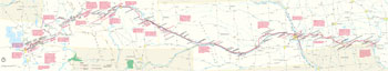 (click for larger map) |
For more information on the history of the trail, locating sites, or traveling segments of the trail, you may contact:
National Historic Trails Interpretive Center
1501 N. Poplar Street
Casper, WY 82601
www.blm.gov
Historical Department
Church of Jesus Christ of Latter-day Saints
50 E. North Temple
Salt Lake City, UT 84150
National Park Service
National Trails System-Salt Lake City
324 South State Street
Suite 200
P.O. Box 45155
Salt Lake City, UT 84145
Internet Information
www.nps.gov/mopi
http://history.utah.gov/partners/mta
www.liscoplus.com/~iowamormontr
Auto Tour Route Guides
These interpretive guides provide descriptions and driving directions to
trail sites. Download them from the Mormon Pioneer National Historic
Trail website: www.nps.gov/mopi
Source: NPS Brochure (2004)
|
Establishment Mormon Pioneer National Historic Trail — November 10, 1978 |
For More Information Please Visit The  OFFICIAL NPS WEBSITE |
Documents
Auto Tour Route Interpretive Guides (National Historic Trails):
The Mormon Pioneer Trail Across Iowa in 1846 (Map) (April 2007)
Nebraska and Northeastern Colorado (Map) (August 2006)
Across Wyoming (Map) (July 2007)
Utah — Crossroads of the West (Map) (September 2010)
Comprehensive Plan and Finding of No Significant Impact: Mormon Pioneer National Historic Trail (September 1981)
Historic Resource Study: Mormon Pioneer National Historic Trail (HTML edition) (Stanely B. Kimball, May 1991)
Interpretive Plan, Mormon Pioneer National Historic Trail (April 27, 1992)
Long-Range Interpretive Plan, Oregon, California, Mormon Pioneer, and Pony Express National Historic Trails (August 2010)
Management Plan, Oregon/Mormon Pioneer National Historic Trails (BLM, 1986)
Narrative of the March of Company A, Engineers from Fort Leavenworth, Kansas, to Fort Bridger, Utah, and Return, May 6 to October 3, 1858 (William P. Seville and John W.N. Schulz, 1912)
The 1854 Mormon Emigration at the Missouri-Kansas Border (Fred E. Woods, extract from Kansas History: The Journal of the Central Plains, Vol. 32 No. 4, Winter 2009-2010)
The Mormon Trail: A Study Report (June 1978)
mopi/index.htm
Last Updated: 01-Jan-2025