|
Muir Woods National Monument California |
|
 NPS photo | |
William Kent's Legacy Until the 1800s many northern California coastal valleys were covered with coast redwood trees like those found in Muir Woods National Monument. The forest along Redwood Creek in today's Muir Woods was spared from logging because it was hard to get to. Because this area contained one of the Bay Area's last uncut stands of old-growth redwood, Congressman William Kent and his wife Elizabeth Thacher Kent bought 295 acres here for $45,000 in 1905. To protect the redwoods the Kents donated the land to the Federal Government. President Theodore Roosevelt proclaimed it a national monument in 1908. He suggested naming the area after Kent, but Kent wanted it named for conservationist John Muir.
John Muir: Philosopher, Scientist, Author Young John Muir's family emigrated from Scotland to Wisconsin in 1848. Muir showed a lively interest in nature, and, after brief studies at the University of Wisconsin, he left school for what he would call "the University of the Wilderness." During his lengthy wanderings Muir contemplated the relationship between humans and the rest of nature, concluding that all life forms have inherent value and a right to exist. He believed humans are no greater or lesser than other forms of life. His writings brought broad public acceptance of conservation as an environmental ethic. Muir has inspired generations of advocates to work to protect wilderness, wildness, and natural areas.
"This is the best tree-lover's monument that could possibly be found in all the forests of the world. You have done me great honor, and I am proud of it."
—Muir to William Kent
Life of the Redwood Forest
Each season at Muir Woods has its own character. Fall is the warmest: ladybugs swarm, and water striders are active in Redwood Creek, and the leaves of bigleaf maple turn yellow and drop. In winter, steelhead (migratory rainbow trout) and silver salmon migrate up Redwood Creek to spawn, and toyon berries turn vibrant red. In spring, birds nest, wildflowers dot Redwood Canyon, and black-tailed deer birth spotted fawns. Summer is the season of fog, azaleas, aralias, buckeyes, Steller's jays, and chipmunks.
Animals Notice the relative silence in these woods. Animal life in a redwood forest is limited because the shaded conditions provide scarce food. Many animals feed at night, as owls and bats do, or in early morning and around dusk, as deer do. Mammals most often seen are Sonoma chipmunks and black-tailed deer. You may hear Steller's jays scolding or ravens cawing. Migrating warblers, kinglets, and thrushes live here part of the year. Winter wrens live here year-round. Reptiles and amphibians include western garter snakes, rubber boas, and Pacific giant salamanders. Also look for bright banana slugs.
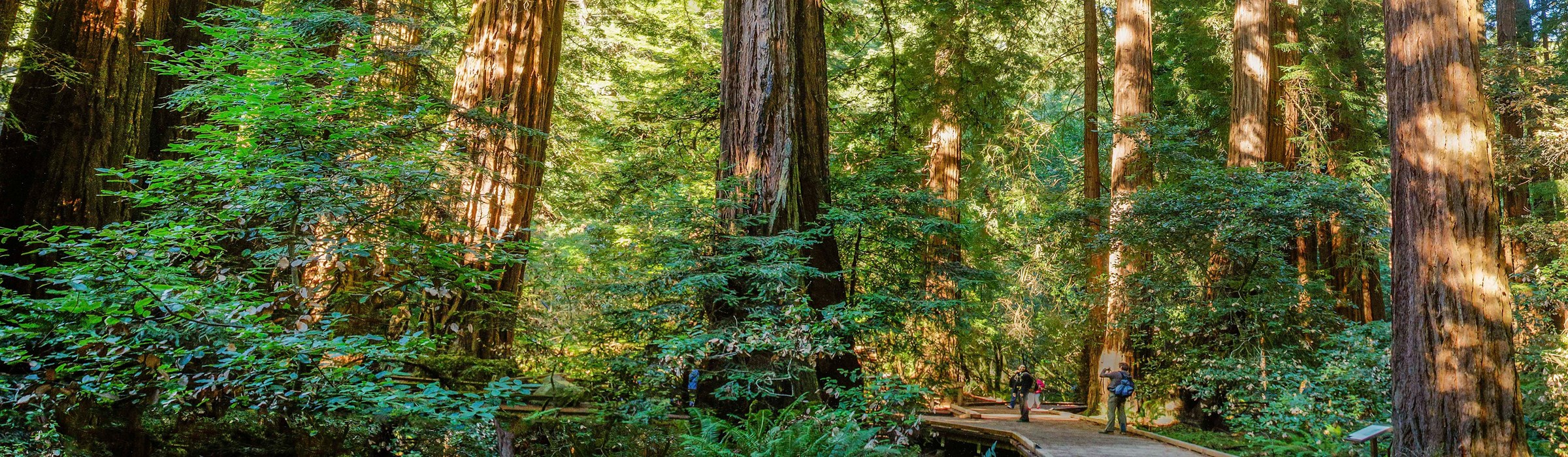
Trees Coast redwood trees dominate this forest. With them grow Douglas fir, big-leaf maple, tanbark oak, and bay laurel. At the canyon's lower end red alders line the stream, and buckeyes cluster nearby. Shaded bays growing toward the light may assume contorted shapes or even topple over.
Plants of the Forest Floor Ferns are common forest associates of redwoods. Most common here are sword fern, ladyfern, California polypody, and bracken fern. Moss and lichen grow on rocks and trees but are not parasitic. Redwood sorrel carpets much canyon floor. Abundant mushrooms and fungi appear after rains. Magnificent shelf fungi are seen year-round on both live and dead trees. Vermilion hygrophorous and oyster mushrooms appear only seasonally. Fields of primitive horsetail plants grow near the creek's banks.
Redwood Creek Redwood Creek originates high on the slopes of Mt. Tamalpais and nearly bisects the park. It runs year-round, providing nearby trees and animals with water, and is host to diverse aquatic creatures, including fish, insects, and salamanders. In summer the creek slows to a trickle connecting quiet pools, but winter rainstorms turn it into a raging torrent. Rain-swollen, Redwood Creek breaks through the sand barrier at Muir Beach, and adult steelhead and silver salmon move up the creek to spawn.
California Redwoods
Redwood-like trees covered much of the Northern Hemisphere 140 million years ago. As the climate changed, the range of the redwood retreated. Now there are two species of redwood in California, with very limited ranges. The coast redwood (Sequoia sempervirens) grows on a thin and discontinuous 500-mile strip of Pacific coast from southern Oregon to Monterey. Most old-growth coast redwoods have been cut, but some are protected in Redwood National and State Parks, many California and Oregon state parks, and here in Muir Woods. This canyon of redwoods was never logged. Its forest of mixed-age and dead trees supports a biologically rich community of plants and animals.
Closely related, the giant sequoia (Sequoiadendron giganteum) grows larger in bulk but is less tall than the coast redwood. Giant sequoias can be seen in Yosemite and Sequoia and Kings Canyon national parks. Their range is restricted to small groves on the Sierra Nevada's west slope.
Redwood
Height to 370 ft.
Age to 2,000 yrs.
Diameter to 22 ft at breast height
Bark to 12 in. thickGiant Sequoia
Height to 311 ft.
Age to 3,200 yrs.
Diameter to 40 ft. at breast height
Bark to 31 in. thick
Coast Redwoods: Tallest Living Things
Bohemian and Cathedral groves have the biggest trees in Muir Woods—one 252 feet tall and one 14 feet wide. Some are at least 1,000 years old. Most mature trees are 500 to 800 years old. Coast redwoods grow best in moderate temperatures and protected from the wind and salt spray. They need substantial soil moisture from rainfall and summer fog and grow tallest on floodplains of streams that flood periodically. The world's tallest living thing is a coast redwood in northern California. One identified by the National Geographic Society in 1963 measured 367.8 feet tall.
Roles of Fog and Fire
Fog Redwoods flourish only in coastal California's fog belt, where frequent summer fog supplies critical moisture in the dry season. Condensing on leaves and needles, fog drips to the forest floor, replenishing water that trees lose to evaporation and transpiration. Winter is the wet season; rainfall averages 40 inches per year.
Fire Fire benefits long-term forest health. Fire clears the floor of duff so redwood seeds can reach mineral soil. It destroys bacteria and fungi in the duff layer that can kill seeds before they germinate. It recycles nutrients, turns debris into ash, and can enhance wildlife forage. Until fire suppression, begun in the 19th century, upset the natural cycle, wildfire occurred every 20 to 50 years here. To restore the ecosystem's integrity the National Park Service conducts prescribed burning to re-establish fire's natural role in the forest.
Thick Bark
Its spongy and fibrous bark—from six to 12 inches thick—insulates the mature redwood against fire damage. Repeated hot fires can burn through the bark and expose heartwood to dry rot. Later fires may hollow out rotted portions—the blackened cavities you may see along the trail. A reddish-brown, bitter chemical, tannin, gives the tree its name. Tannin also makes both bark and wood resistant to fire and attack by insects and fungi.
Cones and Seeds
Redwoods are conifers and evergreen. Mature cones are woody, reddish brown, and small, olive-sized. Cones mature in a year and drop seeds, 50 to 60 tiny flakes per cone, in late fall. Within one month, warm, moist soil may stimulate a seed to germinate. If it is on suitable, fresh mineral soil it will root. After the first leaves appear, a seedling begins making its own food and may grow two or three inches tall in its first year of life.
Burls and Sprouting
In established forests like Muir Woods, burl sprouting accounts for most reproduction of redwoods. A burl is a mass of dormant buds that grows at the base or on the roots or side of redwoods. When a tree is injured or tissue near a burl is affected, the burl may sprout. Sprouting gives redwoods great competitive advantage over other trees that reproduce by seed only. Tightly grouped redwoods, or those fused at their bases, probably began life as burl sprouts.
Visiting Muir Woods
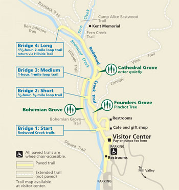 (click for larger map) |
Muir Woods National Monument, 12 miles north of Golden Gate Bridge, is reached by U.S. 101 and Calif. 1. Parking is limited: try visiting on weekdays, mornings, or late afternoons. Approach roads are steep and winding; vehicles over 35 feet long are prohibited. No public transportation serves the park. Jackets are advised: daytime temperatures average 40° to 70°F. A visitor center and self-guiding nature trail are provided. A gift shop offers snacks and souvenirs. Find gasoline and services in Mill Valley five miles away. The park is open 8 a.m. to sunset year-round. Ages 17 and up pay an entrance fee.
Muir Woods is part of Golden Gate National Recreation Area. Visit the National Park Service at our website: www.nps.gov
Protect Your Park
Muir Woods National Monument is a natural area. Please help us preserve and
protect it. • Don't mar or remove flowers, trees, or other natural
features. • Help keep wildlife healthy: don't feed or disturb animals.
Fishing is prohibited in Redwood Creek. • Pets are not permitted, except
service dogs. • No smoking on trails. • Picnicking and camping are not
allowed here, but facilities are provided nearby. • No horses or bicycles,
except on fire roads. • Portable radios are prohibited.
Danger: Poison oak and stinging nettles are common. • During high winds branches or trees may fall.
Loop Walks
Walk in Redwood Canyon to enjoy the forest. The 560-acre park includes six miles
of trails. The main, canyon floor trails are paved and mostly level. Bridges 1
to 4 make short loop walks possible. Unpaved trails out of the canyon connect
with trails in Mt. Tamalpais State Park.
Source: NPS Brochure (2001)
|
Establishment Muir Woods National Monument — January 9, 1908 |
For More Information Please Visit The  OFFICIAL NPS WEBSITE |
Documents
A Biological Survey of Redwood Creek, Muir Woods National Monument, Mill Valley, California (Kenneth W. May, September 30, 1954)
Bat Inventory of Muir Woods National Monument Final Report (Paul A. Heady and Winifred F. Frick, 2004)
California's National Parks in Peril: The Threats of Climate Disruption (Stephen Saunders and Tom Easley, ©The Rocky Mountain Climate Organization and Natural Resources Defense Council, October 2010, all rights reserved)
Cultural Landscape Report for Muir Woods National Monument (John Auwaerter, Haichaeo Wang and George W. Curry, 2021)
Cultural Landscapes Inventory: Muir Woods National Monument Historic District (2007)
Forest Structure in Muir Woods National Monument: Survey of the Redwood Canyon Old-Growth Forest NPS Natural Resource Technical Report NPS/SFAN/NRTR-2014/878 (Robert Steers, Heather Spaulding and Eric Wrubel, May 2014)
Foundation Document Overview, Muir Woods National Monument, California (January 2017)
Geologic Resources Inventory Report, Golden Gate National Recreation Area, including Fort Point National Historic Site and Muir Woods National Monument NPS Natural Resource Report NPS/NRSS/GRD/NRR-2016/1266 (Rebecca Port, August 2016)
Historic Resource Study for Muir Woods National Monument, Golden Gate National Recreation Area, Land-Use History of Muir Woods; Muir Woods, William Kent, and the American Conservation Movement; Recommendations Olmsted Center for Landscape Preservation (John Auwaerter and John F. Sears, 2006)
Junior Ranger Activity Book, Muir Woods National Monument (Date Unknown; for reference purposes only)
Long-term Monitoring of Coho Salmon and Steelhead Trout During Freshwater Life Stages in Coastal Marin County
Long-Term Coho Salmon & Steelhead Trout Monitoring in Coastal Marin County: Summer 2004 Monitoring Progress Report PORE-NR/WR-05/04 (Brannon J. Ketcham, Kirsten M. Leising and Michael Reichmuth, August 11, 2005)
Long-term Coho Salmon and Steelhead Trout Monitoring in Coastal Marin County: 2008 Annual Monitoring Report NPS Natural Resource Technical Report NPS/SFAN/NRTR—2011/460 (Sarah Carlisle, Michael Reichmuth, Allison Dedrick, Christopher Brown and Brannon Ketcham, June 2011)
Long-term Monitoring of Coho Salmon and Steelhead Trout During Freshwater Life Stages in Coastal Marin County: 2009 Annual Report NPS Natural Resource Report NPS/SFAN/NRR—2016/1212 (Michael Reichmuth, Sarah Carlisle, Allison Dedrick and Angela Rodoni, May 2016)
Long-term Coho Salmon & Steelhead Trout Monitoring in Coastal Marin County: Smolt Trapping 2010 Progress Report NPS Natural Resource Data Series NPS/SFAN/NRDS—2010/200 (Allison Dedrick, Sarah Carlisle, Michael Reichmuth and Angela Rodoni, October 2012)
Long-term Monitoring of Coho Salmon and Steelhead Trout During Freshwater Life Stages in Coastal Marin County: 2011 Annual Report NPS Natural Resource Report NPS/SFAN/NRR—2015/969 (Sarah Carlisle and Michael Reichmuth, May 2015)
Long-term Monitoring of Coho Salmon and Steelhead Trout During Freshwater Life Stages in Coastal Marin County: 2012 Annual Report NPS Natural Resource Technical Report NPS/SFAN/NRTR—2014/887 (Sarah Carlisle, Michael Reichmuth, Katelyn Jordan and Kelly Church, July 2014)
Long-term Monitoring of Coho Salmon and Steelhead Trout During Freshwater Life Stages in Coastal Marin County: 2013 Annual Report NPS Natural Resource Report NPS/SFAN/NRR—2015/956 (Sarah Carlisle and Michael Reichmuth, April 2015)
Long-term Monitoring of Coho Salmon and Steelhead During Freshwater Life Stages in Coastal Marin County: 2014 Annual Report NPS Natural Resource Report NPS/SFAN/NRR—2016/1142 (Sarah Carlisle, Michael Reichmuth and Brentley McNeill, March 2016)
Long-term Monitoring of Coho Salmon and Steelhead During Freshwater Life Stages in Coastal Marin County: 2015 Annual Report NPS Natural Resource Report NPS/SFAN/NRR—2017/1392 (Sarah Carlisle, Michael Reichmuth and Brentley McNeill, February 2017)
Long-term Monitoring of Coho Salmon and Steelhead During Freshwater Life Stages in Coastal Marin County: 2016 Annual Report NPS Natural Resource Report NPS/SFAN/NRR—2018/1577 (Sarah Carlisle, Brentley McNeill and Michael Reichmuth, February 2018)
Long-term Monitoring of Coho Salmon and Steelhead During Freshwater Life Stages in Coastal Marin County: 2017 Annual Report (Revised with Costs) NPS Natural Resource Report NPS/SFAN/NRR—2020/2190 (Michael Reichmuth, Brentley McNeill and Sarah Carlisle, November 2020)
Long-term Monitoring of Coho Salmon and Steelhead During Freshwater Life Stages in Coastal Marin County: 2018 Annual Report (Revised with Costs) NPS Natural Resource Report NPS/SFAN/NRR—2020/2192 (Brentley McNeill, Michael Reichmuth and Alex Iwaki, November 2020)
Mapping an Epidemic: Geography of Sudden Oak Death in California (Steve Zack, 2002)
Master Plan, Muir Woods National Monument, California (1972)
Monitoring Northern Spotted Owls on Federal Lands in Marin County, California
Monitoring Northern Spotted Owls on Federal Lands in Marin County, California: 2007 Annual Report NPS Natural Resource Technical Report NPS/PWR/SFAN/NRTR—2008/089 (Heather J. Jensen, Dawn B. Adams, William W. Merkle and David T. Press, January 2008)
Monitoring Northern Spotted Owls on Federal Lands in Marin County, California: 2009 Annual Report NPS Natural Resource Technical Report NPS/SFAN/NRTR—2011/432 (David Press, William W. Merkle and Heather J. Jensen, February 2011)
Monitoring Northern Spotted Owls on Federal Lands in Marin County, California: 2010–2011 Report NPS Natural Resource Technical Report NPS/SFAN/NRTR—2012/606 (David Press, William W. Merkle, Heather Jensen, Francis Taroc and Taylor Ellis, July 2012)
Monitoring Northern Spotted Owls on Federal Lands in Marin County, California: 2012 Report NPS Natural Resource Technical Report NPS/SFAN/NRTR—2013/829 (Taylor Ellis, Emily Schultz and David Press, December 2013)
Monitoring Northern Spotted Owls on Federal Lands in Marin County, California: 2013 Report NPS Natural Resource Report NPS/SFAN/NRR—2016/1180 (Taylor Ellis and Kaitlin Harrigan, March 2016)
Monitoring Northern Spotted Owls on Federal Lands in Marin County, California: 2014-2015 Report NPS Natural Resource Report NPS/SFAN/NRR—2017/1474 (Taylor D. Ellis, July 2017)
Monitoring Northern Spotted Owls on Federal Lands in Marin County, California: 2016 Report NPS Natural Resource Report NPS/SFAN/NRR—2017/1487 (Taylor D. Ellis, July 2017)
Monitoring Northern Spotted Owls on Federal Lands in Marin County, California: 2017 Report NPS Natural Resource Report NPS/SFAN/NRR—2018/1677 (Taylor D. Ellis, July 2018)
Monitoring Northern Spotted Owls on Federal Lands in Marin County, California: 2018 Report NPS Natural Resource Report NPS/SFAN/NRR—2020/2088 (Taylor D. Ellis, March 2020)
Monitoring Visitor Reactions to the Recreational Fee Demonstration Program in Muir Woods National Monument in 1999: A Summary of Output (Jerilyn L. Thompson, David W. Lime, Joanna M. Rosendahl and Cynthia A. Warzecha, April 7, 2000)
National Register of Historic Places Nomination Form
Muir Woods National Monument (John Auwaerter, April 2007)
Redwood Creek Watershed Assessment: Final Report (Stillwater Sciences & Horizon Water Environment, LLC, August 2011)
Report on Sullys Hill Park, Casa Grande Ruin; the Muir Woods, Petrified Forest, and Other National Monuments, Including List of Bird Reserves: 1915 (HTML edition) (Secretary of the Interior, 1914)
Report on Wind Cave National Park, Sullys Hill Park, Casa Grande Ruin, Muir Woods, Petrified Forest, and Other National Monuments, Including List of Bird Reserves: 1913 (HTML edition) (Secretary of the Interior, 1914)
Redwood Discovery, Muir Woods National Monument (Date Unknown; for reference purposes only)
Sustainable Access Project Biological Assessment, Muir Woods National Monument (November 2016)
Sustainable Access Project Final Environmental Assessment, Muir Woods National Monument (May 2017)
The History of the Vegetation of Muir Woods National Monument — Final Report: Phase III, Oct. 1, 1977 - Sept. 30, 1978 (Joe McBride and Diana Jacobs, 1977)
The Road Inventory of Muir Woods National Monument (March 1999)
Visitor Services Project: Muir Woods National Monument Visitor Services Project Report 27 (Margaret Littlejohn and Gary E. Machlis, March 1990)
Visitor Services Project — Appendix : Muir Woods National Monument Visitor Services Project Report 27 (Margaret Littlejohn and Gary E. Machlis, March 1990)
Visitor Use Monitoring in Muir Woods and on Alcatraz Island (Resource Systems Group, Inc., November 30, 2011)
Visitor Use Monitoring, Muir Woods, Golden Gate National Recreation Area (Resource Systems Group, Inc. and University of Vermont, November 11, 2011)
muwo/index.htm
Last Updated: 01-Jan-2025