|
Natural Bridges National Monument Utah |
|
 NPS photo | |
Discovery of the Bridges
In 1883 prospector Cass Hite wandered up White Canyon from his base camp along the Colorado River. In search of gold, he found instead three magnificent bridges water had sculpted from stone. In 1904 National Geographic Magazine publicized the bridges; in 1908 President Theodore Roosevelt proclaimed Natural Bridges National Monument, creating Utah's first National Park System area.
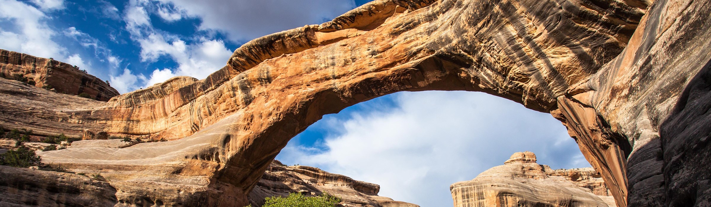
The bridges have had several names. They were first named President, Senator, and Congressman in order of height. Later explorers renamed them Augusta, Caroline, and Edwin. In 1909 the park was enlarged to protect nearby Puebloan structures, and the General Land Office affixed the Hopi names Sipapu, Kachina, and Owachomo. Sipapu means "place of emergence," the entryway by which the Hopi believe their ancestors came into this world. Kachina is named for rock art symbols that resemble symbols commonly used on kachina dolls. Owachomo means "rock mound," a feature atop the bridge's east abutment.
Early Human History People repeatedly occupied and abandoned this area from 9,000 to 700 years ago. Only rock art and tools, left by those hunting small game and gathering wild plants, show humans living here then. Ancestors of modern Puebloan people moved onto the mesa tops 1,300 years ago to dry farm—using only natural precipitation—leaving as the environment changed.
About 900 years ago new migrants from across the San Juan River lived in small, single-family dwellings near the deepest, best-watered soils throughout this area. In the 1200s, farmers from Mesa Verde migrated here, but by the 1300s the ancestral Puebloans migrated southward. Navajos and Paiutes lived here in historic time, and Navajo oral tradition holds that their ancestors lived among the early Puebloans.
The evidence these people left is fragile and irreplaceable. To help preserve it, do not enter the structures or touch or mark walls or rock art. Leave artifacts in place and stay on trails.
Natural History Millions of years ago these sandstones were deposited and then slowly uplifted as part of the Colorado Plateau. Erosion gradually formed today's canyons and landscapes. Plant communities varied over time: Pollen studies show this area was once spruce-fir forest. Changes in climate changed the dominant plants, but pockets of Douglas fir still dot cooler, moist, north-facing cliffs near Sipapu Bridge.
Infrequent and unpredictable, precipitation can be dramatic—with long droughts to periods of heavy rain and snow. Plants and animals have adapted to this environment. Cryptobiotic soil, the black and lumpy crust here, holds moisture and stabilizes and adds nutrients to the soil. This allows other plant communities, like the pinyon-juniper forest, to develop and mature.
How Bridges and Arches Differ Natural bridges are formed by the erosive action of moving water. Arches are formed by other erosional forces—mainly frost action and seeping moisture—that also enlarge natural bridges once stream erosion forms them.
Streams no longer erode Owachomo Bridge in its old age, but frost action and seeping moisture do. The bridge may now have a fatal crack, or it may stand for centuries.
Young Kachina Bridge looms big and bulky. White Canyon floodwaters still work to enlarge its span. A trail threads the canyon between the three bridges.
Mature, highest, and greatest in span, Sipapu Bridge can be difficult to spot from the canyon rim overlook, despite its mass. It endures very little stream erosion because its abutments stand far from the stream.
How Natural Bridges Form
The rock here is a sandstone first formed by wind-blown sand. Deep, looping White and Armstrong canyons and their three bridges are results of water's relentless action against the crossbedded sandstone. Episodes of great heads of water and sand scouring the desert stream set the conditions for forming natural bridges. Kachina and Sipapu straddle streams with long, winding curves. Owachomo, straddling no stream now, apparently was cut by two streams.
As a stream forms a big looping meander and all but circles back on itself, it can carve the thin rock wall in which a natural bridge forms. Flood waters erode both sides of the thin wall, and even at low water levels, percolation weakens the wall.
Over time, the river breaks through and takes the shorter course under its new bridge, abandoning the old meander. The river keeps wearing down the rock, enlarging the hole by cutting itself deeper. A natural bridge is temporary. Blocks fall from its underside, and its surfaces weather, wear, and weaken. The span of the oldest, Owachomo, (top photo above) has now worn thin.
A High Desert Environment
Yearly precipitation averages 13 inches, and elevations range from 5,500 to 6,500 feet. The Pinyon-juniper forest dominates the mesa top around the visitor center and Bridge View Drive. Grasses and shrubs are scattered over lower elevations. Willow and Cottonwood trees and other water-loving plants grow in canyons and where water sources are perennial. Hanging gardens are found near canyon wall seeps. Douglas fir and ponderosa pine occur along some shaded canyon walls. In season wildflowers splash color against sandstone backdrops. The life and culture of the people who came and went here over the centuries depended on the area's natural resources and the tools for using them.
  (click for larger maps) |
Making the Most of Your Stay
Visitor Center Prepare for your visit at the visitor center. Exhibits and an audiovisual program portray the geology, history, and wildlife and plants of Natural Bridges. Ask park staff about activities you might enjoy. Fill water bottles here: once you leave the visitor center area there is no water.
Services A 13-site campground (no water) has tables, tent pads, grills, and pit toilets, with a limit of one vehicle (26 feet long or less) per site. Find gasoline, groceries, and lodging 40 miles east in Blanding or south in Mexican Hat.
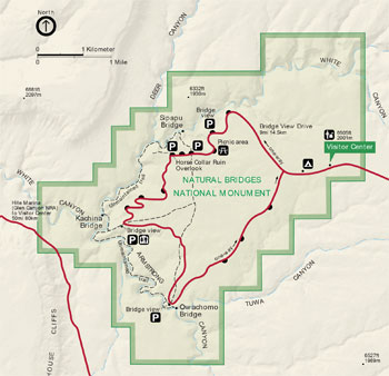
Bridge View Drive Bridge View Drive leads to overlooks and trailheads for all three natural bridges and Horse Collar Ruin archeological site. This paved, one-way loop road is nine miles long. Each overlook and trailhead has limited parking. If towing a trailer or other vehicle, unhook and leave it in the visitor center parking lot.
Hiking Short hiking trails lead from Bridge View Drive to the base of each bridge. Trails along the canyon bottom and on the mesa top connect the bridges and trailheads and offer loop hikes of varied lengths. The park is open year round, but late April through October is its most pleasant season.
Loop Hikes to More than One Bridge
Sipapu | Kachina | Owachomo | |
Sipapu | 0 | 5.6 | 8.6 |
Kachina | 5.6 | 0 | 5.4 |
Owachomo | 8.6 | 5.4 | 0 |
Miles, round-trip, from parking area | |||
Into the Canyon Descending into the canyon you may see hanging gardens in shady alcoves. Shelves and benches occur in canyon walls because rock layers erode at different rates. Mudstone and siltstone erode faster than sandstone, promoting sandstone's collapse, breakup, and removal. This creates the stairstep effect of alternating cliffs and benches from mesa top to canyon floor.
Wildlife Wildlife abounds here, but you may see only birds, rabbits, and lizards. Bobcats, coyotes, bears, mule deer, and mountain lions live in the area but will evade your notice if at all possible.
WARNINGS Watch for sheer drop-offs and unfenced trails and for lightning and flash floods from thunderstorms. Carry at least one gallon of water per person per day. Climbing on bridges is prohibited. Dogs are prohibited on hiking trails; they must be leashed when outside vehicles.
Please stay on trails and do not touch rock art or write on canyon walls or enter structures. Leave all artifacts in place for others to enjoy.
Accessibility We strive to make our facilities, services, and programs accessible to all. For more information go to the visitor center, ask a ranger, call, or check our website.
Source: NPS Brochure (2018)
|
Establishment Natural Bridges National Monument — April 16, 1908 |
For More Information Please Visit The  OFFICIAL NPS WEBSITE |
Documents
A Small Mammal Survey of Natural Bridges National Monument, Utah (Paul J. Nix, Gar W. Workman, Emily C. Oaks and Lou Hendrickx, July 1, 1977)
An Archeological Survey of Natural Bridges National Monument, Southeastern Utah Intermountain Cultural Resources Management Professional Paper No. 64 (Janet L. McVickar, ed., 2001)
An Archeological Survey of the Upper White Canyon Area, Southeastern Utah (Philip M. Hobler, Audrey E. Hobler and Polly Schaafsma, extract from Antiquities Section Selected Papers, Vol. 5 No. 13, 1978, ©Utah State Historical Society)
Annotated Checklist of Vascular Flora, Natural Bridges National Monument NPS Natural Resource Technical Report NPS/NCPN/NRTR-2009-155 (Walter Fertig, January 2009)
Archeological Investigations at Natural Bridges Southwestern Monuments Special Report No. 17 (Charlie Steen, May 1937)
Country of Natural Bridges (H.L.A. Culmer, extract from Technical World Magazine, Vol. 10, 1908)
Cultural Affiliation of Kachina Bridge Ruin (Nancy J. Coulam, extract from Utah Archaeology, Vol. 14 No. 1, 2001, ©Utah Statewide Archaeological Society and the Utah Professional Archaeological Council)
Evaluation of Hanging-Garden Endemic-Plant Monitoring at Southeast Utah Group National Parks, 2013-2020 NPS Natural Resource Report NPS/NCPN/NRR-2022/2473 (Rebecca Weissinger, October 2022)
Fire and Fuels Management Plan (June 2005)
Foundation Document, Natural Bridges National Monument, Utah (August 2013)
Foundation Document Overview, Natural Bridges National Monument, Utah (August 2013)
Geologic Map of Natural Bridges National Monument, Utah (February 2024)
Geologic Resource Evaluation Report, Natural Bridges National Monument NPS Natural Resource Report NPS/NRPC/GRD/NRR-2004/003 (T.L. Thornberry-Ehrlich, September 2004)
Historic Resource Study: Canyonlands National Park, Arches National Park and Natural Bridges National Monument (Western Historical Studies, Inc., Steven F. Mehls and Carol Drake Mehls, July 15, 1986)
Junior Ranger Program, Natural Bridges National Monument (2015; for reference purposes only)
Man's effets on aquatic and riparian organisms in the canyons of Canyonlands and Arches National Parks and Natural Bridges National Monument Final Report — Reporting Period: 1990-1992 (Sandra Mitchell and Bruce Woodward, April 30, 1993)
National Register of Historic Places Nomination Form
Owachomo Bridge Trail (Steven F. Mehls and Carol Drake Mehls, February 15, 1988)
Personal Diary Of H.A. Culmer, 1905 Southwestern Monuments Special Report No. 18 (Henry A. Culmer, June 1937)
Preliminary Report on the White Canyon Area, San Juan County, Utah USGS Circular 217 (W.E. Benson, A.F. Trites, Jr., E.P. Beroni and J.A. Feeger, 1952)
Report on Sullys Hill Park, Casa Grande Ruin; the Muir Woods, Petrified Forest, and Other National Monuments, Including List of Bird Reserves: 1915 (HTML edition) (Secretary of the Interior, 1914)
Report on Wind Cave National Park, Sullys Hill Park, Casa Grande Ruin, Muir Woods, Petrified Forest, and Other National Monuments, Including List of Bird Reserves: 1913 (HTML edition) (Secretary of the Interior, 1914)
Resource Management Plan, Natural Bridges National Monument (1996)
Soil Survey of Natural Bridges National Monument, Utah (2011)
Statement for Management — Natural Bridges National Monument, Utah (January 1987)
Statement for Management — Natural Bridges National Monument, Utah (November 1994)
The Colossal Bridges of Utah (W.W. Dyar, extract from The Century Illustrated Monthly Magazine, Vol. XLVI, May-October 1904)
The Great Natural Bridges of Utah (Byron Cummings, Bulletin of the University of Utah, Vol. III No. 3 Part 1, November 1910)
The Natural Bridges of White Canyon: A Diary of H.L.A. Culmer, 1905 (Charlie R. Steen, extract from Utah Historical Quarterly, Vol. 40 No. 1, 1972; ©Utah State Historical Society)
Vascular Plant Species Discoveries in the Northern Colorado Plateau Network: Update for 2008-2011 NPS Natural Resource Technical Report NPS/NCPN/NRTR-2012/582 (Walter Fertig, Sarah Topp, Mary Moran, Terri Hildebrand, Jeff Ott and Derrick Zobell, May 2012)
Vegetation Classification and Mapping Project Report, Natural Bridges National Monument NPS Natural Resource Report NPS/NCPN/NRTR-2008/077 (Janet Coles, Jim Von Loh, Angela Evenden, Gerald Manis, Gery Wakefield and Aneth Wright, January 2008)
Water Quality Data Analysis and Interpretation for Spring Monitoring Sites, Southeast Utah Group NPS Technical Report NPS/NRWRD/NRTR-96/77 (Barry A. Long and Rebecca A. Smith, August 1996)
nabr/index.htm
Last Updated: 01-Jan-2025