|
National Park Service
Resorts and Recreation: An Historic Theme Study of the New Jersey Heritage Trail Route The Atlantic Shore: Middlesex, Monmouth, Ocean, Burlington, Atlantic, and Cape May Counties |

|
CHAPTER II:
Railroad Resorts
|
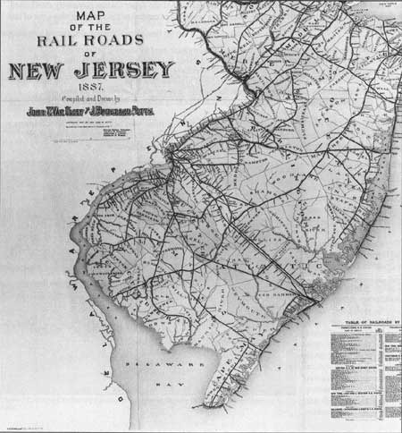
| Figure 19. Map of the Railroads of New Jersey, 1887. Hagley Museum & Library. |
The social democratization described by nineteenth-century authors Frederika Bremer and Olive Logan depended on improvements in transportation. Before the railroad provided an inexpensive and easy way to reach the shore, resort vacations were limited to those who could afford travel and hotel accommodations. Long Branch and Cape May, within a sloop or steamboat ride from major cities, attracted wealthy visitors eager to escape the urban intensity of New York, Philadelphia, or Baltimore. The growth of secular resorts like Atlantic City, created by the railroad, was followed by the founding of coastal religious "camps," such as Ocean Grove and Seaville, which also capitalized on sea breezes, seaside locations, and convenient transportation. Beginning in the 1870s, the railroads brought a new type of tourist to Jersey beaches, the "day-tripper" of limited means. As the social composition of the exclusive resorts began to change, new resorts were established to profit from the influx of middle-class tourists. Throughout the late nineteenth and early twentieth centuries, the railroad created a tourism industry (Fig. 20) that supplemented the local, primarily maritime-based economies of the small towns along shore and bay. In other areas, particularly the Barnegat Peninsula and the neighborhood around Toms River, trains provided the incentive for extensive land speculation. That the resulting new towns catered to a middle-class, suburban population was reflected in the proliferation of comparatively cheap cottages and boardwalk amusements.
|
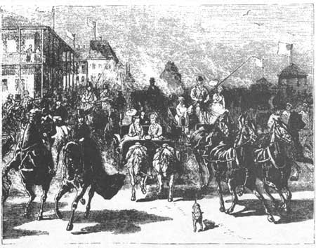
| Figure 20 Ocean Avenue After Arrival of Evening Train Long Branch Harper's Monthly, 1876. |
Traveling from his Camden home to Atlantic City in 1879, Walt Whitman observed the New Jersey landscape from a window on the Camden and Atlantic Railroad:
What a place (is it not indeed the main place?) the railroad plays in modern democratic civilization! How indirectly, but surely, and beyond all other influences to-day in America, it thaws, ploughs up, prepares, and even fructifies the fallows of unnumbered counties and towns!—the tough sward of morals and manners of the low average (nine-tenths) of our vulgar humanity! Silently and surely and on a scale as large and genuine as Nature's, it sets in motion every indirect and many direct means of making a really substantial community—beginning at the bottom, subsoiling as it were—bringing information and light into dark places opening up trade, markets, purchases, newspapers, fashions, visitors, etc. [1]
Whitman's thoughts show how quickly the railroad influenced American life, transforming both the physical and social environment as it pushed across the country. Only twenty-five years before Whitman's observation, the first Camden and Atlantic train roared into a city created for its arrival; twenty-five years later, the automobile would begin to further "democratize" the shore. The similarity between Bremer's thoughts on the social leveling force of the sea and Whitman's description of rail travel describe a shore resort community—and attitudes toward it—that evolved in response to the "iron horse."
Early Railroads
In the 1830s, when shore visitors were still traveling by steamboat and stagecoach, the first New Jersey railroads began to transport goods across the state. Because of its proximity to New York, the Bayshore region (the northern coast between the Raritan and Sandy Hook bays) was a principal point for the transhipment of goods to and from the interior. South Amboy (Fig. 21) was strategically located on a canal route, an ideal terminus for the Camden and Amboy Railroad upon its completion in 1834. Reportedly "the first steam-powered railroad to operate successfully in the United States," [2] the track ran from Camden to the bay. By 1840, the Camden and Amboy owned the Philadelphia and Trenton Railway and had made arrangements with the New Jersey Railroad Company to facilitate the first New York-to-Philadelphia rail connection. [3]
|
| Figure 21. View of Broadway, South Amboy. HABS No, NJ-1001-1. |
At mid century, the Camden and Amboy Company was notorious for its control over rail transportation in the "state of Camden and Amboy." When the New Jersey Central and the Philadelphia and Reading connected to form a competing route between New York and Philadelphia, the two companies entered into a bitter court dispute. The ensuing media battle outraged the public, causing the state to pass a law allowing all railroads to use the tracks. [4] This decision resulted in the creation of the single longest line along the shore, the Delaware and Raritan Bay Railroad; it stretched from Port Monmouth to Camden County, passing through Red Bank, Eatontown and Lakewood, intersecting with the Camden and Atlantic at Winslow Junction. A spur from Eatontown reached Long Branch in 1860 as the railroad pushed its way south. The tracks, constructed to reach valuable Monmouth County marl deposits, were occupied by the New Jersey and Southern Railroad in the 1870s. After extending its line through Vineland and Bridgeton into the Delaware Bay region, the company suffered from financial problems and was forced into a dependent relationship with the Central Railroad of New Jersey. [5]
Atlantic City
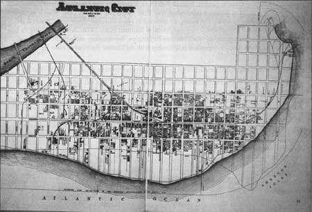
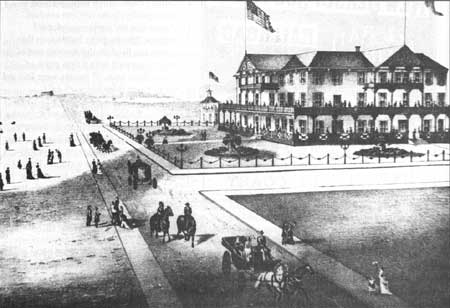
The Camden and Atlantic Railroad obtained a charter for the first rail service to the shore in 1852, before Atlantic City was anything more than a speculator's dream. When Dr. Jonathan Pitney began exploring Absecon Island in the 1830-40s, a single boardinghouse accommodated the area's few adventurous visitors. The climate and location of the land inspired Dr. Pitney to envision a bathing village for wealthy Philadelphians, a scheme encouraged by glass and iron manufacturers as well as railroad investors, who demanded efficient local transportation routes. In 1853, Camden and Atlantic Railroad engineer Richard Osborne laid out city streets, creating a fully planned "paper" city (Fig. 22) by 1854. [6]
Within a year, the Camden and Atlantic Railroad brought a select group of 600 news and businessmen to the United States Hotel, and Atlantic City began its physical and metaphoric growth as a choice resort. The brand-new city thrived on the imagery of excess and pleasure. In his plan of "the first, most popular, most heath-giving and most inviting watering place," Osborne incorporated a sense of nationalism along with an unspoken faith in the city's future prominence. The streets extending from the beach to the inland marshes were named after states, while those running parallel to the ocean took the names of the seven seas. [7]
|
| Figure 22. Plan of Atlantic City, 1877. Winterthur Museum & Library. |
The promise of the railroad inspired entrepreneurs like Thomas Bedloe to build accommodations for thousands of expected guests. Lured by the potential of Osborne's "first" and "most popular" resort, Bedloe came from Philadelphia in 1852 and began constructing the Bedloe House, a hotel he completed in time to greet the first railroad passengers. The history of the United States Hotel, destination of the special inaugural train, illustrates the speculative nature of such early investments. The hotel's first owners, Michener and Neleigh, spent too much on accommodations for the anticipated crowds and were forced to sell the building after only two years. The business fell into the hands of its builders, Philadelphia lumber merchants Brown and Woelepper. Although the hotel required a new Atlantic Avenue wing in the early 1860s, by 1892 the property had passed to "John S. Davis and Elwood Jones, who divided the land into cottage sites and moved the hotel to the Pacific Avenue side of the square. This section was afterwards razed and the land sold as building lots." [8]
The wealth and prominence of the first Victorian hotels is made graphically clear by drawings in Woolman and Rose's 1878 Historical and Biographical Atlas of the New Jersey Coast. In addition to picturing the United States Hotel (Fig. 23), guaranteed notoriety through its connection with the railroad, Woolman depicts the Colonnade House, Haddon House, Seaside House, Germantown Cottage, and several private residences. The city's reputation as a retreat for invalids, with "the proverbial dryness of the atmosphere, and the health invigorating sea breezes is considered by some to rival Florida." [9] Hotels like the Haddon House offered covered porches with views up and down the beach, as well as special basement and parlor heaters providing year-round climate control. Placed in a central location, the hotels were within walking distance of the railroad depot, post office, city hall, and a hot and cold seawater bathing establishment. The Seaside House at the end of Pennsylvania Avenue seemed to sit right on the beach. [10]
|
| Figure 23. United States Hotel, Atlantic City. Historical and Biographical Atlas. 1878. |
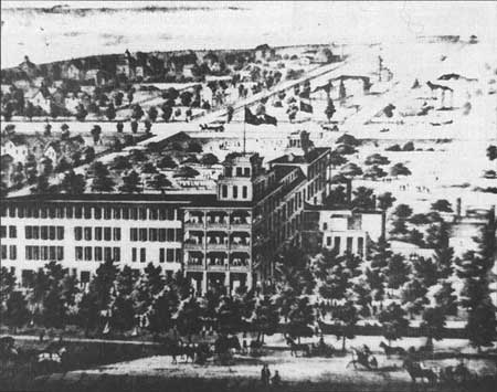
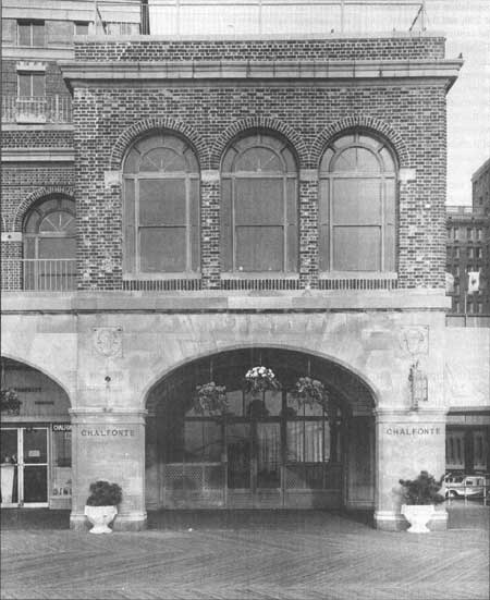
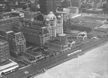
The population of Atlantic City increased dramatically between 1855, when the year-round population was estimated at 250, and the turn of the century, when over 27,000 lived in the resort city. [11] The demand for accommodations was satisfied by the construction of new hotels with hundreds of rooms and the expansion of popular older buildings. The Hotel Dennis grew from a two-room summer house in 1860 to a twenty-two-room lodge in 1867, and a 150-room hotel in 1892. The Chalfonte underwent a similar metamorphosis; the Victorian house built in 1868 was remodeled throughout the century, and emerged, in 1904, as Atlantic City's first iron frame hotel. Shortly after Philadelphia architect Addison Hutton enlarged the Chalfonte (Fig. 24), fellow Philadelphian, William L. Price, embarked on an equally ambitious scheme. Price combined two previously existing buildings, the Marlborough House and the Blenheim House, to form the impressive Marlborough-Blenheim. When it was rebuilt in 1906, the Marlborough-Blenheim (Fig. 25) claimed a place in history as the first hotel in the world composed of reinforced concrete. Thomas Edison, inventor of the new construction method, oversaw the concrete pouring. [12] The hotel was the first to offer private baths in every room—with hot and cold saltwater on tap—modern conveniences it hid behind a dreamlike exterior facade suggesting Far Eastern influence. A reporter for the New Cosmopolis did not know quite how to explain the Marlborough-Blenheim's captivating personality.
If Coleridge, in Kubla Khan, or Poe, the Doman of Arnheim, had described such a fantastic structure we should have understood, for they are men of imagination. The architecture might be Byzantine. It suggests St. Marco's at Venice, St. Sophia at Constantinople, or a Hindu Palace, with its crouching dome, its operatic facade and its two dominating monoliths with blunt tops. [13]
In 1979, a year after legalized gambling offered hope for urban renewal, the hotel was destroyed to make room for casinos.
|
| Figure 24. The Chalfonte Hotel, Atlantic City. Boardwalk Elevation. Library of Congress. |
From its early planning stages, Atlantic City evolved from the need for an efficient transportation system. Increased traffic led to the construction of a second rail line to Camden in 1877; the Philadelphia and Atlantic City's Narrow Gauge was laid down in only ninety-eight days. The West Jersey and Atlantic Railroad Company built tracks connecting Atlantic City with Newfield in 1880. Toward the end of the nineteenth century, tracks stretched across the entire length of the island, linking Atlantic City with the communities of Margate, Ventnor, and Longport. The railroads also operated steamboats from Longport at the extreme south end of the island, to Ocean City and Somers Point. By 1897, the West Jersey route and parts of the South Jersey Pennsylvania lines merged to form the West Jersey and Seashore Railroad Company, owned by the Pennsylvania company. [14]
|
| Figure 25. Marlborough, Blenheim and Dennis, Hotels, Atlantic City. Library of Congress. HABS No. NJ-976. |
South Shore
|
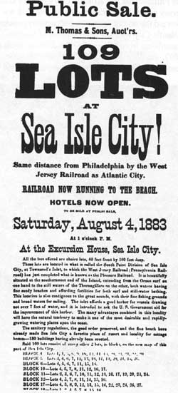
| Figure 26. Notice of Lot Sales, Sea Isle City. 1883. |
The Cape May and Millville Railroad provided inland visitors with the luxury of rail service to beach resorts in 1863. Beginning in 1879, the West Jersey and Seashore Railroad took charge of the Camden and Millville and began working its way up and down the shore. Two years after the Seven Mile Beach Company established Avalon, the company granted the West Jersey Railroad the right to lay tracks the entire length of the island, connecting to the Cape May main line. The tracks were extended into Stone Harbor three years later. [15] By then, the Avalon Hotel, located near Townsend Inlet at the north end of the city, had already been open for a season. The hotel and twelve cottages were the product of the Public railroad's demand for token "model homes" demonstrating projected development. [16]
As early as 1888, just a year after its founding, Avalon attracted "excursions" to its newly opened beaches. The train arrived at the beach and picnic groves of Peermont with thirteen coaches carrying 700 excursionists from Philadelphia. During the summer season, the daily excursion train always had two engines and about twelve cars. On the weekends, trains with fifteen to seventeen cars, pulled by two or three engines, came into the island's five stations and unloaded 4,000 to 5,000 revelers at Avalon's picnic groves, beaches, and rustic dunes. Speculators often bought and sold lots during such excursions. [17]
Just above Avalon, the stretch of land that would become Sea Isle City awaited the arrival of the West Jersey and Seashore Railroad. The island was relatively unpopulated, with only a few "beach houses," two lifesaving stations, and a lighthouse, before speculators encouraged further building. Charles Landis, founder of Vineland, Cumberland County, purchased Ludlam Island in 1880 and began planning Sea Isle City. He envisioned a town patterned after Venice, complete with canals and classical statuary, accentuating the community's maritime setting. [18] Although Landis' plan was never realized, the Sea Isle City Improvement Company was able to attract a substantial population. An 1881 map of "Sea Isle City, Ludlam Island, New Jersey" advertising 5,405 surveyed lots (Fig. 26), shows that most of the beachfront property, and even inland lots along Railroad Avenue had already been purchased. [19]
The Ocean City Railroad Company provided the first rail service to Sea Isle in 1882 with its 4.8-mile spur from the West Jersey Railroad's main Cape May line. During the 1890s, the Ocean City Railroad Company was absorbed by the West Jersey and Seashore and the South Jersey Railroad, which offered service from Philadelphia through Winslow Junction. Chief engineer H. Farrand's report on the property suggested a profitable future.
With proper railroad facilities, and lots offered at a reasonable price, I do not see why this place should not become as great a resort as Atlantic City, by reason of its proximity to Philadelphia, and the character of the beach . . . The West Jersey Railroad can make the same time to Sea Isle City from Philadelphia, as to Atlantic City. [20]
Though Sea Isle never reached Atlantic City proportions, the proliferation of local hotels throughout the 1880s-1890s illustrates a significant resort trade (Fig. 27). One of the earliest, the Excursion House, was built by the Landis' company in 1882. Complete with stores, a skating rink, and public second-floor terrace, the Excursion House formed the social center of the growing town. By 1889, the Continental Hotel assumed this role, at least in terms of size and fashion. One of the largest hotels on the shore, the Continental's five stories were reached by the only steam-operated elevator in Cape May County. [21] An 1897 history of the area reported thirty hotels, all with electricity and good water. [22] According to one historian, Sea Isle City was the first shore resort to provide "Excursion Houses" for itinerant "Shoobies," visitors who arrived for the day with lunches packed in shoe boxes. Like the famous Excursion House Hotel, these "grandstands facing the beach" provided places for various social events and spectacles, such as horse racing. [23] Beginning in 1905, Sea Isle City residents could join the newly formed Sea Isle Yacht and Motor Club. [24] A decade later, the trolley line running parallel to the sea became a wide avenue, extending through Strathmere to Ocean City on the north and to Avalon on the south.
|
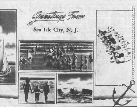
| Figure 27. "Greetings from Sea Isle City." Postcard. ca. 1942. Allaback. |
The West Jersey Railroad's decision to connect Sea Isle City with Ocean City in 1884 resulted in the development of the northern section of the island. Though the city of Strathmere was not officially named until 1912, its history as a resort dates back to the 1870s. The Whelen Hotel was built in 1871 to house Pennsylvania Railroad workers and adventurous fishermen. [25] Then known as Corson's Inlet, the area was called Whale Beach when the first boardwalk was constructed in 1911. Throughout the twentieth century, both Sea Isle City and Strathmere have suffered from the effects of coastal storms. Sea Isle's recoveries from the three severe storms between 1944 and 1962 earned it the nickname "the city that refuses to quit." [26] A 1911 hurricane washed away the foundations of homes and flooded most of the island, reminding late season residents of the constant threat to their resort-based economy.
Barnegat Bay
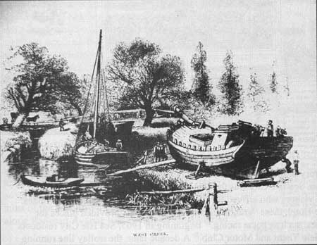
While nineteenth- and early twentieth-century guidebooks speak of most shore resorts as individual cities, the mainland towns from Toms River to Tuckerton are often subsumed under the title "Barnegat Bay resorts." Traffic between New York and Long Branch generated Monmouth County railroad lines, but the shipbuilding and charcoal industries at Toms River and Tuckerton were responsible for Ocean County rail development. The bay towns of Forked River, Waretown, and Barnegat were established communities relying on the products of forest and sea long before the railroad brought resort trade; sportsmen traveling to Tucker's Inn and other area hotels discovered small settlements, not freshly surveyed lots awaiting trainloads of prospective buyers. A year before Kobbe wrote about the Barnegat Bay resorts, a correspondent for Harper's New Monthly Magazine visited West Creek (Fig. 28) and noted that "the traveller who finds it in his time-tables is quite sure not to make the mistake of supposing that it is much of a town, or a mushroom outcome of a real estate speculation." [27] The Harper's reporter bypassed the "inducements" of Long Branch to continue down the coast "in search of the picturesque" aboard the New Jersey Southern Railroad. After transferring to the Tuckerton Railroad (Fig. 29) at Whitings, the reporter and his artist friend traveled to the little village of West Creek between Manahawkin and Tuckerton. A town of fishermen, farmers, and boat-builders who took on other tasks, such as harvesting salt hay and ice when the season permitted, West Creek exemplified the varied economic base characteristic of most Barnegat Bay communities. [28] The railroad provided new markets for oysters, clams, and other products formerly transported over poor roads in wagons. Though bay towns profited from a tourist trade as a result of improved access, locals were more interested in shipping opportunities.
|
| Figure 28. West Creek. Harper's Monthly. 1878. |
|
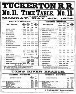
| Figure 29. Tuckerton Railroad Schedule. 1874. |
After discussing the bay's geographical features and the "pirates of Barnegat," Gustav Kobbe reaches the conclusion that "Barnegat Bay is all sport." [29] His account of the rivalry between Forked River, Barnegat, and Waretown for the title of best fishing and gunning grounds describes a different kind of seasonal resort traffic. Fishermen who visited the area throughout the summer marveled over the large numbers of weakfish, sheepshead, and kingfish, while the gunners arriving in the winter and spring expected a plentiful supply of teal, broad-bills, blacks, red-heads, and other birds. The quail, rabbit, raccoon, and fox frequenting the woods were also fair game. Waretown earns Kobbe's highest rating as a fishing ground because of a convenient point of land extending from the salt marsh to the shore within easy access of the railroad station. "Nevertheless, among sportsmen Forked River is considered the fishing headquarters for Barnegat Bay, and Barnegat the headquarters for gunning." According to Kobbe, this preference for Forked River was based on the town hotel, the Lafayette House, run by Sheriff Parker. Not only did the Lafayette offer a plentiful supply of food at early hours, but also quick, efficient stage transportation directly from boat to hotel. Barnegat's favorable situation was based purely on geographical location, its proximity to the chief "shooting points" of Lovelady and Sandy Islands. Low cost was the final incentive in Kobbe's promotion of the area. His list of prices for rental boats, bait, and gunning privileges indicates a well-organized sporting "industry" along the bay in 1889. [30]
Although the Tuckerton Railroad, like the Camden and Amboy, was organized by merchants eager to transport local goods inland, it also promoted resort development. Completed in 1871, the line extended from the Pennsylvania connection at Whitings to Tuckerton, passing through Bamber, Barnegat, Manahawkin, West Creek, and Parkertown. [31] Writing shortly after the Tuckerton Railroad began laying tracks along the shore, Woolman assured his readers that "doubtless the time is not far off when the entire New Jersey shore, from Sandy Hook to Tuckerton, a distance of about 90 miles, will be thickly studded with hotels and cottages, thus affording delightful and healthful resorts to a vast multitude, who in summer abandon the stifling air of our cities and inland towns for the pure atmosphere of the seashore." [32] Within a matter of decades, his prediction would become reality.
A 1920 brochure of the Central Committee of the Barnegat Bay Boards of Trade focused on the area around Toms River. The advertisement promoted the strategic location of the town, exactly between New York and Philadelphia and at the crossing of the Pennsylvania and Jersey Central railroads, and its convenient bay access. The following description is typical of the promotional literature published in the late nineteenth and early twentieth centuries, particularly by railroad companies with stations in established resorts:
Toms River has a tang of its own—no other place is quite like it; no other village can take its place; and to those who have once tasted the joys of Toms River and Barnegat Bay, the attractions of the ordinary summer resort are insipid and flat. One season at Toms River remodels a man's ideas of sport and recreation, and two seasons makes Toms River a habit that lasts as long as life itself. [33]
The brochure also lists the healthful benefits of vacations in Island Heights, Seaside Heights, and Seaside Park. Particularly apparent is the emphasis placed on the select group of visitors allowed to enjoy the area. Distinguishing the bay-area towns from those populated by "excursionists," the brochure responds to the growth and corresponding "democratization" of other Jersey resorts such as Long Branch and Atlantic City. Such direct comments on the social composition of the area may have reflected the recent development along the south side of Toms River, primarily the work of speculators from New York and Philadelphia. The Pennsylvania and Long Branch Railroad, which began service to the area in 1881, made the land more appealing to investors, and two years later, Island Heights was popular enough to require a branch line.
North Shore
The Long Branch and Sea-Shore Railroad began building down the coast in 1863, reaching Long Branch two years later on tracks "so close to the ocean beach in some places that the surf blends with the rattle of the cars and the shriek of the locomotive whistle; and at times in high tides, the waves have washed over the track." [34] A little over a decade later, trains were running from Long Branch to Sea Girt and Manasquan in Monmouth County. Meanwhile, the New Jersey and Long Branch Railroad worked its way southward. In 1882, tracks ran from Sandy Hook to Bay Head, where connections were made with the Philadelphia and Camden line of the Pennsylvania Railroad. Traffic along the rails was intense because the New Jersey Southern and Pennsylvania ran on Long Branch and New York tracks. Comparing transportation by mail stage ten years earlier to modern rail travel, an Asbury Park journalist reported that "today fifty-five trains arrive at our station in each twenty-four hours, and all are well loaded." [35] By 1896, reporters announced that "one day last week 776 coaches were used on the New York and Long Branch railroad in transporting people to the seashore. It took twenty-one cars just to carry the baggage away." [36]
|
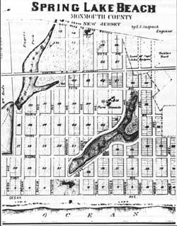
| Figure 30. Spring Lake Beach Plan. Historical & Biographical Atlas. 1878. |
During the 1870s-80s, the arrival of the railroad opened southern Monmouth County to more extensive resort growth. Spring Lake represents the type of land speculation that preceded the railroad. Spring Lake (Fig. 30) was originally four distinct shore communities: Brighton and North Brighton, Villa Park, Spring Lake Beach (named for the fresh-water pond its streets enclosed), and Como, at the north end of the tract. Each settlement grew from one or two large farms into a village centered around a hotel and a railroad station. Undeveloped under a string of owners from the 1760s, the land was subdivided, sold off, and built up during a relatively short time in the last quarter of the nineteenth century. The farmland, dunes, and forests adjacent to the Atlantic Ocean between Lake Como on the north, and Wreck Pond to the south, became an urban grid pattern of streets. In 1872, William Reid and John Rodgers, owners of a prominent stagecoach business, foresaw that their enterprise would be rendered obsolete by the coming railroad and converted their farm near Wreck Pond into Rodger's Villa Park and Reid's Villa Park, which were later combined into a single Villa Park. [37]
In 1873 Joseph Tuttle and William Reid subdivided the Walling Farm and established building lots for the future resort of Brighton. The development of the adjacent Spring Lake Beach area in 1874 followed the founding of the "Villa Parks" and Brighton. Philadelphia fisherman and clergyman Dr. Alfonso A. Willits found the area particularly to his liking and decided to purchase the farmland, developing it into a resort property for wealthy Philadelphians. With the backing of the railroad and members of the Sea Girt Land Association, Willits formed the Spring Lake Beach Improvement Company. Philadelphia engineer Frederick Anspach designed a town plan around the Monmouth House Hotel. [38] The elegant building was "233' long, four stories high, with 270 bedrooms, a dining room seating 1,000 guests, and two large parlors overlooking the ocean." [39] It offered modern amenities such as steam-powered elevators and "electric calls" in every room. [40] Guests visiting the hotel when it opened in 1876 were equipped with boats for restful cruises on the lake and shuttled to and from the railroad station in horse-drawn omnibuses. [41]
Publications, such as Camden's New Jersey Coast Pilot, "a journal devoted to the development and advancement of the interests of the coast region of the state," were a forum for promotion by the "land associations" or development companies. Spring Lake entrepreneurs financed the construction of houses to manage as vacation properties. W.C. Hamilton built the five Victorian cottages pictured in Woolman and Rose's Atlas on romantic tree-filled sites. They mirrored the taste of the times, if not the sandy reality of the beachfront. [42]
By the 1880s, the railroad entrepreneurs reached Barnegat Peninsula, building railways running much of its length, and linking it to the mainland at Point Pleasant to the north and from Seaside Park via trestle eastward to Coates Point at the mouth of Toms River. Anticipating the construction of Central Railroad tracks across the river, businessmen built the Ocean House along the single road to Point Pleasant Beach. The future city's strategic railroad location at the junction of the major New York and Philadelphia lines made it the ideal location for resort development. Speculators began eyeing the area as early as the 1850s, with at least one unsuccessful attempt to subdivide the undeveloped beach lands into one-acre lots. [43] By 1866, the Oceanfront Land Company bought a bankrupt farm along the Manasquan River. John Arnold, a local sea captain, developed another tract of land named "Arnold City" in three hundred lots measuring 50' x 100'; he included the Atlantic View Cemetery for "the benefit" of his buyers. [44] Three years before the railroad arrived in 1881, Trenton investors organized the Point Pleasant Land Company, planned Point Pleasant City and built the Resort House Hotel. [45] The company laid out streets "in a grid-like Philadelphia plan for easy sales," [46] with lots on both sides of the railroad tracks, reaching all the way to the Atlantic Ocean. By 1890, Edwin Salter could report that "eighteen or twenty years ago Point Pleasant was an unimproved, undeveloped tract. [It] is now seen in fine cottages, schools, churches, stores, hotels and boardinghouses standing on well laid-out streets and avenues, where formerly rabbits and reptiles were want to burrow." [47] An estimated 4,000 to 5,000 summer visitors entertained themselves with promenades along the boardwalk (Fig. 31) and across an iron bridge "lighted with electricity." Point Pleasant's range of accommodations, from hotel rooms at the Resort House to summer cottages for rent each season, rapidly made it one of the most popular summer resorts on the Jersey coast for New Yorkers and Philadelphians. The trolley line between Point Pleasant and Bay Head was completed in 1894, an early sign that the two communities would merge into a continuous settlement. [48]
|
| Figure 31. Boardwalk, Point Pleasant Beach, HABS No. NJ-1012-2. |
Captain Arnold illustrated his faith in the railroad by founding the village of Mantoloking. Bay Head, just south of the point, also became an attractive resort possibility during the 1880s. Though the Central Railroad hesitated to push forward, possibly because of the problems its New York and Long Branch line suffered along the narrow Sea Bright Peninsula, it was encouraged to proceed by the establishment of a Pennsylvania Railroad line. In 1880, a group of visionary Philadelphians convinced of the resort's financial potential, supported the railroad company's line from Pemberton to the shore. [49] Roads were built, with bridges to the mainland, and in the twentieth century, new hamlets filled every inch of land among the towns and even crept out onto Barnegat Bay islands that barely rise above the water line. In the process of this rapid development, much of the natural landscape that initially inspired settlement has disappeared.
Bay Head, at the head of Barnegat Bay, was founded by a triumvirate of Princeton bankers. "The big three rode into town on a summer day in 1877," finding dunes, tall grasses, a pond, the bay, bushes, meadows, marshes, and "the smell of the sea." [50] Edward Howe, William Harris, and David Mount apparently saw opportunity, too, for they bought 45 acres from Capt. Elijah Chadwick and founded the Bay Head Land Company in 1879. [51] The Bellevue Hotel, the first of five big hotels, accommodated visitors by 1881, when the New York and Long Branch Railroad was extended to Bay Head from Manasquan on the north. The Pennsylvania also opened its line from Seaside Park, which connected via trestle to the mainland. Before the new bridge, all supplies had arrived by boat. Almost immediately after the crossing was completed, wood-shingled summer homes were erected along the beach and private estates appeared on the shore of Barnegat Bay. [52]
Bay Head managed to attract the genteel clientele desired (Princeton University faculty and founding bankers) with lots sold under deeds prohibiting everything from beer to slaughterhouses. [53] Evidence of this exclusivity is still visible today, both in street names remembering Princeton professors [54] and rows of well-preserved houses. "Houses at Deal and Elberon or Margate may be bigger and brighter and more costly," says one Jersey Shore chronicler, "but the Bay Head-Mantoloking homes, set comfortably in reasonably well-preserved dunes, are like the etchings of seaside 'cottages' in Harper's Magazine. There is unshowey evidence of wealth, of conservativism—the expensive 'natural' look, the 'Ivy League' look, so to speak." [55]
A contrasting but perhaps fictitious side of Bay Head was recorded in the novel 1919, part of John Dos Passos' trilogy USA. Richard Ellsworth Savage, one of the book's multitude of shallow characters, comes of age working in a local hotel. Savage discovers Christianity at St. Mary-by-the-Sea Church, meanwhile getting involved with the church minister's wife, whom he sees every Sunday night when the minister goes off to preach in Elberon. [56] Dos Passos himself, who apparently visited in 1918, recorded a sunnier outlook in his diary: "Could anything be stranger than the contrast between Bay Head—the little square houses in rows (Fig. 32), the drugstores, the boardwalks, the gawky angular smiling existence of an American summer resort—and my life for the last year. Hurrah for contrast." [57] In Bay Head several stores and an Applegate's Garage opened to serve the locals, but no substantial business district developed, and residents were forced to bring staples from Point Pleasant. The city was connected to Bay Head by a streetcar that ran in the summer between 1903 and 1919. [58]
|
| Figure 32. Elmer Cottage, Bay Head HABS No. NJ-1099-1. |
Mantoloking, adjoining Bay Head to the south, is the name of uncertain Indian origin given to a ritzy seaside summer cottage community planned by New York real estate promoters. Frederick W. Downer began assembling land in 1875, for what was to become a resort based, not on lodging, but ownership. [59] John Arnold organized the Sea-Shore Land and Improvement Company in 1878 and began selling lots for the future city. To attract wealthy buyers, he imported topsoil and offered, on this parched, windswept sliver of land, the possibility of luxurious lawns. [60] Rather than locate a public boardwalk or a street directly at the ocean, as in more populist beach communities like Ocean Grove, the choicest lots were fronted to give privileged buyers the beach and view all to themselves. The large number of shingled mansions still standing, such as 1237 Ocean Avenue, perhaps testify to the success of this formula; some people built cottages complete with carriagehouses, as at 1233 Bay Avenue. [61]
The history of Lavallette parallels that of Mantoloking and Bay Head farther north, having been opened by a land "improvement" company in the 1880s and prospering with the coming of the railroad. It also benefitted from a growth of leisure time in America among the classes to whom it catered—doctors, lawyers, and successful businessmen who, by the 1880s, could afford to buy or build summer homes (Fig. 33) and take time off from work to spend at them. [62] One local builder was Capt. McCormick. [63] Peter Bloom advertised himself as "pioneer carpenter and builder" in 1937. [64] Fire and demolition have destroyed many early buildings, and the automobile has brought a blighted, worn appearance to the city's main street, Grand Central Avenue. "There is little if any discernible concern for preservation in the town," according to the report on Lavallette in the historic sites study of Ocean County. [65] Despite this laissez-faire attitude toward history, much of old Lavallette remains; of particular interest are the Lavallette Hotel on Grand Central Avenue and the Lavallette Theater to the south, whose stucco alterations suggest an effort to streamline and modernize. [66]
|
| Figure 33. Wood-shingled Houses, Lavellete. Photo by Alfred Holden. |
Between 1875 and 1880, the railroad began bringing visitors to the shore communities south of Ocean Grove and Bradley Beach. Speculators anticipating opportunities for land development "followed the tracks" down the shore to Ocean Beach, now known as Belmar. [67] The founders, originally from Ocean Grove, predicted that people would want to move up to larger, more luxurious homes on the Jersey Shore. [68] For $100,172.50 they bought what amounted to a 372-acre peninsula of land bounded by a mile of Atlantic Ocean on the east, and a mile-and-a-half of the lake and inlet formed by the Shark River on the north and west. [69] Operating first as the Pleasant Beach Association and later as the Ocean Beach Association, the founders employed the typical superlatives to entice prospective buyers. "This tract is considered the finest location on the Atlantic Coast, for a summer resort one of the most beautiful landscapes imaginable." [70] In 1875, the 2-year-old Ocean Beach Association advertised half-price lots for hotel builders. The following year, a stage line was established between Ocean Grove and Ocean Beach and a promotional auction was held during one of Ocean Grove's camp meetings to sell lots in the new community. Potential investors traveled on excursion tickets from cities along the Pennsylvania line, which added extra cars for travel to the auction from Philadelphia. The successful scheme resulted in the sale of 135 lots and a record number of passengers aboard the Pennsylvania Railroad, [71] By 1878, Ocean Beach entertained the patrons of five hotels: Riverview House, Colorado House, Neptune House (Fig. 34), Fifth Avenue House, and Columbia House. [72] Twelve 80'-wide avenues were laid out perpendicular to the shore, each block being divided into 50' x 150' lots. Depending on location, these were sold for $300 to $1,500 with deeds requiring buyers to build cottages. [73]
|
| Figure 34. Neptune House, Ocean Beach. Historical and Biographical Atlas, 1878. |
In 1908, another land auction was held for undeveloped property between Belmar and Spring Lake, the future site of South Belmar. [74] The Ocean Grove Park Association occupied offices in Steinbach's Department store in Asbury Park while holding drawings for pianos, tea sets, opera glasses, diamonds, watches, silverware, and ice cream makers to draw crowds before each day's auction that August. The Atlantic Coast Electric Railroad ran streetcars from Asbury Park every five minutes, and prophetically, automobiles brought people over from the railroad station. [75] For a time, the new development was called Ocean Grove Park, perhaps strategically; however, one account claims that the name was adopted because "the property borders on the ocean and because the western end of the tract is covered with a fine grove of Jersey Pine trees." [76] Streets were laid out on an angle from Belmar's grid.
|
| Figure 35. Label from the Central Railroad of New Jersey. Hagley Museum & Library. |
Kobbe's guidebook explains the shore railroads' complicated history of name changes, mergers and spurs while providing commentary on the scenic view from a train-car window. The Central Railroad of New Jersey (Fig. 35) is preferred over the Pennsylvania line because, "from the start it follows the shore, so that its passengers enjoy many beautiful water views between Jersey City and Perth Amboy." [77] The Central Railroad's Sandy Hook route is an "exhilarating recreation" in itself. As improvements were made in train cars and lines began to compete for the growing number of shore visitors, rail travel became the first stage of a resort vacation, rather than merely the means of transportation.
The Central Railroad's own "Travelers and Tourists Guide to the Seashore, Lakes, and Mountains" promoted extensive shore service and a "comfortable ride on a soft-cushioned seat." [78] The introduction to the Central Railroad guide commented on a new kind of literature developing from early reference directories—the company's annual promotional book. Considered a literary "work of art," the guide described the railroad's effort to attract a particular clientele. The company was particularly proud of its much-lauded Sandy Hook route extending from Atlantic Highlands to Point Pleasant. "This Water and-Rail route is the most delightful way of reaching the seashore, and is generously patronized during the summer months by businessmen and others who sojourn on the coast. It is a favorite with many who appreciate a beautiful sail that is absolutely free from the patronage of objectionable people." [79] A second Central Railroad book, Along the Shore and in the Foothills of 1910, appealed to the successful businessman who might prefer a suburban environment to the noise and hassle of urban life. The railroad hoped that its praise of the family values cultivated in suburbia would increase commuter traffic as well as tourist patronage. [80]
Long Beach Island
Woolman did not foresee the potential of settlement along a second piece of "shore" in the middle of the Bay—Long Beach Island. In the early 1880s, residents of Long Beach Island prepared for one of the most dramatic structures to support the shore railroad. The new timber trestle bridge from Manahawkin Meadow to Barnegat City was ready for use in July 1886. Along with the inevitable tourists, the railroad brought loads of gravel for filling in the marshy parts of the island. A spur of the main track ran into nearby Cedar Run, where gravel pits were located in the vicinity of Route 9 and Green Street. The gravel and other supplies passed through the main part of Manahawkin on their way to the island. [81] Ironically, the seeds and grasses from the gravel polluted the island's much touted "pollen-free" environment. [82] Although the Tuckerton Railroad managed the island strip, the Pennsylvania Railroad owned the line that stopped at Barnegat City Junction before heading to Barnegat City (now Barnegat Light) or south toward Beach Haven. The railroad operated until 1935, when dwindling ridership resulting from the new automobile causeway made the necessary bridge repairs too expensive.
By the time the Tuckerton Railroad arrived from Manahawkin in 1886, Beach Haven Yacht Club, Holy Innocents Episcopal Church (Fig. 36), and several new hotels were waiting. According to the New Jersey Courier, the railroad would end the "risk of life upon the ice in mid winter in order to go and come to this old isle of the sea." [83] Up until then, travel to the island had been unpredictable and often dangerous. The security of rail transportation brought continued growth at an even faster pace. In the 1880s and 1890s, more homes were built in the residential area between Bay and Atlantic avenues; many of these Victorian cottages are still standing (Fig. 37). Residents and visitors could play tennis at the yacht club, enter boat races, and participate in events sponsored by the Corinthian Gun Club. Long Beach City (present-day Surf City) grew from out of "the Great Swamp" in 1873, and the extreme north end of the island became Barnegat City in 1881.
|
| Figure 36. Holy Innocents Episcopal Church, Beach Haven, Long Beach Island. HABS No. NJ-1102-1. |
|
| Figure 37. Pharo House, Beach Haven, Long Beach Island. HABS No. NJ-1103-1. |
Convenient, inexpensive rail transportation also bolstered the island's maritime industries, increasing profits from point fisheries at Ship Bottom, and salt-hay and seaweed harvesting. [84] In the 1920s, the Barnegat docks were the site of the first cooperative fishery in America. By 1936, commercial fishing centered around five fisheries—Barnegat City Fishery, Surf City Fishery, Ship Bottom Pound Fisheries, Crest Fishery, and Beach Haven Fish Company. Using boats made on the island, the fishermen pulled in between 6 and 10 million pounds of fish every year. [85] Today, evidence of these early fisheries exists only in the form of docks and sheds at Barnegat Light and Beach Haven. Fishermen share the area with local artists who have converted some of the buildings into Viking Village (Fig. 38), a group of shops and studios. [86]
|
| Figure 38. Viking Village, Barnegat Light, Holden. |
The Trolly
Once tourists arrived at the shore, a different kind of rail provided local transportation. The first electric street railway, constructed in 1887, began at the Asbury Park railroad station and over the next decade traveled north to Deal Lake and south to Avon-by-the-Sea. [87] Residents of Avon welcomed the trolley with a "Railway Greeting" composed for the occasion. "Loud the song of jubilee/Together let us sing/For the march of progress/Like a bird upon the wing/Onward comes the rail car/Electricity is king/Hip, hip hurrah for the railway!" [88] Despite early wiring problems, the Sea Shore Electric Railroad managed to improve its system and set the example for future street-car companies. In 1895, the Sea Shore bought the West End and Long Branch Street Railroad horse-car line and renamed it the Atlantic Coast Electric Railroad. The double-tracked electric line was extended to the Shrewsbury River, where passengers could catch steamboats for New York. [89] A 1908 "Souvenir Book" promoting Monmouth County guaranteed that "the shore can be reached by trolley from any part of the state, Trenton, Newark, Jersey City, and New York City." The brochure assures passengers of "convenient" and "pleasant trolley trips" to all the popular coastal destinations from inland Jersey and New York. [90]
|
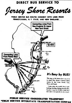
| Figure 39. Shore Resort Bus Service. Sun Fun in New Jersey, ca. 1927. Cape May County Historical & Genealogical Society. |
Though the Central Railroad promised otherwise, in 1910, the railroad was neither free from "objectionables" nor the driving force behind suburban development. The company must have anticipated competition with the automobile, already motoring down roads parallel to the tracks. In the 1920s, the Jersey Central's Jersey City-Atlantic City line offered its response to the threat of vehicular transportation. Suffering from low patronage, the railroad remodeled two engines, painted thirteen cars blue and cream, reupholstered the coach furniture in blue mohair, and provided special meals and other services. Beginning February 21, 1929, the Blue Comet blazed a trail between Jersey City and Atlantic City twice a day. "The 136-mile route ran by way of Elizabethport, Red Bank, Lakehurst, Winslow Junction, and then on to the high-speed Reading Company's Atlantic City Railroad for the final lap to the shore." [91] In 1933, the train's West Jersey rails were incorporated into the recently consolidated Reading and Pennsylvania Railroad. The Comet's luxury travel accommodations were popular in the early 1930s, but by 1939 the company could no longer compete with the growing popularity of automobile travel. The Comet became a shooting star in 1941 when train buffs boarded its cars for a final commemorative trip from Atlantic City.
The 1964-65 Almanac emphasized the "bridge character" of New Jersey railroads by noting that "only 9 percent of the trackage companies serving New Jersey lies within the state, while over 90 percent lies in other states between the Atlantic Seaboard and the Midwest." [92] In the 1960s, the Pennsylvania—the nation's most extensive rail system—offered lines to Sea Girt and Seaside Park, along with its more popular New York and Philadelphia connections. [93] Today, New Jersey Transit provides the only shore rail service, a single line from Jersey City to Bayhead. New Jersey Transit supplements its railroad with bus lines from selected shore stations (Fig. 39) and a variety of special-destination buses from New York, such as the bus to Great Adventure Amusement Park in Ocean County, the Monmouth Park Pony Express from Penn Station to Monmouth Park, and the Victorian Express to Cape May. Advertising itself as an alternative to "the aggravation of driving," New Jersey Transit Authority's "fast, cool and comfortable alternative" continues the long tradition of public transportation to Jersey resorts. [94]
Cape May
By 1834, Cape May, located at the southernmost tip of the state, was already "a noted and much frequented watering place." [21] Almost 150 years earlier, New Haven and Long Island whalers settled the area, beginning a tradition of maritime activity that continues today. The road built in 1796, "along which boats might be stowed," contributed to the growth of the hamlet, a village with "clean and grassy streets" by 1829. [22] Resort and maritime trade grew simultaneously; the sloops carrying wealthy Philadelphians to the resort in 1815 passed fishing boats on their way to the island. Early Cape May County industries included lumbering, oystering, clamming, and fishing, but, even at this early date, "a considerable revenue" was "derived from the tourists who visit the seashore during the hot weather." [23]
Cape May's "transportation monopoly" is the best explanation for its rapid rise as a particularly attractive shore resort. [24] As early as 1800, Philadelphia newspapers lured potential visitors with descriptions of the sea, maritime resources, and travel options. Ellis Hughes' article in the June 1801 Philadelphia Daily Aurora is preoccupied with stagecoach arrangements (Fig. 9), and illustrates the uncertain and time-consuming travel conditions before regular railroad service. [25] A letter describing an 1823 visit to Cape May included three pages devoted to the steamboat journey. [26] Upon arrival at Cape May, the author recorded a series of "taverns" waiting for guests: the Upper House, the Large House, and the Lower House. The author recommends the third establishment to invalids because of its proximity to the surf and sea breezes. [27]
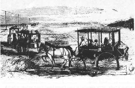
|
| Figure 9. Wide-wheeled Beach Carriages Crossing the Marsh. Frank Leslie's Illustrated Magazine. 22 August 1857. |
Before the completion of the railroad to Atlantic City, Cape May's location—the meeting point of the Atlantic Ocean and Delaware Bay—provided the advantage of easy sloop rides down the river and convenient access to the shore from Philadelphia, Baltimore, and New York City. An 1877 brochure advertising the West Jersey Railroad describes the "annual pilgrimage" to the Cape in terms of transportation improvements. "Down through succeeding years—the stagecoach finally [gave] way in an unequal contest with the innovating steamboat to carry the increasing crowds of seekers after health, recreation, and enjoyment, and the boat in turn succumb[ed] to the locomotive engine." [28]
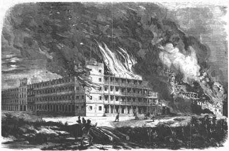
The 1850s marked a turning point in the urban development of the island; the town was incorporated in 1851 after an extensive street survey. [29] Gradually the resort gained notoriety as a place for recreation as well as health, and the first summer cottages were constructed. Building proceeded on a grand scale, as it would over the succeeding decades. Thomas Ustick Walter, architect of the U.S. Capitol, was commissioned to enlarge the Columbia House. [30] An 1856 fire burned the Mount Vernon (Fig. 10), then the largest hotel in the world, just two years after the Camden and Atlantic Railroad to Atlantic City ended Cape May's "transportation monopoly." Despite these setbacks, the city continued to grow in anticipation of its own railroad, the Cape May and Millville.
|
| Figure 10. Mount Vernon Hotel Fire, Cape May. Frank Leslie's Illustrated Newspaper. 20 September 1856. |
Among the many Philadelphians banking on the trains' success, were John Bullitt and Frederick Fairthome who purchased the Columbia House in 1863. [31] They changed the architectural future of Cape May by hiring Philadelphia architect Stephen D. Button to remodel the hotel and add a summer house. Over the next thirty years, Button designed nearly forty buildings representing a range of local architectural types and styles, from simple cottages to classy hotels. The elaborate John McCreary Villa (Fig. 11) at Columbia and Guerney, the row of seemingly mass-produced Victorian cottages built down the street in 1871-72, and the sprawling Windsor Hotel, constructed seven years later at Windsor and Beach avenues, are Button's creations.
|
| Figure 11. John B. McCreary House, Cape May. Library of Congress. |
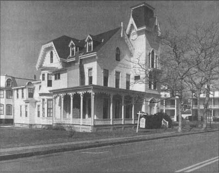
Although the Italianate villa on Washington Street is sometimes attributed to Button, it closely resembles a design Samuel Sloan published in The Model Architect. [32] Books like Sloan's, with easily modified patterns, were the inspiration behind many "anonymous" Cape May Victorian homes. In contrast, the Emlen Physick estate attributed to well-known Philadelphia architect Frank Furness is "of a design different from any other in Cape May." [33] The house is surrounded by various out-buildings including a carriagehouse, dovecote, and school. The Physick House, today occupied by the Mid-Atlantic Center for the Arts, overlooks a tennis court in a neighborhood of year-round homes.
Atlantic City and other shore resorts depended on the railroad for development, but Cape May waited for decades before West Jersey Railroad trains finally began to arrive. The company's 1877 promotional booklet describes the trip from Philadelphia across New Jersey to the Cape May depot. Visitors were greeted by "drivers or attendants vociferating the names of all the hotels at the Cape." [34] Along the ocean front, those driving to their hotels could not miss the L-shaped Congress Hall, with its hot seawater bathing pool and 1,000' long ocean pier. The hotels offering sea breezes and views (the Ocean House, Centre House, Atlantic, Columbia, Marine Villa, and others) were most desirable, but also most expensive. A large number of smaller hotels and boardinghouses were hidden away in "the shady city" just a short walk from the beach. [35] Washington Street was the primary shopping district, running from the Congress to Schellinger's Landing on Cape Island Creek, parallel to the ocean. As early as 1877, it included the post office and churches, as well as many stores. The guide considered both Washington Street and Lafayette, the street paralleling it a block to the north, "the principal interior avenues of the city." [36]
In 1878, a devastating fire destroyed a large portion of Cape May, including the popular Congress Hall Hotel. The next year, Philadelphian Edward Knight rebuilt the hotel, which had gained a reputation as "the summer home of Presidents" Buchanan, Pierce, Grant, and Harrison who used it as a summer White House. A seven-night concert conducted by John Philip Sousa on the Congress Hall lawn in 1882 also attests to the resort's rapid recovery from the disastrous fire. Sousa dedicated "The Congress Hall March" to the hotel owners. [37]
Long Branch
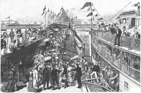
Long Branch, located on the long branch of the Shrewsbury River in Monmouth County, north of Long Beach Island, was also one of the earliest Jersey Shore resorts. According to Gustav Kobbe, Philadelphians were frequenting a local inn as early as 1788. Before the turn of the century, a boardinghouse operated by Herbert and Chandler presented competition for the first summer rentals. [38] By 1840, New Yorkers were coming by steamers (through an inlet, now filled in) that docked along the Shrewsbury River. [39] Steamship transportation made Long Branch (Fig. 12) a competitive destination with Cape May and Saratoga, establishing the future of the quiet Quaker resort that, in 1876, Harper's Monthly Magazine would declare "the great marine suburb of the great metropolis." [40]
|
| Figure 12. Steamboat Landing. Long Branch. Frank Leslie's Illustrated Newspaper. 23 August 1879. |
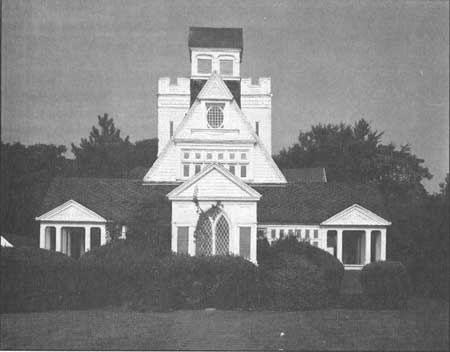
By 1860, Long Branch offered the social schedule and accommodations necessary to attract wealthy celebrities and politicians such as Edwin Booth, Maggie Mitchell, Gen. Winfield Scott, and Mrs. Abraham Lincoln. [41] The city's tradition as a presidential summer resort began in the late 1860s when a group of business and newspaper men bought up beachfront property. After supporting Louis P. Brown in his land-development project, which resulted in the creation of Ocean Avenue, George W. Childs invited President Ulysses S. Grant to experience a Jersey Shore summer. Childs and others pooled their resources to purchase 991 Ocean Avenue for the President and his family, beginning Long Branch's reign as the "summer capital" of the United States. [42] Other presidents followed Grant's example, and Shadow Lawn, the old Elberon Hotel, and an Episcopal church (Fig. 13) near the Takanasses Bridge became known for presidential patronage. The construction of Monmouth Park in 1870 also attracted approval from federal officials. A life-size statue of Grant in front of the track proclaims his fascination with racing.
|
| Figure 13. Church of the Seven Presidents, Long Branch. HABS No. NJ-1083-2. |
The combination of presidential prestige and the competitive spirit of Monmouth Park, which tacitly sanctioned gambling, resulted in a burst of popularity for the city during the 1870s-80s. Stimulated by gambling activity, Long Branch opened clubs such as the Pennsylvania, where the lucky could flaunt their winnings in style. A parade of larger-than-life characters flocked to "the Branch," eager to partake of the action and outdo their contemporaries in lavish display.
Here Lillie Langtry kept her private car for an entire summer on a railroad siding adjoining the home of her current protector; there Diamond Jim Brady drove Lillian Russell in an electric coupe brightly illuminated on the interior rather than with headlights, so that all might see and enjoy; and here Josie Mansfield and Ed Stokes admired Col. Jim Fisk and his regiment in their gold braid as they played at drilling on the Bluff Parade Grounds. [43]
Summer visits by subsequent Presidents Rutherford B. Hayes, Benjamin Harrison, James Garfield (who died at his cottage in Elberon after being shot in Washington in 1881), and Chester A. Arthur contributed to Long Branch's status as the premiere American resort of its time (Fig. 14). Completion of the New York and Long Branch Railroad in 1875 brought train loads of both the urban rich and the middle class to the seashore, where they stayed in elaborate Victorian hotels and boardinghouses.
The hotels were titanic masses of wood and fancy ornamentation. . .two or three stories in height and usually a block long. Their porches were furnished with wicker rockers and chairs, shaded from the sun by huge striped awnings in bright colors. [44]
Hardly a stick of wood remains from hotels such as the West End, which had a wooden footbridge across Ocean Avenue to a two-story beach pavilion.
|
| Figure 14. Shadow Lawn. Summer Capitol, Long Branch, NJ. Postcard, Sarah Allaback, Ca. 1916. |
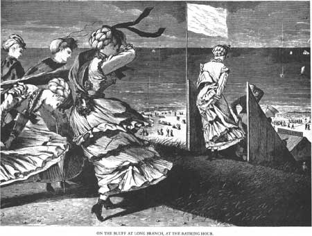
Along with the visitors came speculators with money to invest, attracted by what was later described as "brave, expensive and perilous" advertising, sold with "elaborate pressure methods." [45] These investors have left more tangible evidence of their times. Promoter Lewis B. Brown made huge profits subdividing oceanfront plots in Elberon, a seaside neighborhood in Long Branch's south end. [46] Actor Oliver Byron built fourteen cottages at Long Branch, and financier Jay Gould built four. Elberon's streets were lined with shingled, turreted Queen Anne mansions. Old postcards show street profiles of Ocean Avenue porches, gables, towers, and awnings facing the sea. The house Solomon R. Guggenheim bought in 1899 on Ocean Avenue was "festooned with fretwork from porch steps to gable peaks." [47] Though Guggenheim's house was torn down in the 1940s, examples of cottages by Charles McKim of McKim, Mead and White, such as the Charles Taylor House, remained through the early 1980s. New York architects Peabody and Steams, designers of the now-demolished Elberon Casino, were also active in the city. Artist Winslow Homer came to Long Branch in the late 1800s, engraving beach scenes (Fig. 15) for Harpers and other popular magazines and painting his famous "Long Branch, New Jersey," depicting women with parasols peeking over the bluffs.
|
| Figure 15. On the Bluff at Long Branch. Winslow Homer. Appleton's Journal. 21 August 1869. |
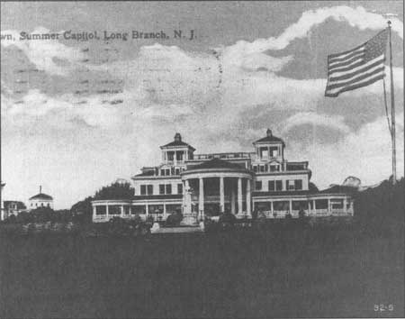
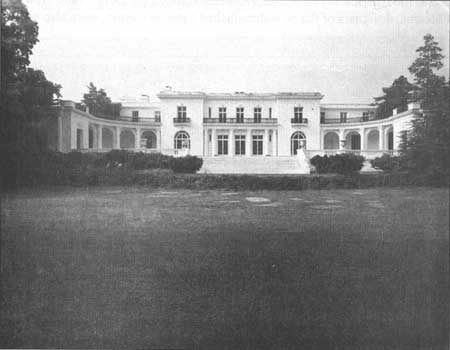
Other evidence of Long Branch at its height can be found inland, mixed with the suburbs and shopping centers that have since surrounded the old business district. In 1905, Murray Guggenheim, son of mining magnate Meyer Guggenheim, hired New York architects Carrere and Hastings to design a palatial residence (Fig. 16). The partners' New York Public Library had gained them a reputation for the kind of civic monumentality Guggenheim must have desired; the Beaux Arts mansion, set amid landscaped grounds at Norwood and Cedar Avenues, resembles a pavilion from the 1893 Chicago World's Fair. The residential design won the architects a gold medal from the New York chapter of the American Institute of Architects. [48] In 1960, the Guggenheim Foundation of New York donated the house to Monmouth College, which now uses it as a library. Also part of Monmouth College is Woodrow Wilson Hall, previously the presidential mansion Shadow Lawn and the set for the movie "Annie." The mansion was built for Hubert Parson, president of Woolworth's, the five-and-dime store chain, and was later used by Woodrow Wilson as a summer residence.
|
| Figure 16. Murray Guggenheim House, Long Branch, HABS No. NJ-1178-1. |
Seabathing
Why did nineteenth-century city dwellers endure the long, uncomfortable trip to the shore, and what sort of activities awaited them when they arrived? Some resort vacationers were interested in hunting and fishing, but more traveled to the shore in search of "the cure." Seabathing was a popular seaside activity performed by young and old to maintain a vigorous constitution (Fig. 17). The early Jersey Shore resorts differed in clientele, atmosphere, and location, but all could boast of limitless opportunities for the popular seaside ritual. A visitor writing from Cape May in 1823 affirmed that "bathing in this surf is the great object of visitants. The bathing consists in walking out to a convenient entrance and either permitting the waves to break over you or diving through them, and various other maneuvers according to skill or inclination." [49] The letter also documented the highly developed etiquette surrounding the bathing process. Each "tavern" supplied a bathhouse for changing into proper attire. Bathers were segregated by sex, not only in the bathhouse but on the beach. Bathing facilities in Cape May maintained a time schedule allowing gentlemen bathing privileges from 6 to 7am and 5:30 to 7pm; ladies could occupy the beach from 7 to 8am, 10 to 11am, 12noon - 1pm and 4:30 to 5:30pm. [50] During the 1830s, the Mansion House utilized a flag system to enforce bathing rules; a white flag signified women's hours, and the red indicated that men might enjoy the beach. [51]
|
| Figure 17. Bathing at Long Branch—"Oh, Ain't it Cold" Every Saturday, August, 1871. Library of Congress. |
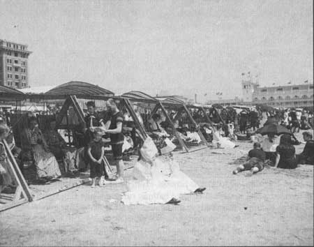
Beginning in 1891, the Atlantic City Beach Patrol was organized to monitor the beach during the bathing hours from 9am to 5pm. The next summer, the city hired twenty lifeguards equipped with ten lifeboats to keep an eye on audacious bathers. Adams and Jacksons' baths, located around Pennsylvania and Virginia avenues near the Steel Pier, were particularly well-patronized facilities that year. "Bathmaster" Alfred Adams charged 50 cents a week for his services, which probably included access to changing rooms. Jacksons', known as a more luxurious bathhouse, accommodated 100 bathers and offered apartments and restrooms with cots. [52] As the proliferation of fancy bathing facilities illustrates, seabathing quickly became more of a social exercise than a health-related activity.
On her visit to Cape May in 1850, Swedish novelist Frederika Bremer observed the unusual equality of human relationships promoted by the bathing experience.
It is, as I have said, a republic among the billows, more equal and more fraternized than any upon dry land; because the sea, the great, mighty sea, treats all alike, roars around all and over all with such a superiority of power, that it is not worth any one's while to set themselves up in opposition to it, or to be as anything beside it; the sea dashes over them all, dashes them all about, enlivens them all, caresses them all, purifies them all, unites them all. [53]
The author went on to describe various seabathers—a young couple, an aged husband and wife, a little boy with his mother, and an old woman—all mingling in the surf despite differences in sex and age. As she qualified the rigid impression of sea bathing earlier in the century, Bremer also alluded to a continually recurring theme—the power of the sea. The literature published by railroads, chambers of commerce, and individuals promoting the Jersey Shore almost always focused on the sea's compelling presence. In the nineteenth century, the ritual of bathing, with its religious and homeopathic associations and defined code of etiquette, was a highly significant cultural activity. Though bathing is no longer laden with such meaning, the sea remains unchanged in its power to draw visitors to the shore for rest and relaxation.
While resort promoters targeted the middle class, those who had been summering for generations at the more exclusive resort communities, such as Long Branch, were less excited about entertaining "excursionists." Reporting for Harper's in 1875, Olive Logan commented on the large number of such travelers crowding the streets and beaches, and contributed a "horrifying" description of their behavior and accoutrements while bathing. She was particularly disturbed by the bathing houses (Fig. 18), "shanties rudely nailed together," built for shelter against the sun and wind. [54] Logan's article emphasized the threat that "camps" of excursionists posed to the security of the upper classes pleasantly established in their weatherbeaten beachfront hotels. Such class issues were central to the changing character of late nineteenth-century "watering places."
Today the New Jersey coast, with its endless boardwalks fringed by shooting galleries and fortune-tellers' booths and hamburger and hot-dog stands and salt-water taffy concessions, is solidly in possession of the millions; the millionaires have been good-naturedly elbowed off the scene. Long Branch, even in its prime, was engaged in the unequal struggle of trying to hold back the masses; it was futilely defying its manifest destiny. It could not be, at one and the same time, the great marine suburb of the great metropolis and the snug harbor of the leisure class. [55]
|
| Figure 18. Atlantic City Bathing Pavilions. On the Beach, Atlantic City, NJ. Library of Congress, ca. 1904. |
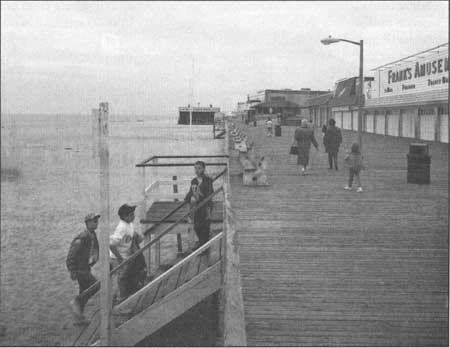
If some regretted the loss of snug harbors, there were certainly more who celebrated the democratization of the shore. The proliferation of amusements along the boardwalk, and finally the boardwalk itself, became the popular symbol of the Jersey resort around the turn of the century.
| <<< Previous | <<< Contents>>> | Next >>> |
new-jersey/resorts-recreation/chap2.htm
Last Updated: 10-Jan-2005