|
Niobrara National Scenic River Nebraska |
|
 NPS photo | |
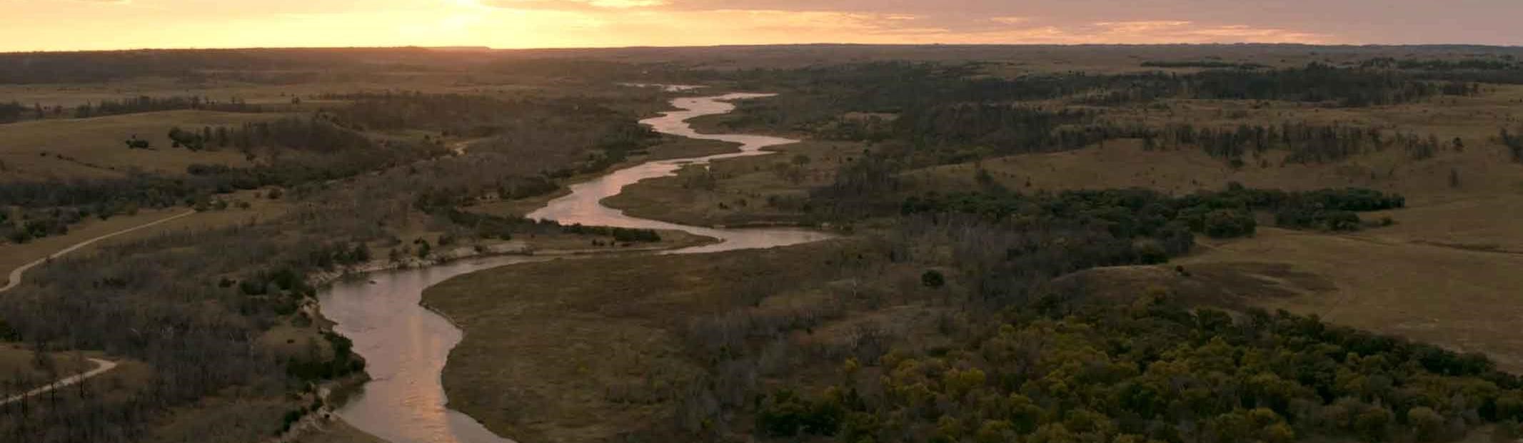
Ni obhatha ke—spreading water river in the Ponca a language—is the heart of this land. The ancient, free-flowing waterway has carved through Earth's layers and flowed through time. The Niobrara has sustained human life for over 12,000 years and revealed fossils up to 16 million years old.
Today six ecosystems converge along its banks, creating a diversity of life. Here you can see bison grazing, listen for the songs of over 200 birds, paddle a canoe, dip your feet into the cool water, and connect with family, friends, and nature.
Flowing Through Time
The Niobrara River begins to the west in the high plains of eastern Wyoming. It flows 535 miles east and empties into the Missouri River in northeastern Nebraska.
Over millions of years, volcanic eruptions and gradual erosion of the Rocky Mountains deposited layers of silt and sand. The Niobrara River has cut 300 feet into these prehistoric layers, creating spectacular bluffs and waterfalls that you may see during your visit.
Ash Hollow Formation The top and most recent layer is a grayish sandstone. It is best seen on hills north of the river and in roadcuts along highways like NE 12.
Valentine Formation This layer of pale, soft sandstone holds much of the area's water from the Ogallala Aquifer, and world-class fossil mammals.
Rosebud Formation Hard, pinkish siltstone forms most of the bluffs along the river.
Pierre Shale This oldest rock layer is exposed in areas of the eastern half of the river, creating striking, nearly black bluffs.
Over 200 waterfalls occur along the western part of the river. These tributaries flow over the Rosebud Formation. Some waterfalls drop into the Niobrara, while others are found in spring-fed streams.
The Ogallala Aquifer, a fragile, vast underground reservoir, is partially recharged by rainwater and snowmelt. Through springs, seeps, and waterfalls it provides most of the water to the Niobrara.
Biological Crossroad
Unique, diverse, and biologically sensitive are words that describe the landscapes of Niobrara National Scenic River. Six major ecosystems converge here. East meets west, north meets south, and the Pleistocene environment of the Ice Age meets modern-day climate uncertainties.
Mixed grass, tallgrass, and Sandhills prairies; northern boreal, western coniferous, and eastern deciduous woodlands coexist here in close proximity—and nowhere else in the country. Paper birch trees and quaking and big-tooth aspen survive in north-facing areas where they are protected from summer heat and winds. Some flora and fauna have adapted by developing hybrid species, some found only in the Niobrara valley.
The 100th Meridian, an imaginary "dividing line" between the eastern and western United States, runs through the Niobrara National Scenic River. The river itself divides the Sandhills from the Badlands. Ecosystems from all directions meet here, and sometimes hybrids form.
Floating the Niobrara
Most people float the river from mid-June through Labor Day. Summer weekends can be very busy; weekdays are quieter and rarely crowded. Only experienced, properly equipped boaters should attempt a winter trip.
The 22-mile stretch from Fort Niobrara National Wildlife Refuge, near Valentine, to Rocky Ford Rapid is the most frequently traveled. You can plan a trip on your own, or go with a local outfitter. Trips range from one hour to several days.
River Safety
All individuals must have a US Coast Guard approved personal flotation device (PFD). Children under 12 must wear a PFD while on the river. • If you capsize, keep calm. Stay at the upstream end of your vessel. Lie on your back with your feet pointed downstream. Let your PFD keep you afloat. Swim to shore after reaching calmer water. • In summer, signs identify major rapids between Valentine and Norden Bridge. You are strongly cautioned to portage around these dangerous obstacles. • Watch for overhanging limbs and submerged logs that can overturn your vessel. • Wear shoes to protect your feet. • Be aware of land hazards like poison ivy, stinging nettles, ticks, slippery banks, crumbling cliffs, and rattlesnakes. • Do not dive or jump into the river. The Niobrara can be shallow, with many rocks. • Tying too many tubes together is hazardous—you can get trapped under the tubes. • Cellphones may not work in the river valley. Rocky Ford has a public phone from May through August.
Emergencies call 911
River Etiquette
Share the river respectfully with other users and wildlife. • Keep noise levels low. • Tie your gear to your vessel. • Find trash and recycling dumpsters at most landings. • Do not trespass on the private land that borders the river. • Federal and state alcohol laws are enforced.
Planning Your Visit
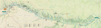 (click for larger map) |
Most people come to the Niobrara to float the river by canoe, tube, or kayak. The western portion, from Fort Niobrara to Rocky Ford Rapid, is the most popular section. Public landings are available. Private outfitters on this stretch offer rentals for boating, tubing, fishing, hunting, camping, and cabins. The eastern portion, from Norden Bridge downstream, is seldom floated. It is often shallow, with a braided channel; it is not served by outfitters. Before setting out, check our website for river conditions and a paddler's guide: www.nps.gov/niob.
On the River
Borman Bridge to Cornell Dam
The Refuge portion is closed to visitors to ensure visitor safety and protect
wildlife habitat.
Cornell Dam to Berry Bridge
The river runs through a federally designated wilderness. Its banks are
undeveloped, with prairie, steep cliffs, and pine-covered hills. This section
includes one Class I rapid (see International Scale of Difficulty
below). A fee is charged at the Fort Niobrara launch.
Berry Bridge to Brewer Bridge
The river flows through forested hills of pine and deciduous trees, with a
number of easy riffles and one Class I rapid.
Brewer Bridge to Rocky Ford
Here rapids (Class I or II) are easily negotiated by most novices. These rapids
can change in character with differing water levels. Warning: At Rocky
Ford Rapid (Class III), canoeists and tubers need to portage the falls;
whitewater kayakers should scout the rapid before attempting a run.
Rocky Ford to Norden Bridge
This section receives light use. Rapids (Class I to Class IV) occur below Rocky
Ford Rapid. Warning: Norden Chute, above Norden Bridge, is a dangerous
obstacle. It must be portaged.
Norden Bridge to Highway 137
This section of the river can be navigated, but seasonally shallow water, Eagle
Rapid, and sandbars may make the trip difficult.
International Scale of Difficulty
Class I: Fast moving water, riffles, and small waves. Few obstructions.
Class II: Basic rapids with wide, clear channels. Obvious without
scouting. Some maneuvering required.
Class III: Rapids with moderate, irregular waves often capable of swamping
open-bow canoes. Fast currents and narrow passages require complex maneuvering.
May require scouting from shore.
Class IV: Difficult rapids, irregular waves or dangerous obstacles,
rocks, and falls. Powerful and precise maneuvering required in very turbulent
water. Scouting required. Rescue may be difficult. Unsuitable for an open
canoe.
Regulations
Private lands border the river in most areas. Respect private property rights—do not trespass. • Do not harm plants, collect fossils, or disturb animals. • Do not climb on crumbling cliffs or delicate waterfalls. • Using alcohol or drugs while on the river can cause injury and death. Alcohol is prohibited within Fort Niobrara National Wildlife Refuge. The consumption of alcohol is prohibited at Brewer Bridge. • For fishing and hunting, licenses are required, as is landowner permission to hunt on private land. State fishing and hunting regulations apply within the river boundary. Hunting is by permit only at Fort Niobrara National Wildlife Refuge. • For details about accessibility and firearms and other regulations, see the park website. • Airboats and personal watercraft are prohibited.
Emergencies call 911
Fees Fort Niobrara National Wildlife Refuge charges a launch fee. Smith Falls State Park charges entrance and campground fees. Private outfitters have landing, campground, transportation, and rental fees.
Services
Lodging, Food, and Services
These are found in nearby towns.
Valentine Chamber of Commerce
239 South Main
Valentine, NE 69201
www.visitvalentine.org
Ainsworth Chamber of Commerce
335 North Main
Ainsworth, NE 69210
www.ainsworthchamber.com
Camping and Boat Launches
Public and private campgrounds and launch sites are found along the river
between Fort Niobrara National Wildlife Refuge and Meadville. A public
campground is available at Smith Falls State Park. Make prior arrangements for
camping and river access.
More Information
Niobrara National Scenic River
214 West Hwy. 20
Valentine, NE 69201
www.nps.gov/niob
Fort Niobrara National Wildlife Refuge
39983 Refuge Rd.
Valentine, NE 69201
www.fws.gov/refuge/fort_niobrara
Smith Falls State Park
90159 Smith Falls Rd.
Valentine, NE 69201-9103
www.outdoornebraska.gov/smithfalls
Niobrara Council
365 North Main, Suite 1
PO Box 206
Valentine, NE 69201
www.niobraracouncil.org
Source: NPS Brochure (2019)
|
Establishment Niobrara National Scenic River — May 24, 1991 |
For More Information Please Visit The  OFFICIAL NPS WEBSITE |
Documents
Computations of Total Sediment Discharge Niobrara River Near Cody, Nebraska U.S. Geological Survey Water-Supply Paper 1357 (B.R. Colby and C.H. Hembree, 1955)
Final General Management Plan / Environmental Impact Statement, Missouri/Niobrara/Verdigre Creek National Recreational Rivers, Nebraska-South Dakota 39-Mile (June 1997)
Final General Management Plan / Environmental Impact Statement, Niobrara National Scenic River, Nebraska (September 2006)
Flows and Recreational Floating on the Niobrara National Scenic River, Nebraska (Doug Whittaker and Bo Shelby, April 2008)
Foundation Document, Niobrara National Scenic River, Nebraska (October 2016)
Foundation Document Overview, Niobrara National Scenic River, Nebraska (undated)
General Management Plan and Environmental Impact Statement, Niobrara National Scenic River Draft (2003)
Geologic Framework of the Niobrara River Drainage Basin and Adjacent Areas in South Dakota Generally East of the 100th Meridian West Longitude and West of the Missouri River Nebraska Geological Survey Report of Investigations No. 9 (R.F. Diffendal, Jr., and M.R. Voorhies, May 1994)
Geology and Ground-Water Resources of the Upper Niobrara River Basin, Nebraska and Wyoming U.S. Geological Survey Water-Supply Paper 1368 (Edward Bradley, 1956) / Chemical Quality of the Ground Water (F.H. Rainwater)
Geomorphic Segmentation, Hydraulic Geometry, and Hydraulic Microhabitats of the Niobrara River, Nebraska—Methods and Initial Results U.S. Geological Survey Scientific Investigations Report 2009-5008 (Jason S. Alexander, Ronald B. Zelt and Nathaniel J. Schaepe, 2009)
Ground-Water Resources of the Lower Niobrara River and Ponca Creek Basins, Nebraska and South Dakota U.S. Geological Survey Water-Supply Paper 1460-G (Thomas G. Newport, 1959) / Chemical Quality of the Ground Water (Robert A. Krieger)
Historical Overview and Inventory of the Niobrara/Missouri National Scenic Riverways, Nebraska/South Dakota (Rachel Franklin, Michael Grant and Martha Hunt, 1994)
Hydrogeomorphic Segments and Hydraulic Microhabitats of the Niobrara River, Nebraska—With Special Emphasis on the Niobrara National Scenic River U.S. Geological Survey Scientific Investigations Report 2010-5141 (Jason S. Alexander, Ronald B. Zelt and Nathan J. Schaepe, 2010)
Investigations of Fluvial Sediments of the Niobrara River Near Valentine, Nebraska U.S. Geological Survey Circular 205 (B.R. Colby, D.Q. Matejka and D.W. Hubbell, 1963)
Junior Ranger Activity Booklet, Niobrara National Scenic River (2013; for reference purposes only)
Niobrara National Scenic River Condition Assessment NPS Natural Resource Report NPS/NRPC/NRR-2010/172 (Sunil Narumalani, Gary D. Wilson, Christine K. Lockert and Paul B. T. Merani, January 2010
Plant Community Composition and Structure Monitoring Protocol for the Northern Great Plains I&M Network Version 1.01 NPS Natural Resource Report NPS/NGPN/NRR-2012/489 (Amy J. Symstad, Robert A. Gitzen, Cody L. Wienk, Michael R. Bynum, Daniel J. Swanson, Andy D. Thorstenson and Kara J. Paintner-Green, February 2012)
Preliminary Report on the Geology and Water Resources of Nebraska West of the One Hundred and Third Meridian U.S. Geological Survey Professional Paper 17 (Nelson Horatio Darton, 1903)
White-Nose Syndrome Surveillance Across Northern Great Plains National Park Units: 2018 Interim Report (Ian Abernethy, August 2018)
niob/index.htm
Last Updated: 01-Jan-2025