|
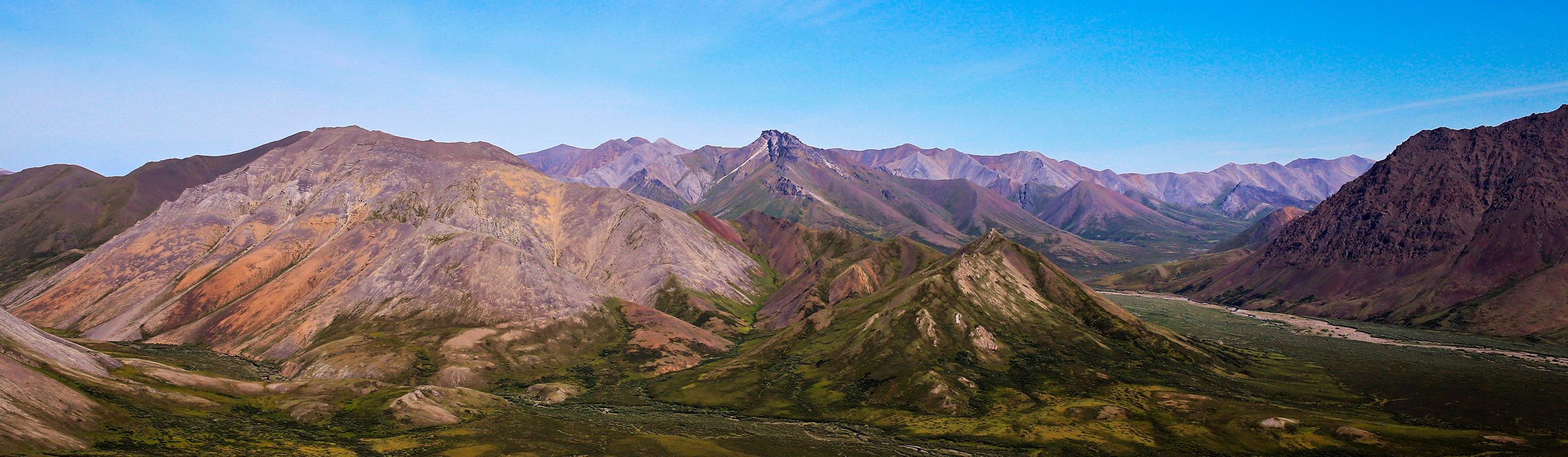
Noatak National Preserve Alaska |
|
 NPS photo | |
Expansive Arctic and Subarctic Wildlands
Known simply as the Western Arctic National Parklands, four units of the National Park System stretch eastward from the Chukchi Sea for some 290 miles to the upper Noatak River. Cape Krusenstern National Monument, Kobuk Valley National Park, Noatak National Preserve, and Bering Land Bridge National Preserve together protect some 11.8 million acres of subarctic and arctic wildlands. They also offer, on the Noatak and Kobuk rivers, some of North America's finest waters for wilderness expeditions. These parklands contain the western terminus of the Brooks Range, which is the northernmost extension of the Rocky Mountain Range. They trace the treeline or northern limit of tree growth as the boreal forest gives way to the tundra that stretches northward to Point Barrow on the Beaufort Sea. The Western Arctic National Parklands protect the archeologically significant beach ridges of Cape Krusenstern, the Great Kobuk Sand Dunes, and most of the expansive watershed of the Noatak River and commemorate the people of the Americas who crossed the Bering Land Bridge in prehistoric times. With Gates of the Arctic National Park they extend 350 miles inland and encompass 19.5 million acres. Linked to this expansive topography is the wide-ranging, nomadic Western Arctic herd of barren ground caribou. In 2000 the herd numbered more than 450,000 animals. The tundra offers a thin veneer of life across which caribou must move to forage for adequate food. In summer the land is covered with a profusion of low-growing plants, including dwarfed ground willows, saxifrage, lupines, reindeer moss, and lichens. The caribou has a strong presence in native stories of this region. Native peoples here were often semi-nomadic, following the caribou migrations. Even the coastal peoples of Cape Krusenstern ranged inland to hunt caribou and to hunt and trap other land mammals when the sea mammals so important to their lives were scarce. Throughout these parklands, local residents still pursue caribou hunting, fishing, trapping, and other subsistence activities. Many residents rely significantly on locally harvested animals, fish, and plants for satisfying basic food needs. The Inupiat people traditionally valued the land so that, through wise use over thousands of years, its resources and productivity were carefully preserved for the benefit of future generations. The National Park Service has a compatible mission—of stewardship of this vast reach of northwest Alaska for the use and enjoyment of this and coming generations. From the visitor centers it is difficult to imagine the extent of the Noatak River—whose name means "passage to the interior"—or the expanse of the annual caribou migrations throughout the immense area that these parks encompass. For information about the Bering Land Bridge National Preserve, please see its individual brochure.
Noatak
As one of North America's largest mountain-ringed river basins with an intact, unaltered ecosystem, the Noatak River environs feature some of the Arctic's finest arrays of plants and animals. The river offers equally superlative wilderness float-trip opportunities—from deep in the Brooks Range to tidewater of the Chukchi Sea. Noatak National Preserve lies almost completely enclosed by the Baird and De Long mountains of the Brooks Range. In this transition zone, the northern coniferous forest thins out and gradually gives way to the tundra that stretches northward to the Beaufort Sea. The Noatak basin is internationally recognized as a Biosphere Reserve. Under this United Nations scientific program the area's ecological and genetic components are monitored to establish baseline data for measuring changes in other ecosystems worldwide. Information can also be gathered here on sustainable uses of natural resources by humans, as exemplified by the Inupiat and other native peoples who have lived off the land of northwest Alaska for many thousands of years. The Noatak River is classified as a national wild and scenic river from its headwaters to the Kelly River. Activities: Gentle and slow moving except in the Brooks Range headwaters, the Noatak offers fine canoeing. kayaking, and rafting. Aircraft landing on gravel bars or rivers or lakes provide access for fishing, hiking, backpacking, hunting, and other recreational pursuits.
Caribou, Nomads of the North
Caribou migrations are one of the wonders of the subarctic and arctic realms. Traditionally, caribou have been among this region's chief food sources for humans, predators, and scavengers. The populations of some other animals species may even fluctuate with that of the caribou. Native peoples have depended on caribou for food, clothing, shelter, and tools, using the entire animal. For food: meat, greens from the stomach, and fat. For clothing: hides for coats called parkies, trousers, boots called mukluks, and mittens, plus sinew to sew them. For shelter: hides for tents. For tools: antler and bone for needles, sleigh brakes, fish spears, knife handles, arrowheads, hide scrappers, and snow shovels.
Life on the Tundra
Truly migratory, caribou move about the tundra in constant search of
plant foods to support their body weight: 150 to 300 pounds for bulls.
Tundra is a mat of mostly prostrate vegetation that can grow where short
summers and other conditions preclude tree growth. Tundra is often
underlain by permanently frozen ground called permafrost. The ground
surfaces of wet tundra and moist tundra thaw in summer and stay
waterlogged because permafrost prevents ready drainage. Alpine tundra
often grows on rocky ground that drains very rapidly: the ground thaws
in summer, but plants must resist drying out. Caribou feed on grasses
and grass-like sedges; small shrubs and their berries; and twigs and
bark. In winter, when these are not as available, they eat significant
amounts of a lichen called reindeer moss. Caribou can dig through snow
to find food unless the crust is too hard, in which case they may suffer
malnutrition and even starve. Besides the predators, chief antagonists
of caribou in summer are the caribou warble fly, caribou nostril fly,
black fly, and mosquito. Caribou may even stop eating while trying to
avoid the Arctic's summer hordes of biting insects. Mosquitoes, however,
are an important food source—converting the productivity of plants
into protein—that sustain abundant bird and fish life of the
north.
Range and Migrations
Known as "nomads of the north," caribou have lived in most of Alaska
except its southeastern panhandle. In their yearly wanderings, caribou
of Western Arctic herd range over 140,000 square miles, including the
entire four parks that make up the Western Arctic National Parklands.
The herd—North America's largest—is more than 450,000 at this
writing. Spring migration begins in March: the herd's main body crosses
the Kobuk and Noatak rivers moving northward to calving grounds on the
Arctic Coastal Plain. Many of the caribou begin to cross the Noatak
southward in late August and the Kobuk in September. The winter range
lies south of Kobuk Valley National Park and the Selawik National
Wildlife Refuge.
Caribou have adapted to this harsh and demanding environment in many ways. Hollow caribou hair traps substantial air for excellent insulation against the cold. Its buoyancy is evident when the animals cross rivers; they float very high.
The caribou's dew claws and spreading cleft hooves help support its weight on soft ground and snow. In winter the hoof's sharp edges help the caribou on frozen terrain.
Adult bulls can accumulate fat deposits—mostly on the back and rump—that weigh 60 pounds or more in early fall. They lose the fat during the rutting, or mating, season.
Wolves and Other Predators
The principal predators of the caribou are the wolf and bear.
Wolverines, foxes, and eagles prey on calves. Any of the above, as well
as weasels, lemmings, some hawks, ravens, gray jays, and gulls, will
scavenge caribou carcasses. Some wolves, especially on North Slope
calving areas. will follow the caribou herd. However, many wolves reside
in specific locations. Wolves hunt caribou by stealth and ambush, by
relay running, or by culling victims of falls from running in a tightly
massed herd. Healthy adult caribou can normally outrun single wolves and
have the advantage on ice. Wolves have the advantage on soft tundra and
in some snow conditions.
Western Arctic National Parklands
Access and Information
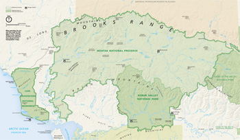 (click for larger map) |
Cape Krusenstern National Monument, Kobuk Valley National Park, Noatak National Preserve, and Bering Land Bridge National Preserve together are known as the Western Arctic National Parklands. The parks' information center and the headquarters offices in Kotzebue and Nome are open Monday through Friday. At these locations you can buy topographic maps, aeronautical charts, and books on the region, and get information on hunting and fishing regulations, location of private lands within the park units, minimum impact camping, bear safety, and other important topics. Kotzebue and Nome can be reached only by air. These airports are served both by scheduled airlines and by many Alaska package tour companies.
Transportation. People generally reach the Western Arctic National Parklands by scheduled airlines from Fairbanks or Anchorage. Scheduled flights are available from Kotzebue and Nome to nearby villages. Check at the visitor centers for a list of the villages. Air taxi or charter flights are available from Kotzebue, Nome, Ambler, Bettles, and Fairbanks. Write to the superintendent for a list of authorized air taxi services for Cape Krusenstern National Monument, Kobuk Valley National Park, Noatak National Preserve, and Bering Land Bridge National Preserve.
Activities
There are no National Park Service developments, services, campgrounds, or trails in these park areas. Summer access to and through them includes motorized and non-motorized watercraft, aircraft, and by foot. Light aircraft land on gravel bars and tundra airstrips or on rivers, lakes, and lagoons. Floating the major rivers can be the experience of a lifetime.
At Cape Krusenstern, kayaking along the coast and through lagoons is possible. Camping, hiking, backpacking, wildlife observation and photography are popular activities.
At Kobuk Valley, motorboats, kayaks, canoes, and rafts are used on the river. The Great Kobuk Sand Dunes, up to 150 feet high, are an easy hike from the Kobuk River.
At Noatak, fine canoeing, kayaking, and rafting opportunities abound on the Noatak River. Aircraft also provide access for fishing and backpacking.
At Bering Land Bridge, camping and hiking. Backpacking, birding, and coastal boating are among many possible activities.
Regulations
Private property. Private lands are located within all four areas, generally along rivers and beaches. Respect property and privacy.
Subsistence use. Local residents engaged in a subsistence way of life are legally permitted to continue subsistence. Please do not interfere with subsistence camps, fishnets, or other equipment.
Fishing. Fishing can be good when rivers are clear and fish are running. Species include grayling, arctic char, sheefish, salmon, pike, and whitefish. An Alaska fishing license is required for all persons 16 years of age or older. Alaska fish ing seasons and regulations apply.
Hunting. Sport hunting is permitted in Noatak National Preserve and Bering Land Bridge National Preserve with an Alaska hunting license. Alaska seasons and regulations apply. Kobuk Valley National Park and Cape Krusenstern National Monument are closed to sport hunting. Subsistence hunting by local residents living in identified resident zones is permitted in all four areas. State and federal subsistence hunting regulations apply.
Camping. The four park areas have no designated campgrounds. Tundra and river bars are often used for camping. Use river bars with caution: Rapid changes in river levels can occur without warning. Camp only where escape routes are available to safe higher ground. Keep gear above river level and secure boats and other floatable items.
Precautions
This is a vast area subject to harsh weather, high winds, rain, and snow. Guard against hypothermia, an all-season killer. Animals are wild and must be respected. Before traveling in the backcountry, review the brochures about handling wildlife encounters. These are available at the visitor centers or by mail. Mosquitoes and biting flies are prevalent; headnets and/or repellent are recommended. Drinking water should be boiled for one minute before use. Giardia lamblia can be a problem. You must possess good backcountry skills for wilderness survival. Know—and test—your gear before you arrive.
For your safety, leave your itinerary with someone and notify that person when you complete your trip. Winter travel can be recommended only to those experienced in arctic camping and survival techniques.
Bear Warning
Grizzly and black bears are common to the parks. They are unpredictable and dangerous. Never surprise or approach them closely; stay cautious and alert at all times. Make noise—loud talking, ringing a bell, shaking stones in a can, etc. If you meet a bear, yield the right-of-way by moving slowly away, not by running.
Clean camps are essential to reducing bear problems. The odors of various foods, lotions, toothpaste, shaving cream, etc., attract bears. Keep sleeping and cooking areas separate. Store food and scented articles in airtight containers. Leave scented foods such as bacon and smoked fish at home. Burn and carry out all garbage. It is legal to carry a firearm for bear protection.
Source: NPS Brochure (2002)
|
Establishment
Biosphere Reserve — 1976 |
For More Information Please Visit The  OFFICIAL NPS WEBSITE |
Documents
Alaskothyris New Genus (Family Stringocephilidae, Subfamily Rensselandiinae) from the Givetian (Upper Devonian) of the Northwestern Brooks Range, Northern Alaska (Robert B. Blodgett, Valeryi V. Baranov and Vincent L. Santucci, from New Mexico Museum of Natural History and Science Bulletin No. 67, 2015, ©New Mexico Museum of Natural History and Science, all rights reserved)
Climate Change Scenario Planning for Interior Arctic Alaska Parks: Noatak — Gates of the Arctic — Kobuk Valley NPS Natural Resource Report NPS/AKSO/NRR-2014/833 (Robert Winfree, Bud Rice, John Morris, Nancy Swanton, Don Callaway, Jeff Mow, Nancy Fresco and Lena Krutikov, July 2014)
Community gradients of macrolichen in the Noatak National Preserve, Alaska, USA (Emily A. Holt, Bruce McCune and Peter Neitlich, Date Unknown)
Demography of Grizzly Bears in Relation to Hunting and Mining Development in Northwestern Alaska (HTML edition) Scientific Monograph NPS/NRARO/NRSM-93/23 (Warren B. Ballard, Lee Anne Ayres, Daniel J. Reed, Steven G. Fancy, Kathryn E. Roney, 1993)
Foundation Statement, Noatak National Preserve, Alaska (July 2009)
Landbird Monitoring in the Arctic Network, Gates of the Arctic National Park and Preserve and Noatak National Preserve (2010 Report) NPS Natural Resource Data Series NPS/ARCN/NRDS-2012/315 (Kristin DeGroot and Jennifer McMillan, April 2012)
Macrolichen Diversity in Noatak National Preserve, Alaska (Bruce McCune, Emily Holt, Peter Neitlich, Teuvo Ahti and Roger Rosentreter, May 28, 2007)
Park Newspaper (Arctic Views): 2000 Western Arctic National Parklands (©Alaska Natural History Association)
Stability of Ice-Wedges in Kobuk Valley National Park and the Noatak National Preserve, 1951-2009 NPS Natural Resource Report NPS/ARCN/NRR-2016/1248 (David K. Swanson, July 2016)
State of the Park Report, Noatak National Preserve, Alaska State of the Park Series No. 46 (2017)
Surficial Geologic Map of Parts of the Misheguk Mountain and Baird Mountains Quadrangles, Noatak National Preserve, Alaska USGS Open-File Report 2003-367 (Thomas D. Hamilton, 2003)
Traditional Affiliation Scoping Study: Kobuk Valley National Park (Douglas Deur, Eileen Devinney, Katie Wynia and Hannah Atkinson, 2017)
Traditional Use Study: A Phase 1 Review of Existing Literatures Relating to Traditional Noatak Caribou Hunting, Kobuk Valley National Park (Douglas Deur, Jamie Hebert and Hannah Atkinson, 2021)
Tree Investigations in the Noatak National Preserve, Alaska, 2011-2022: Old-growth and New Forests NPS Natural Resource Report NPS/ARCN/NRR-2023/2611 (David D. Swanson, December 2023)
Vegetation and Snow Phenology Monitoring in the Arctic Network through 2020: Results from Satellites and Land-based Cameras NPS Natural Resource Report NPS/ARCN/NRR-2021/2337 (David K. Swanson, December 2021)
Whitefish: Traditional Ecological Knowledge and Subsistence Fishing in the Kotzebue Sound Region, Alaska Alaska Department of Fish and Game Technical Paper No. 290 (Susan Georgette and Attamuk Shiedt, January 2005)
noat/index.htm
Last Updated: 10-Mar-2025