|
North Cascades National Park Service Complex Climbing Notes 2004 |
National Park Service U.S. Department of the Interior |

|
| October 2003 Flood Affects Access |
The October 2003 flooding of the Skagit River and Stehekin River watersheds has damaged and in some cases destroyed traditional access points to North Cascades National Park climbing areas. Record flood waters from rainfall in excess of 20 inches fell in the North Cascades, washing away roads, bridges, and culverts.
The Cascade River road was hit hard when Boston, Midas and Morning Star Creek floodwaters eroded culverts and breached the roadway. Access to popular climbing areas, such as Boston Basin and Cascade Pass, will be by foot travel only until road repairs have been completed sometime this summer.
The Stehekin River sent 25,900 cubic feet of water per second toward Lake Chelan in the second flood within six days. The NPS shuttle will be unable to operate along the Stehekin Valley road due to flood damage. Climbs of Mount Goode by way of Stehekin will have a significantly longer approach.
Wilderness trail bridges, foot logs and bridge abutments were hit hard as well. The bridge over Thunder Creek at McAllister camp once provided climbers completing the Inspiration Traverse with a reliable way to cross Thunder Creek. The floods wiped out the bridge, which will likely be replaced by a footlog sometime this summer.
Late 2003 preliminary repair costs for roads and trails have been estimated at several million dollars. Availability of funding to complete repairs and length of time needed is not yet determined.
Repairs to wilderness structures (bridges and constructed trail features) will adhere to the Park's Wilderness Management Plan. This means that only areas that lie in previously established maintenance zones will receive repairs. In some cases, environmental assessments (EA's) must be completed if significant alterations are considered, and this could extend the time frame for repairs into 2005 or beyond. Storm effects in cross-country zones will not be altered, even if known routes (i.e. "climbing trails") were affected. The spring 2002 avalanche across the Boston Basin route was a similar situation.
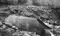
Washout at Boston Creek, Cascade River Road
What does all this mean to the wilderness traveler?
Prior to planning your trip, check with the Wilderness Information Center (360-873-4590 ext. 39) to get the latest information on road, trail, and bridge repairs or limits to access.
You can also check the park's website at www.nps.gov/noca for updates on conditions. Road access may be limited, so allow time for additional foot travel on some routes. The absence of wilderness bridges and foot logs that previously provided access will challenge wilderness travelers to explore safe, low-impact alternatives for early-season high-water crossings.
Climbers should remember that weather conditions and time of year will affect accessibility and degree of challenge as well.
| 2003 Search and Rescue Incidents |
North Cascades National Park personnel responded to 16 incidents in 2003, two of which were assistance in adjacent USFS areas. The total unprogrammed emergency cost to the National Park Service was $21,118.00, of which $8277.00 was for helicopter evacuation. Also noted, 50 percent of the total accidents involved the evacuation of hiking-related injuries. Four of the 2003 incidents are summarized below:
December 2, 2002
Overdue, weather, disoriented
A climbing party was reported overdue on the North Face of Mount Shuksan. A helicopter was dispatched with park rangers to locate the overdue party. The climbers were located on the descent route below Fisher Chimney. Climbers reported being disoriented in the Winnie's Slide area of the route and had taken an extra day to locate the Fisher Chimney descent route. The overdue climbers were contacted and were willing and able to complete their trip without additional assistance.
July 6, 2003
Unroped fall, no helmet, inadequate gear
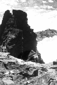
Three climbers were completing a climb of Mt. Logan via the Banded Glacier when two of the party decided to scramble (unroped) a nearby adjacent peak. On the descent they were in different gullies, when one of the climbers fell, cartwheeling with a large rock, fracturing both fibulas and sustaining a head injury. One member hiked out through the night to get help. The injured party was assisted through the night by a highly prepared party also in the area. In the early morning, NPS rangers and an ER physician (volunteer Mountain Rescue member) were flown to the scene. The seriously injured climber was short-hauled to a staging area where an air ambulance waited. After transfer to the second helicopter, he was flown to Harborview Medical Center.
August 17, 2003
Lower leg injury, unable to walk out
Three climbers were completing the Ptarmigan Traverse when one climber sustained a lower leg injury and was unable to continue the trip. The party sent one member out to contact the NPS and request assistance. Park rangers flew to Kool Aid Lake and evacuated the injured climber to Marblemount.
October 5, 2003
Fall, roped, protection failure
Two climbers were ascending the southwest face of Mt. Shuksan. The climbers ascended the first 250 feet without setting protection due to the cracks being filled with soil and vegetation. The leader, wearing a heavy pack, set up the initial belay station and climbed, setting only one piece of protection, until he hit a roof and began to traverse. He set only one piece of protection along the traverse as well, due to limited options. While traversing he fell, pulling the protection, striking the rock face several times and sustaining a serious shoulder and lower leg injury. His climbing partner was able to lower the injured climber to the lower Curtis glacier and hike out for assistance. NPS rangers evacuated the injured party via helicopter. The climber later reported that the combination of wearing a heavy pack and having inadequate protection contributed to his accident.
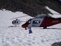
Helicopters staging for Mt. Logan rescue
Impact Monitoring Update ...
Footsteps Matter
Where are your footsteps landing, and in what location do you choose to place your tent? There is a lot at stake in how you answer these important questions. A single climber's footsteps may be insignificant, but consider multiplying one set of footsteps by 1248 visitor nights during one climbing season.
Boston Basin is one of the park's highest-use climbing destinations. Historical records show climbing use as early as the 1930s, when mountaineers explored and summited many of the surrounding peaks. In 2003, 362 overnight backcountry permits were issued for the Boston Basin cross-country zone. Over the years, all of these parties have pitched their tent or bivy sack at some location in the basin.
Climbers in Boston Basin have long noticed the awe-inspiring peaks, but have you also noticed areas denuded of alpine vegetation? High overnight use, combined with an increasing number of day climbers, has contributed to a variety of impacts in this very busy area. Recent surveys documented 43 different impacted camp sites in the basin. Have you ever wondered how these wilderness impacts are addressed?
In October 2003, park staff met on location in Boston Basin to discuss the landscape's dynamic environment and to consider the trade-off between implementing stricter permit quotas versus continued emphasis on low impact techniques and education. North Cascades National Park asks all wilderness visitors to learn and practice the Leave No Trace (LNT) skills of traveling and camping on durable surfaces. Following these and other LNT guidelines will reduce additional alpine vegetation impacts and control existing impacts.
So, remember, footsteps matter. Where are your footsteps landing?
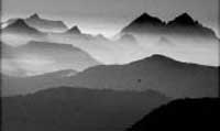
Cascade vista from Copper Ridge
Are You a Minimum Impact Mountaineer?
Bivy...picket...Golite umbrella - check monster cookies - check blue bags blue bags!?! Whoa, hold it right there!
Yes, it's true — while planning for your awe-inspiring, challenging summit assault, it is critical to think not only of your personal and culinary enjoyment, but also of how your presence might affect the wilderness. It's part of a climber's code of ethics.
Take this quiz to see how well you know your mountaineering Leave No Trace:
Q: Throwing my poop into a crevasse is an acceptable disposal method on a glacier.
A: False — Most Pacific Northwest glaciers are too small, and glacial runoff carries pathogens into the water stream (sometimes as quickly as one hour later!).
Q: Even if I am "just bivying on the ridge," I still need a backcountry permit.
A: True — Yes, even if your bivy site is really, really small and rocky anytime you spend the night in the park complex, you need to get a free backcountry permit. Permits help reduce crowding, distribute use evenly, and reduce route impacts.
Q: When I am off trail in a cross-country area, I can camp wherever I want.
A: False (or True with caveats) — Choose a site well away from water, on rock (smooth slabs are clean and durable) or snow. Never pitch your tent or take a break on any heather or woody plants — even if they're already bedraggled. The damage from just a few footsteps and tents can be irreparable.
Ultimately, Leave No Trace is about considering your potential impact, and trying to make the best choices you can each time. Awareness is half the battle — so keep yourself informed about impacts and new techniques. The choices you make today will shape your wilderness of tomorrow.
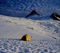
Camp on snow or rock, not vegetation
South Face of Forbidden Peak, fixed rope removed
In August of 2003, an NPS Ranger removed two fixed climbing ropes — estimated to be at least 25 years old- from the south face of Forbidden Peak.
The two 150-foot climbing ropes, now faded white from their years in the sun, were visible from camping areas in Boston Basin. The ropes were also visible from the East Ridge of Forbidden. Besides the impact that the ropes had on the aesthetics of the wilderness, the lines represented a safety concern to the park. On at least one occasion, climbers camping in Boston Basin mistook the ropes as a sign of a recent accident and raised a false alarm.
To remove the ropes, which were attached to an anchor about sixty feet below the East Ridge route, a climbing ranger rappelled 250 feet down the south face to the base of the lines, which were wrapped around a boulder, perched on a ledge 1500 feet above the glacier. The ropes were freed from the boulder and hiked out. The ranger noted several other rappel and fixed anchor stations in the vicinity.
Ranger rappelling to remove fixed rope
No one is quite sure of the history of the fixed ropes, but they are most likely the remnants of a climbing accident in the late 1970s. Although climbing accidents may result in the abandonment of gear, most ordinary trips into the mountains make an effort to leave no trace. Yet, the proliferation of unnecessary and poorly maintained fixed anchors in the park is an on-going problem. On the southeast ridge of Sharkfin, a very popular climb, a climbing ranger found ten slings at the rappel station, with only two slings in decent shape.
The park does not maintain responsibility for the condition of these anchors. Climbers, however, are encouraged to replace and maintain rappel anchors responsibly. Make it a habit to remove the ratty slings and build solid anchors. Carry extra webbing, rappel rings, and a knife for removing old slings. Plan to spend a few extra minutes on the descent removing old slings and replacing anchors — so that remnants from this generation of climbers are not visible 25 years from now.
noca/climbing-notes/2004.htm
Last Updated: 28-Oct-1998