|
North Cascades
Resource Management and Science Update Issue Number 1, May 2002 |

|
This issue is the first in a series; North Cascades National Park will be mailing updates approximately every other month. Future issues will describe progress findings for the studies and activities mentioned in this issue as well as the nature of other studies and activities.
If you would like to contribute articles, please send them to the editor: Paula_Ogden@nps.gov.
CULTURAL RESOURCES
Curatorial Building Expansion
North Cascades National Park (NOCA) has recently completed a 950 square foot addition to the Marblemount Curation Facility. The addition has more than doubled the size of the original 665 square foot building, which was dedicated in 1993.
This facility houses museum collections, which include all natural history (botanical, zoological, geological, and paleontological specimens) and cultural resources (prehistoric and historic artifacts and archival documents). National Park Service (NPS) museum collections provide documentary evidence of the natural and cultural resources within the park; serve as an educational tool for NPS staff, students, and the public; contribute to an understanding of both short and long term environmental changes within the parks; include administrative, research, and project documents that serve as a basis for management decisions; and provide a repository for artifacts, specimens, and field documents resulting from all cultural and natural resource research projects.
The consolidation of NPS museum collections into existing NPS storage facilities is the most viable way to preserve, protect, and maintain these valuable museum objects. The Marblemount Curation Facility is a multi-park repository for NPS museum collections. The facility stores over 1.5 million museum objects for NOCA (including Ross Lake and Lake Chelan National Recreation Areas) and San Juan Island National Historic Park. Negotiations are currently underway between NOCA and Ebey's Landing National Historic Reserve to manage Ebey's museum collections.
This expansion project was completed using funds from the NPS Museum Collections Preservation and Protection Program and 20% Fee Demonstration monies.
For more information, Contact Museum Curator Deborah Wood 360/873-4590 extension 19.
NATURAL RESOURCES
Songbird Distribution and Habitat Relationships
In 2001, biologists from North Cascades National Park (NOCA) and researchers from the Institute for Bird Populations and USGS Biological Resources Division began a two year songbird inventory and monitoring project. The goals of this project are to collect data about the bird species using NOCA as their breeding and nesting grounds and how the birds use the variety of habitats across the park.
This project has several research and management implications that may be important to other national parks and lands beyond their boundaries. First, qualifying songbird habitat relationships will help predict consequences of management decisions within and outside the park, including decisions about fire management, visitor use, snag removal, and forest harvest in non-National Park Service lands. Second, data on songbird distributions and population densities will provide a baseline for future comparisons within and beyond park boundaries. Third, trends and patterns of concern that are identified for particular bird species will alert researchers to look for trends in species that are less obvious than birds in similar resources. In this way, collecting data on many bird species can provide a screen for problems in other species that otherwise might pass undetected.
For more information, contact Wildlife Biologist Bob Kuntz, 360/856-5700 extension 368.
Bat Inventory
In 1999, biologists at North Cascades National Park (NOCA) began a three-year bat inventory. This base-line inventory was designed to form the framework for a long-term bat monitoring strategy to determine population status and population trends over time. The overall goal of this study was to better understand the species composition, distribution, and relative abundance of bats within the Park.
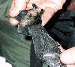 Collecting data for bat inventory and monitoring project |
The research efforts concentrated on sampling sites in low elevation forests, riparian areas, subalpine habitats, buildings and caves. Roger Christopherson and other staff and volunteers collected data with ultrasonic bat detectors and using capturerelease methods. Information collected included species identity, sex, age, reproductive condition, weight, measurement of several morphological characteristics, and recordings of each bat's echolocation calls.
During this study, biologists documented eight of the 12 species of bats predicted to occur in the park. They captured five species and detected three more by ultrasonic echolocation recordings. A ninth species, the Townsend's Big-Eared Bat, was found adjacent to the park boundary. In addition, the largest known nursery colony within NOCA was located in one of the park's buildings.
List of bats documented within NOCA:
Order Chiroptera, Family Vespertilionidae
California myotis Myotis californicus
Yuma myotis Myotis yumanensis
little brown myotis Myotis lucifugus
long-legged myotis Myotis volans
western long-eared myotis Myotis evotis
silver-haired bat Lasionycteris noctivagans
big brown bat Eptesicus fuscus
hoary bat Lasiurus cinereus
Townsend's big-eared bat Corynorhinus townsendii
For more information, contact Wildlife Biologist Roger Christopherson, 360/856-5700 extension 308. Roger will be teaching the class Ecology of Insectivorous Bats of the Pacific Northwest, July 19-21, through North Cascades Institute. For information about this class call North Cascades Institute 360-856-5700 extension 209 or consult http://www.ncascades.org.
Stream Water Quality & Macroinvertebrate Research
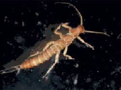 Bolshecapnia larva, a stonefly nymph found in lakes and ponds |
Benthic macroinvertebrate (BMI) communities are widely accepted and used for monitoring pollution and biotic integrity in aquatic systems. Benthic macroinvertebrates are bottom dwelling aquatic organisms that include insects, snails, clams, sponges, and worms.
Last year park staff collected physical and chemical data and BMI samples for 41 stream sections. Thirty of the sites were new sample locations and 11 were locations that had been sampled in previous years. We now have BMI data for 156 stream sections, and 21 sections have been sampled for multiple years. The large number of sample sites will provide the spatial coverage and meet sample size requirements necessary to accurately assess the biological condition of these streams.
We will sample 13 more sites this year and will collect environmental attribute data from these 13 plus 19 other sites. Environmental attribute data includes stream elevation, stream channel gradient, precipitation levels, catchment area covered by glaciers, and the area within the rain and snow zone. Sample processing, BMI identification work, data entry, and analysis are ongoing and will continue this year. Final completion of protocols is scheduled for 2003.
For more information, contact Aquatic Ecologist, Reed Glesne 360/856-5700 extension 369 or Chief of Resource Management, Bruce Freet 360/856-5700 extension 376.
Mountain Lakes & Ponds Monitoring Protocol
Major components of this study are to describe the benthic macroinvertebrate (BMI) communities that live in the shallow waters of each lake, describe species that respond to gradients of acidity and nutrient levels, and developing indices for monitoring lake water quality and biological integrity.
We finished identifying the BMI samples from lakes and ponds last year, and we have entered them all into a database. This year we will analyze the data, conduct peer review and develop final protocols for monitoring mountain lakes and ponds.
For more information, contact Aquatic Ecologist, Reed Glesne 360/856-5700 extension 369.
Glacier Mass Balance Monitoring
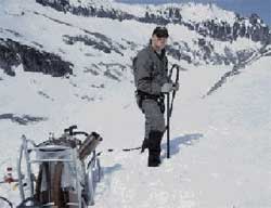 Jon Reidel using steam drill to place glacier monitoring stakes. |
For the 9th consecutive year park geologist Jon Riedel measured glacier mass balance on four glaciers in North Cascades National Park. Glacier mass balance is the difference between the winter accumulation of snow and the amount of snow and ice that melts over the summer. The glaciers represent a range in elevation from 8500' to 5700' and a range of climatic conditions from maritime to continental. Jon and his crew visit each glacier three times yearly to measure winter accumulation and summer melt. They take these measurements at a series of points down the centerline of each glacier surface to determine annual mass balance for the entire glacier.
Reflecting regional drought conditions, all of the glaciers lost more mass during the summer of 2001 than they gained in the previous two winters. Spring 2001 snow accumulation data and 2000 runoff estimates were published in the Washington Snow Survey report for June 2001. Full results will be published in a journal article this year, and a ten-year summary is planned for 2003. Protocols for glacier monitoring were published in an extensive report.
Jon has begun working with researchers from Mount Rainier and Olympic National Parks to start glacier monitoring programs in those parks.
Fiscal year 2002 will mark the 10th year of a glacier monitoring program at NOCA. In addition to monitoring the surface mass balance of four park glaciers, we will continue to support radiation and energy balance monitoring at three sites. We will also obtain new large scale Digital Elevation Models (DEMs) of the four glaciers monitored. A DEM is a detailed representation of surface elevations in digital form, like a topographic map that can be analyzed on a computer Geographic Information System (GIS). The glaciers were originally mapped from aerial photography and made into DEM form in 1993 (one was mapped in 1995). This process will be repeated with 2001 or 2002 aerial photography and we'll compare changes in glacier surface elevation, terminus position, and boundaries between the two DEMs.
Cooperators on this project include Seattle City Light, Natural Resource Conservation Service, Earthwatch Institute, and the US Geological Survey.
For more information, contact Geologist Jon Riedel 360/873-4590 extension 21.
Native Vascular Plants Inventory
North Cascades National Park (NOCA) is one of the most diverse parks within the North Coast and Cascades Network and probably one of the most diverse for plants in the national park system. NOCA extends from low elevation riparian corridors (400') to mountain peaks over 9,000'. Precipitation and temperature patterns also change along these elevation gradients. Currently, there are 1,627 species on the park's plant list. Olympic National Park has 1,187 plant species and Mount Rainier has about 900 species.
The goal of the species inventory program is to develop vascular plant lists for each park and to verify these lists at the 90% level; that is, obtain a specimen or find a mention in a scientific study or a reliable report for at least 90% of the species. Vascular plants are those plants that have a system of specialized conductive and supportive tissues. Since 1999, NOCA botanists have been collecting and documenting plants in databases set up by the Biological Resources Management Division of the National Park Service from information provided by the park. Currently, 529 species have no verification within the park. Park botanists will conduct field surveys this year to verify the park's species list at the 90% level. The surveys will focus on the habitats of rare species and on habitats little surveyed in the past.
The park species list includes 73 species listed by the Washington National Resources Office as threatened, endangered or species of concern. Only 17 of the 73 species have been documented within the park. We will be developing potential habitat maps of many listed species and searching these habitats to determine if any of the remaining 56 species occur within the park's boundaries. NOCA is also working with the Rare Care Program at the University of Washington to monitor known populations of listed species. Last summer two groups of volunteers helped monitor the status of two rare plant species. We hope to locate more populations and expand our partnership with this program in the future.
For more information, contact Botanist Mignonne Bivin 360/873-4590 extension 58.
Non-native Vascular Plants Survey
This year, national parks in the North Coast and Cascades Network are starting a combined effort to control and remove problem exotic plant species. There are approximately 271 exotic plant species in North Cascades National Park. Eight of these Jon Reidel using steam drill to place glacier monitoring stakes. are currently targeted as high priority for control efforts. Although informal surveys have been conducted recently in spot locations, no comprehensive surveys have been done in North Cascades since 1980. To develop a clear idea of where exotic plant populations are now, park botanists began abundance and distribution surveys in "sensitive areas" of Mount Rainier National Park and North Cascades National Park Service Complex during the summer of 2000.
Sensitive areas were defined as those most susceptible to exotic plant invasions: developed zones, trail corridors, road corridors, and riparian areas. These are areas with the most disturbance of the natural vegetative cover and the greatest amount of human activity that could bring in exotic plants. A statistician from the University of Washington helped create a sampling design. A field crew worked in both parks and inventoried about 150 plots. Data will be compiled this summer. In 2002, survey work will be completed in North Cascades and Mount Rainier National Parks and surveys will be initiated in Olympic National Park.
For more information, contact Botanist Mignonne Bivin 360/873-4590 extension 58.
A Photographic Mushroom Survey
Several years ago Robert Morgan, a photographer and park volunteer, obtained a $14,500 grant from the Skagit Environmental Endowment Commission to conduct a photographic survey of fungi in North Cascades National Park and neighboring Ross Lake and Lake Chelan National Recreation Areas. Prior to Morgan's effort, few of the park's estimated 600- 800 mushroom species had been documented. Completing his two-year survey in 2001, Morgan documented 125 mushroom species while covering 5% of the park's total area. The University of Washington assisted with species identification, confirming the discovery of one rare species.
Morgan recorded the date, time, weather, location, and soil temperature for each photograph, then submitted the original slides and related data to the park's museum collection. Work has begun to convert information from the standard National Park Service (NPS) format for museum collections (ANCS+) to the NRSpecies database format, including geo-referenced locations of each record for use with GIS applications. The 340 slides have been copied and assembled in three reference notebooks for use by NPS interpreters, North Cascades Institute, and British Columbia Parks. They have also been placed on CD-ROMs for museum loan, website use, and further investigation by researchers.
For more information, contact Chief of Resource Management Bruce Freet 360/856-5700 extension 376.
Air Quality Monitoring
Since 1980, North Cascades National Park has cooperated with the United States Geological Survey, several universities, industry and other agencies to monitor air quality and its impacts. The data collected helps researchers to better understand how pollutants affect park resources. The North Cascades air quality monitoring program includes several data collection systems: an aerosol sampler inhales air continuously. Its filters are analyzed weekly for substances such as sulfates, nitrates, organic carbon and particulates. An acid rain monitor measures the acid content of precipitation. An ozone monitor measures ground level ozone. The monitoring station is located near Ross Dam.
For more information, contact Geologist Jon Riedel 360/873-4590 extension 21.
Human Impacts on Wilderness (Limits of Acceptable Change)
In 2001, staff entered data about human impacts from hiking, camping, and climbing in wilderness areas of North Cascades National Park into Access and GIS park databases. We reviewed previous research on the ecological effects of recreational use on soils and soil organisms. Field surveys of impacted campsites were conducted in Mount Rainier and North Cascades National Parks. Previously these sites had been documented in terms of soil and plant loss. In 2001 we collected data on the diversity of plant species, characteristics of the soil, and soil biota. This data will be used to identify ecological effects of recreational use and research needs.
In 2002 a network-wide workshop will be conducted to review status of wilderness and recreational use plans and research needs. A summary of all indicators and standards will be presented with reference to the origin of the standard. Ecological context of indicators and standards will be discussed and research needs will be identified. Social science research will also be discussed. Field inventories and research projects will be identified in the workshop and initiated in the 2002 field season.
For more information, contact Science Advisor Regina Rochefort 360/856-5700 extension 254.
Restoration of Goodell Creek Gravel Pit
North Cascades National Park has begun an ecological restoration on about 0.6 acres of the 6-acre former gravel pit near the town of Newhalem. The general goals of this project are to restore a functioning low-elevation riparian forest to the site of a discontinued gravel mine, to control exotic plants species, and to learn how to accelerate the long-term restoration of a forest ecosystem. The project site is located on the eastern bank of Goodell Creek, a tributary of the Skagit River, in the Ross Lake National Recreation Area (part of North Cascades National Park). Gravel mining operations ceased approximately 20 years ago. The site has since been a construction staging and aggregate storage area for the Washington Department of Transportation, Seattle City Light, and the National Park Service. The section to be restored occupies part of a riparian terrace within the creek's 100-year flood plain. The restoration project will create a buffer zone along the creek providing a continuous wildlife corridor along the east bank of Goodell Creek and improving salmon habitat.
Graduate students Rodney Pond and Sean Smukler from the University of Washington are conducting research to determine how revegetation with native plants can be accelerated using soil amendments and mulches. Research objectives will include two different soil treatments, three mulch treatments, and the use of transplants and native seed mixes. The soil at the site is basically sand and gravel with very little organic material. Since most riparian areas contain organic matter in their soils, we decided to add organic material to half the site to see if this would accelerate the growth of transplanted trees and native seeds. Then three mulch treatments were also used on each half of the site: straw, wood chips, and no mulch. We will monitor the effects of both the mulches and soil amendments with respect to native and non-native plant establishment and growth. Although this site will be monitored for 5-10 years, we are hoping to see the effects of the different treatments in the summer of 2002.
For more information, contact Science Advisor Regina Rochefort 360/856-5700 extension 254.
NATURAL RESOURCES EDUCATION
North Cascades National Park (NOCA) educators have been sharing research information with local students through outreach and on site programs.
During six consecutive Friday afternoon sessions this winter, elementary school students learned about some of the research being carried out in NOCA. Learning-based activities, word games, and costumes were used to teach students about the winter population of Skagit River bald eagles, salmon, bats, insects, and the biodiversity of NOCA.
A new children's skit, created by Interpreter Todd Burley, has been met with great success at the North Cascades Visitor Center. Students, parents, and chaperones assume new identities on center stage to learn about the life cycle of salmon and their dependence on certain abiotic and biotic elements of the Skagit River Watershed.
For more information, contact Education Specialist Paula Ogden 206-386-4495 extension 19.
Women's Understanding of Place: a graduate thesis
Tina Copeland, a former seasonal interpreter at Stehekin in the Lake Chelan National Recreation Area, recently completed her graduate thesis. Her work is a narrative-based study of oral testimony that explores the relationships nine women have to their home — in this case, the isolated Stehekin Valley in North Cascades National Park's Lake Chelan National Recreation Area.
Tina writes, "Our understanding of place is more than the sum of its geologic, biotic and abiotic parts; these parts taken alone would simply equal a location. The human dimension — the affective awareness of dwelling in that location and feeling those parts of nature, help to create place".
Her work results in "a rich discussion of how a remote isolated life has affected women's valuing of wilderness, solitude and spirituality and their ability to share these connections with each other and the outside world". (Tina Copeland, graduate thesis, October 2001)
For more information, contact Stehekin District Interpreter Nancy Holman 360-856-5700 extension 340, then extension 13.
To Learn More
To learn more about North Cascades National Park and some of these research projects, explore the website http://www.nps.gov/noca.
noca/resource-mgt/may-2002.htm
Last Updated: 04-Sep-2002