|
North Country National Scenic Trail MI-MN-ND-NY-OH-PA-VT-WI |
|
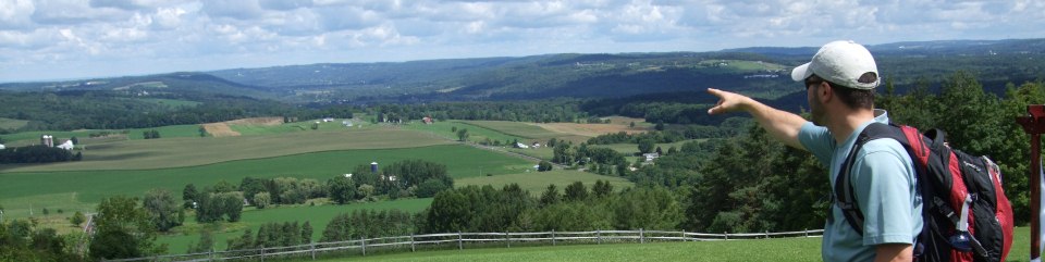 NPS photo | |
Our northern tier of States offers some of the most outstanding scenic beauty to be found anywhere in America. The "North Country" is a land of diversity whose beauty is accentuated by its distinctly changing seasons. As you travel the North Country, the hills and valleys, lakes and streams, show how massive continental glaciers molded the landscape more than 10,000 years ago. Historic sites along the way tell the story of how America was settled and grew as a nation.
The North Country National Scenic Trail provides a way to enjoy these natural and cultural resources. Come to the land of clear-flowing streams . . . the red and gold display of autumn . . . winter's fairyland of snow-carpeted landscapes . . . to tallgrass prairies and distant horizons. Listen to the echoes of voyageurs' songs and watch for the northern lights as you lie in your tent beside a serene lake. As you enjoy each segment of the trail, you will take with you lasting memories of the North Country.
Your Adventure Starts Nearby
Threading its way across our landscape, the North Country National Scenic Trail (NST) links outstanding scenic, natural, recreational, historic, and cultural areas in seven of our northern States. Some portions of the trail invite easy walking, while others provide challenge, but everywhere the trail offers adventure.
Unlike the Appalachian, Pacific Crest, and Continental Divide NSTs, which follow mountain ranges, the North Country NST journeys through a variety of environments in the northeastern and north central United States. From the grandeur of the Adirondack Mountains in New York, it meanders westward through the hardwood forests of Pennsylvania, through the countryside of Ohio and southern Michigan, along the shores of the Great Lakes, and through the glacier-carved forests, lakes, and streams of northern Wisconsin and Minnesota. Its western terminus lies in the vast plains of North Dakota.
The North Country NST answers the call of hikers for pathways on which to escape from hectic lives—for a chance to explore America at a walking pace, rather than at freeway speeds. North Country Trail users are discovering places where they can look out over forested hills and valleys, places where the beautiful work of nature's hand appears undiminished, and places where our rich and diverse cultural heritage can be understood, enjoyed, and relived.
The North Country Trail exists as much for the enjoyment of the casual walker as it does for the challenge of those who will travel its entire length. Whether you use it for an afternoon of walking, a day of cross-country skiing, or a week or month of backpacking, you will find adventure as you encounter and explore forested pathways, marshes and bogs, waterfalls, sand dunes, tallgrass prairies, old logging railroad grades, lighthouses, Revolutionary War forts, and small rural communities. From the Missouri River in North Dakota to the shore of Lake Champlain in New York, the diverse features along the trail will help users understand how the land was formed, how it has been settled, and how it has been used and altered by humans.
This diversity of landscapes and scenic and historic features along the North Country NST is perhaps its most appealing quality. Large areas of publicly owned lands, such as national forests, major State parks and forests, and Adirondack Park in New York, offer wilderness and near-wilderness experiences. These remote sections of the trail will be especially enjoyable to those who value the solitude of such areas. A journey through these remote areas also rewards trail users with outstanding scenery, such as in Pictured Rocks National Lakeshore, Michigan, where 44 miles of the trail follow the Lake Superior shoreline with its Grand Sable Dunes, Twelvemile Beach, and Pictured Rocks cliffs.
Somewhat in contrast to the remote sections are the portions of the trail which pass through or near many small villages and towns and a few large cities. These communities offer access to the trail, lodging and other accommodations, opportunities for resupply for long-distance users, and interesting cultural features associated with their history.
Water has left a spectacular imprint on the North Country. Glacial ice sculpted the basins of our Great Lakes, cut valleys, and left behind numerous rivers and lakes. Today, water is still at work carving our landscape. The North Country Trail takes hikers to scenic gorges such as Watkins Glen in New York, Slippery Rock Creek in Pennsylvania, Old Man's Cave in Ohio, and the St. Louis River in Minnesota. The sight and sound of waterfalls will be a frequent greeting to trail users, particularly in Upper Michigan, Wisconsin, and Minnesota. The North Country's rivers and lakes will become favorite companions, especially at the end of a day when camp is made.
The scenic beauty of the natural resources along the trail is complemented by the many cultural features. Trail users can pause and marvel at the prehistoric Indian earthworks along the trail in Ohio. All along the trail. North Country NST travelers are reminded of the original inhabitants of this region by the many locations that still carry names given to them by American Indians and recorded by European explorers and traders.
No less marvelous than the ancient Indian earthworks are marvels of modern engineering to be encountered along the trail, such as Michigan's 5-mile-long Mackinac Bridge, spanning the waters between its two peninsulas, or North Dakota's Garrison Dam near the western terminus of the North Country NST. In between our ancient yesterdays and the present is a spectrum of history that can be enjoyed along the North Country Trail through visible remnants and interpretive facilities—historic forts, canals, lighthouses, grist mills, logging and mining camps, portage routes of the voyageurs, and much more. All are waiting to be explored and to tell their story to trail users.
The North Country NST is becoming one of our country's major trails, offering unparalleled opportunities to enjoy a cross-section of America's rich natural and cultural heritage. Come visit the North Country... by trail. Whether on foot, snowshoes, or skis, great adventure lies just ahead.
Creating and Completing the Trail
Through the combined efforts of many people, the 4,600-mile North Country National Scenic Trail (NST) will become the longest continuous hiking trail in the United States. Although it will take many years to complete, trail users are already enjoying over 2,600 miles open to public use. Completed segments vary in length from 1 mile to over 300 miles.
The North Country Trail began as a U.S. Forest Service proposal in the mid-1960's. In 1968, Congress passed the National Trails System Act designating the Appalachian and the Pacific Crest Trails as the first national scenic trails. The Department of the Interior was directed to study other proposed routes, including the North Country Trail, as potential national scenic trails. The 1975 study report recommended creation of the North Country NST as a component of the National Trails System.
In March 1980, Congress passed the necessary legislation and brought national attention to the outstanding scenic and recreational values of the trail and its route. The National Park Service administers the trail in cooperation with other Federal, State, and local agencies, private organizations, and individuals, including many generous landowners. Its administrative responsibilities include overseeing the planning, development, protection, and maintenance of the trail; coordinating and assisting the activities of the many public and private partners; and providing technical and financial assistance to cooperating interests.
The National Trails System Act requires that the actual work of developing, managing, and protecting the various segments of the trail be a cooperative effort involving many agencies at all levels of government as well as private interests. Private volunteer trail organizations and individuals will have to accomplish most, if not all, of the work of developing and maintaining segments of the trail.
Over 1,900 miles of trail have been certified by the National Park Service as official segments of the North Country NST. Certification indicates the segment is developed and managed in accordance with approved plans and trail standards, and entitles the segment to be marked with the official trail emblem. Several hundred additional miles of uncertified segments are open to public use.
Your Help Is Needed
The story of the North Country Trail is being written by dedicated public officials, citizen volunteers, and private landowners captivated by the vision of the trail and the many experiences it will offer to those who follow it in quest of the North Country's scenic treasures. You can help write that story by becoming involved as a volunteer, joining in the effort to build, promote, and maintain sections of the trail.
Several major trail organizations assist the National Park Service and other public land managing agencies in developing, protecting, and maintaining the trail. The North Country Trail Association was formed in 1981 to organize and coordinate the massive volunteer effort necessary to establish and maintain segments across private lands, as well as assist public agencies in establishing segments on their lands. The association works closely with the National Park Service in promoting development, protection, and use of the trail.
The National Park Service and the association work closely with other organizations dedicated to building and maintaining the North Country Trail in their States: the Border Route Trail Association and Superior Hiking Trail Association in Minnesota, the Buckeye Trail Association in Ohio, and the Finger Lakes Trail Conference in New York. Contact information for each of these groups is below.
You can help establish, promote, and protect the North Country NST by joining or supporting the efforts of these organizations or other local groups working on the trail. Membership and other information can be obtained by going to their websites. Landowners along the route of the trail can make a significant contribution by giving permission for the trail to cross their lands or by donating or selling lands or easements for the trail. Financial contributions can help support and accelerate the activities associated with establishing and maintaining the trail. Donations of money, land, and easements may qualify as tax-deductible gifts. For more information, contact the National Park Service or the cooperating organizations.
Footprints of History in the North Country
Blocks of sod cut from the deep topsoil of the grasslands were used by settlers to build temporary homes on the treeless plains of America's heartland. These "soddies" offered shelter from the intense heat or bitter cold until lumber could be imported from the flourishing mills around the Great Lakes.
Logging was winter work as lumber crews cut the great pines and loaded them onto sleds. The trail was iced with water to enable horses to pull immense loads to staging areas along rivers for the spring log drives. Contests developed between crews to see wh at camp coud stack and haul the heaviest load. One prize load weighed over 50 tons.
As the twentieth century was dawning, the booming lumber industry in the Great Lakes area was beginning to die out. Cutover lands and remaining timberlands were promoted and sold as high quality farmlands. Many heartbroken families abandoned their land when their persistent efforts to farm these sandy soils proved fruitless.
Immigrants from Cornwall, England and other areas of Europe brought their mining knowledge to America. Their skills found ready employment underground such as in the iron and copper mines of northern Michigan, Wisconsin, and Minnesota in mining and other fields of employment, the wages earned by the immigrants enabled them to send passage for numerous relatives to join them.
The opening of New York's Erie Canal in 1825 spurred the development of vast networks of canals in the Northeast, Mid-Atlantic, and Great Lakes regions. Marvelous feats of engineering, they flourished as water highways to carry immigrants westward and goods to Eastern markets until the advent of the railroad. Many remnants and restored sections can be enjoyed along the trail today.
Enjoying the Trail
 (click for larger map) |
Over 200 public agencies and private interests are participating in the development and management of the North Country National Scenic Trail (NST). Trail widths and surfaces, campsites and other support facilities, and regulations for using the trail vary from one trail segment to the other.
Trail Marking. Official segments of the North Country NST are signed with a marker. These are supplemented by other types of markings, such as paint blazes and routed wooden signs that provide distance and directional information. Other segments are marked similarly, but lack the official North Country NST symbol.
Permitted Uses. All segments of the North Country NST are open to travel by foot for walking, hiking, and backpacking. Other non-motorized uses. including cross-country skiing, snowshoeing, and jogging, are generally permitted. On a few segments, bicycling or horseback riding is allowed where the trail has been specifically designed to withstand such use. For information on which segments are open to other uses besides foot travel, contact the National Park Service or the local managing authority.
Fees and Permits. Hiking on the North Country NST is free and requires no permit. However, there may be fees and/or permits in connection with accessing the trail, such as state park entrance fees, or using certain facilities, such as developed campsites in public parks and forests. Some backcountry campsites may also require a permit, such as those along the North Country Trail in Pictured Rocks National Lakeshore in Michigan's Upper Peninsula. Users should check with managing authorities in advance to determine if permits and/or fees are required.
Camping. For day-hikers, there are many campgrounds located along and near the North Country NST. For multi-day backpackers, these same campgrounds can be used. Additionally, some managing authorities permit camping anywhere along the trail. As the trail is being developed, there are completed segments which as yet have no places to camp legally. All users are urged to plan their trip in advance to assure themselves proper overnite accommodations. Above all, avoid trespassing and violating private property rights.
Interpretive Facilities. Various types of interpretive facilities-visitor centers, museums, exhibits, signs, etc.—are located at scenic and historic sites along the trail.
Fishing. A State fishing license is required in each State for fishing in lakes and streams along the trail.
Hunting. Many public and private lands through which the North Country Trail passes are legally open to hunting during the proper seasons. It is not intended that passage of the trail through these lands should in any way lead to their closure to hunting. Similarly, passage of the trail through lands closed to hunting does not open them in any way to hunting. In general, the trail will remain open to use during hunting seasons. However, some segments of the trail may be closed to use during some hunting seasons by the managing authorities responsible for those segments. Trail users should check in advance with the managing authority regarding use of specific trail segments during hunting seasons. Trail users are encouraged to wear "blaze orange" while using segments open to hunting.
Trail Courtesy. North Country Trail users are urged to show their appreciation for the voluntary public and private efforts to develop and manage the trail by using it and related facilities properly and complying with any applicable rules and regulations. Users should be especially careful to respect the rights of private property owners—those who have generously allowed the trail to cross their land and those who live adjacent to publicly owned segments. Please stay on the trail, especially when crossing private lands.
Administration. The North Country NST is administered by the National Park Service in cooperation with many other public agencies, private organizations, and landowners. Additional general information about the trail can be obtained by contacting the North Country National Scenic Trail, National Park Service, P.O. Box 288, Lowell, Ml 49331; www.nps.gov/noco. Detailed information about specific segments can be obtained by contacting the sources below.
Information on Completed Segments
The information in this brochure is not sufficiently detailed to enable you to actually use completed segments of the trail. You will need more detailed information from the sources below. The North Country Trail Association, Finger Lakes Trail Conference, Buckeye Trail Association, and Superior Hiking Trail Association have online "trail shops" selling maps and other trail related items. Their websites have useful information for hikers. Trail information is also available from the sources corresponding to the numbers on the map. Information about camping and other matters within the State parks, forests, and wildlife areas along the trail can be obtained from the corresponding agencies in the list below.
Trailwide and General Information
North Country Trail Association
229 East Main Street
Lowell, Ml 49331-1711
www.northcountrytrail.org
hq@northcountrytrail.org
facebook.com/northcountrytrail
National Park Service
P.O. Box 288
Lowell, Ml 49331-0288
www.nps.gov/noco
North Dakota
North Dakota Parks and Recreation Department
www.parkrec.nd.gov
North Dakota Game and Fish Department
gf.nd.gov
U.S. Army Corps of Engineers
www.mvp.usace.army.mil/recreation
North Dakota Forest Service
www.ndsu.edu/ndfs/state_forest_recreational_opportunites/sheyenne_river_state_forest
Sheyenne National Grassland
www.fs.fed.us/r1/dakotaprairie/
Minnesota
Minnesota Department of Natural Resources
www.dnr.state.mn.us/index.html
Chippewa National Forest
www.fs.usda.gov/chippewa
Superior National Forest
www.fs.usda.gov/superior
Border Route Trail Association
www.borderroutetrail.org
info@borderroutetrail.org
Superior Hiking Trail Association
www.shta.org
hike@shta.org
Wisconsin
Wisconsin Department of Natural Resources
dnr.wi.gov/orcj/land/parks/specific/northcountry
Chequamegon National Forest
www.fs.usda.gov/cnnf
Michigan
Michigan Department of Natural Resources
State Parks
State Forests
www.michigan.gov/dnr
Ottawa National Forest
www.fs.usda.gov/ottawa
Hiawatha National Forest
www.fs.usda.gov/hiawatha
Pictured Rocks National Lakeshore
www.nps gov/piro
Manistee National Forest
www.fs.usda.gov/hmnf
Ohio
Ohio Department of Natural Resources
State Parks
State Forests
www.ohiodnr.com
Northwestern Ohio Rails to Trails Association
www.wabashcannonballtrail.org
Buckeye Trail Association
www.buckeyetrail.org
Ohio Historical Society
www.ohiohistory.org
Wayne National Forest
www.fs.usda.gov/wayne
Pennsylvania
Pennsylvania Bureau of State Parks
www.dcnr.state.pa.us/stateparks
Allegheny National Forest
www.fs.usda.gov/allegheny
New York
NYS Office of Parks, Recreation and Historic Preservation
parks.ny.gov
NYS Department of Environmental Conservation
www.dec.ny.gov/lands/309.html
Finger Lakes Trail Conference
www.fltconference.org
Finger Lakes National Forest
www.fs.usda.gov/fingerlakes
Description of the Trail Route
North Dakota — 475 miles
The Missouri River and Lake Sakakawea State Park mark the western end of the North Country National Scenic Trail. The river was the route of the famous Lewis and Clark Expedition of 1804-06 and is today a National Historic Trail. The North Country Trail follows the shores of Lakes Sakakawea and Audubon and then continues along the Garrison Diversion Project canals and through Lonetree Wildlife Management Area. Reaching the Sheyenne River, the trail follows the western shore of Lake Ashtabula with its myriad waterfowl and follows the scenic forested river valley southward to Fort Ransom State Park and Sheyenne State Forest. Hikers will enjoy the segment in Sheyenne National Grassland—a 71,000-acre remnant of the tallgrass prairie and oak savanna. The trail route continues eastward to the Red River Valley and Fort Abercrombie State Historic Site, before reaching the Minnesota State line. As trail users traverse the scenery of our northern prairies they will thrill to the sight of great flocks of geese, ducks, and sandhill cranes.
Minnesota — 775 miles
Rivers, lakes, and forests characterize the North Country Trail for much of its route through Minnesota. From the North Dakota State line, it extends eastward before turning northeast as it passes through Maplewood State Park. Hikers can enjoy a 150-mile completed section traversing Tamarac National Wildlife Refuge, White Earth State Forest, Itasca State Park, Paul Bunyan State Forest, and Chippewa National Forest. At Itasca State Park, a short side trip will allow trail users to confront the mighty Mississippi River at its origin as it flows from the forested shore of beautiful Lake Itasca. Hikers will enjoy the remote solitude of the Boundary Waters Canoe Area Wilderness while traveling the Kekekabic and Border Route Trails and the spectacular views of Lake Superior along the Superior Hiking Trail. At Jay Cooke State Park near Duluth, a trail suspension bridge crosses the rock-lined rapids as the St. Louis River plunges over exposed rock outcroppings of the Laurentian Shield.
Wisconsin — 200 miles
The initial 40 miles of the route pass through a diverse landscape of wetlands and wooded ridges before reaching the beautiful Saint Croix River, a National Scenic Riverway. South of Solon Springs, hikers will pass through the Douglas County Wildlife Area—a "pine barrens" managed for sharptail grouse and other prairie species. Soon after reaching Brule River State Forest, the route passes through Brule Bog on a long boardwalk, allowing an up-close experience with a white cedar bog. The trail continues north and east through the forest and county forest lands, providing a connection to the 60-mile segment in Chequamegon National Forest. This segment helped give birth to the concept of the North Country Trail and gave its name to the entire trail. East of the forest, the trail meanders through Copper Falls State Park with its many beautiful waterfalls. Routes through the Gabbro-Penokee-Gogebic Iron Range connect the North Country Trail to Michigan.
Michigan — 1150 miles
From its point of entry near Ironwood, the North Country Trail route soon enters Ottawa National Forest and Porcupine Mountains Wilderness State Park. Rivers, waterfalls, forested hills and ridges characterize the trail. Laughing Whitefish Falls and numerous other falls provide outstanding scenery as the trail continues eastward to Munising and Pictured Rocks National Lakeshore. Here, the 44-mile North Country Trail along the rock bluffs and sandy shore of Lake Superior provides outstanding vistas as well as primitive camping and hiking experiences. The trail continues eastward along the lake through Muskallonge Lake State Park before turning south at Tahquamenon Falls State Park, where the second largest waterfall east of the Mississippi River and many smaller falls await the hiker. South of the park, the trail passes through Hiawatha National Forest on its way to the Straits of Mackinac. Trail users will find a side trip to Mackinac Island enjoyable.
Use of a shuttle is necessary to cross the spectacular 5-mile-long Mackinac Bridge except on Labor Day morning during the annual "Bridge Walk." The log stockades of Fort Michilimackinac stand guard at the tip of the Lower Peninsula as a living history display of French and British history in the region. From the fort, the trail heads down the western side of the peninsula passing through Wilderness State Park, State forest lands, and the scenic Jordan River Valley. Continuing southward, the trail follows a portion of the Shore-to-Shore Riding-Hiking Trail before entering Manistee National Forest. The sandy floor of the Manistee provides easy walking southward toward Grand Rapids. Passing to the east, the trail reaches the city of Lowell and the headquarters of the North Country Trail Association. The trail continues southward through Yankee Springs State Recreation Area and follows a portion of Battle Creek Linear Park. From there, the trail heads southeast toward Ohio, passing through primarily agricultural lands as well as a variety of State and local recreation areas.
Ohio — 1050 miles
The North Country Trail makes a U-shaped sweep through Ohio. For much of this route, it follows the Buckeye Trail. In western Ohio, it follows the remnants of the old Miami and Erie Canal. Passing through the heart of Dayton, trail users will enjoy access to Dayton Aviation Heritage National Historical Park, the Wright Brothers Memorial, the Air Force Museum, and Five Rivers Metroparks. Near Springfield, the Little Miami Scenic Park rail-trail provides the route south to the outskirts of Cincinnati. Developed and maintained by a combination of State, county, and municipal agencies, the trail parallels the Little Miami National Scenic River, Eastward from Cincinnati, the trail route crosses long stretches of private land before entering a succession of State and national forest lands. Along the way are State memorials commemorating prehistoric Indian cultures and the rock bluffs and caves of the scenic Hocking Hills region. At Marietta, the trail turns north to follow the scenic Little Muskingham River through Wayne National Forest. Continuing north, it links a series of reservoirs and recreation areas, eventually reaching the historic communal settlement of Zoar. There the trail turns eastward to Pennsylvania, paralleling Little Beaver Creek, a national scenic river.
Pennsylvania — 265 miles
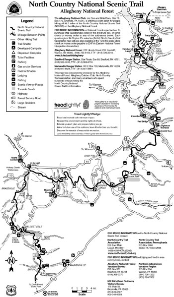
Natural and cultural features are blended together along the trail as it crosses northwestern Pennsylvania. The gorge of Slippery Rock Creek provides a scenic setting for the trail and a historic operating grist mill in McConnells Mill State Park. The Glacier Ridge Trail segment in nearby Moraine State Park reminds users of the origin of the surrounding landscape. From these parks, the trail route heads northeastward, paralleling portions of the Allegheny and Clarion Rivers. The route intersects the Baker Trail and follows it through Cook Forest State Park and State forest lands. The 87-mile segment in Allegheny National Forest meanders northward through scenic rolling hills and stream valleys, eventually reaching New York along the shore of Allegheny Reservoir.
New York — 625 miles
The trail enters New York in Allegany State Park and begins its eastward course following 420 miles of the Finger Lakes Trail. The rolling glacial topography of the Finger Lakes Region provides numerous scenic vistas of distant hills, valleys, and lakes. Along the trail are the canyons of the Genesee River in Letchworth State Park (via a short side trail) and the colorful gorges and plunging waterfalls of Watkins Glen State Park. Near Cortland, the trail turns northward, eventually intersecting the towpath trail in Old Erie Canal State Park. It follows the towpath to the city of Rome and Fort Stanwix National Monument, a reconstructed Revolutionary War fort. From Rome, the trail route follows the course of the Old Black River Canal to Boonville and then enters the 6-million-acre Adirondack Park with its lakes and streams nestled among forested mountains. Outstanding experiences await the hiker in this remote and primitive region. The eastern end of the North Country Trail is reached at Crown Point State Historic Site on the shore of Lake Champlain.
Source: NPS Brochure (2012)
|
Establishment North Country National Scenic Trail — March 5, 1980 |
For More Information Please Visit The  OFFICIAL NPS WEBSITE |
Documents
A Handbook for Trail Design, Construction and Maintenance: North Country National Scenic Trail (August 1996)
Comprehensive Plan for Management and Use, North Country National Scenic Trail, NY-PS-OH-MI-WI-MN-ND (September 1982)
Foundation Document Overview, North Country National Scenic Trail, ND-MN-WI-MI-OH-PA-NY (January 2015)
Map, North Country National Scenic Trail (undated)
Superintendent's Compendium (Mark Weaver, 2017)
The North Country National Scenic Trail: Information for Users and Route Description (April 1985)
noco/index.htm
Last Updated: 01-Jan-2025