|
HISTORIC HIGHWAY BRIDGES OF OREGON
|
|
Rogue River (Rock Point) Bridge (1920), old Pacific Highway near
Gold Hill, Jackson County
HISTORIC HIGHWAY BRIDGES
HISTORIC HIGHWAY BRIDGES
This section of the document presents the historic highway bridges in Oregon. The bridges identified in the ODOT study, as well as the bridges previously determined eligible for or listed on the National Register of Historic Places, are included. Contemporary photography and descriptive information on all 145 bridges highlight this section. The historic bridges are presented in four groups:
Study Identified Bridges
Old Columbia River Highway Bridges
Covered Bridges
Other Historic Bridges
Each of these groups of historic bridges is discussed in the introductory material for each section. (A summary list of the bridges is in Figure 20.)
|
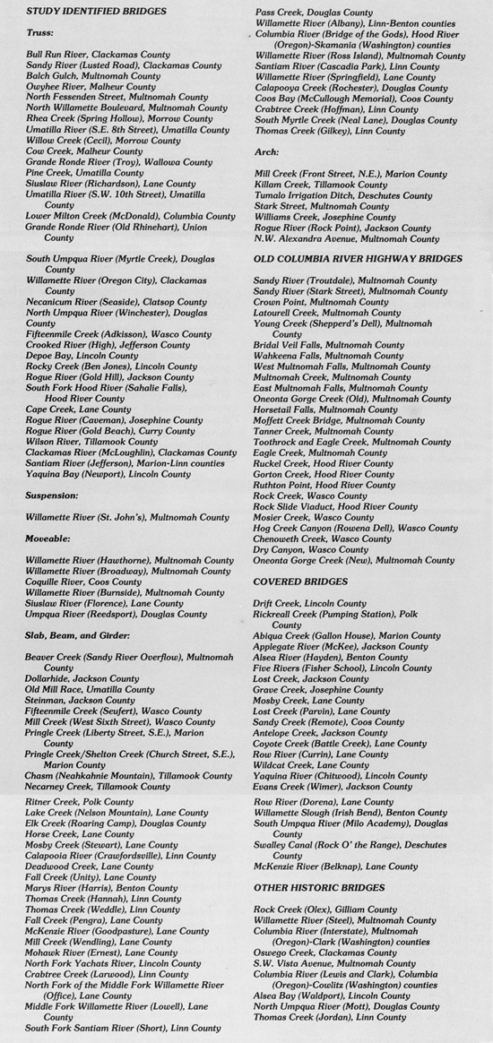
| FIGURE 20. History Highway Bridges of Oregon. The historic highway bridges in Oregon determined eligible for or listed on the National Register of Historic Places are listed below in the order of presentation in this section of the study report. |
The 145 bridges in this section are important examples of the bridge-building tradition in Oregon and constitute a valuable legacy to the art, engineering, and technology of bridge construction. By being National Register listed or eligible, these bridges are recognized as historically significant and valuable contributors to the cultural heritage of the state.
The historic bridges illustrated in this document are distributed throughout the state. The largest proportion is in the populated urban counties of the Willamette Valley, particularly Multnomah County (31 bridges) and Lane County (22 bridges). Ten counties, many of which are in eastern Oregon, presently have no National Register bridges. (Refer to Appendix C for information on the location of the historic bridges, as well as statistics on ownership and age.)
As defined by the engineering principle used in the center or main span, the most numerous of the historic bridges are the timber trusses (covered bridges), reinforced concrete arches, and slab, beam, and girders. (Additional information on the specific structural types and examples in Oregon is found in Appendix D.)
The historic highway bridges were constructed from 1894 to 1966. Oregon has only ten historic highway bridges built before 1910. Over half (64 percent) of the historic bridges were constructed in the 1910s and 1920s. The ownerships of the historic bridges vary. The counties own the largest number (43 percent), with the Oregon Department of Transportation second, owning 38 percent of the bridges. The cities own the third largest group, 8 percent of the historic bridges. Nine of the highway bridges, mostly covered bridges, are privately owned.
STUDY IDENTIFIED BRIDGES
The 68 bridges in this group were evaluated and identified as historically significant in the ODOT historic bridges study. The thematic group consists of public highway bridges in Oregon, constructed between 1894 and 1939. Each of these bridges has undergone thorough examination, review, and research concerning the bridge's design, designer, age, technology, attention to detail, site appropriateness, and association with historic events and persons. A professional review team, consisting of ODOT personnel, the State Historic Preservation Office staff, and public volunteer members, evaluated the inventory bridges against the criteria for eligibility to the National Register.
The State Historic Preservation Office concurred that the highway bridges were National Register eligible. The bridges were subsequently determined eligible by the Keeper of the National Register as the Historic Highway Bridges of Oregon Thematic Group.
The study bridges were evaluated by comparing and contrasting individual bridges with similar bridges of the same structural type and approximate age. Accordingly, the bridges in this section are presented by structural type and are in the following order:
Truss
Arch
Suspension
Moveable
Slab, Beam, and Girder
Within these classifications, the structures are arranged chronologically by the date construction.
|
| FIGURE 21. This perspective drawing of the Yaquina Bay Bridge at Newport, one of the study-identified bridges, was made by F.G. Hutchinson, graphics artist with the State Highway Department, in 1936. |
TRUSS BRIDGES
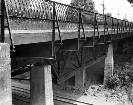
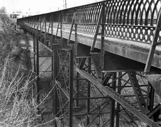
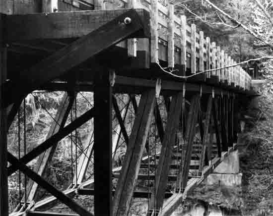
In its simplest form, a truss is a structural frame based on the geometric rigidity of the triangle. A truss bridge consists of a framework of members forming triangles and functions as an "open" beam or cantilever. The connecting truss members of a bridge, acting in tension, compression, or both, form a rigid structure capable of supporting not only the weight of the truss, but the applied load. Truss bridges are usually of three basic designs, as illustrated at right—deck truss, pony truss, and through truss. The nomenclature for the component members of a representative through truss is shown in the glossary.

|
Despite Oregon's late settlement relative to much of the rest of the country, its highway system includes an impressive collection of truss bridges, ranging from 1894 wrought iron structures to nationally-recognized cantilever bridges. About 350 truss bridges are on Oregon's highway system, 217 of which were constructed prior to 1941 (Appendix D). The truss form, once a common bridge type, is rapidly disappearing due to the superior economic advantages of reinforced concrete structures.
Several distinct configurations of trusses are represented in Oregon. Examples of rare types, such as the queenpost and the half-hip Pratt trusses, are present, as well as the more common Pratt, Parker and Warren configurations.
Rare and obsolete bridge construction techniques are evident in the 25 pin-connected highway truss bridges revealed by the study. Eleven of the 25 pin-connected trusses are National Register-eligible bridges and are shown on the following pages. (Nine pin-connected trusses are reserve bridge in Appendix E.) These early pin-connected metal trusses occasionally exhibit wrought iron members, portal messages (unique to the "catalog" prefabricated bridges), and ornate lattice railings. The riveted truss technology displaced pin connections during the early part of the 20th century and now forms the bulk of the truss population. The riveted trusses also include some rare and interesting forms, including the double-intersection Warren.
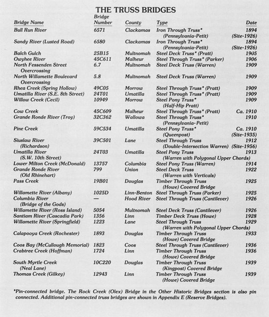
Twenty-seven truss structures were identified as significant and are presented in the following pages.
|
 | ||
| Structure Number 6571 | Constructed - 1894 (Site-1926) | |
| Bull Run County Road | Iron Through Truss (Pennsylvania-Petit) | |
| Bull Run, Clackamas County | Ownership - Clackamas County | |
|
BULL RUN RIVER BRIDGE The Bull Run River Bridge, pin-connected and incorporating both wrought iron and steel structural members, is of major significance to Oregon's bridge heritage. The use of wrought iron predates 1900 and represents a now obsolete material. The Bull Run River Bridge is one of only two bridges of its type on Oregon's highway system. The other is the Sandy River Bridge on Lusted Road, also in Clackamas County. The Bull Run River Bridge contains a Pennsylvania-Petit truss, 240 feet in length. The span was originally part of the Burnside Bridge across the Willamette River in Portland, built in 1894 by the Bullen Bridge Company. The truss portals contain nautical design elements, appropriate to its former location. The bridge was relocated to its present site in the Bull Run Reservoir area when the current Burnside Bridge was built in 1926. | ||
 | ||
| Structure Number 6580 | Constructed - 1894 (Site-1926) | |
| Lusted County Road | Iron Through Truss (Pennsylvania-Petit) | |
| Sandy vicinity, Clackamas County | Ownership - Clackamas County | |
|
SANDY RIVER (LUSTED ROAD) BRIDGE One of only two remaining pin-connected trusses utilizing wrought iron members on Oregon's highway system, the Sandy River Bridge is an important example of the technology of a bygone era of bridge building. The structure exhibits ornamentation virtually unknown on later truss bridges. The entrance portals of this 300-foot Pennsylvania-Petit truss have miniature ship's wheels and decorative flanges, derived from the structure's original location as part of the Burnside Bridge built in 1894 across the Willamette River in Portland. When the current Burnside Bridge was constructed in 1926, this is one of the two spans of the original bridge relocated to Clackamas County. The Sandy River Bridge is located in Dodge Park, a Clackamas County park. This bridge is located adjacent to a similar pin-connected wrought iron truss carrying water lines, built by the Bullen Bridge Company in 1893. | ||
 | ||
| Structure Number 25B15 | Constructed - 1905 | |
| N. W. Thurman Street, MacLeay Park | Steel Deck Truss (Pratt) | |
| Portland, Multnomah County | Ownership - City of Portland | |
|
BALCH GULCH BRIDGE This 160-foot Pratt truss is the oldest highway deck truss in Oregon and is one of only two remaining pin-connected deck trusses. The Balch Gulch Bridge is one of only four hanging truss designs in the state. Designed by J.B. C. Lockwood, a consulting engineer in Portland, the bridge was completed in 1905 at a cost of $35,000 and replaced a timber structure. The upgrading of N. W. Thurman Street, including the construction of this bridge, was completed in 1905 in preparation for the Lewis and Clark Exposition held nearby at the Guild's Lake area. The structure is supported by steel trestles and overlooks MacLeay Park. | ||
 | ||
| Structure Number 45C611 | Constructed - 1906 | |
| County Road | Steel Through Truss (Parker) | |
| Rome vicinity, Malheur County | Ownership - Malheur County | |
|
OWYHEE RIVER BRIDGE The Owyhee River Bridge is the oldest through truss bridge at its original location on Oregon's highway system and is the fourth oldest highway bridge in the state. Built by the H.T. Ward Company of Tecumseh, Nebraska, the structure is pin connected and has a portal message, an ornamental plaque mounted above the entrance which gives the construction date, names of local officials, and the bridge builder. The structure, a 152-foot steel through Parker truss, is supported by concrete-filled steel caissons. A 40-foot pin-connected steel pony truss of the half-hip Pratt type serves as a secondary span. (There are only three known pony trusses of this type in Oregon.) | ||
 | ||
| Structure Number 6.7 | Constructed - 1909 | |
| North Fessenden Street | Steel Deck Truss (Warren) | |
| Portland, Multnomah County | Ownership - Burlington Northern Railroad | |
|
NORTH FESSENDEN STREET OVERCROSSING This 90-foot hanging steel deck truss contains a Warren truss and is one of four highway structures built in 1909 by the Spokane, Portland, and Seattle Railroad in North Portland's Peninsula district across the Portsmouth Cut. The sidewalk railings are an early design of lattice woven steel. The riveted connections in the truss herald the dawn of this innovation, which rendered the older pin-connected technology obsolete by about 1915. The North Fessenden Overcrossing is one of the oldest extant riveted truss bridges on Oregon's highway system. This street viaduct is a part of a 4-3/4-mile long complex of railroad bridges, causeways, and cut from the north bank of the Columbia River to the south bank of the Willamette River. The railroad bridges in this complex are comprised of 21 through truss spans, three center swing drawspans and three deck plate girder spans, a total of 1,767 feet of structures, constructed between 1906 and 1908. All of the structures, including the highway bridges across the cut, were designed by internationally-known bridge engineer Ralph Modjeski. | ||
 | ||
| Structure Number 5.8 | Constructed - 1909 | |
| North Willamette Boulevard | Steel Deck Truss (Warren) | |
| Portland, Multnomah County | Ownership - Burlington Northern Railroad | |
|
NORTH WILLAMETTE BOULEVARD OVERCROSSING This highway structure has three 90-foot hanging Warren truss spans supported by steel towers. Built in 1909 by the Spokane, Portland, and Seattle Railroad, it is distinctive as one of only four hanging deck trusses in the state. Of additional interest is the vintage lattice steel railing. The North Willamette Overcrossing is also one of the earliest examples of a riveted truss in Oregon. This structure was designed by prominent bridge engineer Ralph Modjeski. (Additional information about the Spokane, Portland, and Seattle Railroad project in North Portland is in the description of the North Fessenden Street Overcrossing.) | ||
 | ||
| Structure Number 49C05 | Constructed - 1909 | |
| County Road 705 | Steel Through Truss (Pratt) | |
| Ruggs vicinity, Morrow County | Ownership - Morrow County | |
|
RHEA CREEK (SPRING HOLLOW) BRIDGE Located in a rural environment amid the rolling rangeland of eastern Oregon, the Rhea Creek Bridge is a notable example of pin-connected bridges. The portal messages, a feature which appears on only a few bridges in Oregon, are significant details. The portal message gives the name of the builder (Columbia Bridge Company of Walla Walla) and the date of construction, while a name plaque lists county officials from the period. The 114-foot steel truss is a Pratt type. | ||
 | ||
| Structure Number 24T01 | Constructed - 1909 | |
| S.E. 8th Street | Steel Through Truss (Pratt) | |
| Pendleton, Umatilla County | Ownership - City of Pendleton and Umatilla County | |
|
UMATILLA RIVER (S.E. 8TH STREET) BRIDGE The Umatilla River Bridge was constructed by the Columbia Bridge Company of Walla Walla, as indicated on the portal messages. The use of pin connections contributes to the significance of this bridge. Only twenty-five pin-connected trusses remain on Oregon's highway system. The structure consists of two 120-foot steel spans of Pratt configuration. The bridge was structurally modified in 1951 to increase its load capacity, but the rehabilitation work was integrated into the design and does not detract from its appearance or function. | ||
 | ||
| Structure Number 10949 | Constructed - 1909 | |
| Cecil County Road 546 | Steel Pony Truss (Half-Hip Pratt) | |
| Cecil, Morrow County | Ownership - Morrow County | |
|
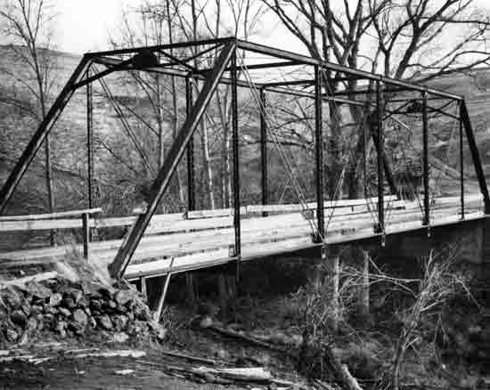
WILLOW CREEK (CECIL) BRIDGE The Willow Creek Bridge is a 60-foot steel pony truss, built by the Columbia Bridge Company of Portland. The pin connections and the rarity of the truss type, a half-hip Pratt, contribute to the significance of this bridge. The original 1909 name plaque is intact, and the roadway deck is of timber construction. The setting in the hilly rangeland of eastern Oregon is pleasant, and the unpaved country road is lightly traveled, adding to the historic feel of this early truss. Cecil, a small community which had a railroad station and post office, derived its name from the Cecil family, landowners in the area. The Oregon Trail crossed Willow Creek in the vicinity of the bridge. | ||
 | ||
| Structure Number 45C609 | Constructed - Ca. 1910 | |
| County Road 793 | Steel Through Truss (Pratt) | |
| Danner vicinity, Malheur County | Ownership - Malheur County | |
|
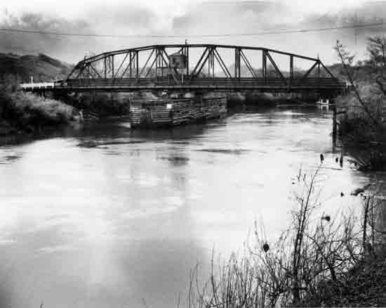
COW CREEK BRIDGE This 79-foot Pratt truss is pin-connected and typical of the metal trusses at the turn of the century. The Cow Creek Bridge achieves significance not only as a representative of pin-connected technology, but also due to its association with a significant early transportation route and nearby historic structures. A 1910 photo of the nearby Inskip Station shows the bridge in place. The bridge is on the Central Oregon Military Wagon Road (established in 1867) which became part of the Idaho-Oregon-Nevada (I.O.N.) Highway around 1881. | ||
 | ||
| Structure Number 32C362 | Constructed - 1910 | |
| County Road | Steel Through Truss (Pennsylvania-Petit) | |
| Troy, Wallowa County | Ownership - Wallowa County | |
|
GRANDE RONDE RIVER (TROY) BRIDGE The Troy Bridge stands among Oregon's early truss bridges as one of the most attractive and well-preserved examples of pin-connected technology. The main span of the Troy Bridge is a 175-foot long, pin-connected, steel truss of Pennsylvania-Petit configuration. A 60-foot steel Warren pony truss serves as a secondary span. Name plaques and portal messages list several local officials, the construction date, and the bridge builder, the Columbia Bridge Company of Walla Walla. | ||
 | ||
| Structure Number 59C534 | Constructed - Ca. 1910 (Site-1935) | |
| County Road 697 | Steel Pony Truss (Queenpost) | |
| Umapine vicinity, Umatilla County | Ownership - Umatilla County | |
|
PINE CREEK BRIDGE Though no nameplate is present on this structure and historic information is sketchy, the use of pin-connected technology establishes the construction date at about 1910. Records indicate the bridge was moved to its current location about 1935, where it serves a lightly traveled county road in the farmland of northeast Oregon. The roadway deck of the 51-foot steel pony truss is timber. The Pine Creek Bridge is important both for its pin connections and its rare truss type. This queenpost truss is one of only four in Oregon. | ||
 | ||
| Structure Number 39C501 | Constructed - 1912 (Site-1956) | |
| Richardson County Road 1288 | Steel Through Truss (Double-Intersection Warren) | |
| Richardson, Lane County | Ownership - Lane County | |
|
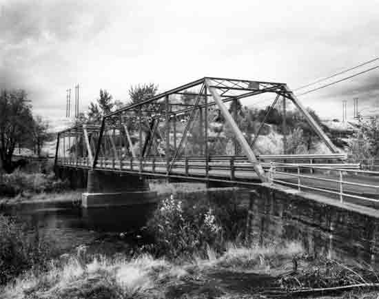
SIUSLAW RIVER (RICHARDSON) BRIDGE Built by the Coast Bridge Company in 1912, this structure is a 124-foot, double-intersection Warren, steel through truss. The Richardson Bridge is one of only two through trusses in Oregon with this truss type and is the oldest remaining through truss connected with rivets instead of pins. The other double-intersection Warren truss is the Crooked River (Elliott Lane) Bridge, Ca. 1914, in Crook County. (See Appendix E.) Originally located across the Crooked River near Prineville, the Richardson Bridge was moved to its current site in 1956. The bridge replaced an earlier nearby timber bridge. The community of Richardson was named for the pioneer family who settled in the area in 1889. Richardson family members still reside near the bridge. | ||
 | ||
| Structure Number 24T03 | Constructed - 1913 | |
| S.W. 10th Street | Steel Pony Truss (Warren with Polygonal Upper Chords) | |
| Pendleton, Umatilla County | Ownership - City of Pendleton | |
|
UMATILLA RIVER (S.W. 10TH STREET) BRIDGE This 311-foot structure consists of three steel pony trusses, Warren trusses with polygonal upper chords. It is one of Oregon's earliest highway trusses built using rivet connections and illustrates the concept of utilizing polygonal, rather than straight, top chords. This design reduces the dead load of the structure and the amount of materials needed. The bridge has a lattice steel railing. It is the longest of Oregon's pre-1941 pony trusses and the only one to utilize three pony spans in series. The S.W. 10th Street Bridge was historically known as the Star Street Bridge. The name of the street was changed in the 1940-50s period. The bridge drawings indicate it was built by the American Bridge Company of New York. This is the only known bridge in Oregon designed by that prolific company, started originally by Andrew Carnegie. This bridge was determined eligible for the National Register in April 1985. | ||
 | ||
| Structure Number 13757 | Constructed - 1914 | |
| Milton Way | Steel Pony Truss (Warren) | |
| St. Helens, Columbia County | Ownership - City of St. Helens | |
|
LOWER MILTON CREEK (McDONALD) BRIDGE This 85-foot, rivet-connected, steel pony truss is one of the early bridges designed and constructed by the newly formed (1913) Oregon State Highway Department. The name "Henry L. Bowlby," Oregon's first state highway engineer, and the date "1914" appear on the name plaque, as well as the bridge number "11." The bridge was designed by C.H. Purcell, the first state bridge engineer. The truss type is a Warren, a relatively common type. The roadway deck is steel grating, which replaced the original creosoted timber deck in the 1930s. The structure was built by the Ambrose-Burdsall Company and completed in December 1914. A similar truss was also built in 1914 across Upper Milton Creek. The Lower Milton Creek Bridge served originally on the Pittsburg-St. Helens Highway. | ||
 | ||
| Structure Number 799 | Constructed - 1922 | |
| Wallowa Lake Highway 10, M.P. 16.43 (Bypassed) | Steel Deck Truss (Warren with Verticals) | |
| Elgin vicinity, Union County | Ownership - State of Oregon | |
|
GRANDE RONDE RIVER (OLD RHINEHART) BRIDGE The Old Rhinehart Bridge is a 320-foot structure, with a 142-foot main span containing a steel deck truss, Warren with verticals. The structure has been bypassed and abandoned. The remote setting and abandoned condition emphasize the historic feeling of the old bridge. The Old Rhinehart Bridge was constructed under the auspices of Conde B. McCullough, Oregon's noted state bridge engineer, and is a fine example of early steel deck truss construction in Oregon. The ornamental railing, support piers, brackets, and girder members are all essentially standard designs of the period. | ||
 | ||
| Structure Number 19B01 | Constructed - 1925 | |
| First Street | Timber Through Truss (Howe) Covered Bridge | |
| Drain, Douglas County | Ownership - City of Drain | |
|
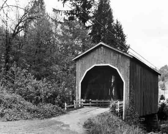
PASS CREEK BRIDGE The Pass Creek Bridge at Drain is a 61-foot housed Howe truss. The structure is one of the few Oregon covered bridges within city boundaries and is only two blocks from the Drain city center. The City of Drain owns the bridge. The covered bridge parallels a 1906 steel truss railroad bridge. Though the structure has been closed to traffic for many years, children still use the bridge on their way to and from a nearby school. The structure is relatively void of architectural detailing and has no openings for light except the portals. A marker indicates the original 1870s bridge at this site served as part of the overland stage route from Roseburg to Scottsburg. The bridge was determined eligible for the National Register in February 1985. | ||
 | ||
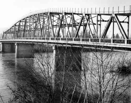
| Structure Number 1025D | Constructed - 1925 | |
| Albany-Corvallis Highway 31, M.P. 10.44 | Steel Through Truss (Parker) | |
| Albany-North Albany, Linn-Benton counties | Ownership - State of Oregon | |
|
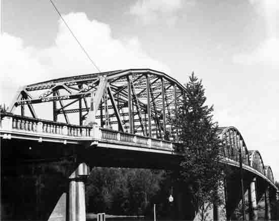
WILLAMETTE RIVER (ALBANY) BRIDGE An ornate railing and entrance pylons adorn this 1,090-foot structure over the Willamette River at Albany. The main spans of the bridge are four 200-foot steel Parker trusses. The bridge was designed by the state bridge engineer Conde B. McCullough and was constructed by the Union Bridge Company of Portland. The Albany Bridge is one of only a few remaining multiple truss spans in Oregon. This structure replaced an 1887 bridge across the Willamette River. | ||
 | ||
| Structure Unnumbered | Constructed - 1926 | |
| Bridge of the Gods Road | Steel Through Truss (Cantilever) | |
| Cascade Locks, Hood River County (Oregon) and Stevenson vicinity, Skamania County (Washington) | Ownership - Port of Cascade Locks | |
|
COLUMBIA RIVER (BRIDGE OF THE GODS) The Bridge of the Gods is a 1,856-foot long structure. The 1,131-foot steel cantilever through truss has a main span of 706 feet. Built by the Wauna Toll Bridge Company of Walla Walla, the original bridge was 1,127 feet long. When the Bonneville Dam was constructed, the structure was raised and lengthened to accommodate the rising water level. The bridge is significant not only as a fine example of cantilever technology and as a major crossing of the Columbia River, but also because of its location in the Columbia River Gorge. The bridge takes its name from an Indian myth describing a large natural rock bridge over the Columbia River at this site. The Bridge of the Gods is the third oldest highway bridge spanning the Columbia River along the Oregon-Washington border. | ||
 | ||
| Structure Number 5054 | Constructed - 1926 | |
| Mt. Hood Highway 26, M.P. 0.77 | Steel Deck Truss (Cantilever) | |
| Portland, Multnomah County | Ownership - State of Oregon | |
|
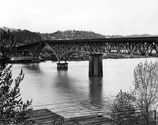
WILLAMETTE RIVER (ROSS ISLAND) BRIDGE The Ross Island Bridge is the only cantilever deck truss in Oregon. The structure appears to be a steel deck arch though it functions structurally as a cantilever truss. It was designed by internationally recognized consulting engineer Gustav Lindenthal. The main span was constructed by Booth and Pomeroy, while the approaches were contracted to Lindstrom and Feigenson. The 1,819-foot long cantilever truss contains a 535-foot main span. Including the twenty-nine approach spans, the length of the total structure is over 3,700 feet. In addition to its unique structural design, the spindle-type balustrade railing contributes to the appeal of this bridge. The Ross Island Bridge is one of ten highway bridges across the Willamette River in Portland and is the most southerly one in the central business district. It is one of three Willamete River bridges built by Multnomah County in the mid-1920s (Sellwood, 1925, and Burnside, 1926). | ||
 | ||
| Structure Number 1356 | Constructed - 1928 | |
| Cascadia State Park Road | Timber Deck Truss (Howe) | |
| Santiam Highway 16, M.P. 41.41 | Ownership - State of Oregon Cascadia, Linn County | |
|
SANTIAM RIVER (CASCADIA PARK) BRIDGE This structure is the only timber deck truss remaining on Oregon's highway system. The bridge is a 120-foot Howe truss span and is the only known Howe truss in Oregon that is not housed or covered. The roadway partially protects the truss from the elements. Though the steel vertical tension members are original, the timber portions of the truss have been replaced. The bridge plans are signed by Conde B. McCullough, State Bridge Engineer. The bridge was designed for Linn County by the State Highway Department, but was constructed by county forces. The bridge is located at the entrance to Cascadia State Park and is now state owned. | ||
 | ||
| Structure Number 1223 | Constructed - 1929 | |
| McKenzie Highway 15, M.P. 1.33 | Steel Through Truss (Warren with Polygonal Upper Chords) | |
| Springfield, Lane County | Ownership - State of Oregon | |
|
WILLAMETTE RIVER (SPRINGFIELD) BRIDGE The Springfield Bridge is a 1,090-foot structure, with a 550-foot steel continuous through truss main span. The bridge was designed by Conde B. McCullough, evidenced by the ornate entrance pylons and decorative concrete railing. (McCullough-designed structures usually exhibit a variety of architectural treatments, a popular nationwide style in the 1920-30s.) The Springfield Bridge is one of very few truss bridges to receive such artistic treatment. In addition, it is the largest non-cantilever truss span in the state and one of only three pre-1941 continuous truss designs. | ||
 | ||
| Structure Number 1893 | Constructed - 1933 | |
| County Road 10A | Timber Through Truss (Howe) Covered Bridge | |
| Sutherlin, Douglas County | Ownership - Douglas County | |
|
CALAPOOYA CREEK (ROCHESTER) BRIDGE This 80-foot housed Howe truss span was built by veteran Oregon covered bridge builder Floyd C. Frear. The Rochester Bridge is an important representative of covered bridge design and is well suited to its rural setting. The design of this bridge is unique among Oregon's housed structures, featuring side windows having graceful curved tops. There are four openings on either side. The portals have flat arched openings. The exposed false beams at the gable ends add architectural interest as well. | ||
 | ||
| Structure Number 1823 | Constructed - 1936 | |
| Oregon Coast Highway 9, M.P. 234.03 | Steel Through Truss (Cantilever) | |
| North Bend, Coos County | Ownership - State of Oregon | |
|
COOS BAY (McCULLOUGH MEMORIAL) BRIDGE Dedicated posthumously in 1947 to its designer, Conde B. McCullough, this cantilever truss exhibits an array of architectural and decorative features. In addition to its distinction as one of the most impressive of Oregon's bridges, it was the longest structure on Oregon's highway system when constructed, 5,305 feet. The 1,709 foot through truss has a main span of 793 feet and is flanked by thirteen open-spandrel, rib-type reinforced concrete deck arches. To ease design conflict between the steel truss and the arch spans, the cantilever was constructed with curved upper and lower chords. David Plowden in Bridges: The Spans of North America (1974) states, "Few later bridges of its type have been as outstanding." This bridge was the largest of five bridges constructed as part of the federally-assisted Oregon Coast Bridges project that replaced ferry service on major Oregon rivers and estuaries and essentially completed the Oregon Coast Highway (U.S. 101). | ||
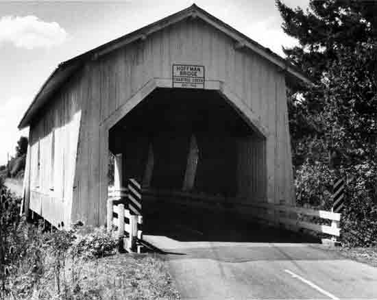 | ||
| Structure Number 1724 | Constructed - 1936 | |
| Hungry Hill Drive County Road 647 | Timber Through Truss (Howe) Covered Bridge | |
| Crabtree vicinity, Linn County | Ownership - Linn County | |
|
CRAB TREE CREEK (HOFFMAN) BRIDGE The Hoffman Bridge, a 90-foot housed Howe truss, was built by Lee Hoffman in 1936 following State Highway Department standardized plans. To build this structure, trees were cut on nearby Hungry Hill and hauled by horses to the construction site. The structure is an attractive and well-crafted example of the covered bridge tradition in Oregon. The bridge has small gothic-style windows. It is located in a rural environment near Crabtree, settled in 1845. The portal design, originally rounded when the bridge was constructed, was enlarged and squared to permit larger loads. | ||
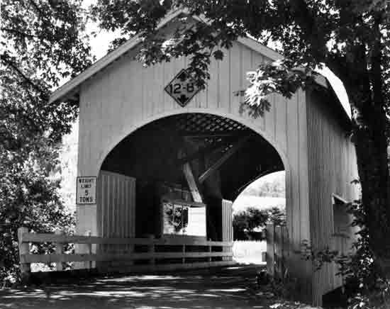 | ||
| Structure Number 10C220 | Constructed - 1939 | |
| Neal Lane County Road 124 | Timber Through Truss (Kingpost) Covered Bridge | |
| Myrtle Creek vicinity, Douglas County | Ownership - Douglas County | |
|
SOUTH MYRTLE CREEK (NEAL LANE) BRIDGE One of the shortest covered bridges in Oregon at 42 feet, the Neal Lane Bridge is the only covered bridge with a kingpost truss in the state. The plank flooring, arched portals, narrow window openings, and rural setting add to the appeal of this bridge. The Neal Lane Bridge, built for only $1,000, was constructed by Douglas County in 1939. Floyd C. Frear was the county engineer, with Homer Gallop, the bridge foreman. | ||
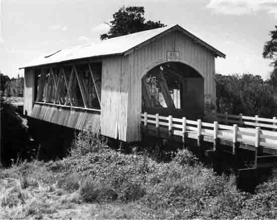 | ||
| Structure Number 12943 | Constructed - 1939 | |
| Goar County Road 629 | Timber Through Truss (Howe) Covered Bridge | |
| Scio vicinity, Linn County | Ownership - Linn County | |
|
THOMAS CREEK (GILKEY) BRIDGE This distinctive representative of Oregon's covered bridge heritage takes its name from the community of Gilkey. The community, established in 1880, was a center for shipment of farm products, but has since virtually disappeared leaving only the covered bridge as a reminder of its existence. The structure is a 120-foot housed Howe truss. The large side openings are distinctive of seven similar covered bridges in Linn County. Until 1960, a covered railroad bridge stood adjacent to the Gilkey Bridge. | ||
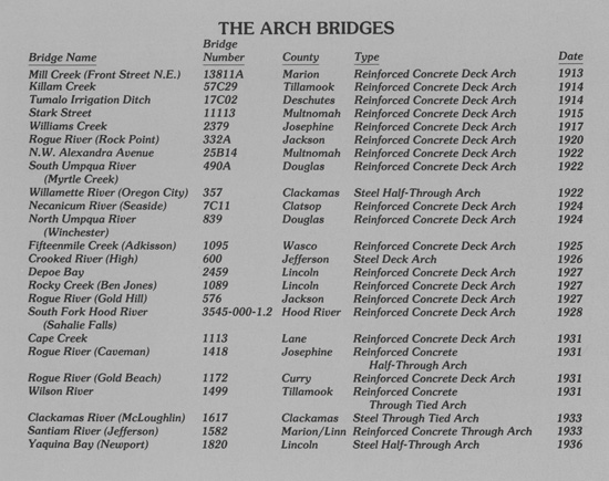
ARCH BRIDGES
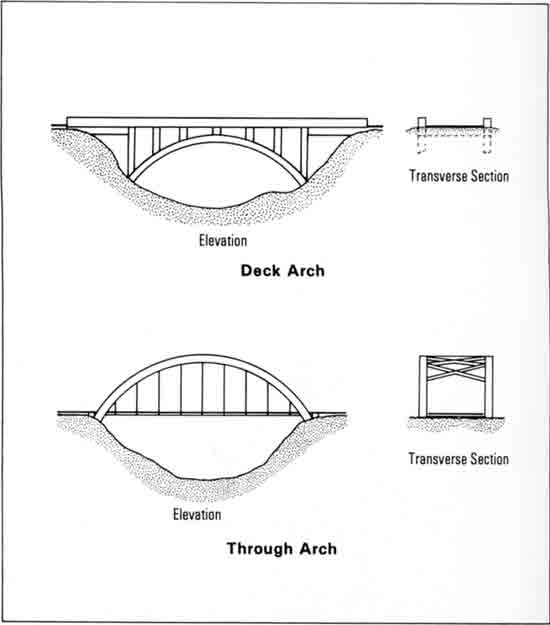
An arch bridge is a bridge type in which convexly curved structural members span an opening and provide support for the roadway. Load stresses are transferred to piers or abutments through direct compression of the structural members. Arch bridges are usually of two basic forms, a deck arch and a through arch. Half-through arches, however, are also present with the roadway crossing through the middle of the arch. Deck arches are either open or filled spandrel in design, the spandrel being the area above the arch and below the roadway.
Arch bridges are particularly adapted to architectural treatment, as demonstrated superbly in Oregon's highly detailed arch structures. Unlike the other bridge types, arch structures are typically ornate. It is the arch bridges which seem to generate recognition and local pride. Where the truss can evoke nostalgia from the engineer, it is invariably the arch structures which seem able to stimulate such feelings in the remainder of the community.
Oregon currently has 64 arch bridges on its highway system. Fifty-three of these structures were built prior to 1941, with some dating back to about 1910. Many of the earliest arches have been structurally modified and no longer retain their original integrity.
The arch bridges designed by Conde B. McCullough comprise a special class of bridges in Oregon. Oregon's noted state bridge engineer created innovative and artistic structures, many of which have gained national attention. In his long career with the State Highway Department, he is credited with designing and constructing 34 major arch structures.* Only two of his arch bridges have been replaced: the Keno Bridge (1931), a three-span through reinforced concrete structure across the Klamath River in Klamath County; and the Eagle Creek Bridge, a three-span steel tied arch (1936) on the Columbia River Highway in Multnomah County. One span of the Eagle Creek bridge was saved and is now the Clackamas River (Barton) Bridge (1970), Clackamas County.
|
Many of McCullough's arch bridges have been modified over the years, and several others have now reached the end of their useful service and are scheduled for replacement. This document includes views and descriptions of 32 McCullough arches, including 19 study identified arch bridges. Four other McCullough arch bridges have previously been listed on the National Register or determined eligible and are shown in the Old Columbia River Highway Bridges and Other Historic Bridges sections of this document. Nine of his arch structures are in the Reserve Bridges section (Appendix E).
Twenty-four arch bridges (including both McCullough and non-McCullough designs) were identified as historically significant structures and are presented on the following pages.
*Several McCullough bridges consist of non-arch mainspans, but have arched secondary spans. These bridges are included in the arch bridges count above, but are located in the document under the main span type in the Study Identified Bridges section. They include the Coos Bay (McCullough Memorial) Bridge—steel cantilever truss, the Siuslaw River (Florence) Bridge—steel bascule span, and the Umpqua River (Reedsport) Bridge—steel swing span.
|
 | ||
| Structure Number 13811A | Constructed - 1913 | |
| Front Street, N.E. | Reinforced Concrete Deck Arch | |
| Salem, Marion County | Ownership - City of Salem | |
|
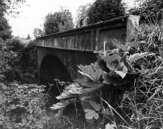
MILL CREEK (FRONT STREET, N.E.) BRIDGE This 40-foot filled spandrel concrete barrel arch is the oldest unaltered arch structure on Oregon's highway system. The bridge was originally a railroad bridge built for the Oregon Electric Railway by Hurley-Mason and Company and designed by A. M. Lupfer of the Spokane, Portland, and Seattle Railway. The date of construction, 1913, is shown at the top of the arch. The structure functions as a railroad bridge, but also provides automobile and truck traffic service. | ||
 | ||
| Structure Number 57C29 | Constructed - 1914 | |
| South Prairie County Road 765 | Reinforced Concrete Deck Arch | |
| Tillamook vicinity, Tillamook County | Ownership - Tillamook County | |
|
KILLAM CREEK BRIDGE The Killam Creek Bridge is a 52-foot multi-radius concrete deck arch designed by U.G. Jackson, the county surveyor for Tillamook County. The structure is one of the oldest extant arch bridges in the state and is a typical example of the early applications of reinforced concrete to short-span highway bridges. The bridge has little architectural or decorative treatment. The low railings are filled concrete with some fluting, and two of the four original railing end posts are missing. The names of county officials from the period are listed on the bridge railings. The structure was built by local contractor, C. F. Feldschau, for $2,500. The Killam Creek Bridge was on the Oregon Coast Highway prior to the relocation of the highway to a new alignment in the late 1940s. | ||
 | ||
| Structure Number 17C02 | Constructed - 1914 | |
| Seisemore County Road | Reinforced Concrete Deck Arch | |
| Tumalo vicinity, Deschutes County | Ownership - Deschutes County | |
|
TUMALO IRRIGATION DITCH BRIDGE The Tumalo Irrigation Ditch Bridge (historically, Bull Creek Dam Bridge) was constructed as part of the ill-fated Tumalo Irrigation Project (1902-15). The Tumalo Bridge is notable for its role in this state reclamation project and for its unique design. The bridge consists of five continuous filled-spandrel, barrel-type, concrete deck arch spans, each 25 feet long. The concrete piers are keyed into notches in the arch structure. Four panels on the spandrel walls read, "State of Oregon 1914." The bridge, dam and spillway were designed by Olaf Laurgaard, who later became city engineer for Portland. The Bull Creek Dam under the bridge and the nearby Tumalo Dam were constructed to form a water storage reservoir to increase the amount of irrigated acreage at Tumalo. The Bend-to-Sisters road was rerouted around the eastern perimeter of the reservoir, crossing both dams. (This is the present-day, unpaved Seisemore Road.) When water was turned into the basin after dam construction, it failed to hold the storage water. The water escaped through rock fissures underlying the volcanic surface rock on the reservoir floor. | ||
 | ||
| Structure Number 11113 | Constructed - 1915 | |
| Stark Street | Reinforced Concrete Deck Arch | |
| Gresham vicinity, Multnomah County | Ownership - Multnomah County | |
|
STARK STREET VIADUCT This structure is a 68-foot filled spandrel, rib-type, reinforced concrete deck arch. The structure spans a small drainage that flows into the nearby Sandy River. On the Sandy River side of the bridge is an ornate overlook area with benches. Architectural treatment of the viaduct includes solid concrete railing with panels, stone masonry approach railing, and two ornamental lampposts. The lampposts are adorned with Ionic order column caps and pine cone replicas. The lamps are no longer present. The Stark Street Viaduct achieves its main distinction through this ornate treatment and its relationship to the original Columbia River Highway. The structure was built at the same period as the Columbia River Highway in the Columbia Gorge and has design elements similar to the structures on that highway. Stark Street served as one of the main routes connecting Portland with the scenic Columbia River Highway. | ||
 | ||
| Structure Number 2379 | Constructed - 1917 | |
| Jacksonville Highway 272, M.P. 13.12 | Reinforced Concrete Deck Arch | |
| Provolt vicinity, Josephine County | Ownership - State of Oregon | |
|
WILLIAMS CREEK BRIDGE The Williams Creek Bridge is an 80-foot filled-spandrel, rib-type, concrete deck arch with a low rise. The bridge railings are a simple frame design and appear to be a later addition. The structure has a unique feature, the roadway rises to follow the shape of the arch. The bridge was constructed by Albert Anderson, a local contractor for Josephine County, and was acquired by the state in 1933. | ||
 | ||
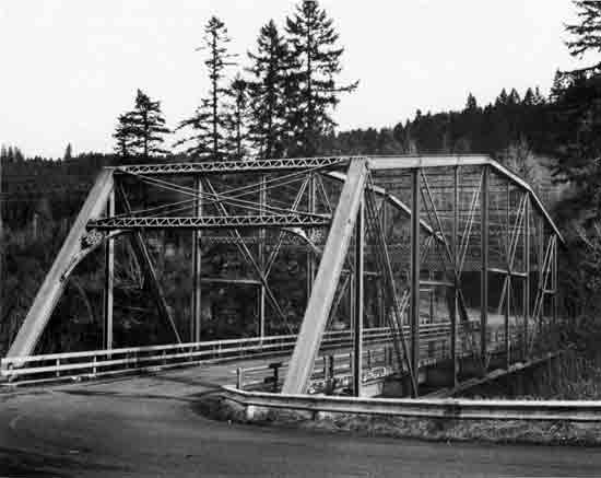
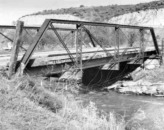
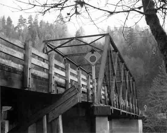
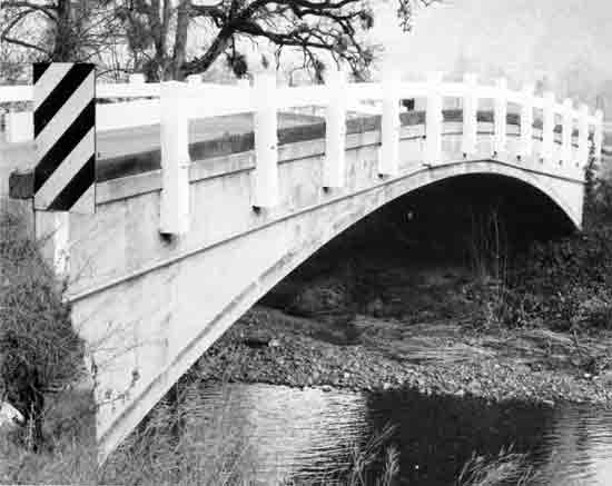
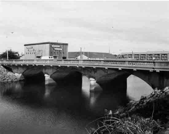
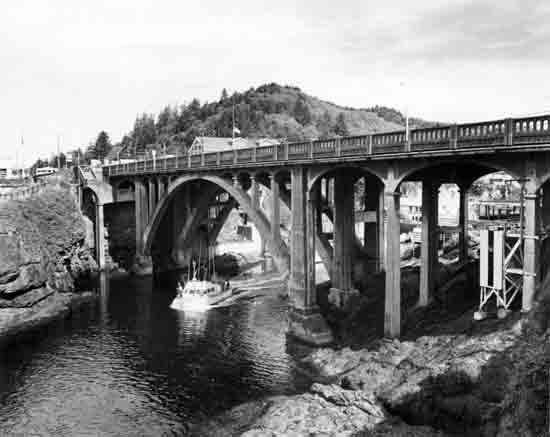
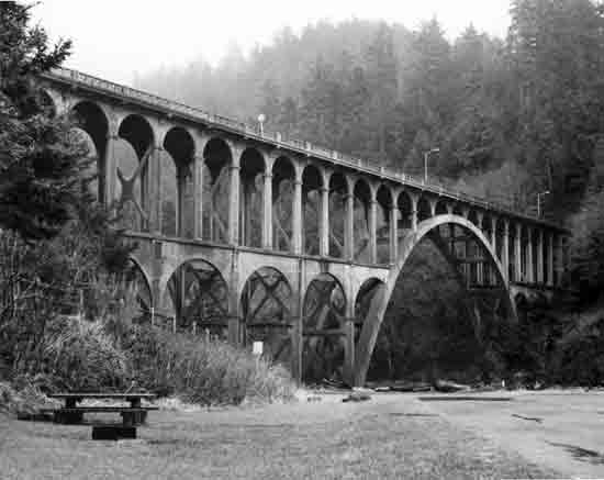
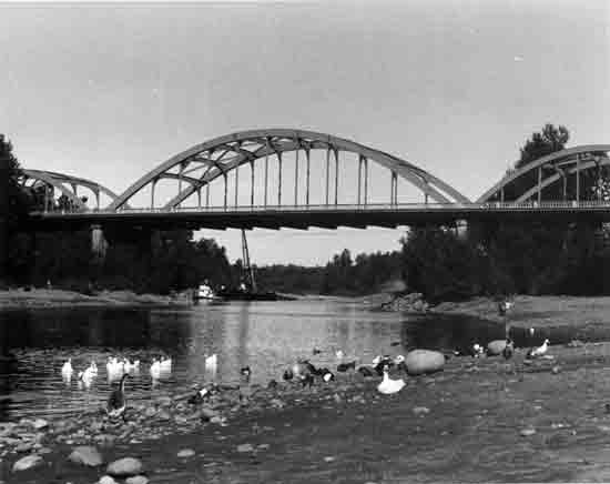
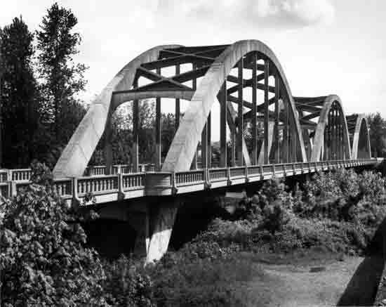
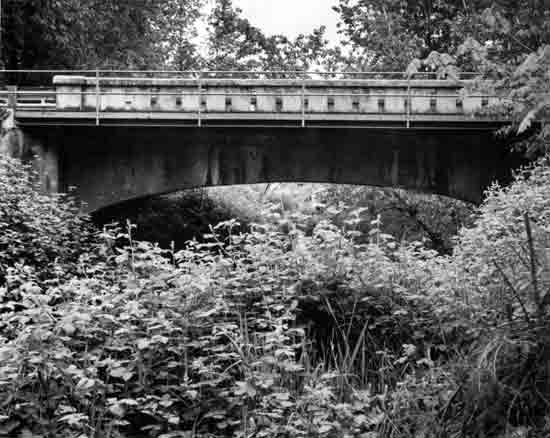
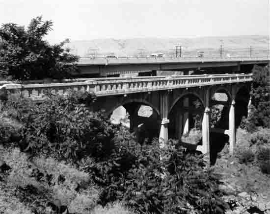
| Structure Number 332A | Constructed - 1920 | |
| Sam's Valley Highway 271, M.P. 0.09 | Reinforced Concrete Deck Arch | |
| Gold Hill vicinity, Jackson County | Ownership - State of Oregon | |
|
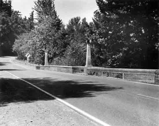
ROGUE RIVER (ROCK POINT) BRIDGE This structure is an early major arch bridge completed under the design auspices of Conde B. McCullough, Oregon's noted bridge engineer. McCullough designed the Rock Point Bridge, originally on the old Pacific Highway, to conform with and complement the local landscape. The structure is 505 feet in length, and the main span is a single 113-foot open-spandrel, rib-type reinforced concrete deck arch. The structure has curved arch fascia curtain walls. The railing on the original main span is an urn-shaped balustrade with a band of dentils below. The ends of the main piers are bushhammered for textured contrast. This structure replaced a timber Howe truss covered bridge. The bridge was constructed by Parker and Banfield, Portland. Because of the great depth of the water at the bridge location, it was impossible to build falsework under the main arch span. The contractor solved the problem by building a temporary wood truss span over the river to give support to the forms. | ||
 | ||
| Structure Number 25B14 | Constructed - 1922 | |
| N.W. Alexandra Avenue | Reinforced Concrete Deck Arch | |
| Portland, Multnomah County | Ownership - City of Portland | |
|
N.W. ALEXANDRA AVENUE VIADUCT Designed by Fred T. Fowler under the direction of Portland City Engineer Olaf Laurgaard, this 150-foot rib-type reinforced concrete deck arch is an important example of braced-spandrel construction in the tradition of the Latourell Creek Bridge (1914) on the Columbia River Highway. The arch ribs are not a continuous structure, but consist of ten separate chord members arranged in an arch form. Concrete trestle and beam approach spans are located at each end of the arch. The steel bar handrails replaced an original concrete precast panel railing. The culmination of Fred Fowler's bridge design career with the City of Portland was the S. W. Vista Avenue Viaduct, completed in 1926. (See Other Historic Bridges group.) | ||
 | ||
| Structure Number 490A | Constructed - 1922 | |
| Myrtle Creek Highway 237, M.P. 0.40 | Reinforced Concrete Deck Arch | |
| Myrtle Creek, Douglas County | Ownership - State of Oregon | |
|
SOUTH UMPQUA RIVER (MYRTLE CREEK) BRIDGE Six reinforced concrete deck girder spans and three open-spandrel rib-type concrete deck arch spans make up this 547-foot structure designed by Conde B. McCullough. As McCullough's first multi-span arch, the Myrtle Creek Bridge represents a design theme to which McCullough returned many times in his career. Typical of his attention to architectural details, McCullough provided this structure with arched fascia curtain walls, bracketing, and decorative sidewalk railing. This bridge replaced a four-span timber Howe truss bridge. The arch bridge was built on the old Pacific Highway by Lindstrom and Feigenson, Portland. | ||
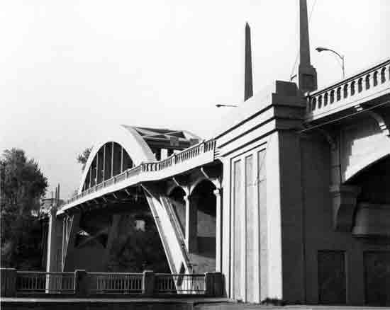 | ||
| Structure Number 357 | Constructed - 1922 | |
| Oswego Highway 3, M.P. 11.43 | Steel Half-Through Arch | |
| Oregon City-West Linn, Clackamas County | Ownership - State of Oregon | |
|
WILLAMETTE RIVER (OREGON CITY) BRIDGE The Willamette River Bridge at Oregon City is a 745-foot structure consisting of a 360-foot steel through arch and eleven concrete deck girder approach spans. The steel arch span is protected from corrosion by encasement in sprayed-on concrete (Gunite), which gives it the appearance of a concrete structure. The detailing—pylons, ornate bridge railing, arched fascia curtain walls, fluted Art-Deco main piers, and the use of bush-hammered inset panels—identify this structure as a Conde B. McCullough design and contributes to the significance of the structure. The Oregon City Bridge is one of only four half-through arch designs in the state. The bridge replaced a suspension span built at this site in 1888. The suspension cables were used to support the arch sections during construction of the current bridge. The bridge was built by A. Guthrie and Company, Portland, and was originally on the old Pacific Highway. | ||
 | ||
| Structure Number 7C11 | Constructed - 1924 | |
| West Broadway Street | Reinforced Concrete Deck Arch | |
| Seaside, Clatsop County | Ownership - City of Seaside | |
|
NECANICUM RIVER (SEASIDE) BRIDGE This structure is the only known patented Luten arch in Oregon. The design and construction methods devised by Daniel B. Luten, a consulting engineer from Indianapolis, were widely used nationwide between 1910 and 1930. This ornate concrete deck arch consists of three 41-foot filled-spandrel, barrel-type sections with integral approaches. The bridge contains decorative urn-shaped balustrade railings and lampposts. A southside monument pedestal contains a bronze bas-relief, "Old Oregon Trail," by noted Oregon sculptor Avard Fairbanks. (The companion north pedestal relief is missing.) | ||
 | ||
| Structure Number 839 | Constructed - 1924 | |
| Oakland-Shady Highway 234, M.P. 12.21 | Reinforced Concrete Deck Arch | |
| Winchester, Douglas County | Ownership - State of Oregon | |
|
NORTH UMPQUA RIVER (WINCHESTER) BRIDGE Another of Conde B. McCullough's major arch bridges, the Winchester Bridge is a remarkable 884-foot structure consisting of seven 112-foot open spandrel, rib-type reinforced concrete deck arch spans and five concrete deck girder approach spans. A gothic arch motif is evident in the spandrel fascia curtain walls, the railing balustrade, and in the recessed panels above the end piers. Curved, decorative bracketing, observation balconies and a band of dentils add to the architectural interest of the structure. The bridge was dedicated to Robert A. Booth, one of the early State Highway Commission members. The structure replaced a three-span steel through truss bridge. The bridge was originally on the old Pacific Highway and was constructed by H. E. Doering, Portland. | ||
 | ||
| Structure Number 1095 | Constructed - 1925 | |
| Boyd County Road | Reinforced Concrete Deck Arch | |
| Boyd vicinity, Wasco County | Ownership - Wasco County | |
|
FIFTEENMILE CREEK (ADKISSON) BRIDGE The Fifteenmile Creek Bridge was designed by State Highway Bridge Engineer Conde B. McCullough, and built by George F. Reeves of Portland. A photograph of the original nameplate on the bridge identified the structure as the Adkisson Bridge. The structure, designed for Wasco County, is a single span reinforced concrete deck arch 148 feet in length. The main span is 120-feet long. Like many open-spandrel McCullough spans, the spandrel columns display curved arched fascia curtain walls, precast concrete railings with small arched openings, capped posts, ornate brackets supporting the railing, and a band of dentils below the railing. The tasteful architectural treatment of the structure and its exceptional pastoral setting contribute to the significance of this bridge. | ||
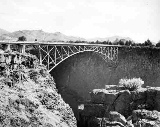 | ||
| Structure Number 600 | Constructed - 1926 | |
| The Dalles-California Highway 4, M.P. 141.68 | Steel Deck Arch | |
| Terrebonne vicinity, Jefferson County | Ownership - State of Oregon | |
|
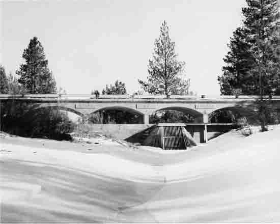
CROOKED RIVER (HIGH) BRIDGE This highway span over the Crooked River Gorge provides one of the leading points of scenic grandeur in the central portion of the state. Designed by Conde B. McCullough, this bridge is 464 feet long and consists of a 330-foot two-hinged steel braced-spandrel deck arch. The structure was one of the highest bridges in the United States (at 295 feet from deck to stream bed) when it was constructed. Architectural features include an ornamental concrete bridge railing and entrance pylons. A high line cableway was used in the erection of the structure. It is located just upstream from the 1911 Oregon Trunk Railroad steel arch bridge designed by Ralph Modjeski. | ||
 | ||
| Structure Number 2459 | Constructed - 1927 | |
| Oregon Coast Highway 9, M.P. 127.61 | Reinforced Concrete Deck Arch | |
| Depoe Bay, Lincoln County | Ownership - State of Oregon | |
|
DEPOE BAY BRIDGE The Kuckenberg-Wittman Company of Portland built this single span reinforced concrete deck arch at the mouth of Depoe Bay in 1927. Designed by Conde B. McCullough, the structure maintains the beauty of the coastline and conforms with its environment. The Depoe Bay Bridge is an important example of McCullough's engineering and artistic treatment and a familiar Oregon Coast landmark. A stairwell on the bay side and a walkway at the north end of the bridge provide access to Depoe Bay State Park. The bridge is 312 feet in length, and the main span is a 150-foot rib deck arch with an open spandrel. The rib arches are three-hinged with skewback sections, and the spandrel fascia curtain walls are curved. The capacity of the bridge was increased in 1940, when an addition was made on the seaward side of the bridge. | ||
 | ||
| Structure Number 1089 | Constructed - 1927 | |
| Otter Crest Loop Road | Reinforced Concrete Deck Arch | |
| Otter Crest vicinity, Lincoln County | Ownership - State of Oregon | |
|
ROCKY CREEK (BEN JONES) BRIDGE The Rocky Creek Bridge, constructed on the Oregon Coast Highway in 1927, is one of the most beautifully sited bridges in the state. The bridge spans a small gorge in a picturesque section of the Oregon Coast. It is now bypassed and provides only local service. This structure is also known as the Ben Jones Bridge and is named for the "Father of the Coast Highway." This span is 360 feet long with a 160-foot-long reinforced concrete rib deck main arch. The structure has ten reinforced deck girder approach spans, five on either side of the main span. The open spandrel arch and approach columns have semicircular fascia curtain walls. It was designed by Conde B. McCullough and built by H.E. Doering, Portland. | ||
 | ||
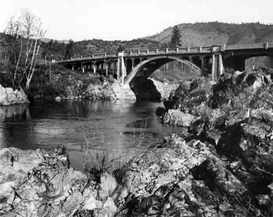
| Structure Number 576 | Constructed - 1927 | |
| Sam's Valley Highway 271, M.P. 2.65 | Reinforced Concrete Deck Arch | |
| Gold Hill, Jackson County | Ownership - State of Oregon | |
|
ROGUE RIVER (GOLD HILL) BRIDGE The Rogue River Bridge at Gold Hill was designed by Conde B. McCullough and is the only open spandrel barrel arch in the state. This particular design was chosen to provide high lateral strength for protection against high water. The main arch is 143 feet long and is constructed of reinforced concrete. The spandrel columns have semi-circular arched fascia curtain walls, and low arched curtain walls connect the approach columns, The O. N. Pierce Company of Portland built the structure, located on the old Pacific Highway. | ||
 | ||
| Structure Number 3545-000-1.2 | Constructed - 1928 | |
| Forest Road 3545 | Reinforced Concrete Deck Arch | |
| Mount Hood vicinity, Hood River County | Ownership - Mount Hood National Forest, United States Forest Service | |
|
SOUTH FORK HOOD RIVER (SAHALIE FALLS) BRIDGE The Sahalie Falls Bridge was designed and constructed by the United States Bureau of Public Roads, the antecedent of the present Federal Highway Administration. The main span is an 82-foot open-spandrel rib-type reinforced concrete deck arch. A pedestrian area with a stone masonry water fountain at the east end of the bridge provides a viewpoint of Sahalie Falls. The bridge is on a bypassed segment of the Mt. Hood Loop Highway near the Meadows Ski Area. | ||
 | ||
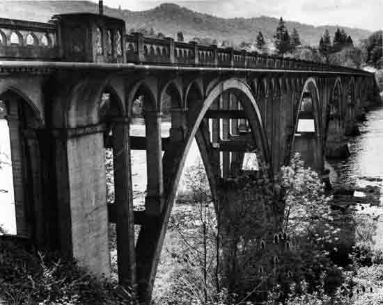
| Structure Number 1113 | Constructed - 1931 | |
| Oregon Coast Highway 9, M.P. 178.35 | Reinforced Concrete Deck Arch | |
| Heceta Head, Lane County | Ownership - State of Oregon | |
|
CAPE CREEK BRIDGE The bridge over Cape Creek, one of Conde B. McCullough's most unique and attractive arch designs, abuts the Cape Creek Tunnel on the Oregon Coast Highway at Devil's Elbow State Park. The numerous columns and arches of the bridge, complemented by the elevation, create an image reminiscent of the Roman viaducts, particularly the Pont du Gard, near Nimes, France. The double-tiered structure and the sheer number of arches promote a sense of rhythm that combines with the decorative bracketing and railing to make this a very handsome structure. The main span of the 619-foot structure is a 200-foot open-spandrel rib-type reinforced concrete deck arch. The Cape Creek Bridge was constructed by John K. Holt and the Clackamas Construction Company. | ||
 | ||
| Structure Number 1418 | Constructed - 1931 | |
| Redwood Highway 25, M.P. 0.14 | Reinforced Concrete Half-Through Arch | |
| Grants Pass, Josephine County | Ownership - State of Oregon | |
|
ROGUE RIVER (CAVEMAN) BRIDGE Three 150-foot reinforced concrete half-through arch spans and two 50-foot concrete deck girder approach spans make up this 550-foot structure across the Rogue River in Grants Pass. The bridge is one of only four half-through arch bridges in the state. Designed by Conde B. McCullough, the bridge is detailed with an ornate bridge railing, pylon lampposts, bracketing, and segmenting of the arch ribs. This is the fourth bridge to be located at this site, beginning with a timber bridge in 1886. The Caveman Bridge was built by J. K. Holt, Salem, and was originally on the old Pacific Highway. The name Caveman results from Grants Pass's location at the gateway to the Oregon Caves National Monument. The caveman serves as the civic symbol for Grants Pass and was selected as the name for the structure. | ||
 | ||
| Structure Number 1172 | Constructed - 1931 | |
| Oregon Coast Highway 9, M.P. 327.64 | Reinforced Concrete Deck Arch | |
| Wedderburn-Gold Beach, Curry County | Ownership - State of Oregon | |
|
ROGUE RIVER (GOLD BEACH) BRIDGE Designated as a National Historic Civil Engineering Landmark by the American Society of Civil Engineers in 1982, this 1,898-foot structure was designed by Conde B. McCullough and dedicated to Isaac Lee Patterson, Oregon Governor from 1927 to 1929. One of the most notable bridges in the Pacific Northwest, the Gold Beach Bridge consists of seven 230-foot open-spandrel rib type reinforced concrete deck arch spans and eighteen concrete deck girder approach spans. Architectural and decorative features include fluted Art-Deco entrance pylons, dentils, ornate bracketing and sidewalk railing, fluted spandrel columns and detailed arched fascia curtain walls. When completed, the Rogue River bridge was the largest structure constructed by the State Highway Department. It was the first structure in America to be constructed with the Freyssinet method of decentering and stress control, named after the French inventor. The success of the bridge led to the wide use of prestressing techniques in concrete construction. Although completed in late 1931, the dedication of the bridge did not occur until May 28, 1932. | ||
 | ||
| Structure Number 1499 | Constructed - 1931 | |
| Oregon Coast Highway 9, M.P. 64.73 | Reinforced Concrete Through Tied Arch | |
| Tillamook vicinity, Tillamook County | Ownership - State of Oregon | |
|
WILSON RIVER BRIDGE This bridge by Conde B. McCullough was the first concrete tied-arch span constructed in America. The main span of this 180-foot structure is a 120-foot reinforced concrete through tied arch (or bow-string arch) of elliptical shape. The choice of the tied arch was dictated by the location, where the cost of making large foundations to sustain the thrust of conventional arches would have been prohibitive. Ornate curved bracketing and ornamental sidewalk railing add detail to the bridge. The structure was built by the Clackamas Construction Company and replaced a steel through truss span at this site. | ||
 | ||
| Structure Number 1617 | Constructed - 1933 | |
| Pacific Highway East 1E, M.P. 11.20 | Steel Through Tied Arch | |
| Gladstone, Clackamas County | Ownership - State of Oregon | |
|
CLACKAMAS RIVER (MCLOUGHLIN) BRIDGE Designed by Conde B. McCullough, this 720-foot, three-span steel through tied-arch structure was the recipient of the 1933 Annual Award of Merit from the American Institute of Steel Construction as the "Most Beautiful Steel Bridge, Class C." Decorative features of the bridge include an ornamental concrete bridge railing, gothic arch shaped openings in the main piers, and fluted, Art-Deco entrance pylons. The bridge was built by Lindstrom and Feigenson, Portland, in conjunction with the McLoughlin Boulevard project between Oregon City and Portland. The bridge was dedicated to the memory of Dr. John McLoughlin, a leading figure in the early development of the Pacific Northwest. | ||
 | ||
| Structure Number 1582 | Constructed - 1933 | |
| Jefferson Highway 164, M.P. 6.24 | Reinforced Concrete Through Arch | |
| Jefferson, Marion-Linn counties | Ownership - State of Oregon | |
|
SANTIAM RIVER (JEFFERSON) BRIDGE Dedicated to early Oregon pioneer Jacob Conser, who operated a ferry at this site, this 780-foot structure consists of three 200-foot reinforced concrete through arch spans and four concrete deck girder approach spans. The ornate bridge railings, soffit bracketing, and extensively fluted and decorated entrance obelisks add to the beauty of the bridge and define it as a Conde B. McCullough design. | ||
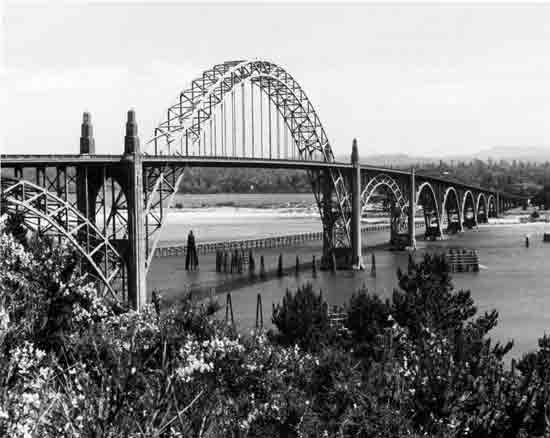 | ||
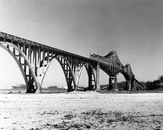
| Structure Number 1820 | Constructed - 1936 | |
| Oregon Coast Highway 9, M.P. 141.68 | Steel Half-Through Arch | |
| Newport, Lincoln County | Ownership - State of Oregon | |
|
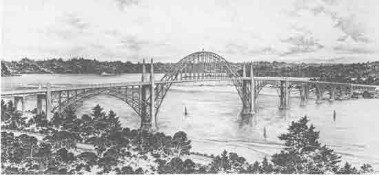
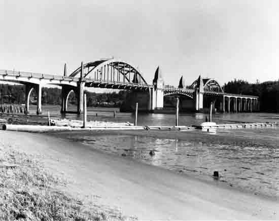
YAQUINA BAY (NEWPORT) BRIDGE The Yaquina Bay Bridge is an outstanding design and one of the most familiar and attractive bridges in Oregon. Constructed as one of five major bridges completed in 1936 under Oregon's Coast Bridges project, this Conde B. McCullough-designed structure is a combination of both steel and concrete arches. The main span of the 3,223-foot structure is a 600-foot steel through arch flanked by two 350-foot steel deck arches. There are five reinforced concrete deck arch secondary spans on the south end of the steel arches and fifteen concrete deck girder approach spans. Decorative elements include ornamental spandrel deck railing brackets, fluted entrance pylons, and a pedestrian plaza with elaborate stairways leading to observation areas. It was built by the Gilpin and General Construction companies and cost $1.3 million. | ||
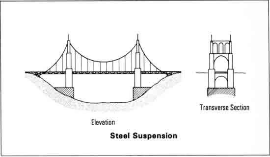
SUSPENSION BRIDGES
The suspension bridge is perhaps the most impressive of the bridge types. Usually large in size, with thin parabolic cables stretched between tall slender towers, the large suspension bridges in America are popular structural forms. They provide a fine, yet powerful, visual appearance and have become public monuments to bridge building. The Brooklyn Bridge and the Golden Gate Bridge, probably the best known bridges in America, are both suspension bridges.
|
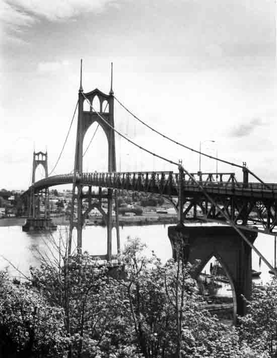
Large suspension highway structures are expensive and are usually most appropriate for long spans where conditions such as deep water prohibit closely-spaced piers. Only two public highway suspension bridges are known in Oregon, the St. John's Bridge (1931) across the Willamette River in Portland, Multnomah County (shown on the following page); and the Crooked River Bridge (1962) on Lake Billy Chinook in Jefferson County (Appendix F).
The St. John's Bridge is one of the most important bridges in the state because of its visual beauty, the fame of its designer, and the use of several technical innovations.
|
 | ||
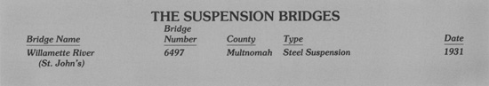
| Structure Number 6497 | Constructed - 1931 | |
| Northeast Portland Highway 123, M.P. 0.91 | Steel Suspension | |
| Portland, Multnomah County | Ownership - State of Oregon | |
|
WILLAMETTE RIVER (ST. JOHN'S) BRIDGE Designed by internationally-famous bridge engineer David B. Steinman, the St. John's Bridge is one of the most significant structures in the state and the only large early steel suspension bridge. The 1,207-foot main span was the longest of its type in the world for many years. Steinman utilized many innovative features in the bridge, such as the highest concrete rigid frame pier in the world, the first use of main steel towers (400 feet high) without conventional diagonal bracing, and the use of prestressed rope strands (spun by John A. Roebling's Sons Company, of Brooklyn Bridge fame) instead of the conventional parallel wire cable construction. The bridge was built by Multnomah County and later acquired by the state. It is the tallest of the bridges in Portland with a 205-foot navigational clearance at zero water level. When the St. John's Bridge opened, the last of the Willamette River ferries in Portland was retired, ending a method of river crossing that lasted 83 years. St. John's Bridge is a designated Portland Historical Landmark. | ||
MOVEABLE BRIDGE
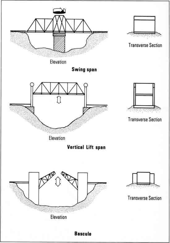
The moveable bridge is utilized where the roadway would otherwise obstruct a navigable waterway and impede river traffic. Due to the large number of navigable waterways in the state, the moveable span bridge has played an important role in the development of Oregon's transportation system.
The three major types of moveable bridges, illustrated at right, are the swing, vertical lift, and bascule. The swing span represents the oldest of these three basic moveable bridge types. Swing spans were slow to operate, however, and were displaced by more efficient and quicker opening bascule and vertical-lift bridges. No swing span bridges have been constructed in Oregon since 1939.
|
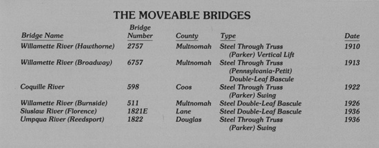
Twenty-eight moveable span bridges remain in Oregon, 18 of which were constructed before 1941. Two of Oregon's moveable span bridges, the Columbia River (Interstate Northbound) Bridge (1917) and the Steel Bridge (1912) across the Willamette River in Portland, are already listed or eligible for the National Register. Six additional moveable structures have been identified as historically significant and are shown on the following pages.
|
 | ||
| Structure Number 2757 | Constructed - 1910 | |
| Madison Street-Hawthorne Boulevard | Steel Through Truss (Parker) Vertical Lift | |
| Portland, Multnomah County | Ownership - Multnomah County | |
|
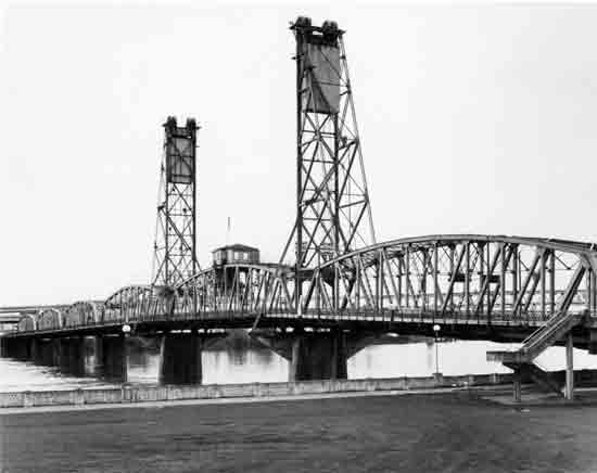
WILLAMETTE RIVER (HAWTHORNE) BRIDGE The Hawthorne Bridge is the oldest remaining highway structure across the Willamette River. The main span is a 244-foot steel through truss (Parker) vertical lift span, capable of a vertical movement of 110 feet and providing a lateral waterway clearance of 230 feet. Two electric motors lift the vertical deck lift span. The two towers are 165 feet tall. The bridge includes five steel through truss (Parker) secondary spans, each 220 feet in length, and thirteen concrete approach spans. The Hawthorne Bridge is the lowest of the Willamette River bridges in Portland, with 53 feet of clearance at low water, and consequently is raised more than any of the other drawbridges. This structure replaced a timber drawspan structure (Madison Street Bridge) built in 1891 and destroyed by fire in 1902. The Hawthorne Bridge has little architectural or decorative treatment. It was designed by Waddell and Harrington, Kansas City, and constructed by the Pennsylvania Steel Company, Portland, for a total cost of $511,000. | ||
 | ||
| Structure Number 6757 | Constructed - 1913 | |
| Broadway Street | Steel Through Truss (Pennsylvania-Petit) Double-Leaf Bascule | |
| Portland, Multnomah County | Ownership - Multnomah County | |
|
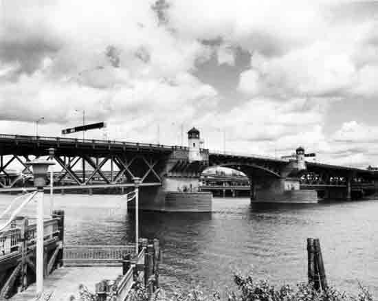
WILLAMETTE RIVER (BROADWAY) BRIDGE The Broadway Bridge, designed by the internationally famous bridge designer Ralph Modjeski, is cited as "an important example of the Rall-type bascule span" by David Plowden in Bridges: The Spans of North America (1974). The rarity and uniqueness of the Rall bascule structure add considerable technological interest to this structure. Built over a period of two years by the Pennsylvania Steel Company at a cost of $1.6 million, the bridge was the longest double-leaf bascule drawbridge in the world when constructed. The central span is a 297-foot steel through truss double-leaf bascule drawspan, providing 250 feet of lateral waterway clearance. The five secondary spans, four Pennsylvania-Petit steel through trusses and one Pratt steel through truss total 1,736 feet in length. An ornate vintage wrought iron bridge railing adjoins the sidewalks. | ||
 | ||
| Structure Number 598 | Constructed - 1922 | |
| Coquille-Bandon Highway 244, M.P. 17.08 | Steel Through Truss (Parker) Swing | |
| Coquille, Coos County | Ownership - State of Oregon | |
|
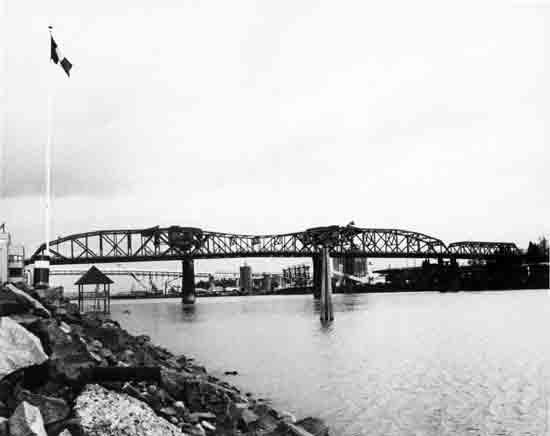
COQUILLE RIVER BRIDGE Designed under the auspices of Conde B. McCullough and constructed by local contractor A.B. Gidley, the Coquille River Bridge is a 255-foot steel through truss swing span. This structure is one of only six remaining swing spans on Oregon's highway system and is representative of this virtually obsolete moveable bridge type. (Four of Oregon's swing spans are in the final stages of bridge replacement planning.) The quicker and more efficient lifts and bascules have displaced the swing span system as the preferred moveable bridge types. The Coquille River Bridge is unique in its asymmetrical characteristics. Commonly referred to as a "bobtail" design, the swing span pivots on an off-center axis to obtain the maximum lateral waterway clearance. Once a busy commercial river site, the bridge is now rarely opened. A small riverside county park is near the structure. | ||
 | ||
| Structure Number 511 | Constructed - 1926 | |
| Burnside Street | Steel Double-Leaf Bascule | |
| Portland, Multnomah County | Ownership - Multnomah County | |
|
WILLAMETTE RIVER (BURNSIDE) BRIDGE The Burnside Bridge is a double-leaf bascule drawspan. It replaced the original 1894 wrought iron truss swing span structure. Two spans of the 1894 structure were moved to new locations and are the oldest highway bridges in Oregon (Bull Run River Bridge and the Sandy River Bridge on Lusted Road, both in Clackamas County). The Burnside Bridge has two 266-foot steel deck truss secondary spans and thirty-four steel deck girder approach spans for a total structure length of 2,308 feet. The bascule system for the bridge was designed by Joseph B. Strauss, who later designed San Francisco's Golden Gate Bridge. The principal engineer for the Burnside bridge was noted engineer Gustav Lindenthal. The original design concept is credited to I.G. Hendrick and Robert Kremers of Multnomah County, who were later replaced by Lindenthal. The Pacific Bridge Company constructed the bridge. Architectural treatment of the bridge includes an ornate spindle-type balustrade railing (wrought iron on the bascule section) and turreted operator shelters cantilevered from the massive main piers. The Burnside Bridge is distinguished as one of the most visually appealing of Portland's Willamette River bridges. | ||
 | ||
| Structure Number 1821E | Constructed - 1936 | |
| Oregon Coast Highway 9, M.P. 109.98 | Steel Double-Leaf Bascule | |
| Florence, Lane County | Ownership - State of Oregon | |
|
SIUSLAW RIVER (FLORENCE) BRIDGE This combination steel double-leaf bascule drawspan and reinforced concrete through tied arch structure is an outstanding example of the bridge engineering of Conde B. McCullough. Decorative treatment abounds with approach pylons, ornate railings, obelisk towers, and other details on the bridge. The Florence Bridge was one of five major structures built as part of Oregon's Coast Bridges project in 1936. Like the other bridges completed on the Oregon Coast Highway in 1936, the Florence Bridge replaced ferry service across one of Oregon's major rivers. The 140-foot central bascule drawspan is between two 154-foot concrete through tied (or bowstring) arch spans. Twenty concrete girder approach spans contribute to a total structure length of 1,568 feet. The bridge was built by the Mercer-Fraser Company, Eureka. | ||
 | ||
| Structure Number 1822 | Constructed - 1936 | |
| Oregon Coast Highway 9, M.P. 211.11 | Steel Through Truss (Parker) Swing | |
| Reedsport, Douglas County | Ownership - State of Oregon | |
|
UMPQUA RIVER (REEDSPORT) BRIDGE One of the five major structures built during Oregon's Coast Bridges project, the Umpqua River Bridge is an important example of Conde B. McCullough's bridge engineering accomplishments. The steel through truss central span, at 430 feet, is the largest swing span structure in Oregon and is notable as a representative of this outdated moveable bridge technology. Only five other swing span bridges remain on Oregon's highway system. Two 154-foot reinforced concrete through tied (or bowstring type) arch spans are on either side of the central truss swing span. Though not as ornate as some of McCullough's bridges, the Reedsport Bridge has decorative railings, bracketing, and approach pylons. The bridge was built by Teufel and Carlson, Seattle. | ||
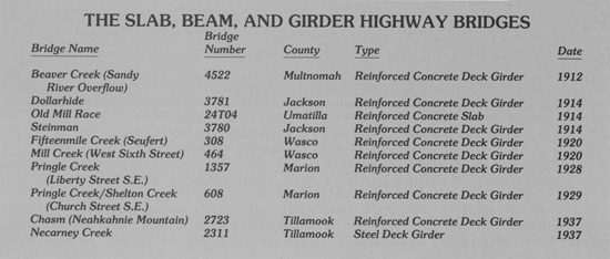
SLAB, BEAM, AND GIRDER BRIDGES
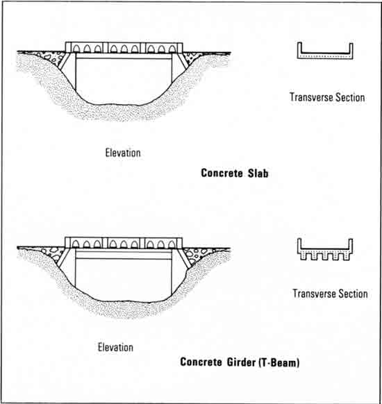
The majority of the early bridges in Oregon are of the slab, beam, and girder type. A slab bridge consists of a single piece of reinforced concrete or other material supported by piers or abutments. The roadway and its support are integral in the slab bridge form. The beam and girder bridges may be of timber, steel or reinforced concrete. The deck of a beam structure is supported by transverse structural members framed into the main outer longitudinal structural members. In a girder bridge, the deck is supported by one or more longitudinal structural members without the transverse members.
|
This bridge type has not received much historic attention because of the normally common design, the relative uniformity of appearance, and the large numbers. The ODOT study, nonetheless, identified ten outstanding historic bridges of this type.
|
 | ||
| Structure Number 4522 | Construction - 1912 | |
| Crown Point Highway 125, M.P. 1.74 | Reinforced Concrete Deck Girder | |
| Troutdale, Multnomah County | Ownership - State of Oregon | |
|
BEAVER CREEK (SANDY RIVER OVERFLOW) BRIDGE This 40-foot concrete deck girder bridge was built in 1912 and is Oregon's oldest unaltered concrete girder bridge. The bridge has arched outer girder members and a heavy concrete railing typical of the era. A metal pipe outer railing appears to be a later addition. The bridge was built by Multnomah County and served on the old Columbia River Highway. | ||
 | ||
| Structure Number 3781 | Constructed - 1914 | |
| Siskiyou Highway 273, M.P. 4.70 | Reinforced Concrete Deck Girder | |
| Steinman vicinity, Jackson County | Ownership - State of Oregon | |
|
DOLLARHIDE OVERCROSSING This 86-foot three-span concrete deck girder structure was built in 1914 for a cost of $5,900. A notable early example of the use of reinforced concrete in Oregon, it was constructed on the old Pacific Highway. The bridge's skewed design allows for both the crossing of the railroad and curvature of the roadway. Its heavy concrete railing was common during the 1910-1920 period. The structure was designed under the auspices of the state bridge engineer C.H. Purcell. J. W. Sweeney was the contractor. | ||
 | ||
| Structure Number 24T04 | Constructed - 1914 | |
| S.E. Court Place | Reinforced Concrete Slab | |
| Pendleton, Umatilla County | Ownership - City of Pendleton | |
|
OLD MILL RACE BRIDGE This 28-foot structure is the oldest known concrete slab structure on Oregon's highway system. Designed by Pendleton city engineer Geary Kimbrell, it crosses a now filled mill race which served the original Pendleton Woolen Mills, northeast of the bridge. The concrete post and iron-pipe railing is unique in the state. The Pendleton Woolen Mills, nationally-famous for their quality woolen fabrics and garments, were established in 1893. The mill building in Pendleton was built in 1909, after C.P. Bishop purchased the company. At first, the primary operation at the Pendleton facility was producing blankets for sale to the Umatilla Indians, but the company expanded their operations and line of products over the years. | ||
 | ||
| Structure Number 3780 | Constructed - 1914 | |
| Siskiyou Highway 273, M.P. 3.63 | Reinforced Concrete Deck Girder | |
| Steinman, Jackson County | Ownership - State of Oregon | |
|
STEINMAN OVERCROSSING Constructed on the old Pacific Highway in 1914, the Steinman Overcrossing is a 78-foot reinforced concrete deck girder. The railing design is similar to four structures on the Columbia River Highway, also constructed in 1914. This bridge is the only known switchback on Oregon's highway system where the roadway passes both under and over the structure. The Southern Pacific Railroad also passes under the structure. The overcrossing was constructed for the State Highway Department by J. W. Sweeney, Contractor. The bridge was designed under the auspices of state bridge engineer C.H. Purcell. | ||
 | ||
| Structure Number 308 | Constructed - 1920 | |
| State (County) Road | Reinforced Concrete Deck Girder | |
| The Dalles vicinity, Wasco County | Ownership - Wasco County | |
|
FIFTEENMILE CREEK (SEUFERT) VIADUCT This reinforced concrete girder structure derives its name Seufert Viaduct from two pioneer brothers who moved to Oregon in the early 1880s. The bridge was designed by Conde B. McCullough and constructed by the State Highway Department on the Columbia River Highway. The bridge was built under contract to the Colonial Building Company. The total length is 222 feet, consisting of one 22-foot span and five 40-foot spans. Parabolic arched fascia walls between the piers, ornate railing and brackets, and curved pier caps add architectural interest. The concrete fascia has bush-hammered inset panels for textural contrast. The structure is now on a county road (called State Road) and serves only light traffic. The old viaduct is near The Dalles Dam on the Columbia River. | ||
 | ||
| Structure Number 464 | Constructed - 1920 | |
| West Sixth Street | Reinforced Concrete Deck Girder | |
| The Dalles, Wasco County | Ownership - City of The Dalles | |
|
MILL CREEK (WEST 6TH STREET) BRIDGE One of the most ornate deck girder bridges in Oregon, the Mill Creek Bridge is a reinforced concrete structure designed by Conde B. McCullough. The 124-foot bridge was built in 1920 by Lindstrom and Feigenson, Contractors, for the City of The Dalles and is located on the route of the old Columbia River Highway. The ornate railing consists of urn-shaped balustrades with posts and concrete caps. Ten lampposts are spaced on the railing, but the original lanterns are missing. The bridge has arched fascia walls between the bridge piers. The fascia is bush-hammered for textural contrast with the smooth concrete. | ||
 | ||
| Structure Number 1357 | Constructed - 1928 | |
| Pacific East Highway 1E, M.P. 50.59 | Reinforced Concrete Deck Girder | |
| Salem, Marion County | Ownership - State of Oregon | |
|
PRINGLE CREEK (LIBERTY STREET, S.E.) BRIDGE In the landscaped setting of Salem's Civic Center complex, this eight-span 326-foot concrete deck girder span was built during Salem's bridge construction program of 1928-29. During that period, about twelve new bridges were constructed in Salem, all designed by city bridge engineer R.A. Furrow. The structure features an ornamental precast bridge railing, keystone replicas atop the arched outer girder members, bush-hammered insets, ornate soffit bracketing, and a pedestrian walkway which passes under the structure adjacent to the creek. Liberty Street, S,E., serves northbound traffic. Southbound traffic uses the parallel Commercial Street, South, crossing of Pringle Creek, also completed in 1928. | ||
 | ||
| Structure Number 608 | Constructed - 1929 | |
| Church Street, S.E. | Reinforced Concrete Deck Girder | |
| Salem, Marion County | Ownership - City of Salem | |
|
PRINGLE CREEK/SHELTON CREEK (CHURCH STREET, S.E.) BRIDGE Designed by Salem city bridge engineer R.A. Furrow, this reinforced concrete deck girder bridge is the most ornate of twelve or more city bridges built in 1928-29. The structure is over 500 feet long and spans both Pringle and Shelton creeks. The girder members of the bridge are arched and have bush-hammered inset panels. The piers are fluted, and curved brackets support the ornate railing and sidewalks. Vintage lampposts and lanterns are located at the ends of the bridge and on either side of a pedestrian stairway which leads down to Pringle Park. | ||
 | ||
| Structure Number 2723 | Constructed - 1937 | |
| Oregon Coast Highway 9, M.P. 40.71 | Reinforced Concrete Deck Girder | |
| Manzanita vicinity, Tillamook County | Ownership - State of Oregon | |
|
CHASM (NEAHKAHNIE MOUNTAIN) BRIDGE Located on one of Oregon's most spectacular stretches of coastline, this 59-foot concrete deck girder represents a major engineering feat. Built on the almost vertical face of Neahkahnie Mountain, the curved outer girder member gives the structure the appearance of an arch. The stone masonry on the bridge is also used on the railings which extend nearly uninterrupted around the mountain. The impressive environmental setting, perched several hundred feet above the Pacific Ocean, can be enjoyed from several turn-out vista areas near the Chasm Bridge. Oswald West State Park borders the highway section. The structure was designed by state bridge engineer Glenn S. Paxson. | ||
 | ||
| Structure Number 2311 | Constructed - 1937 | |
| Oregon Coast Highway 9, M.P. 39.53 | Steel Deck Girder | |
| Arch Cape vicinity, Tillamook County | Ownership - State of Oregon | |
|
NECARNEY CREEK BRIDGE This structure is a seven-span 602-foot steel deck girder supported on steel towers rising 90 feet above the creekbed. Attractively sited in Oswald West State Park, the bridge has a gothic arch balustrade railing and a broad, sweeping, horizontally-curved deck. This was one of the first steel girders with steel towers used in Oregon, and it heralded a period of emphasis on structural steel bridges which lasted until the 1960s. A bronze plaque notes its dedication to Samuel G. Reed, instrumental in the construction of the Neahkahnie Mountain section of the Oregon Coast Highway and a generous benefactor for Oswald West State Park. The structure was designed by state bridge engineer Glenn S. Paxson. | ||
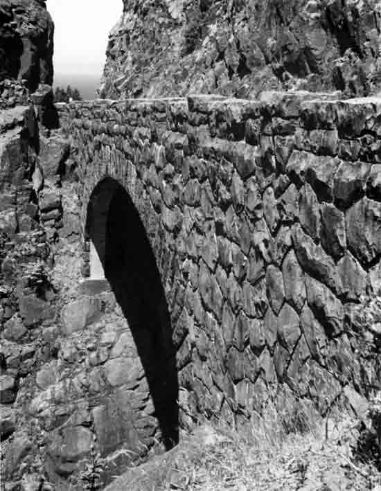
OLD COLUMBIA RIVER HIGHWAY BRIDGES
The old Columbia River Highway is the most historically significant twentieth century highway in Oregon. Built over a ten-year period from 1913 to 1922, the scenic highway was both environmentally sensitive to the magnificent Columbia River Gorge landscape (Figure 22) and ambitiously engineered. The highway was a major civic achievement and championed by such Oregon notables as Simon Benson, John B. Yeon, Samuel Hill, Julius Meier and Rufus Holman. Begun in the same year as the establishment of the State Highway Department (1913), the highway was developed under the auspices of that newly created organization in cooperation with the counties. The Columbia River Highway became a primary component of the initial state highway system adopted in 1914.
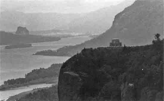
|
| FIGURE 22. The 80-mile gorge of the Columbia River east of Portland posed an obstacle to highway building. Constructed between 1913 and 1922, the scenic Columbia River Highway was a major engineering feat. Crown Point Vista House, an observatory and rest area on the old highway, was completed in 1918. |
The old Columbia River Highway is a showplace of early highway engineering. In addition to much of the roadway and its alignment, most of the major engineering features still exist, including over 25 bridges and viaducts, three tunnels, half-tunnels, long stretches of dry masonry retaining walls, rustic rubble parapets, and pedestrian overlooks. This cliff-face highway along one of America's major rivers was the dream of Samuel Hill, who envisioned a roadway similar to the historic roads of Europe but built to the most modern standards of the day. Samuel C Lancaster was the engineer in charge of the highway, particularly in Multnomah County. Along with John B. Yeon, Roadmaster, and Herbert Nunn, Lancaster surveyed, planned and constructed the highway.
The early bridges on the old highway in Multnomah and Hood River counties were designed under the direction of Sam Lancaster and Charles H. Purcell, Oregon's first state bridge engineer. The actual designs are attributed primarily to H. K. Billner and L. W. Metzger, designing engineers with the State Highway Department. As the highway was completed eastward into Wasco County, the bridge designs became those of Conde B. McCullough, who joined the department in 1919. The bridges on the Columbia River Highway comprise one of the finest extant collections of early twentieth century reinforced concrete structures in America. Frequently of the arch form, the bridges were designed with great care to blend with their settings and to be light, graceful, and strong. Some were major engineering feats and others innovative in reinforcement and design.
In December 1983, 55 miles of the old highway, along with its associated structures and other features, were listed on the National Register. Subsequently, the highway has also been recognized as a National Historic Civil Engineering Landmark by the American Society of Civil Engineers. The National Park Service, United States Department of the Interior, is currently considering the scenic Columbia River Highway for National Historic Landmark designation.
Twenty-six major highway bridges located in the Columbia River Highway Historic District are summarized and then highlighted on the following pages. The bridges are in chronological order by construction date, which tends to coincide with their locations on the old highway from west-to-east within the historic district boundaries. (The historic district also includes bridges and structures not listed or pictured herein, such as pedestrian bridges, highway culverts, small slab spans, tunnels, retaining walls and railings.)
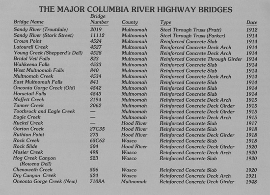
|
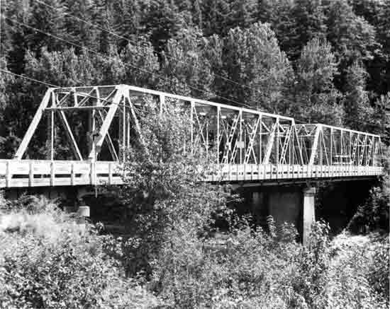 | ||
| Structure Number 2019 | Constructed - 1912 | |
| Crown Point Highway 125, M.P. 1.85 | Steel Through Truss (Pratt) | |
| Troutdale, Multnomah County | Ownership - State of Oregon | |
|
SANDY RIVER (TROUTBALE) BRIDGE This structure and the Stark Street crossing of the Sandy River form the traditional gateways from Portland to the Columbia River Gorge and the scenic Columbia River Highway. Originally constructed by Multnomah County, the two-span Sandy River Bridge at Troutdale is now in state ownership and is the oldest metal truss bridge in state ownership. The two identical Pratt trusses with riveted connections are 162 feet each. The bridge was designed by Waddell and Harrington, Consulting Engineers, Kansas City, and erected by the Oregon Bridge and Construction Company, Portland. A timber covered bridge spanned the Sandy River prior to the construction of the present bridge. | ||
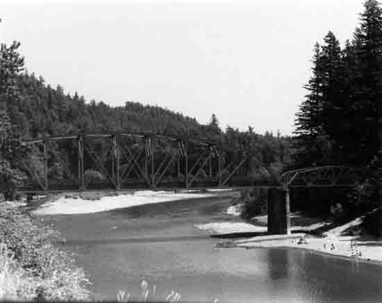 | ||
| Structure Number 11112 | Constructed - 1914 | |
| Stark Street Intersection with Crown Point Highway 125, M.P. 4.38 | Steel Through Truss (Parker) | |
| Gresham vicinity, Multnomah County | Ownership - Multnomah County | |
|
SANDY RIVER (STARK STREET) BRIDGE Constructed in 1914, the Stark Street Bridge was one of the first truss bridges constructed by the newly formed (1913) State Highway Department. Charles H. Purcell was the first state bridge engineer. The structure was built by George H. Griffin, Portland Bridge Company, at a cost of $21,000. The two-span structure consists of a 200-foot Parker truss main span and a 77-foot Warren pony truss secondary span. The truss connections are riveted. The construction of the bridge was expedited because the timber truss at this location collapsed ironically on Good Roads' Day, April 25, 1914. The Portland Automobile Club grounds were located near the bridge, and consequently, the bridge was also historically known as the Auto Club Bridge. | ||
 | ||
| Structure Number 4524 | Constructed - 1914 | |
| Crown Point Highway 125, M.P. 11.44 | Reinforced Concrete Slab | |
| Crown Point, Multnomah County | Ownership - State of Oregon | |
|
CROWN POINT VIADUCT The Crown Point Viaduct was the first structure started on the Multnomah County portion of the Columbia River Highway. Samuel C. Lancaster was the supervising engineer for both Multnomah County and the State Highway Department. Lancaster located the highway to encircle Crown Point, a promontory rising vertically 625 feet about the river. (Crown Point was designated a National Natural Landmark in August 1971.) The "half-viaduct" prevented unnecessary excavation or fill to establish a roadbed on the point. The structure is 560 feet long and consists of twenty-eight 20-foot reinforced concrete slab spans. Vista House, an observatory and rest stop dedicated to early Oregon pioneers, was completed on Crown Point in 1918. | ||
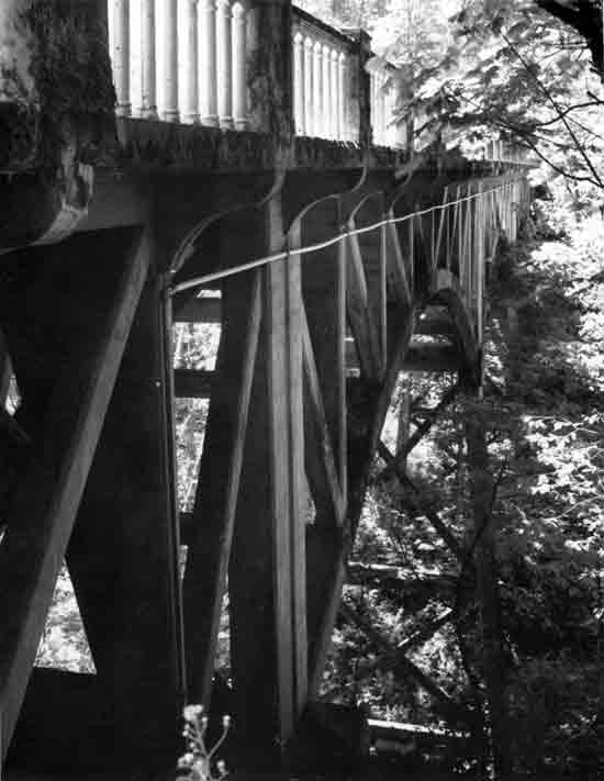 | ||
| Structure Number 4527 | Constructed - 1914 | |
| Crown Point Highway 125, M.P. 13.76 | Reinforced Concrete Deck Arch | |
| Latourell, Multnomah County | Ownership - State of Oregon | |
|
LATOURELL CREEK BRIDGE This arch structure is a three-span reinforced concrete braced-spandrel deck arch, each span 80 feet long. The bridge is credited to K.R. Billner, designing engineer with the State Highway Department. Billner adapted the principles of French bridge expert Armand Considere, who developed advanced measures of concrete reinforcement. A characteristic of the structure is its lightness, necessitated by the poor foundation conditions. The structure was built by the Pacific Bridge Company, Portland, and is located to take advantage of the view of Latourell Falls (249 feet) south of the bridge. The bridge is located in Guy W. Talbot State Park. | ||
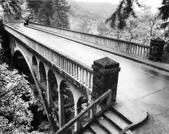 | ||
| Structure Number 4528 | Constructed - 1914 | |
| Crown Point Highway 125, M.P. 14.98 | Reinforced Concrete Deck Arch | |
| Latourell vicinity, Multnomah County | Ownership - State of Oregon | |
|
YOUNG CREEK (SHEPPERD'S DELL) BRIDGE This graceful reinforced concrete deck arch has a main arch span of 100 feet and consists of two parabolic arch ribs with open spandrels. Designed by K.R. Billner under the supervision of Samuel C. Lancaster, the structure was constructed by the Pacific Bridge Company, Portland, at a cost of $10,800. A stairwell and trail to the falls originates at the east end of the bridge. The structure is located in Shepperd's Dell State Park. Shepperd's Dell was donated as parkland by the owner, George Shepperd, a local farmer of modest means, in memory of his wife. | ||
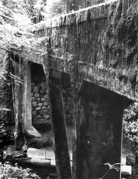 | ||
| Structure Number 823 | Constructed - 1914 | |
| Crown Point Highway 125, M.P. 16.01 | Reinforced Concrete Through Girder | |
| Bridal Veil vicinity, Multnomah County | Ownership - State of Oregon | |
|
BRIDAL VEIL FALLS BRIDGE One of only two known early reinforced concrete through girders in Oregon, the Bridal Veil Falls Bridge has a total length of 100 feet. The through girder is 50 feet long. The diagonally-placed support piers are another unique feature, so set to allow greater horizontal clearance under the structure. The bridge was designed by K.R. Billner, under the auspices of Samuel C. Lancaster. The Pacific Bridge Company of Portland built the structure. Bridal Veil Falls is downstream from the structure. When constructed, the bridge also spanned lumber flumes associated with the Bridal Veil Lumber Company. | ||
 | ||
| Structure Number 4533 | Constructed - 1914 | |
| Crown Point Highway 125, M.P. 19.17 | Reinforced Concrete Slab | |
| Multnomah Falls vicinity, Multnomah County | Ownership - State of Oregon | |
|
WAHKEENA FALLS BRIDGE This small reinforced concrete slab span is 18 feet long. The solid railing has bush-hammered panels for textural contrast, and the abutments are faced with dry masonry. It was designed by K.R. Billner and built by the Pacific Bridge Company of Portland. The small bridge is located near Wahkeena Falls (vertical drop 242 feet) and is in a Mount Hood National Forest recreation site. | ||
 | ||
| Structure Number 840 | Constructed - 1914 | |
| Crown Point Highway 125, M.P. 19.50 | Reinforced Concrete Slab | |
| Multnomah Falls vicinity, Multnomah County | Ownership - State of Oregon | |
|
WEST MULTNOMAH FALLS VIADUCT Both east and west of Multnomah Falls are long "half-viaducts" or "side-hill viaducts," built to carry the roadway in the narrow area between the steep hillside and railroad. With the uphill side of the viaduct resting on the slope and the downhill side elevated on columns, these viaducts are a successful alternative to cutting into the unstable slopes to excavate a roadbed. The West Multnomah Falls Viaduct is 400 feet long and consists of twenty 20-foot slab spans. The viaduct was designed by K.R. Billner, under the supervision of S.C. Lancaster, and was built by the Pacific Bridge Company, Portland. | ||
 | ||
| Structure Number 4534 | Constructed - 1914 | |
| Crown Point Highway 125, M.P. 19.72 | Reinforced Concrete Deck Arch | |
| Multnomah Falls vicinity, Multnomah County | Ownership - State of Oregon | |
|
MULTNOMAH CREEK BRIDGE The Multnomah Creek Bridge, near the 620-foot drop of Multnomah Falls, is a noteworthy short-span arch and is a significant component of the old Columbia River Highway. This reinforced concrete deck arch is 67 feet in length. The barrel arch has solid spandrel walls and is 40 feet in length. The bridge was designed by K.R. Billner under the supervision of C.H. Purcell, State Bridge Engineer, and S.C. Lancaster, Assistant State Highway Engineer. It was constructed by the Pacific Bridge Company of Portland. The Multnomah Falls Lodge (in photo background) was completed in 1925 by the City of Portland. In the Cascadia or National Park rustic style, the stone lodge was designed by prominent Portland architect A.E. Doyle. | ||
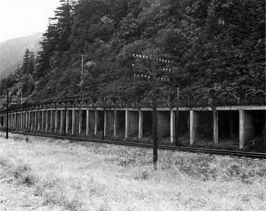 | ||
| Structure Number 841 | Constructed - 1914 | |
| Crown Point Highway 125, M.P. 20.03 | Reinforced Concrete Slab | |
| Multnomah Falls vicinity, Multnomah County | Ownership - State of Oregon | |
|
EAST MULTNOMAH FALLS VIADUCT The East Multnomah Falls Viaduct is the longest viaduct on the old highway and is 860 feet in length. Consisting of 86 10-foot reinforced concrete slab spans, the East Multnomah Falls Viaduct is similar to the West Multnomah Falls Viaduct. The light, ornate arched railing adds to the appearance of the viaduct. This railing design is used on only four structures on the old Columbia River Highway. | ||
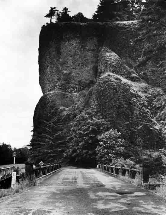 | ||
| Structure Number 4542 | Constructed - 1914 | |
| Crown Point Highway 125, M.P. 21.93 (Bypassed) | Reinforced Concrete Slab | |
| Oneonta, Multnomah County | Ownership - State of Oregon | |
|
ONEONTA GORGE CREEK (OLD) BRIDGE This reinforced concrete slab bridge was designed by K.R. Billner and constructed by the Pacific Bridge Company of Portland. It is 80 feet in length and consists of four 20-foot spans. A stairwell is located at the west end for access to the creek and trail. As constructed, the highway at the bridge passed into the Oneonta Tunnel. The tunnel was closed in the late 1940s, and a new bridge parallel to this bridge was built. | ||
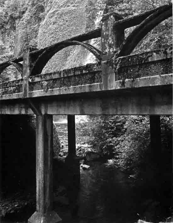 | ||
| Structure Number 4543 | Constructed - 1914 | |
| Crown Point Highway 125, M.P. 22.21 | Reinforced Concrete Slab | |
| Oneonta vicinity, Multnomah County | Ownership - State of Oregon | |
|
HORSETAIL FALLS BRIDGE Very similar in design to the Oneonta Gorge Creek Bridge, the Horsetail Falls Bridge is a 60-foot reinforced concrete slab span type, consisting of three 20-foot spans. The ornate arch railing design is repeated on the Oneonta Gorge Creek Bridge, East Multnomah Falls Viaduct and West Multnomah Falls Viaduct. (The only other known use of this railing design in Oregon is the Steinman Overcrossing, Jackson County, also constructed in 1914.) The structure, built in 1914, is attributed to K.R. Billner, designing engineer at the State Highway Department, under the supervision of Samuel C. Lancaster. The contractor was the Pacific Bridge Company of Portland. (Horsetail Falls, located near the bridge, has a vertical drop of 221 feet.) | ||
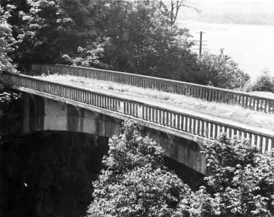 | ||
| Structure Number 2194 | Constructed - 1915 | |
| Crown Point Highway 2 (Interstate 84), M.P. 38.98 (Bypassed) | Reinforced Concrete Deck Arch | |
| Bonneville vicinity, Multnomah County | Ownership - State of Oregon | |
|
MOFFETT CREEK BRIDGE This structure was one of the outstanding engineering features on the Columbia River Highway. The low-rise reinforced concrete deck arch has a clear span of 170 feet and rises only 17 feet in that distance. The overall length of the structure is 205 feet. When it was constructed in 1915, it was the longest three-hinged flat arch bridge in the United States. The three hinges are massive cast iron with 4-1/2-inch steel pins. The bridge is attributed to L.W. Metzger, a designer under the guidance of C.H. Purcell, the first state bridge engineer. The bridge was bypassed in 1950 and is now abandoned. | ||
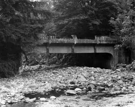 | ||
| Structure Number 2062 | Constructed - 1915 | |
| Columbia River Highway 2 (Interstate 84), M.P. 40.27 (Bypassed) | Reinforced Concrete Deck Girder | |
| Bonneville vicinity, Multnomah County | Ownership - State of Oregon (Fish and Wildlife Commission) | |
|
TANNER CREEK BRIDGE Bypassed and no longer in use, the Tanner Creek Bridge is a reinforced concrete deck girder, 60 feet in length. The bridge is located near the Interstate 84 entrance to the Bonneville Dam and is now owned by the Oregon Fish and Wildlife Commission. Completed in 1915, the bridge was constructed by the State Highway Department. Charles H. Purcell was the state bridge engineer, and Samuel Lancaster was the engineer for the Columbia River Highway. | ||
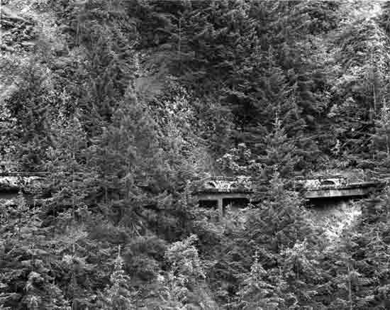 | ||
| Structure Numbers Unknown | Constructed - 1915 | |
| Columbia River Highway 2 (Interstate 84), M.P. 41.25 (Bypassed) | Reinforced Concrete Deck Girder | |
| Bonneville vicinity, Multnomah County | Ownership - State of Oregon | |
|
TOOTHROCK AND EAGLE CREEK VIADUCTS These reinforced concrete deck girder viaducts are located on an abandoned portion of the old highway above the Toothrock Tunnel (1936), near Bonneville Dam. Although partially hidden by trees and other vegetation, the old viaducts are visible from the westbound lanes of Interstate 84. The viaducts curve around the mountainside and are about 224 feet long and 23 feet wide. Charles H. Purcell was the state bridge engineer. The viaducts were abandoned when the new alignment of the highway was completed (including the Toothrock Tunnel), in conjunction with the construction of the Bonneville Dam in the late 1930s. | ||
 | ||
| Structure Number Unknown | Constructed - 1915 | |
| Exit Road, Columbia River Highway 2 (Interstate 84), M.P. 41.55 | Reinforced Concrete Deck Arch | |
| Bonneville vicinity, Multnomah County | Ownership - State of Oregon | |
|
EAGLE CREEK BRIDGE The Eagle Creek Bridge is one of the most attractive structures on the original Columbia River Highway. The historic feeling is enhanced by the masonry facing and stone parapets. The reinforced concrete deck arch is 100 feet in length. The semi-circular arch has three rib arches and is 60 feet in length. At the ends of the arch span are 20-foot concrete slab spans. A pedestrian overlook is at the west end. The bridge was designed by K.R. Billner, Designing Engineer, State Highway Department. The bridge serves the eastbound exit from Interstate 84 to the state fish hatchery and recreation areas at Eagle Creek. | ||
 | ||
| Structure Number Unknown | Constructed - 1917 | |
| Forest Trail 405 from the Eagle Creek Campground | Reinforced Concrete Slab | |
| Cascade Locks vicinity, Hood River Count | Ownership - Mount Hood National Forest, United States Forest Service | |
|
RUCKEL CREEK BRIDGE The Ruckel Creek Bridge is one of the smaller structures built on the scenic Columbia River Highway. A simple slab span, 10 feet in length, was all that was required to cross Ruckel Creek. The concrete abutments are faced with stone, and the railing is the arched masonry parapet commonly bordering the scenic highway in the Columbia Gorge. The bridge plans are signed by L.W. Metzger, State Highway Department. The bridge now serves a Mount Hood National Forest trail, accessible from the Eagle Creek Campground. | ||
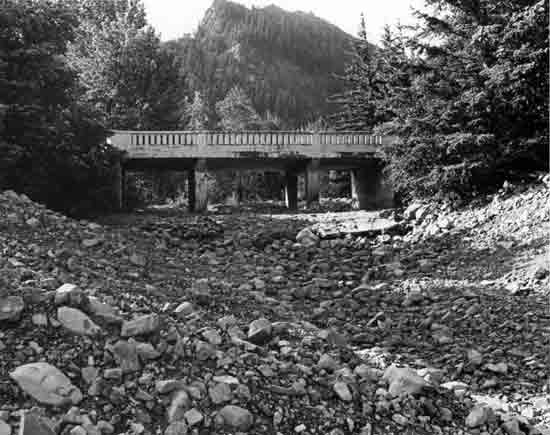 | ||
| Structure Number 27C35 | Constructed - 1918 | |
| Wyeth County Road 605 | Reinforced Concrete Slab | |
| Wyeth vicinity, Hood River County | Ownership - Hood River County | |
|
GORTON CREEK BRIDGE The Gorton Creek Bridge is a 50-foot reinforced concrete slab structure, consisting of three slab spans (two 15-foot and one 20-foot spans). This simple bridge has a standard precast concrete railing with vertical openings, posts and caps. The bridge was designed by L. W. Metzger and was constructed by A.D. Kern for the State Highway Department. Now located on a county road, the bridge is visible from Interstate 84. A Mount Hood National Forest campground is east of the bridge. Gorton Creek was named for Edwin Gorton, who had a homestead along its banks in the 1890s. | ||
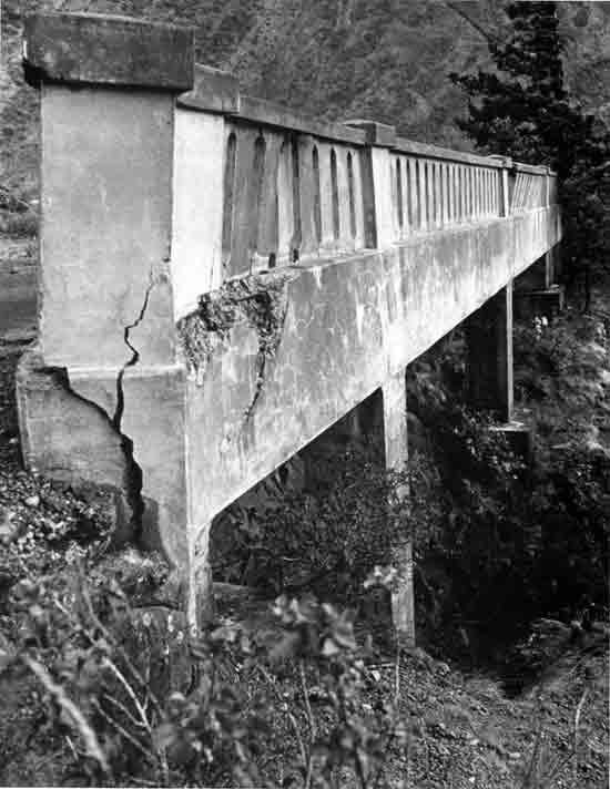 | ||
| Structure Number 273 | Constructed - 1918 | |
| Columbia River Highway 2 (Interstate 84), M.P. 60 (approx.) (Bypassed) | Reinforced Concrete Deck Girder | |
| Hood River vicinity, Hood River County | Ownership - State of Oregon | |
|
RUTHTON POINT VIADUCT This 50-foot half-viaduct is located on an abandoned section of the old highway west of Hood River at Ruthton Point. Near the westbound lanes of Interstate 84, the reinforced concrete deck girder structure consists of three spans—two 20-foot and one 10-foot in length. L. W. Metzger was the designing engineer for the State Highway Department. | ||
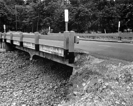 | ||
| Structure Number 65C63 | Constructed - 1918 | |
| Hood River (County) Road | Reinforced Concrete Slab | |
| Mosier, Wasco County | Ownership - Wasco County | |
|
ROCK CREEK BRIDGE The Rock Creek Bridge is a 44-foot reinforced concrete slab span structure, consists of two 22-foot slabs. The simple wood railing may not be original, but echoes a wood railing design used along long stretches of the highway in lieu of the rustic arched masonry parapets. The Rock Creek Bridge is now in county ownership, but was originally built by the State Highway Department. L. W. Metzger was the designing engineer. | ||
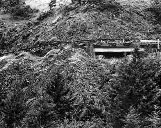 | ||
| Structure Number 504 | Constructed - 1920 | |
| Old Columbia River Highway Drive (County Road) | Reinforced Concrete Deck Girder | |
| Hood River vicinity, Hood River County | Ownership - Hood River County | |
|
ROCK SLIDE VIADUCT Only 34 feet long, the Rock Slide Viaduct is a short structure not far from the Mosier Twin tunnels. Although visible from Interstate 84, the viaduct is not readily apparent when driving the old highway (now a Hood River County road). The uninterrupted roadway surface and the continuous arched rubble parapet railing across the viaduct make it difficult to identify the bridge span from the road. Noted Oregon State Bridge Engineer Conde B. McCullough had recently joined the Highway Department and signed the structure plans. | ||
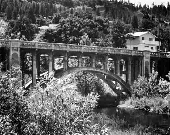 | ||
| Structure Number 498 | Constructed - 1920 | |
| Mosier-The Dalles Highway 292, M.P. 0.64 | Reinforced Concrete Deck Arch | |
| Mosier, Wasco County | Ownership - State of Oregon | |
|
MOSIER CREEK BRIDGE A notable feature on the old Columbia River Highway, this reinforced concrete deck arch structure is 182 feet long and consists of a 110-foot rib arch and concrete slab approaches. It was designed by Conde B. McCullough, State Bridge Engineer. Lindstrom and Feigenson, Contractors, were the builders. | ||
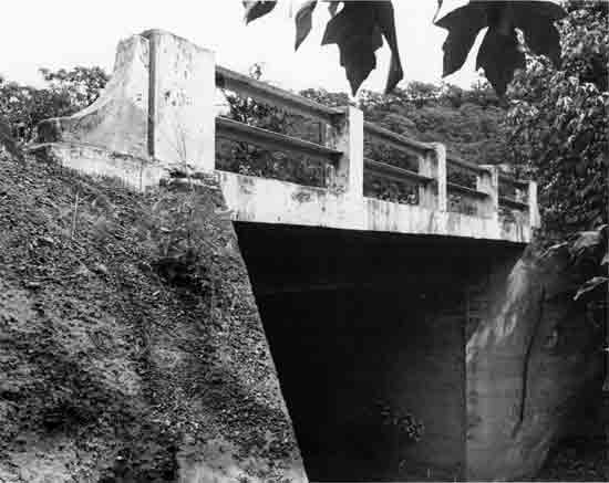 | ||
| Structure Number 523 | Constructed - 1920 | |
| Mosier-The Dalles Highway 292, M.P. 5.97 | Reinforced Concrete Slab | |
| Rowena vicinity, Wasco County | Ownership - State of Oregon | |
|
HOG CREEK CANYON (ROWENA DELL) BRIDGE This small bridge is a 20-foot reinforced concrete slab span and was designed under the auspices of Conde B. McCullough, State Bridge Engineer. The railing design is unique to the structures in the historic district area. Rowena Dell, a canyon of basaltic rock between Rowena and Mosier, was originally known as Hog Creek Canyon. Local legend is that herds of hogs were grazed in the canyon to eradicate the rattlesnakes. After the highway was built, a more elegant name was desired, and Rowena Dell was selected. | ||
 | ||
| Structure Number 506 | Constructed - 1920 | |
| Mosier-The Dalles Highway 292, M.P. 14.99 | Reinforced Concrete Slab | |
| The Dalles vicinity, Wasco County | Ownership - State of Oregon | |
|
CHENOWETH CREEK BRIDGE This 60-foot reinforced concrete slab span structure is the eastern boundary of the Columbia River Highway Historic District and lies near The Dalles city limits. The Chenoweth Creek Bridge consists of three 20-foot spans. The original railing has been replaced with metal guardrail. A.D. Kern of Portland constructed the bridge for the State Highway Department. Conde B. McCullough was the state bridge engineer. Chenoweth Creek was named for Justin Chenoweth, a prominent Oregon pioneer. | ||
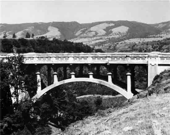 | ||
| Structure Number 524 | Constructed - 1921 | |
| Mosier-The Dalles Highway 292, M.P. 6.64 | Reinforced Concrete Deck Arch | |
| Rowena vicinity, Wasco County | Ownership - State of Oregon | |
|
DRY CANYON CREEK BRIDGE The Dry Canyon Creek Bridge rivals Shepperd's Dell Bridge in Multnomah County for excellence in design and compatibility with its environmental setting. This small 75-foot reinforced concrete rib arch spans a deep ravine 600 feet above the Columbia River. The open spandrel arch structure was designed by Conde B. McCullough, State Bridge Engineer, and is one of his early arch designs. The bridge was built by state forces and supervised by resident bridge engineer Christ Fauerso. | ||
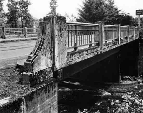 | ||
| Structure Number 7108A | Constructed - 1948 | |
| Crown Point Highway 125, M.P. 21.93 | Reinforced Concrete Deck Girder | |
| Oneonta, Multnomah County | Ownership - State of Oregon | |
|
ONEONTA GORGE CREEK (NEW) BRIDGE The Oneonta Gorge Creek replacement bridge is a 48-foot reinforced concrete deck girder, completed in 1948. This bridge was constructed to replace the old bridge (Oneonta Gorge Creek Bridge, #4542), bypassed when the Oneonta Tunnel was closed. The revised highway alignment skirts the tunnel to the north and also required the relocation of the railroad tracks. The open steel bar railing adds a distinctive feature to this short bridge. The bridge was designed by Glenn S. Paxson, State Bridge Engineer. | ||
COVERED BRIDGES
Oregon has the largest collection of covered bridges in the West and one of the largest in the nation. The covered bridge-building tradition in Oregon dates from the 1850s. Out of necessity, pioneers built with the materials at hand. Douglas fir was abundant in western Oregon and well-suited to bridge construction. Housings were placed over the timber truss and chords to protect these members from the damp climate of western Oregon, thus increasing their useful life. The heyday of covered bridge building in Oregon occurred between 1905 and 1925, when there were an estimated 450 covered bridges in the state.
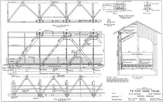
|
| FIGURE 23. This 1934 standard plan for a 75-foot Howe truss covered bridge is one of several plans developed by the State Highway Department. These standard designs for covered bridges were not only used by the state, but were also available to local governments. Many of Oregon's surviving covered bridges are examples of standard state designs. |
By 1977, the number of covered bridges in the state had dwindled to 56 structures. Because of public concern for the decreasing number of covered bridges, the State Historic Preservation Office nominated the remaining covered bridges to the National Register. The nomination of the Oregon Covered Bridge Thematic Group was coordinated with the bridge owners—cities, counties and private parties. (Although once common on state routes, the last state-owned housed structure, Ritner Creek Bridge in Polk County, was relocated in 1976 and turned over to the county.)
At the express request of the city and county owners concerned, ten of Oregon's covered bridges were excluded from the thematic group nomination. The excluded covered bridges were the following:
| Name | County |
| North Fork Siuslaw River (Meadows) | Lane |
| Pass Creek (Drain) | Douglas |
| Calapooya Creek (Rochester) | Douglas |
| Crabtree Creek (Hoffman) | Linn |
| Thomas Creek (Jordan) | Linn |
| South Myrtle Creek (Neal Lane) | Douglas |
| Thomas Creek (Gilkey) | Linn |
| Little River (Cavitt Creek) | Douglas |
| Crabtree Creek (Bohemian Hall) | Linn |
| Thomas Creek (Shimanek) | Linn |
In November 1979, 46 of Oregon's 56 covered bridges were subsequently listed on the National Register.
Since 1979, four covered bridges have been lost due to floods and displacements:
| Name | County |
| North Fork Siuslaw River (Meadows) | Lane |
| Siletz River (Sam's Creek) | Lincoln |
| Yaquina River (Elk City) | Lincoln |
| Mosby Creek (Brumbaugh) | Lane |
Three of the lost covered bridges were listed on the National Register. The North Fork Siuslaw River (Meadows) Covered Bridge was not listed at the request of Lane County.
Currently, the population of covered bridges in Oregon numbers 52.* All of these covered bridges are illustrated in this document, except for the Coast Fork Willamette River (Chambers) Covered Bridge, Lane County, which was purposely not included. Although listed on the National Register, Chambers is a railroad bridge, a structure use not included in this historic highway bridges study.
*This total does not include the Johnson Creek (Cedar Crossing) Bridge, built by Multnomah County on S.E. Deardorff Road in 1982. Although housed, this attractive contemporary structure contains no truss and is a timber (Glulam) stringer structure.
The remaining 42 highway covered bridges listed on the National Register in 1979 are summarized below and shown on the following pages. The bridges are arranged chronologically by date of construction. (Appendices C and D are useful supplements to this section as they list the covered bridges by location and by structure type.)
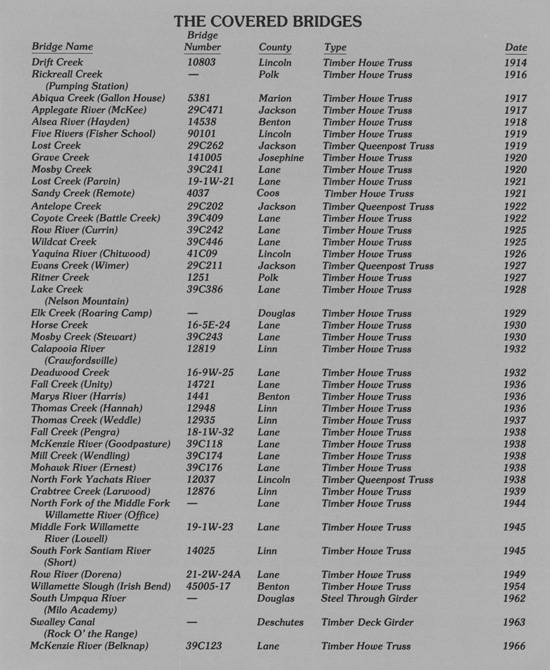
|
The nine covered bridges excluded from the covered bridges nomination are shown in other places in this document. The ODOT historic bridges study evaluated five of the bridges for National Register eligibility—Pass Creek (Drain), Calapooya Creek (Rochester), Crabtree Creek (Hoffman), South Myrtle Creek (Neal Lane), and Thomas Creek (Gilkey). These five covered bridges are included in the Study Identified Bridges section. Because replacement was urgently needed, a request for determination of eligibility on the Thomas Creek (Jordan) Covered Bridge was specially prepared. That bridge was subsequently found National Register eligible and is included in the Other Historic Bridges section. The relatively recent construction dates of the Little River (Cavitt Creek), 1943; Crabtree Creek (Bohemian Hall), 1947; and Thomas Creek (Shimanek), 1966, covered bridges excluded them from the cut-off date of the historic bridges study. These bridges were, however, examined because of their special type and are shown with the Notable Post-1940 Construction Highway Bridges in Appendix F.
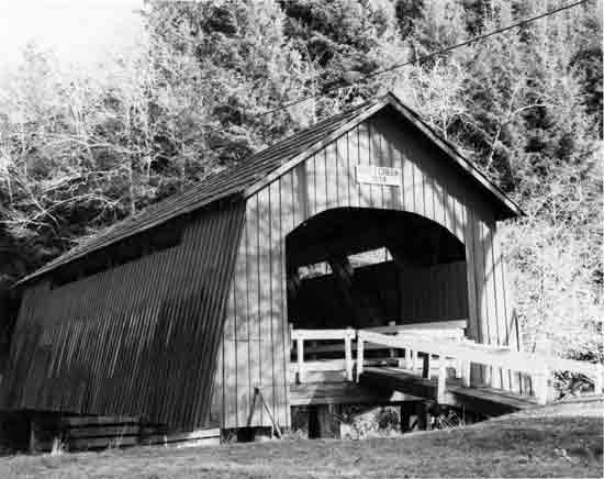 | ||
| Structure Number 10803 | Constructed - 1914 | |
| Drift Creek County Road | Timber Through Truss (Howe) Covered Bridge | |
| Lincoln City vicinity, Lincoln County | Ownership - Lincoln County | |
|
DRIFT CREEK BRIDGE The Drift Creek Bridge is the oldest covered span in Oregon. It also has the distinction of being the covered bridge closest to the Oregon Coast, only 1-1/2 miles from the Pacific Ocean. Built by Lincoln County, the 66-foot housed Howe truss structure cost about $1,800 in 1914. The bridge is closed to vehicular traffic but serves pedestrian traffic. The old bridge has flared board-and-batten siding, arched portals, ribbon daylighting and wooden flooring. Lincoln County has maintained the bridge as a historical exhibit-in-place since 1965. | ||
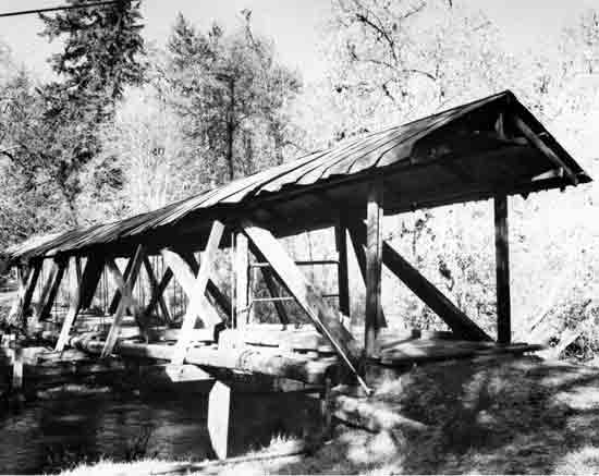 | ||
| Structure Unnumbered | Constructed - 1916 | |
| Private Road off Robb Mill County Road 763 | Timber Through Truss (Howe) Covered Bridge | |
| Dallas vicinity, Polk County | Ownership - Private | |
|
RICKREALL CREEK (PUMPING STATION) BRIDGE The plainest of Oregon's covered bridges is the Pumping Station Bridge near Dallas in Polk County. Of very early construction (1916), the 84-foot covered bridge includes an exposed Howe truss. (The sides of the bridge were originally covered, but the corrugated metal siding has been removed.) The bridge was built by the Dallas Water Company, a private company owned and operated by H. V. Gates. The narrow bridge was used for traffic crossing the creek that served the water works. The roof is covered with corrugated metal. The ends are open as well, and cantilevered buttresses (also called "sway braces") strengthen the sides of the structure. | ||
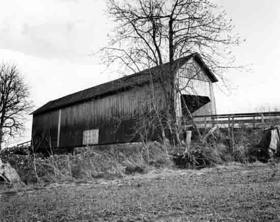 | ||
| Structure Number 5381 | Constructed - 1917 | |
| Gallon House County Road 647 | Timber Through Truss (Howe) Covered Bridge | |
| Silverton vicinity, Marion County | Ownership - Marion County | |
|
ABIQUA CREEK (GALLON HOUSE) BRIDGE The Gallon House Bridge is the last remaining covered bridge in Marion County and one of the oldest covered bridges in Oregon. This structure is an 84-foot housed Howe truss with a timber roadway deck. Gallon House has rectangular portals, narrow ribbon openings at the eaves, and board-and-batten siding. The bridge is open to traffic. Marion County completed major repairs to the bridge in 1985. According to local tradition, the bridge owes its name to an unauthorized liquor dispensary which operated at the north approach prior to prohibition. During that time, Silverton to the south was a dry town, while Mount Angel to the north was not. | ||
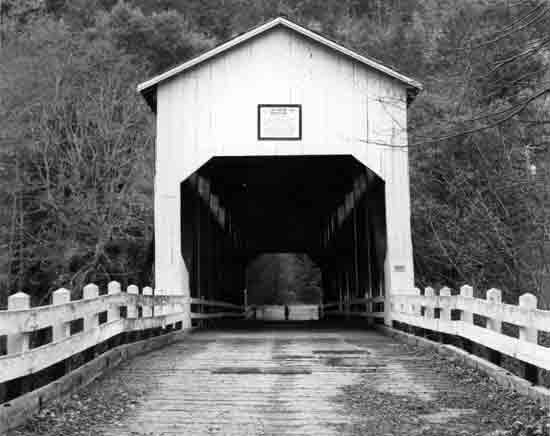 | ||
| Structure Number 29C471 | Constructed - 1917 | |
| Applegate County Road | Timber Through Truss (Howe) Covered Bridge | |
| Ruch vicinity, Jackson County | Ownership - Jackson County | |
|
APPLEGATE RIVER (MCKEE) BRIDGE The fourth oldest covered bridge in Oregon, the McKee Bridge was built in 1917 by contractor Jason Hartman of Jacksonville on land donated by stage station operator, Adelbert "Deb" McKee. The bridge was a rest stop at the half-way point between Jacksonville and the Blue Ledge Copper Mine. Relief horses were kept at this location for hauling ore in the early days of the bridge. The 122-foot housed Howe truss structure was closed to vehicular traffic in 1956. Local volunteers have since maintained the bridge. McKee Picnic Ground, a Rogue National Forest facility, is at the west end of the bridge along the Applegate River. The bridge contains truncated rectangular portal arches, ribbon openings at the eaves on both sides, five irregularly spaced windows on the south elevation, and exposed cantilevered buttresses. | ||
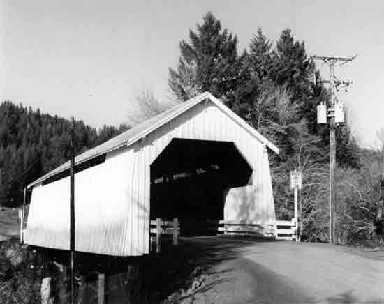 | ||
| Structure Number 14538 | Constructed - 1918 | |
| Hayden County Road | Timber Through Truss (Howe) Covered Bridge | |
| Alsea vicinity, Benton County | Ownership - Benton County | |
|
ALSEA RIVER (HAYDEN) BRIDGE The 91-foot Hayden Bridge is among the oldest covered bridges in the state. Seven covered bridges in Oregon remain that were constructed before 1920, including the Hayden Bridge. In addition, the Hayden Bridge is the oldest of Benton County's three covered bridges, all Howe trusses. Its original portal design has been changed to allow larger loads. Narrow ribbon openings under the side wall eaves allow some interior light, and the sides are flared. | ||
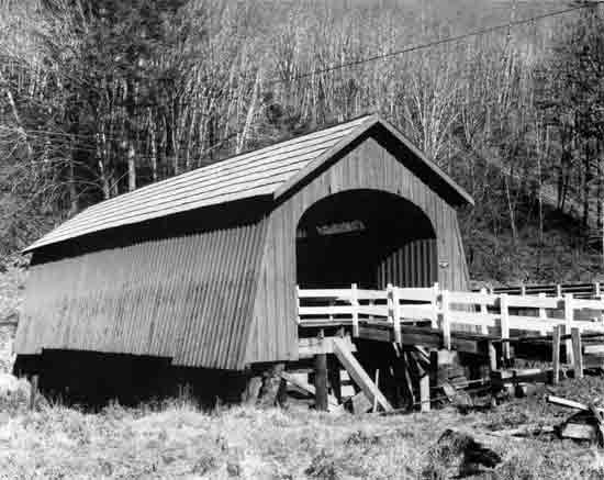 | ||
| Structure Number 90101 | Constructed - 1919 | |
| Five Rivers County Road | Timber Through Truss (Howe) Covered Bridge | |
| Fisher, Lincoln County | Ownership - Lincoln County | |
|
FIVE RIVERS (FISHER SCHOOL) BRIDGE An early covered span, the Fisher School Bridge was constructed in 1919 and incorporates a 72-foot housed Howe truss. Lincoln County contracted with Otis Hamer to build the bridge for about $2,500. Design features include semi-elliptical portal arches, ribbon openings, flared side walls, wood piers and cribs. The bridge is now closed to vehicles, and a modern concrete bridge nearby handles daily traffic. Five Rivers is named for the multiplicity of creeks which feed this tributary of the Alsea River. | ||
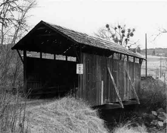 | ||
| Structure Number 29C262 | Constructed - 1919 | |
| Lost Creek County Road | Timber Through Truss (Queenpost) Covered Bridge | |
| Lakecreek vicinity, Jackson County | Ownership - Jackson County | |
|
LOST CREEK BRIDGE The Lost Creek Bridge at 39 feet is the shortest of the Oregon covered bridges and is also one of the oldest. The bridge has been bypassed and is closed to vehicular traffic. The housed queenpost truss is modified by cross members within the truss arrangement. The bridge does not have the usual portal arches and is open at the ends. Other architectural features include ribbon openings at the eaves and exposed cantilever buttresses. | ||
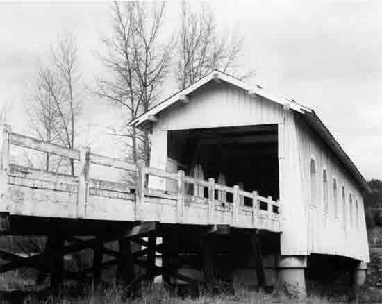 | ||
| Structure Number 141005 | Constructed - 1920 | |
| Sunny Valley-Placer County Road | Timber Through Truss (Howe) Covered | |
| Bridge Sunny Valley vicinity, Josephine County | Ownership - Josephine County | |
|
GRAVE CREEK BRIDGE Because of its proximity to Interstate 5, the Grave Creek Bridge is Oregon's most viewed covered bridge. Originally built on the Pacific Highway (U.S. 99) in 1920, the structure was built by the State Highway Department and is a standardized state covered bridge plan. The housed Howe truss is 105 feet long. The original semi-elliptical portal arches have been reshaped to provide increased height clearance. Architectural features include false end heads. The Grave Creek Bridge is the only remaining covered bridge in Josephine County. | ||
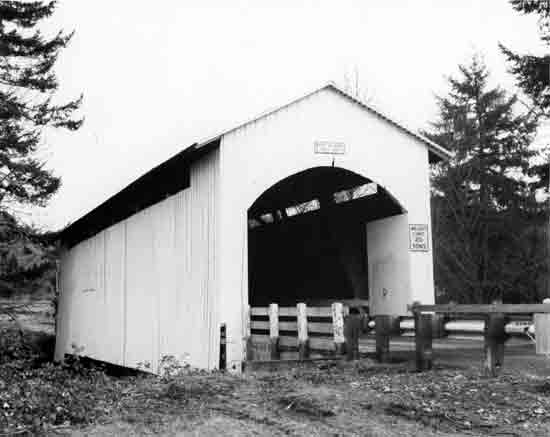 | ||
| Structure Number 39C241 | Constructed - 1920 | |
| Layng County Road 2542 | Timber Through Truss (Howe) Covered Bridge | |
| Cottage Grove vicinity, Lane County | Ownership - Lane County | |
|
MOSBY CREEK BRIDGE Mosby Creek Bridge is the oldest in Lane County's collection of eighteen covered highway bridges, the largest of any county in Oregon. Built in 1920 at a cost of $4,125, the Mosby Creek Bridge is a housed Howe truss, 90 feet in length. Typical of the smaller bridges in Lane County, the bridge has semi-circular portal arches, ribbon openings at the roof line, and board-and-batten cladding. | ||
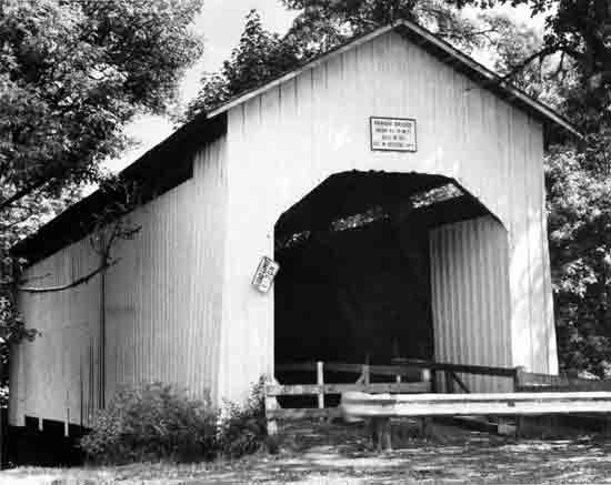 | ||
| Structure Number 19-1W-21 | Constructed - 1921 | |
| Parvin County Road 6122 | Timber Through Truss (Howe) Covered Bridge | |
| Dexter vicinity, Lane County | Ownership - Lane County | |
|
LOST CREEK (PARVIN) BRIDGE The Parvin Covered Bridge was constructed by Lane County in 1921 at a cost of $3,600. George W. Breeding was the contractor. The structure is a 75-foot housed Howe truss and is a fine example in Oregon's covered bridge tradition. The current bridge replaced a span erected at this site in the late 1880s. The bridge was named for an early pioneer family. Distinctive features include the ribbon openings under the eaves and the truncated rectangular portal arches. The bridge was closed to vehicular traffic in 1974 and now serves as a footbridge for local residents. | ||
 | ||
| Structure Number 4037 | Constructed - 1921 | |
| Sandy Creek County Road | Timber Through Truss (Howe) Covered Bridge | |
| Remote, Coos County | Ownership - Coos County | |
|
SANDY CREEK (REMOTE) BRIDGE The 60-foot Remote Bridge is the only remaining covered span in Coos County. Bypassed in 1949, the Remote Bridge was formerly in state ownership on State Route 42. The truss consists of two crossed Howe truss members on each chord, a rarity in short covered trusses. The design of the bridge with large side openings is similar to those found in Linn County. Until recently, the bridge was in poor condition but has now been restored by volunteers. In September 1984, the bridge was dedicated as a Coos County park and serves pedestrian uses. | ||
 | ||
| Structure Number 29C202 | Constructed - 1922 | |
| Antelope County Road | Timber Through Truss (Queenpost) Covered Bridge | |
| Medford vicinity, Jackson County | Ownership - Jackson County | |
|
ANTELOPE CREEK BRIDGE The Antelope Creek Bridge contains a 58-foot housed queenpost truss, modified by the addition of a kingpost. Three of Jackson County's housed spans incorporate the queenpost truss. Now bypassed and unused for vehicular traffic, the Antelope Creek Bridge receives little care and attention. The paint on the ends by the semi-circular portal arches is peeling, and the unpainted sides are weathering. Ribbon openings extend the full length on the side walls under the eaves. Three exposed cantilevered buttresses strengthen the structure. | ||
 | ||
| Structure Number 39C409 | Constructed - 1922 | |
| Battle Creek County Road 4082 | Timber Through Truss (Howe) Covered Bridge | |
| Crow vicinity, Lane County | Ownership - Lane County | |
|
COYOTE CREEK (BATTLE CREEK) BRIDGE The Coyote Creek Bridge goes by many names, including Battle Creek Bridge (after the road and creek name) and, less often, Swing Log Bridge. The source and meaning of the name Swing Log are unknown but intriguing, nonetheless. This structure contains a 60-foot housed Howe truss. The principal design elements are the housed buttresses, ribbon openings under the eaves, and rectangular portal arches. The Coyote Bridge is on the route of the original Territorial Road (1851). The structure still serves vehicular traffic, although trucks are prohibited. | ||
 | ||
| Structure Number 39C242 | Constructed - 1925 | |
| Layng County Road 2542 | Timber Through Truss (Howe) Covered Bridge | |
| Cottage Grove vicinity, Lane County | Ownership - Lane County | |
|
ROW RIVER (CURRIN) BRIDGE Named after an early pioneer family in the area, the Currin Bridge was constructed in 1925 and is a 105-foot housed Howe truss. An earlier covered bridge at this site was completed in 1883 by veteran bridge builder, Nels Roney. The Currin Bridge has the distinction of being Oregon's only span with white-painted portals and red sides. Its architectural design is the standard Lane County covered bridge. The bridge has been bypassed and is closed to vehicular traffic. | ||
 | ||
| Structure Number 39C446 | Constructed - 1925 | |
| Austa County Road | Timber Through Truss (Howe) Covered Bridge | |
| Richardson vicinity, Lane County | Ownership - Lane County | |
|
WILDCAT CREEK BRIDGE Constructed in 1925 by Lane County, the bridge crosses Wildcat Creek near its confluence with the Siuslaw River. The housed Howe truss is 75 feet long. The portals have semi-elliptical arches, and ribbon openings extend nearly the length of the side walls under the eaves. A second long narrow opening on the east wall provides a view of oncoming traffic. Decorative brackets are at the ends of the side walls at the eaves. The bridge is open to vehicular traffic, except for trucks. The boat ramp nearby provides access to the Siuslaw River for fishermen. | ||
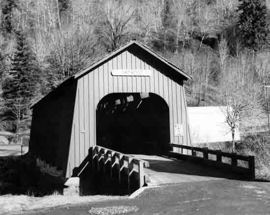 | ||
| Structure Number 41C09 | Constructed - 1926 | |
| Chitwood County Road 427, off the Corvallis-Newport Highway 33, M.P. 18.11 | Timber Through Truss (Howe) Covered Bridge | |
| Chitwood, Lincoln County | Ownership - Lincoln County | |
|
YAQUINA RIVER (CHITWOOD) BRIDGE Scheduled for replacement and destruction only a few years ago, the Chitwood Covered Bridge is a historic preservation success story in Oregon. Because of strong local sentiment in Lincoln County for saving the bridge, a restoration alternative was chosen to improve the condition of the bridge. CM2M-Hill, an engineering firm from Corvallis, supervised the federally-funded rehabilitation project, completed in 1984. Aubrey Mountain Construction, Eugene, was the contractor. (The above photo shows the restored bridge.) The Chitwood Bridge was originally built in 1926 by Lincoln County, and the design is attributed to A.E. Marvin. The housed Howe truss is 96 feet long. The simple design—semi-elliptical portal arches, flared sides, and ribbon opening under the eaves—is characteristic of the Lincoln County covered bridges. The community of Chitwood, named for Joshua Chitwood, an early resident, was once a thriving railroad town, but is now a ghost town with only a few residents left. | ||
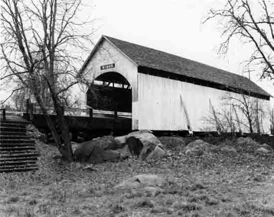 | ||
| Structure Number 29C211 | Constructed - 1927 | |
| East Evans Creek County Road | Timber Through Truss (Queenpost) Covered Bridge | |
| Wimer, Jackson County | Ownership - Jackson County | |
|
EVANS CREEK (WIMER) BRIDGE One of only a few Oregon covered bridges located in a city or community center, the Wimer Covered Bridge is an 85-foot housed queenpost truss. The original bridge at this site was erected in 1892. The present bridge was constructed in 1927, but was largely rebuilt in 1962. The bridge was constructed for the county by the Hartman family members of Jacksonville. The bridge includes exposed exterior buttresses, ribbon openings, and semi-circular portal arches. A small park is adjacent to the bridge. It is the only covered bridge in Jackson County open to vehicular traffic. The community of Wimer was established in the 1880s and was named for members of the Wimer family, early residents in the area. | ||
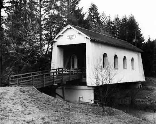 | ||
| Structure Number 1251 | Constructed - 1927 | |
| Minnie Ritner Ruiter Wayside off Kings Valley Highway 19, M.P. 21.03 | Timber Through Truss (Howe) Covered Bridge | |
| Kings Valley vicinity, Polk County | Ownership - Polk County | |
|
RITNER CREEK BRIDGE The Ritner Creek Bridge was the last covered bridge on an Oregon state route. This structure was retired in 1976 and relocated immediately downstream from its original site for use in a wayside park. A one-time levy was passed by the voters of Polk County for the costs of relocation and maintenance. The bridge is closed to vehicular traffic. The 75-foot housed Howe truss was designed and constructed by the State Highway Department with Hamer and Curry, Contractors. The bridge is an example of a state covered bridge standardized design. The portals, once rounded, were cut square to allow larger loads through the bridge. | ||
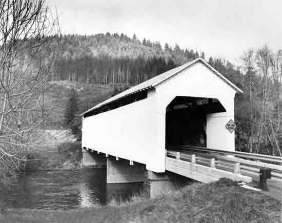 | ||
| Structure Number 39C386 | Constructed - 1928 | |
| Nelson Mountain County Road 3640 | Timber Through Truss (Howe) Covered Bridge | |
| Greenleaf vicinity, Lane County | Ownership - Lane County | |
|
LAKE CREEK (NELSON MOUNTAIN) BRIDGE Like other bridges in Oregon, this one has several names. Lake Creek refers to the stream that flows under the bridge, while Nelson Mountain refers to the roadway name and nearby geographic feature. Nelson was also the name of a small United States Forest Service camp in the vicinity of the bridge many years ago. Constructed in 1928, the structure contains a 105-foot housed Howe truss. Like many covered bridges, both the upper and lower chords are one-piece old-growth timbers. The window openings are narrow ribbons at the eaves. The portals are truncated rectangular arches. Decorative, solid S-curve brackets carry the eaves at the bridge ends. In 1984, new reinforced concrete abutments, a support bent, and flooring were added to the structure to increase the load capacity of the structure. | ||
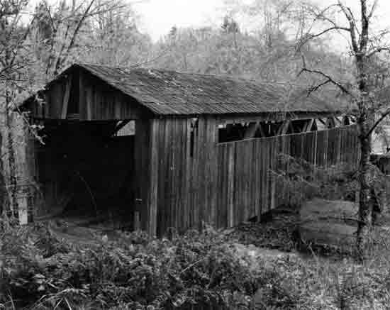 | ||
| Structure Unnumbered | Constructed - 1929 | |
| Private Road off the Umpqua Highway 45 | Timber Through Truss (Howe) Covered Bridge | |
| Drain vicinity, Douglas County | Ownership - Private | |
|
ELK CREEK (ROARING CAMP) BRIDGE Built in 1929, the Roaring Camp Bridge serves several residents on a private road near Drain. The housed Howe truss is 88 feet long. The bridge is unpainted and clad with 1x6" vertical boards. Ribbon openings run the full length of the upper side walls. The bridge was built by Robert Lancaster. Roaring Camp was a roadhouse, once located in the vicinity of the bridge. | ||
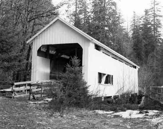 | ||
| Structure Number 16-5E-24 | Constructed - 1930 | |
| Horse Creek County Road | Timber Through Truss (Howe) Covered Bridge | |
| McKenzie Bridge vicinity, Lane County | Ownership - Lane County | |
|
HORSE CREEK BRIDGE The Horse Creek Bridge, constructed in 1930, served vehicular traffic until 1968. The bridge is now bypassed and open to pedestrian use only. The predecessor bridge at this location was a 103-foot covered span, built in 1904. The existing bridge contains a 105-foot housed Howe truss. Like other designs in Lane County, the bridge includes both ribbon openings at the eaves on both sides and a window at eye-level on one side for viewing oncoming traffic. The portals are rectangular-arched. Also, the Lane County characteristic "S-curve brackets" are at the corners of the bridge at the eaves. | ||
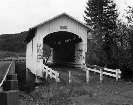 | ||
| Structure Number 39C243 | Constructed - 1930 | |
| Horse Creek County Road | Timber Through Truss (Howe) Covered Bridge | |
| McKenzie Bridge vicinity, Lane County | Ownership - Lane County | |
|
MOSBY CREEK (STEWART) BRIDGE The Stewart Bridge across Mosby Creek is a 60-foot housed Howe truss, constructed in 1930 by Lane County. Because of its deteriorated condition, the covered bridge was bypassed, and a new replacement bridge built. The covered bridge now serves only pedestrian and bicyclist traffic. This short structure has semi-circular portal arches, ribbon openings and decorative S-curve brackets at the eaves on the corners. | ||
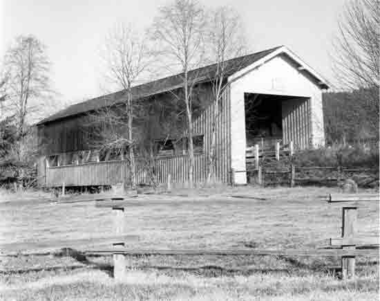 | ||
| Structure Number 12819 | Constructed - 1932 | |
| Halsey-Sweet Home Highway 212, M.P. 12.94 (Bypassed) | Timber Through Truss (Howe) Covered Bridge | |
| Crawfordsville, Linn County | Ownership - Linn County | |
|
CALAPOOIA RIVER (CRAWFORDSVILLE) BRIDGE Originally built by the county in 1932, the 105-foot Crawfordsville Bridge became part of a state highway route and remained in state ownership until bypassed in 1963. The bridge is closed to vehicular traffic, but serves as an historical exhibit-in-place in a Linn County park. The community of Crawfordsville was named for Philemon Crawford, who settled in the area in the 1870s. This Linn County structure displays eye-level ribbon openings, instead of the large exposed truss plan of other bridges common to Linn County. The original semi-circular portal arches were modified to allow larger loads through the bridge. | ||
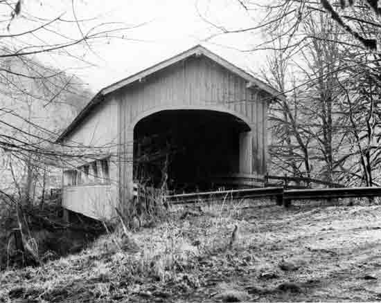 | ||
| Structure Number 16-9W-25 | Constructed - 1932 | |
| Deadwood Loop County Road | Timber Through Truss (Howe) Covered Bridge | |
| Swisshome vicinity, Lane County | Ownership - Lane County | |
|
DEADWOOD CREEK BRIDGE Built in 1932 at a cost of $4,814 by Lane County, the Deadwood Creek Bridge is a 105-foot housed Howe truss. The bridge is barricaded and closed to vehicular traffic. Considerable architectural attention has been given to the structure, including false end beams, semi-elliptical portal arches with trim, and large openings along the west elevation. | ||
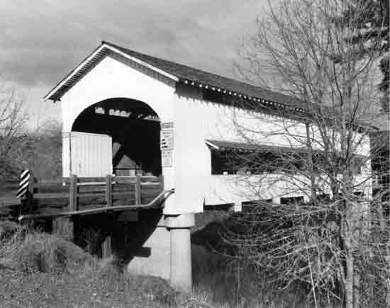 | ||
| Structure Number 14721 | Constructed - 1936 | |
| Jasper-Lowell County Road 6200 | Timber Through Truss (Howe) Covered Bridge | |
| Lowell vicinity, Lane County | Ownership - Lane County | |
|
FALL CREEK (UNITY) BRIDGE The Unity Bridge incorporates a 90-foot housed Howe truss. For the most part, this is the standardized Lane County covered bridge design—semi-elliptical portal arches, ribbon openings at the eaves, and ornate brackets at the corners. This bridge does, however, have a full length window on the east side to give motorists a glimpse of oncoming traffic. The eye-level opening is protected by a small projecting roof. | ||
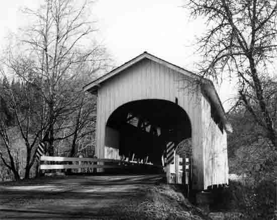 | ||
| Structure Number 1441 | Constructed - 1936 | |
| Harris County Road | Timber Through Truss (Howe) Covered Bridge | |
| Wren vicinity, Benton County | Ownership - Benton County | |
|
MARYS RIVER (HARRIS) BRIDGE Completed in 1936, the Harris Bridge is a housed Howe truss, 75 feet long. The Harris Bridge has semi-elliptical portal arches and ribbon openings under the side wall eaves. The siding is board-and-batten style, and the roof is shingled. The Harris Bridge is one of three remaining covered bridges in Benton County and was named for the nearby community of Harris, established in the 1890s. | ||
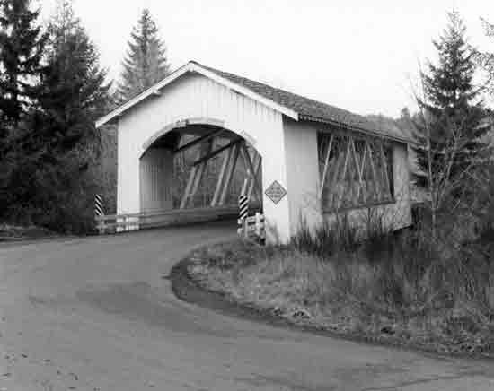 | ||
| Structure Number 12948 | Constructed - 1936 | |
| Camp Morrison Drive County Road 830 | Timber Through Truss (Howe) Covered Bridge | |
| Scio vicinity, Linn County | Ownership - Linn County | |
|
THOMAS CREEK (HANNAH) BRIDGE The Hannah Bridge is the youngest of the five covered spans on Thomas Creek in Linn County. The 105-foot housed Howe truss is exposed through the large side openings of the bridge. Very attractive in appearance, the characteristic Linn County covered bridge design includes segmental portal arches, exposed beams at the gable ends, and white board-and-batten cladding. Thomas Creek was named for Frederick Thomas, who obtained a donation land claim on the banks of the stream in 1846. The Thomas Creek (Jordan) Bridge is located two miles east of the Hannah Bridge. | ||
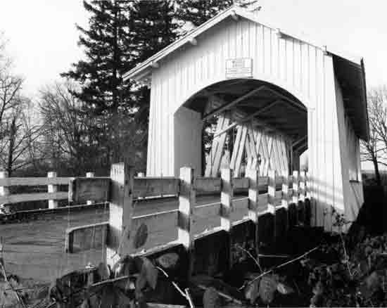 | ||
| Structure Number 12935 | Constructed - 1937 | |
| Kelly County Road 622 | Timber Through Truss (Howe) Covered Bridge | |
| Crabtree vicinity, Linn County | Ownership - Linn County | |
|
THOMAS CREEK (WEDDLE) BRIDGE This bridge goes by two names: Linn County signed the structure "Weddle" Bridge after a nearby farmer, but locals prefer Devaney for another early area resident. This Linn County bridge is closed to vehicular traffic, as a new replacement concrete span was built a quarter-mile away. The old bridge is now used by bicyclists and pedestrians. The housed Howe truss is 120 feet long. The bridge is very similar in design to the other Thomas Creek covered bridges in Linn County. | ||
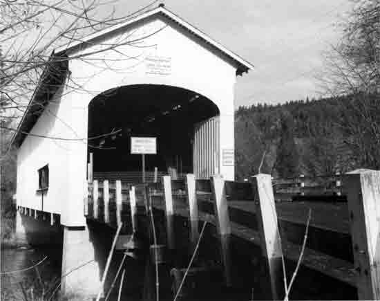 | ||
| Structure Number 18-1W-32 | Constructed - 1938 | |
| Place County Road 6225 | Timber Through Truss (Howe) Covered Bridge | |
| Jasper vicinity, Lane County | Ownership - Lane County | |
|
FALL CREEK (PENGRA) BRIDGE Pengra was a station on the Cascade Line of the Southern Pacific Railroad and honors B.J. Pengra, who became General Surveyor of Oregon in 1862. The Pengra Bridge replaced an earlier housed Howe truss. The bridge contains two of the longest timbers ever cut for a bridge in Oregon. Timbers for the single-piece lower chords, measuring 16"x18"x126', were rough-hewn in the woods and finished at the bridge site. The bridge has semi-elliptical arched portals, ribbon openings on the sides, and an eye-level window on one side. The Pengra Bridge is closed to all traffic. | ||
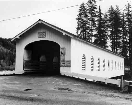 | ||
| Structure Number 39C118 | Constructed - 1938 | |
| Goodpasture County Road | Timber Through Truss (Howe) Covered Bridge | |
| Vida vicinity, Lane County | Ownership - Lane County | |
|
McKENZIE RIVER (GOODPASTURE) BRIDGE One of the most beautiful and photographed covered bridges in Oregon, the Goodpasture Bridge is a popular representative of Oregon's covered bridge heritage. Its location near State Route 126 makes it one of the most visible covered bridges in the state. The bridge was built by Lane County for a cost of $13,000. A.C. Striker was the local county bridge superintendent. Lane County utilized a State Highway Department standardized bridge design. The structure has superb architectural detailing, including ten gothic style louvered windows on each side. Other details include the false end beams and semi-elliptical portal arches. The structure is a 165-foot housed Howe truss. The bridge is named for a pioneer family who settled nearby. | ||
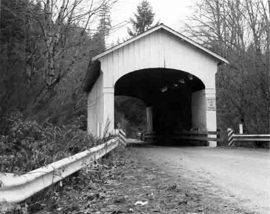 | ||
| Structure Number 39C174 | Constructed - 1938 | |
| Wendling County Road | Timber Through Truss (Howe) Covered Bridge | |
| Marcola vicinity, Lane County | Ownership - Lane County | |
|
MILL CREEK (WENDLING) BRIDGE The Wendling Bridge is one of four covered bridges built in 1938 by Lane County. The others are the Pengra, Goodpasture and Ernest bridges. A 60-foot housed Howe truss, the Wendling Bridge was named for George X. Wendling, director of the Booth-Kelly Lumber Company, who established a post office in the 1890s in the small town nearby. Lane County spent only $2,241 to build the bridge, and A.C. Striker was the Lane County bridge superintendent at the time. Architectural treatments include the semi-elliptical portal arches, portal trim boards, and ribbon openings at the eaves. | ||
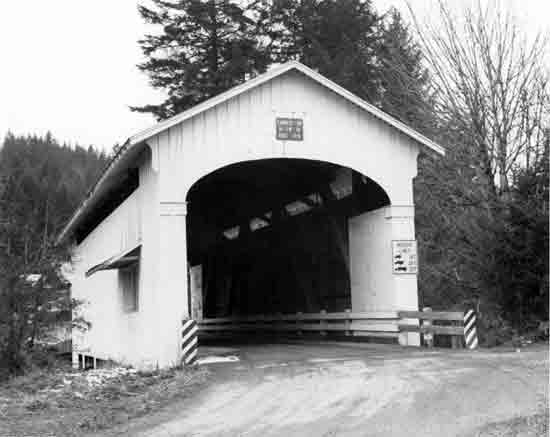 | ||
| Structure Number 39C176 | Constructed - 1938 | |
| Paschelke County Road 1980 | Timber Through Truss (Howe) Covered Bridge | |
| Marcola vicinity, Lane County | Ownership - Lane County | |
|
MOHAWK RIVER (ERNEST) BRIDGE The original covered span at this location was erected in 1903 by A. C. Striker and was called the Adams Bridge. Named for another longtime local resident, the 1938 replacement bridge contains a 75-foot housed Howe truss. The bridge is freshly painted and appears to be in good condition. Another standard Lane County design, a distinctive feature of the Ernest Bridge is the small, hooded opening on one elevation of the bridge for motorist visibility. | ||
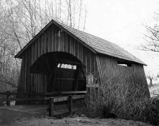 | ||
| Structure Number 12037 | Constructed - 1938 | |
| North Fork Yachats River County Road | Timber Through Truss (Queenpost) Covered Bridge | |
| Yachats vicinity, Lincoln County | Ownership - Lincoln County | |
|
NORTH FORK YACHATS RIVER BRIDGE This bridge is one of the shortest covered bridges in the state at only 42 feet long. Built in 1938, it was the last covered span constructed by veteran bridge builder Otis Hamer. This span is one of four remaining covered bridges in Lincoln County, and only this bridge and the restored Chitwood Bridge are open to vehicular traffic. The flared sides of the Lincoln County covered bridges result from the enclosed buttresses. The arched portals and short ribbon openings under the eaves provide interior illumination. | ||
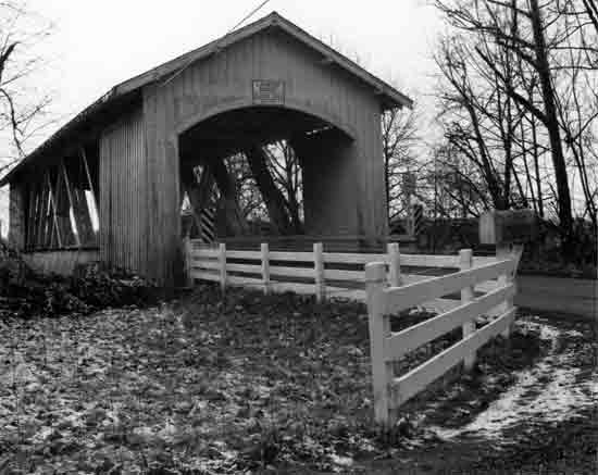 | ||
| Structure Number 12876 | Constructed - 1939 | |
| Fish Hatchery Drive County Road 648 | Timber Through Truss (Howe) Covered Bridge | |
| Crabtree vicinity, Linn County | Ownership - Linn County | |
|
CRAB TREE CREEK (LARWOOD) BRIDGE Located at the confluence of Roaring River and Crabtree Creek, the Larwood Bridge carries the historical name of the community. William T. Larwood opened the post office at a site in the vicinity of the bridge in 1893. The Larwood Bridge is one of three covered bridges across the Crabtree Creek in Linn County. The 105-foot housed Howe truss exhibits the common Linn County design of exposed truss side openings. The bridge is open to vehicular traffic and is adjacent to the Larwood Wayside Park. | ||
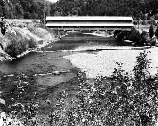 | ||
| Structure Unnumbered | Constructed - 1944 | |
| Private Road | Timber Through Truss (Howe) Covered Bridge | |
| Westfir vicinity, Lane County | Ownership - Private | |
|
NORTH FORK MIDDLE FORK WILLAMETTE RIVER (OFFICE) BRIDGE The most massive and longest of Oregon's covered bridges, this 180-foot housed Howe truss was constructed by the Westfir Lumber Company using triple timber beams to afford the strength necessary to carry heavy logging trucks. The bridge connects the lumber mill with the office (hence the common name of the bridge). The structure is one of only two covered bridges in Oregon built with triple truss members. A distinction of the bridge is the covered walkway on the side of the bridge, separate from the roadway. Westfir was established in 1923 as a company town by the Western Lumber Company. The privately-owned bridge is closed to public traffic. | ||
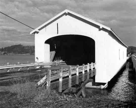 | ||
| Structure Number 19-1W-23 | Constructed - 1945 | |
| Jasper-Lowell County Road (Bypassed) | Timber Through Truss (Howe) Covered Bridge | |
| Lowell vicinity, Lane County | Ownership - Lane County | |
|
MIDDLE FORK WILLAMETTE RIVER (LOWELL) BRIDGE Bypassed in 1980, the Lowell Bridge is the only covered bridge in Oregon spanning a portion of a reservoir. Built in 1945, the Lowell Bridge was raised six feet and the roadway rebuilt in 1953 in anticipation of the pool formed between Dexter Dam and Lookout Point Dam. This is the second covered bridge at Lowell. Its predecessor was a Nels Roney-built bridge constructed in 1907. The current Lowell Covered Bridge is a housed Howe truss, 165 feet in length. The generous width of the bridge allows a roadway of 24 feet and is typical of covered bridges built in the 1940s and after. Distinctive features are the false end beams, semi-elliptical portal arches and two arched openings on the east elevation. The bridge is closed to vehicular traffic. | ||
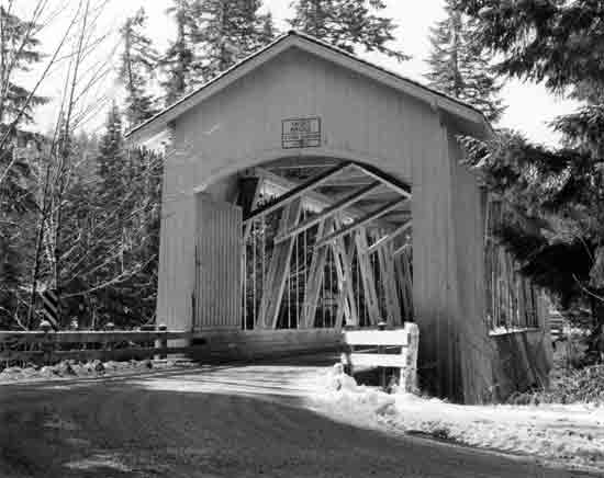 | ||
| Structure Number 14025 | Constructed - 1945 | |
| High Deck County Road 913 | Timber Through Truss (Howe) Covered Bridge | |
| Cascadia, Linn County | Ownership - Linn County | |
|
SOUTH FORK SANTIAM RIVER (SHORT) BRIDGE Originally named for the nearby topographic feature, Whiskey Butte, the bridge was later named for long-term area resident, Gordon Short. The housed Howe truss is 105 feet in length and has the distinctive open feeling of most of Linn County's covered bridges. The open truss provides increased height visibility to the traveler and keeps wind resistance to a minimum. Familiar design features also include segmental portal arches, exposed gable end beams, and white board-and-batten siding. | ||
 | ||
| Structure Number 21-2W-24A | Constructed - 1949 | |
| Government County Road 2440 | Timber Through Truss (Howe) Covered Bridge | |
| Dorena vicinity, Lane County | Ownership - Lane County | |
|
ROW RIVER (DORENA) BRIDGE The Dorena Bridge spans the Row River beyond the upper end of the Dorena Reservoir. The 105-foot housed Howe truss structure was built in 1949, in conjunction with the completion of Dorena Dam. The original townsite of Dorena, established at the turn of the century, was inundated by the waters of the reservoir. The bridge is also referred to as the Star Bridge because of its proximity to the Star Ranch, once a large Lane County private estate. The bridge was bypassed in 1974 and is closed to vehicular traffic. Design features include false end beams, rectangular portal arches, and ribbon openings at the roof line. | ||
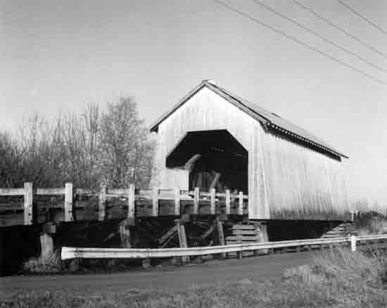 | ||
| Structure Number 45005-17 | Constructed - 1954 | |
| Irish Bend County Road (Bypassed) | Timber Through Truss (Howe) Covered Bridge | |
| Monroe vicinity, Benton County | Ownership - Benton County | |
|
WILLAMETTE SLOUGH (IRISH BEND) BRIDGE The 1954-constructed Irish Bend Bridge is barricaded and bypassed. A replacement structure is adjacent to the covered bridge and provides service to the farms in the area. The covered bridge is a 60-foot housed Howe truss. The portals are truncated rectangular arches, and there are ribbon openings under the side wall eaves. The span has long, trestled approaches. The bridge was built by Benton County and is a plan from the 1920s. Benton County has tried unsuccessfully to find a new owner to relocate and repair the bridge. | ||
 | ||
| Structure Unnumbered | Constructed - 1962 | |
| Milo Academy Private Road | Steel Through Girder Covered Bridge | |
| Days Creek vicinity, Douglas County | Ownership - Private | |
|
SOUTH UMPQUA RIVER (MILO ACADEMY) BRIDGE The Milo Academy Bridge is the replacement for a covered timber structure erected at this location in 1920. The present 100-foot steel through plate girder span, constructed in 1962, was housed in response to requests from local residents to recreate the effect of the original covered span. The Milo Academy Bridge is one of only two covered bridges in the Oregon Covered Bridges Thematic Group which do not have a timber truss support. The bridge has rectangular portals and formally-placed rectangular side openings. The roof is metal, and the bridge is clad with vertical wood siding. Milo was established as a post office in 1923 and was named after Milo, Maine. The private bridge provides access to a Seventh Day Adventist school. | ||
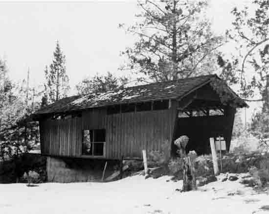 | ||
| Structure Unnumbered | Constructed - 1963 | |
| Bowery Lane Private Road | Timber Deck Girder Covered Bridge | |
| Bend vicinity, Deschutes County | Ownership - Private | |
|
SWALLEY CANAL (ROCK O' THE RANGE) BRIDGE The Rock O' the Range Bridge is the only covered bridge in eastern Oregon and is a recently constructed one. Although constructed of wood, it is not supported by a truss. Instead, it is a housing on a timber deck girder structure. The bridge was built for a private subdivision by Maurice Olson, a local contractor. It is an architecturally interesting structure, even though its design lacks a historic tradition in Oregon. | ||
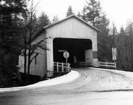 | ||
| Structure Number 39C123 | Constructed - 1966 | |
| King Road West County Road | Timber Through Truss (Howe) Covered Bridge | |
| Rainbow, Lane County | Ownership - Lane County | |
|
McKENZIE RIVER (BELKNAP) BRIDGE Although the Belknap Bridge is the youngest bridge (1966) in the Oregon Covered Bridges Thematic Group, it succeeds three earlier covered spans at this location - Previous bridges were constructed in 1890, 1911, and 1938. The existing bridge was designed by the Oregon Bridge Engineering Corporation (OBEC), Eugene, for Lane County. Louvered arch windows were added in 1975 to the south side to give interior illumination. The portals are rectangular-arched. The name Belknap refers to early pioneers along the McKenzie River. R.S. Belknap developed Belknap Springs, while his son J.H. Belknap had an interest in the toll road that was built over McKenzie Pass in the early 1870s. | ||
OTHER HISTORIC BRIDGES
Nine highway bridges in Oregon have been individually recognized as historically significant. Six of the bridges have been formally determined eligible for the National Register, while the other three are listed on the National Register. With the exception of the two Columbia River crossings, Interstate Northbound Bridge (1917) and Lewis and Clark Bridge (1930), each of these bridges received their National Register status by separate actions.
The ODOT, acting through the Federal Highway Administration, requested National Register eligibility status on the following four bridges proposed for modification or replacement: Willamette River (Steel), Oswego Creek, Alsea Bay (Waldport), and Thomas Creek (Jordan). Two federal agencies requested historic opinions on highway bridges for planning purposes: United States Soil Conservation Service, Rock Creek (Olex) Bridge; and United States Forest Service, North Umpqua River (Mott) Bridge.
The S.W. Vista Avenue Viaduct, a 1926 reinforced concrete arch structure in Portland, was listed on the National Register in April 1984. That nomination was sponsored by a volunteer group of concerned residents, the Vista Bridge Light Brigade.
The two Columbia River bridges, Interstate Northbound and Lewis and Clark, were inventoried and evaluated for historic significance in conjunction with the Washington historic bridges survey. The Washington survey was conducted by the State Office of Archeology and Historic Preservation, in cooperation with the Washington State Department of Transportation and the Historic American Engineering Record. That survey concluded in a thematic National Register nomination, "Historic Bridges/Tunnels in Washington State," which included the two structures adjoining Oregon and Washington. The bridges were listed on the National Register in July 1982.
The nine bridges are summarized below and shown on the following photo-description pages.
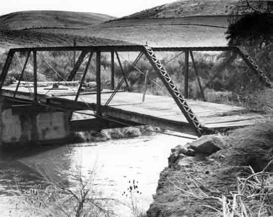 | |||||
| Structure Unnumbered | Constructed - Ca. 1905 | ||||
| Private Road | Steel Pony Truss (Half-Hip Pratt) | ||||
| Olex vicinity, Gilliam County | Ownership - Private | ||||
ROCK CREEK (OLEX) BRIDGE This pony truss was built by the Pacific Iron Works of Portland to replace an earlier timber bridge and is one of only three known examples of the half-hip Pratt truss in Oregon. The truss members are pin connected. In proximity to the bridge are the Olex School (1903), Crum Gristmill (1883), and an old wagon road. The Rock Creek Bridge was built about 1905, based on available records. The bridge was determined eligible for the National Register in November 1975. | |||||
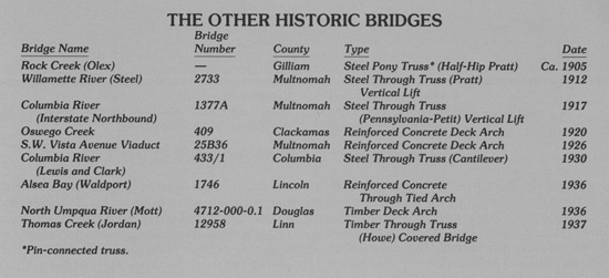
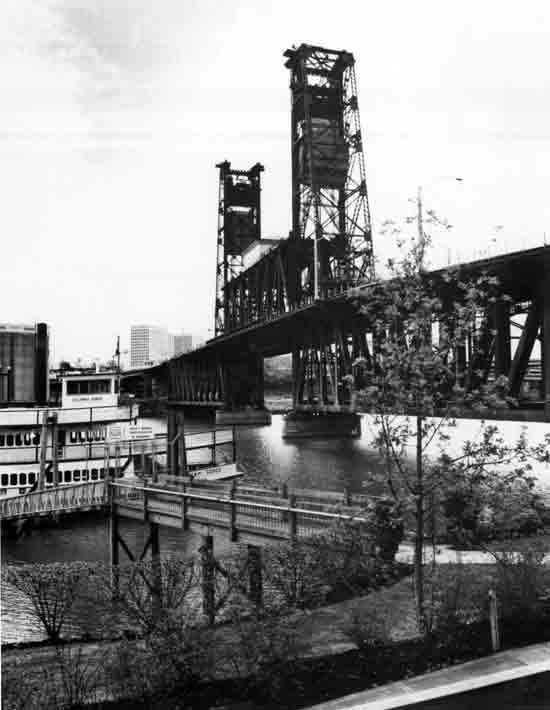 | ||
| Structure Number 2733 | Constructed - 1912 | |
| Pacific Highway West 1W, M.P. 0.36 | Steel Through Truss (Pratt) Vertical Lift | |
| Portland, Multnomah County | Ownership - Union Pacific and Southern Pacific railroads | |
|
WILLAMETTE RIVER (STEEL) BRIDGE Built jointly by the Oregon Railway and Navigation Company and the Union Pacific Railroad, the Steel Bridge was the largest telescoping bridge in the world at the time of its opening. The telescoping function of the central span, a 211-foot steel, through Pratt truss, double vertical lift span, makes the Steel Bridge an important example of a rare engineering design. The lower railway deck can be raised for the passage of small vessels without disturbing automobile traffic on the upper deck. For larger vessels, both spans can be raised. It is believed to be the world's only double-lift span that can raise its lower deck independently of the upper deck. Opening both decks allows for 163 feet total clearance. The bridge was designed by Waddell and Harrington, consulting engineers from Kansas City, and the railroad engineers. The bridge was built over a two-year period at a cost of $1.7 million. There are two secondary steel through Pratt truss spans, each 290 feet long. The structure has little decorative embellishment, other than a wrought iron woven lattice railing. This structure is located near the site of the first Steel Bridge (1888). The 1912 structure was determined eligible for the National Register in April 1980. | ||
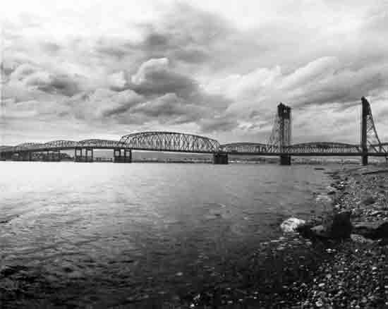 | ||
| Structure Number 1377A | Constructed - 1917 | |
| Pacific Highway 1 (I-5), M.P. 308.38 | Steel Through Truss (Pennsylvania-Petit) Vertical Lift | |
| Portland vicinity, Multnomah County (Oregon) and Vancouver, Clark County (Washington) | Ownership - State of Oregon | |
|
COLUMBIA RIVER (INTERSTATE NORTHBOUND) BRIDGE This structure, listed on the National Register in July 1982, was a major engineering and financial accomplishment, being the first highway bridge across the Columbia River to connect Oregon and Washington. The bridge was designed by Harrington, Howard, and Ash, a Kansas City engineering firm, and was constructed for a cost of $1,683,000. The main span is a 279-foot steel through truss vertical lift span of the Pennsylvania-Petit type. There are ten steel through Pennsylvania truss secondary spans, ranging in length from 266 to 531 feet, providing a total structure length of 3,538 feet. The matching parallel bridge structure immediately to the west (downstream) of the 1917 bridge was constructed in 1958. | ||
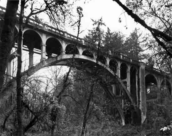 | ||
| Structure Number 409 | Constructed - 1920 | |
| Oswego Highway 3, M.P. 6.76 | Reinforced Concrete Deck Arch | |
| Lake Oswego, Clackamas County | Ownership - State of Oregon | |
|
OSWEGO CREEK BRIDGE The Oswego Creek Bridge, designed by Conde B. McCullough and built by the Pacific Bridge Company of Portland, was originally known as the Sucker Creek Bridge. Public opinion forced a name change in the creek, and hence the present name of the bridge. The bridge is a local landmark and has considerable artistic treatment. Because of the structure's prominence on the old Pacific Highway, the design was deliberately made rather pretentious. Two types of cement were used to provide a striking contrast in the surface. The structure is 300 feet long. The main span, 130 feet in length, is a three-radius shaped, open-spandrel rib arch of reinforced concrete. The spandrel columns have semi-circular arch fascia curtain walls, and the railings are a series of small curved arch openings. A major addition to the bridge was completed on the downstream side of the bridge in 1983 to provide additional travel lanes and safer conditions. The structure addition is a prestressed slab span and is sensitive in design to the old arch bridge. (The above view was taken prior to the project addition.) The bridge was determined eligible for the National Register in December 1979. | ||
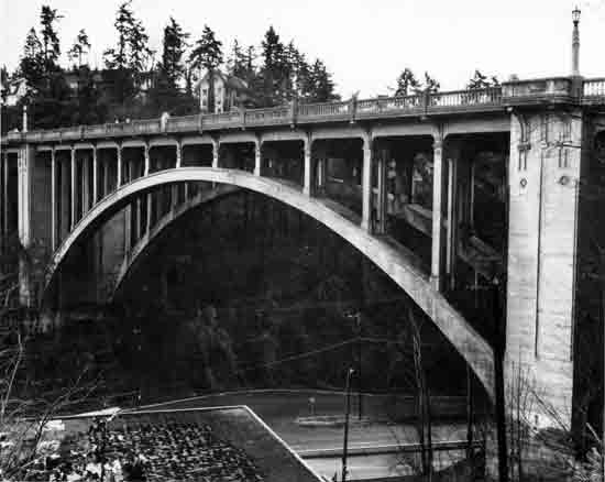 | ||
| Structure Number 25B36 | Constructed - 1926 | |
| S.W. Vista Avenue/S. W. Canyon Boulevard | Reinforced Concrete Deck Arch | |
| Portland, Multnomah County | Ownership - City of Portland | |
|
S.W. VISTA AVENUE VIADUCT The main span of this monumental structure is a 248-foot open-spandrel, rib-type reinforced concrete deck arch. The S.W. Vista Avenue Viaduct is both a highly attractive bridge and a popular local landmark. Great attention was given to decorative detail by its designer, Portland city bridge engineer Fred T. Fowler, evidenced by the ornamental lampposts, pylons, pebble-dashed inset panels, scrollwork, and the spindle-type balustrade railing. Four pedestrian balconies offer vistas of Mt. Hood and downtown Portland. The bridge is a designated Portland Historical Landmark and was listed on the National Register in April 1984. | ||
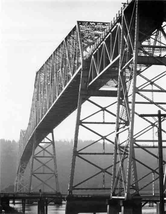 | ||
| Structure Number 433/1 | Constructed - 1930 | |
| Washington State Route 433 at the Lower Columbia River Highway 2W, M.P. 48.92 | Steel Through Truss (Cantilever) | |
| Rainier, Columbia County (Oregon) and Longview, Cowlitz County (Washington) | Ownership - State of Washington | |
|
COLUMBIA RIVER (LEWIS AND CLARK) BRIDGE The Lewis and Clark Bridge is an impressive steel through cantilever truss structure. The entire structure is 1.6 miles in length (8,288 feet) including approaches. The 2,722-foot cantilever truss has a main span which measures 1,200 feet and rises 195 feet above the Columbia River channel. When constructed, it was the longest cantilever span in the United States. The chief designer was Joseph B. Strauss of Chicago, who later designed the Golden Gate Bridge (1937) in San Francisco. The general contractor was the Bethlehem Steel Company. The bridge was privately built by the Columbia River-Longview Company in 1930 and purchased in 1947 by the Washington State Department of Transportation. In July 1980, the bridge was officially renamed the Lewis and Clark Bridge. The bridge was listed on the National Register in July 1982. | ||
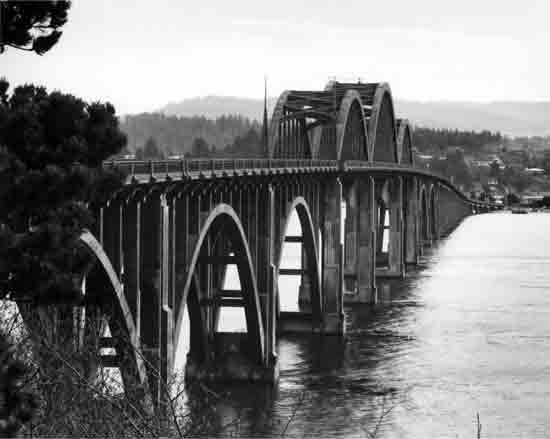 | ||
| Structure Number 1746 | Constructed - 1936 | |
| Oregon Coast Highway 9, M.P. 155.54 | Reinforced Concrete Through Tied Arch | |
| Waldport, Lincoln County | Ownership - State of Oregon | |
|
ALSEA BAY (WALDPORT) BRIDGE The main spans of this 3,011-foot structure are three reinforced concrete through tied arches, 154, 210, and 154 feet in length. Three 150-foot concrete deck arch secondary spans are on either side of the main spans. Thirty-two concrete deck girder approach spans also complement the structure. Decorative features include ornamental railing and spandrel post brackets, fluted entrance pylons, obelisk spires at the arch portals, and a pedestrian observation plaza. Significant for its impressive design and ornate treatment, the bridge was one of five major structures built during Oregon's WPA-financed Coast Bridges project, all designed by Conde B. McCullough, State Bridge Engineer, and completed in 1936. The overall appearance of the Alsea Bay Bridge is one of grace, rhythm, and harmony with the marine setting. The Alsea Bay Bridge is the largest of the reinforced concrete tied-arch bridges by McCullough and is considered by some experts to rank among the finest examples of concrete bridge construction in America. The structure was determined eligible for the National Register in March 1981. The Alsea Bay Bridge is scheduled for displacement, and final planning is underway for the replacement structure. | ||
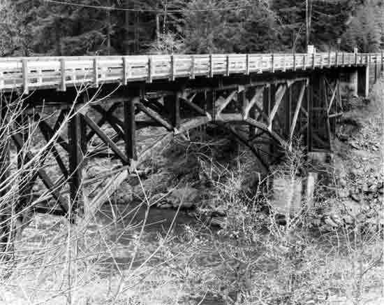 | ||
| Structure Number 4712-000-0.1 | Constructed - 1936 | |
| Steamboat Ranger Station Road | Timber Deck Arch | |
| Steamboat vicinity, Douglas County | Ownership - Umpqua National Forest, United States Forest Service | |
|
NORTH UMPQUA RIVER (MOTT) BRIDGE One of only two known timber deck arches in Oregon, this 135-foot braced-spandrel, three-hinged arch span was constructed by the Civilian Conservation Corps and is a rare bridge type. The bridge was dedicated as the Mott Bridge in honor of nationally-known author and sportsman, Major Mott, who established a fishing camp near the bridge site. The bridge currently provides access to the Steamboat Ranger Station. The bridge was determined eligible for the National Register in November 1980. | ||
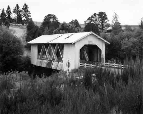 | ||
| Structure Number 12958 | Constructed - 1937 | |
| Jordan County Road 829 | Timber Through Truss (Howe) Covered Bridge | |
| Lyons vicinity, Linn County | Ownership - Linn County | |
|
THOMAS CREEK (JORDAN) BRIDGE A prominant local landmark and an attractive example of covered bridges, the Jordan Bridge is a 90-foot housed Howe truss. The bridge takes its name from the nearby community of Jordan, named for the Jordan Valley in Israel. The Jordan Bridge is one of Linn County's seven distinctive covered bridges with large side openings. The portal arches were originally rounded or segmental, but have been altered to a truncated rectangular shape, expanding clearance for large loads. The bridge was determined eligible for the National Register in February 1984. (The Jordan Bridge is scheduled for displacement in the summer of 1985, and planning is underway to relocate and reconstruct the structure in a park in Stayton, Marion County.) | ||
| <<< Previous | <<< Contents>>> | Next >>> |
sec3.htm
Last Updated: 06-Aug-2008