|
HISTORY OF THE OREGON STATE PARKS: 1917-1963
|
|
Section 2
EARLY DEVELOPMENT
Acquisition
On finding that the 1921 law was not sufficiently broad to cover the needs of land acquisition for parks and in some cases additional strips for the preservation of the scenic beauty along the highways, the Biennial Report of 1923-24, commenting on the legal aspects of land acquisition, states:
". . . the Highway Commission has been embarrassed several times because of a lack of authority to condemn private property for park purposes in conjunction with the improvement and use of public highways. In many instances private parties have offered the funds with which to pay for the private property but have requested and required that the State Highway Commission procure the property by condemnation, the exercise of the right of eminent domain. The Highway Commission has found itself without authority to exercise the right of eminent domain for such purposes, and therefore it would appear good policy for the legislature to confer that additional authority upon the Commission."
The 1925 legislature modified the law. The revised law included in the General Laws of 1925, Chapter 201, states:
"That the state highway commission is hereby authorized and empowered to acquire by purchase, agreement, gift or by the exercise of the power of eminent domain, rights of way, land and ground necessary for the culture of trees and the preservation of scenic places and other objects of attraction and scenic value adjacent to, along or in close proximity to state highways, and said commission is authorized and empowered to acquire, either by agreement, purchase, gift or by the exercise of the power of eminent domain, land and ground necessary for the development and maintenance of parks, parking places, auto camps, camp sites, public squares, recreation grounds or resorts which, in the opinion of the state highway commission, are necessary for the convenience of the public and which are so situated as to be accessible to and conveniently reached by and from state highways.
"The state highway commission is authorized and empowered to acquire, develop, construct, improve and maintain such lands and public places to such an extent and in such manner as will best afford to the traveling public necessary conveniences and accommodations required in connection with the use of public highways to the end that there may be preserved and made available for public use representative stands of virgin timber and other scenic areas valuable for recreational use which are advantageously located along our public highways."
The National Conference on State Parks began to exert an influence on the Commission and the Advisory Committee as indicated in a letter from Charles G. Saurers, Field Secretary, dated November 7, 1927, in which he requested "Consideration in the matter of Pacific Coast States develop and mature a State Park plan which will be a shining example of how it should have been done elsewhere." He also suggested, ". . . amendment in the Federal law which provides for withdrawal by states, counties, and municipalities of portions of unreserved public domain for recreational purposes. It should be amended to include O & C and Coos Bay Wagon Road lands in Oregon." He further states, "With desirable sections of these lands as a nucleus, Oregon could then proceed to gather in ample examples of the finest of her native landscape outside of the National Parks and National Forests." Saurers further states, "Scenery is an unusual natural resource in that it may be used throughout the centuries to come and with proper respect as to fire and mutilization, it still will be there as fine as ever."
Owing to the activity of the Advisory Committee in the period ending in 1926, following the passage of the 1925 legislation, a total of 26 areas were obtained for park purposes. Thirteen of these were donated and 13 were purchased. All were well distributed over the state.
Among the sites donated was a 25 square foot area at Government Camp, summit of the Cascade Mountains, on which the Sons and Daughters of the Oregon Pioneers erected a monument to the memory of Sam Kimbrough Barlow, the pioneer and builder of the toll road from The Dalles to the Willamette Valley in the period 1845-1846. This route furnished a way for the wagon trains to continue westward rather than by raft from The Dalles through the Columbia River Canyon and portaging at Cascade Locks.
A number of the park areas acquired have been important through the years to the people of the state. The viewpoint of the Willamette Falls at Oregon City located between the highway and the railroad immediately opposite the falls is a good example. Access was provided and a monument erected to the memory of John McLoughlin, the Hudson Bay Company Factor, who is referred to as the "Father of Oregon." This monument was erected through the efforts of the Oregon Congress of Parents and Teachers. By contributing 10 cents each, the school children of Oregon raised $1,575, and $425 was raised from other sources. McLoughlin's home in Oregon City is now a National Historical Site known as the "McLoughlin House."
Early in 1922 Sarah Helmick indicated a desire to donate land to the state for park purposes. The land she wished to see developed as a state park lies along the Luckiamute river about six miles south of Monmouth in Polk County. The Commission agreed to accept the gift. The property was conveyed by two deeds dated February 15, 1922. One covers 5.16 acres from Sarah Helmick and the other covers 0.3 of an acre from James and Amanda Helmick. These deeds bear the earliest date of any land acquired by the Commission for park purposes.
The first land purchased for park purposes was Holman Wayside located near the community of Eola in Polk County. It was purchased from Thomas C. and Cora J. Holman at a price of $1,000. The deed is dated April 17, 1922.
The first land acquired by an agreement was Bradley Wayside, also known as Clatsop Crest, in Clatsop County. On March 25, 1922, the Commission agreed to take over the area. The agreement was between the Highway Commission, Clatsop County and the Bradley Estate. It was deeded to the state on April 13, 1932.
I mention, however, that the Highway Commission voted on May 25, 1921, to accept a proposed gift of 260 acres of land at Rowena Loops in Hood River County which Mark A. Mayer proposed to purchase and give to the state for park purposes. Deed covering this area is dated April 12, 1924.
Lands were obtained for Emigrant Springs State Park in Umatilla County, between Pendleton and La Grande, in 1925. This land was eventually to become the most important park on the Oregon Trail.
Land for Humbug Mountain Park in Curry County was obtained by deed dated June 9, 1926, starting one of the finest parks in Curry County.
There were 20 other sites procured or controlled during the early "twenties," a few of which were Cape Sebastian, Harris Beach, Lava River Caves, Viento, Peter Skene Ogden, Boiler Bay and Shelton. All of these areas have served as important links in the chain of parks throughout the state. Some were later enlarged as their use increased and their importance became evident.
In the period following Governor Olcott's administration (1919-1923) there was not a great demand on the part of the political leaders to carry on a highway beautification program or to encourage the advancement of the park plan or idea. However, Highway Commissioners such as William Duby, H. B. Van Duzer and Robert W. Sawyer, and the Advisory Committee on Tree Planting, as well as the Highway Engineers and others were enthusiastic in the advancement of the program, resulting in the rapid increase of the number of sites and the size of each.
Tree planting along the highway in Eastern Oregon continued during the 1923-24 period, furthering the suggestion of many people expressed earlier. This work was done principally along the Oregon Trail between Pendleton and La Grande. A great deal of help was obtained from schools, clubs and Chambers of Commerce throughout the state.
Acquisition of the timber waysides along the Wallowa Lake Highway continued. At the end of 1929 a total of 189 acres had been obtained.
Congress approved a law on June 14, 1926, known as the "Recreational Act," which allowed certain U. S. Department of Interior lands (Bureau of Land Management) to be sold to public agencies for recreation purposes at a price fixed by the Secretary of the Interior. The law has been revised from time to time so that as of 1960 land may be conveyed for park purposes at a rate of not more than six sites, but not to exceed 12,400 acres, in the years 1960, 1961 and 1962. After 1962, three sites and not to exceed 6,400 acres may be obtained in any one year. In addition to the above, small tracts of not more than 10 acres needed for roadside parks and rest sites, may be obtained. Applications not completed may hold over for processing to the extent that the maximum allowable acreage will not be exceeded in the year application was made.
By Executive Order in 1961, BLM lands for recreational use are priced at $2.50 per acre in case of sale and 25 cents per acre if leased. Reverter clauses and all other restrictions in the transfer of title to the state shall cease to be in effect 25 years after the Secretary of the Interior authorizes the transfer.
The revested O & C Railroad Grant lands and the reconveyed Coos Bay Wagon Road Grant lands may be leased at a price fixed by the Secretary of the Interior.
Lands for historic monument purposes may be obtained without monetary consideration.
In the 1925-27 period, acquisitions continued at a reasonably fast pace with the purchase of strips of land of varied width along the highways for the Blue Mountain Forest Wayside on U. S. 30 between Pendleton and La Grande, the Hood River-Mosier section in Hood River County and Rattlesnake Spring in Baker County. Land for Dooley Mountain Wayside was obtained on the Baker-Unity Highway Route 7; also an area was obtained easterly of Middle Bridge on the Baker-Halfway Route 86, and another area six miles east of Unity on Route 26 was secured. The last four of these were acquired for the purpose of furnishing drinking water for the traveler.
Two tracts of federal lands in Curry County were obtained. One is the Ophir Waysides and the other is 290 acres as an addition to Humbug Mountain Park.
In Deschutes County, Pilot Butte Park at the east edge of Bend was donated to the state in 1927 by Kempster B. Miller, Francis R. Welles and Charles A. Brown in honor of Terrence H. Foley, a former resident of Bend. The Robert W. Sawyer Park north of Bend was purchased from the State Land Board. The deed is dated April 28, 1931.
In Douglas County the Camas Mountain Park was leased from the federal government.
One small area in Grant County, known as Johnny Kirk Spring, was given to the state, as was Booth Park in Lake County.
In Lincoln County, Yachats Park at the westerly edge of the town of the same name was obtained from eight different owners. Otter Crest, a small area providing an excellent marine overlook at the highway summit six miles north of Newport, was obtained.
There were three areas enlarged, the Peter Skene Ogden Park in Jefferson County, Chandler Park in Lake County, both as gifts, and the Wallowa Forest Reserve in Wallowa County was enlarged by purchases.
The 1927-28 Biennial Report shows the cost of operation of state parks to the end of 1928 as $109,183, of which amount $28,933 was spent to rebuild the fire-destroyed building at Emigrant Springs. The report also says, "The Commission has taken especial interest in the acquisition of lands bordering the Old Oregon Trail between Deadman's Pass and La Grande with the stand of trees found thereon. These trees give added beauty to the country through which this highway passes and their removal would leave a desolate and unsightly waste. In addition, they make the first forest reached by the tourist from the East, and, after his many miles of travel across the open plains and deserts, they are welcomed as gratefully as they were by the immigrants who used the original Oregon Trail. A strip on each side of the road, varying in width from 130 feet to 1,900 feet, has now been acquired for a distance of 30 miles, assuring the permanent preservation of these trees."
In other parts of the state, logging had been in progress on lands near the highways before any thought had been given to the importance of preserving the trees bordering the rights of way.
Effort was made by the Engineer and the Commission to make exchange of private land for U. S. Forest Service lands along the highways. The idea was eventually abandoned owing to the inability to obtain the proper legislation. In its place the U. S. Forest Service and a few of the timber companies set aside timbered strips along the highways to be preserved for the benefit of the traveler. The U. S. Forest Service had established a policy of preserving a strip on either side of the highways in the forest where no use is permitted. It extends approximately 300 feet from road center. The dead and dying trees were removed annually.
In the case of privately-owned lands where logging had not yet been undertaken, a difficult situation was faced. In many cases the heavy stands of timber were so costly as to preclude the possibility of the purchase of the land and standing timber. In some cases the owners practiced selective cutting. That is, taking out the dead trees and the matured or stagnated trees but leaving a much larger number, which in time gave somewhat the appearance of the original stand. Where cutting had not yet begun, an effort was made to persuade the owner to leave a timbered strip with as little cutting as possible. It was the desire of the Commission to preserve, along the state highway system, typical original stands of the various kinds of trees indigenous to Oregon.
The interest of Dr. John P. Merriam, President of Carnegie Institution of Washington, Washington, D. C., helped in the development of the state park system. Dr. Merriam, who had long been a student of the geological structures and fossil remains of the John Day Valley, called particular attention to the importance of that area for state park purposes. Following his recommendation, the Commission initiated proceedings under the Federal Recreation Act to secure the public land in the John Day Valley suggested by Dr. Merriam as desirable for park purposes.
Scrip was used in the purchase of federal lands when tracts could be obtained at $2.50 per acre. In 1927 application was made for seven 40-acre tracts on the Oregon Trail, the Baker-Unity Highway and on The Dalles-California Highway. Another was made on a 450-acre tract at Humbug Mountain in Curry County, a part of which was expected to be acquired by scrip and the remainder under the Recreational Act of 1926.
Mr. O. A. Prince of Eugene, representing the owners of approximately 100 acres of the Pacific View platted area located south of Yaquina Bay, offered to sell this land to the state for $12,000. This is interesting since the State Parks and Recreation Division is now in the process of purchasing the entire area.
In the period of Mr. Boardman's service as Parks Superintendent from September, 1929 to July, 1950, there were 495 transactions covering 50,842 acres, including 99 gifts of 18,762 acres and 15 leases on 444 acres.
The Commission's interests were broad, however, determined to a great extent by the amount of recreation travel. The most interest was along the Oregon shore, particularly where the roads from the populated areas of the Willamette Valley strike the coast. Interest diminished as the distance increased each way from these points.
Many areas of great value were acquired, particularly in the second and third decades of park activity. Much larger parks were obtained, either in the first acquisition or by additions to existing areas. Also, the public support of the park idea was increasing which gave the Commission a feeling of confidence. This is indicated by the Commission showing less resistance to proposals for park acquisitions.
The matter of acquiring land for parks of larger size from many ownerships proved to be difficult and time consuming. While there were a few condemnation suits in order to purchase lands, a number of settlements were made without resorting to court action even after suits had been ordered.
Acquisition of some of the larger areas, such as Silver Falls Park, required many years. The first acquisition at this park was 90 acres on April 3, 1931. Acquisitions continued through the years, without a lapse of more than two years, until the last purchase in 1952. During that same period the National Park Service purchased 5,730 acres, comprising the area set aside for a youth camp demonstration project. Silver Falls Park now contains 8,059.27 acres. The federal areas were deeded to the state, without cost, in 1947, with a restriction that the land should always be used for park and recreation purposes.
Another large area requiring a great deal of time was South Newport, containing 133 acres with 110 deeds at the close of the year 1962. The first area was acquired in June, 1955. As of January 1, 1963, there were 16 condemnation suits waiting to be tried in the Circuit Court.
Another area which was time consuming in our acquisition was known first as Short Sand Beach but later named Oswald West State Park. A total of 282 acres of land was obtained from 32 owners. The first deed was dated November 12, 1931, and the last was January 12, 1954. One condemnation suit hampered an early closing of the acquisitions. The name of Short Sand Beach Park was changed in 1957 to Oswald West State Park in honor of the former Governor (1911 to 1915). Governor West, by his insistence, obtained a legislative act prohibiting the sale of Oregon's beach land between mean high and low tides and declaring such land a public highway.
Nehalem Bay Park acquisition has also been a time-consuming project. This area included three platted townsites of many ownerships all on the Nehalem Bay Sand Spit. It contains 862 acres with approximately ten miles of bay and ocean shore. Very few trees were on the property because of the nature of the ground, it being barren sand moving with the wind. The first land was obtained in July, 1938 and the last in November, 1961. There were no suits or similar hampering devices. In the main, title to the lands came from the County Court which had obtained the lands through tax foreclosures. Other areas were purchased from individuals. The improvement program at Nehalem Bay, for the past several years, has been only the planting of beach grass and trees as it is believed the greatest need for the area lies in the future. A timbered area adjoining the park on the north is being studied with the thought of acquisition for an overnight campsite.
Some acquisitions involved real problems requiring persistence and patience. A good example is Casey Park. While acquisition began in 1930, title was not acquired until 1937. Complications were encountered principally because of a squatter, J. A. Casey, residing on this federally-owned land. Mr. Casey had constructed a roadside restaurant and a few cabins for which he claimed an investment of $10,000, and the federal authorities insisted that Mr. Casey's claim as "squatter rights" be settled. After considerable negotiation, the government gave the Commission the option of either buying the 80 acres for $275 or leasing it at $13.75 per year. The Commission chose to lease the area and negotiated a lease to Mr. Casey for a period of three years. This arrangement satisfied Mr. Casey. At the expiration of Mr. Casey's lease the Commission chose to purchase the area and title was received in 1937.
There were important gifts such as 125 acres from Mr. and Mrs. Guy W. Talbot at Latourell Falls on the Columbia River Highway. Most of this acreage is on the westerly side of Latourell Creek with only a small part on the easterly side of the spectacular falls. It has an extraordinary stand of natural timber and native plants, and affords superb scenic views of the Columbia River and the north side of the gorge.
An area 23 miles east of Baker was obtained from the federal government in 1930. Another area was purchased in 1931 under the Recreational Act, being 290 acres at Humbug Mountain. Two leases were requested. One was at Wildcat Creek on the Mt. Hood Highway in Clackamas County and the other at Camas Mountain at the summit of the Coast Range on the Coos Bay-Roseburg Highway. Other applications for federal lands were made during this period, 1930-1940.
The year 1930 marks the beginning of a period often referred to as "the depression." The Highway Commission felt the shortage of funds but the bonded debt remained the same. There was much demand for the use of hand labor and the contract method of providing labor was highly emphasized. The income from gas tax and other sources decreased to an alarmingly low point; however, acquisition of park lands continued at a reasonable rate commensurate with available funds. To offset the financial situation, many of the state and federal agencies cooperated in acquisition, construction and improvement of parks.
Parks Engineer Appointed
The appointment of the State Parks Commission marks the end of the activities of the Advisory Committee on State Parks and Recreation. At a meeting August 6-7, 1929, the Highway Commission decided to place Samuel H. Boardman in charge of acquisition of the timbered areas. His title was Parks Engineer and he was to devote his entire time to park matters. This was a move long desired by Commissioner Sawyer who was very much interested in parks and the furtherance of the idea, for which he has, in later years on occasions, been referred to as the "Father of the Oregon State Parks." Selection of Sam Boardman to fill the position was by reason of his profound interest in the tree planting and highway beautification work dating from the beginning of the movement for such planting and highway beautification. His philosophy, as related to parks, as well as his distinguishing characteristics are illustrated in the following quotation from a statement he made soon after appointment:
"The codicil of a legacy that will perpetuate their memories. A monument that will ever brighten in its burnishing. No finer heritage may one bequeath than the natural beauty that springs from the clay from which he cometh and returneth. A continuity of life. Would that such monuments might spire our State. . . Its increased possibilities lie within the wisdom of its people. A magnet that deflects its particles into every thread that spins the spool of Oregon. To cut our way to the land of stumps then we must compute our assets in terms of turpentine. . . The educational and historical side will enter into many of our parks. In the John Day country we are told the rockers are found that cradled the world. Scientists unfold leaf by leaf, strata by strata the geology the paleontology of the beginning of Creation. Unassumingly they take us back ten million years in the chronology of a universe that we now seek to save our flora. Such a shrine of knowledge must be ever left as an open book in the form of a State Park. A state rich in historical lore must have its story told within our parks. Where the speed of the day may halt to pay its homage to a pioneer who yoked his way to blaze a trail we so easily follow today. . . The beautiful myrtle where the mystic touch of nature has trimmed its cultural lines beyond the art of man. And within them all a sense is quickened in the turn of leafy mold that stirs the springtime of our individualities. We live within a heritage beyond our computation. Will we tilt the cup until it runs dry or build for a day beyond our day."
The selection of Mr. Boardman as Engineer of State Parks proved to be a wise choice. In his philosophic way he was influential in persuading many people of means to give property to the state for park purposes. The first ten years of his administration was a period when the economic value of much of the timberlands was in question and the need of such lands for recreational purposes was evident. The combination, with the aid of some persuasion, created an atmosphere in the minds of possible donors wherein the state benefited and the desires of these people were satisfied. Many others offered their lands for parks at a price much lower than could be obtained on the market.
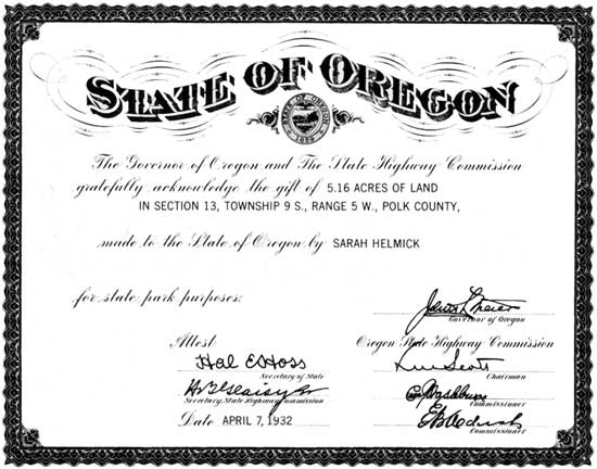
To further the personal interest in gifts, Mr. Boardman suggested and the Highway Commission approved on April 7, 1932, a certificate to be given to donors of park areas or sites. This certificate is as follows:
|
| Acknowledgment of first land donated for state park purposes. |
| <<< Previous | <<< Contents>>> | Next >>> |
sec2.htm
Last Updated: 06-Aug-2008