|
OZARK
A Homeland and A Hinterland: The Current and Jacks Fork Riverways Historic Resource Study |

|
CHAPTER 1:
Prehistoric Presence in the Riverways
Before 12,000 B.C., ancient hunters roamed parts of Missouri in search of the great mastodons and other game. There is very little evidence of human occupation in the Current River basin before the development of the Dalton cultural tradition 4,000 to 5,000 years later (see Table 1). A few signs of the early nomadic Paleo-Indian hunters exists, like the discovery of a Clovis point at the Two Rivers Site. Recent archeological research, however, demonstrates a rich Archaic, Woodland, and Mississippian heritage along the Current River. [1] In fact, a significant body of research has defined an emerging Mississippian culture in the Current River basin and in other sections of the southeast Ozarks centuries before the fullblown development of this cultural tradition in the Mississippi valley. [2]
Table 1
Prehistoric Periods
| Early Man | prior to 12,000 B.C. |
| Paleo-Indian | 12,000 to 8,000 B.C. |
| Dalton | 8,000 to 7,000 B.C. |
| Archaic | 7,000 to 1,000 B.C. |
| Woodland | 1,000 B.C. to A.D. 900 |
| Mississippi | A.D. 900 to 1700 |
Source: Chapman, The Archeology of Missouri, 25. | |
Prehistoric people appeared along the Current in greater numbers after the extinction of the great mammoths and after people began to routinely subsist on foraging for nuts and berries in addition to the old reliance on hunting. A transitional "Dalton" period of approximately one thousand years introduced the transformation in Missouri. The settlement and social patterns of of people in the Dalton era resembled that of the Paleo-Indians. People continued to live in small nomadic bands, consisting most likely of related families, and moved frequently in the quest for food. Yet the Dalton people adapted their method of subsistence to a world without mastodons. Instead of hunting big game, they hunted small animals such as deer, rabbits, squirrels and raccoons. They also gathered wild vegetables and fruits. At Dalton sites, a relative abundance of materials such as mortars, manos, grinding slabs, cupstones and hammerstones suggest a greater dependence on nuts, berries, and other plant food. [3]
Along the Current and Eleven Point rivers, the discovery of serrated knives and Dalton points at several prehistoric sites, including Akers (23SH23), Powder Mill Visitor Center (23SH74), Alley Spring (23SH93), and Jerktail Landing (23SH121) suggests that people of the Dalton tradition inhabited the region. By 7,000 B.C. the inhabitants of southeast Missouri developed a more a sophisticated culture that archeologists identify as the Archaic tradition. [4]
Spanning an estimated six thousand years, the people of the Archaic period introduced more specialized foraging and more complicated social organization. Archeologists divide the period into three phases: the Early Archaic, 7,000-5,000 B.C.; the Middle Archaic, 5,000-3,000 B.C.; and the Late Archaic, 3,000-1,000 B.C. During the early phase, foraging practices supported a semi-nomadic existence with family groups traveling from camp to camp in small defined hunting grounds where they selected campsites based on the seasonal availability of different plant foods. The Early Archaic people also fished and collected shellfish. [5] Changes in material culture distinguished the Middle Archaic phase. Tools and garments, such as small side notched projectile points, grooved axes, and twin fabric sandals, were introduced. [6]
The lifeways of people in the Late Archaic period differed in northern and southern Missouri and illustrated the importance of geography in settlement and subsistence patterns. Climate change, a warm and dry weather trend, spread prairies eastward and into the area now part of northern Missouri. The south, however, remained forested. As a result, in Missouri most of the cultural traits distinguishing the Late Archaic period occurred first north of the Ozarks where people adapted to the changing environment. In the prairies, people settled in larger groups in campsites of one to four acres and developed more complex social organization. They also reduced their emphasis on hunting and turned more to plants, such as roots, the cambium of trees, and prairie potatoes, for sustenance. In the southern forest, the Late Archaic population continued to settle in small groups, and their material culture suggests that animal food remained dominant in their mixed hunting and gathering economy. Small, chipped-stone dart points and plant collecting tools identify the period in the southern Ozarks, [7]
The Current River valley was widely inhabited by Archaic people. These groups as well as later bands of Woodland and Mississippian people commonly settled the terraces above the flood plain of the major streams of the region. For example, prehistoric groups populated Round Spring (23SH19), Akers (23SH23), Owls Bend (23SH10 and 23SH81), Chub Hollow (23CT104), and scores of additional sites for two or more millennia before Europeans entered the Ozarks. Humans occupied the Current riverway throughout these centuries, as their cultural development progressed from one definable stage to the next and, throughout these years, the second and third level terraces remained the best habitation sites. People apparently lived on the lower, first terrace level above the floodplain during the dry years of the Middle Archaic period when the Current shrunk to a fraction of its previous and later size. As a result of the continued settlement of the terrace lands, only a few sites inhabited during the Archaic era had gone unoccupied by later people. One in particular, Logyard (23SH100), displayed "extensive Archaic occupation" through an array of the material culture, including projectile points, bifaces, ground stone, and lithic debris, still present there. Overall, the population of the Current valley greatly expanded during the Late Archaic period. [8]
The next major cultural advance of the people of the Current reflected the Woodland tradition. The territorial border of the Woodland culture primarily stretched east of Missouri to the Atlantic coast and from central Canada to east Texas. Across this vast region, the Woodland era featured increased sedentariness and population density. The central Woodland culture had limited contact with the Current River region. The advent of ceramics, horticulture and an extensive trade network encouraged the centralizing tendencies that predominated in the Early (1,000-500 B.C.) and Middle (500 B.C.-A.D.400) Woodland periods. The appearance of the first ceramics defined the Early Woodland culture and encouraged a sedentary trend since pottery facilitated the storage of food and water and since the "permanent less portable possessions" restricted mobility. In addition, the construction of mounds and earthworks, an illustration of elaborate ritual life," required a sizable labor force and suggested a greater degree of social organization than existed in previous periods. [9]
The Middle Woodland, or Hopewell tradition, had a far reaching cultural influence on North American prehistory. The Hopewell culture developed a trade network that reached west to the Rocky Mountains and south to Florida and the Gulf of Mexico. Along with extensive trading, the major cultural traits that defined the period included farming and large ceremonial earthworks. The Hopewell culture also developed craft specialization and created elaborate ground and chipped stone, ceramic, and copper objects. The Ozark upland was on the periphery of the dominant culture and only some trade goods, small burial mounds, and evidence of small village agriculture reflect a Hopewell influence. [10]
In the Late Woodland phase, the central power of the Hopewell declined while more distinct local cultures increased. This followed a rise in the dependence on agriculture for food and the introduction of the bow and arrow. During the period, Ozark villages grew larger and more isolated, and the inhabitants developed some horticulture. Yet the Ozark people continued primarily to subsist from hunting and gathering throughout the Woodland era. [11]
Woodland people occupied sites up and down the Current and Jacks Fork rivers. They created limestone-tempered cordmarked ceramics and left behind remnants of their pottery at many sites such as Round Spring (23SH70) and the Round Spring Grotto (23SH96), Powder Mill Cave (23SH75), Limekin Hollow Shelter (23SH109), and Akers Ferry (23SH23). As in the early period, many of the Woodland sites were occupied by groups from other periods and, again, this is most common on the terraces above the flood lines. The terrace lands provided easy access to the river throughout human habitation of the Current valley and such places as the Kelley (23CT1), Partney (23CT2), and Campbell (23CT3) farms contain evidence of Archaic, Woodland, and Mississippian occupations. [12]
The rise of the principal Mississippi cultural tradition followed the congregation of people and ideas from a large section of middle America. The complex political organization probably developed at Cahokia and the central Mississippi lowlands; some of the art came from the area of western Tennessee and Alabama; and the region of southeast Missouri contributed shell-tempered ceramics. [13] These people settled in villages along rivers and streams of the Mississippi valley, where they fished, farmed, and hunted. They depended foremost on the cultivation of maize but also raised squash and beans. First refined in central Mexico, these three cultigens were North America's major crop contributions to the world. Deer was the principal animal hunted. Mississippian society established a rigid social order of nobles, commoners, and slaves under the leadership of ruler-priests. Its village communities developed around religious ceremonial centers, such as Cahokia-St. Louis. The preeminence of religion in Mississippian culture is evident in the construction of large mounds as ceremonial temples. These temple mounds and complex ceramics represent the most significant remains of the culture. Mississippian influence declined before the arrival of Europeans. [14]
During the emergence of Mississippian culture, a thriving population resided on the Current River and the eastern Ozarks. These people of the southeast Ozarks appear to have developed two distinct Mississippian characteristics, shell-tempered ceramics and short-stemmed arrow points, approximately 100 to 150 years before these traits spread to Cahokia and to other areas traditionally interpreted as the homeland of the Mississippians. The pottery found at the Owls Bend and the Gooseneck sites indicate the development of these cultural traits beginning around A.D. 700-750 on the Current. This period parallels Naylor and Hayti phases of Mississippi development in southeast Missouri and the Big Lake phase in northeast Arkansas. The shell-tempered ceramics of the Gooseneck site resemble the emergent Mississippian pottery of the Naylor, Hayti, and Big Lake phases. They have recurved rims and no appendages. The Owls Bend group, however, was a different style with flat bottoms and vertical rims. [15]
Along the Current and Eleven Point rivers, archeologists have identified three kinds of Emergent Mississippian sites—ceremonial centers, small villages, and temporary campsites. About thirty miles above the confluence of the Eleven Point and Black Rivers, Pigman mound is the largest ceremonial center. A number of villages once occupied terraces along the Current and some existed by A.D. 700. Sedentary or semi-sedentary in nature, these settlements probably contained, at the most, a dozen dwellings. Small Emergent Mississippian villages were located at Shawnee Creek (23SH11), Round Spring (23SH19), Isaac Kelley (23CT111) and Owls Bend (23SH10), and Gooseneck (23CT54) sites. A Mississippian cemetery at Round Spring, along with shell-tempered ceramics and expanding-stemmed arrow heads, indicates that the area housed a sedentary or semi-sedentary village. Archeologists uncovered evidence of Emergent Mississippian structures at Isaac Kelley and Shawnee Creek. The residents of Shawnee Creek lived in rectangular wall trench houses like those common in the Mississippi River alluvial valley southeast of the Ozarks. At the latter site, two refuse pits contained much cultural material, including shell-tempered and limestone-tempered ceramics. The co-occurence of the two types of ceramics revealed that the early Mississippian group at Shawnee Creek was in contact with the Woodland Meramec Spring people on the upper Current River valley and Salem plateau during the eleventh century A. D. [16]
The Owls Bend site lays on one of the larger terraces along the Current River. Its Emergent Mississippian population manufactured and maintained tools at the site and embellished some of their ceramics with tool or textile impressions. The Gooseneck village site features a midden deposit with animal and plant remains and reflects a very diverse hunting and gathering subsistence pattern. The people of this Emergent Mississippian village, occupied between A.D. 700 and A.D. 1000, took full advantage of the local plants and wildlife. They hunted everything from mammals—like deer, raccoons, and squirrels—to birds, fish, and reptiles. They cultivated small gardens of native plants such as knotweed, maygrass, sunflower, little barley, and sumpweed. Some maize production also supplemented their diet. [17]
Mississippian groups also used alluvial terraces as well as colluvial beaches and caves as temporary campsites. The absence of shell-tempered ceramics at some campsites suggests that they were locations of specialized activity. Occupied in the Mississippian period between A.D. 1000 and A.D. 1350, the Akers Ferry sites' (23SH23 and 23SH22) materials stretch over two small areas and pose a periodic occupation of short duration. During this period the locale appeared to have been something of a periodic Mississippian industrial site used for the processing of foodstuff and raw materials. Few of the hills and hollows beyond the river terraces have been investigated for a Mississippian presence. [18]
In the Ozark Uplands, the contacts between prehistoric groups generally occurred along the river valleys and their drainage basins. As a result, during the Woodland and Mississippian periods, the Caddoan people and their precursors influenced the culture of the southern and western Ozarks; the American Bottom people of the St. Louis area exchanged cultural traits with the population of the northern and northeastern Ozarks; and the prehistoric groups along the Current River basin exhibited cultural habits consistent with the lowland populations of southeast Missouri and northeast Arkansas. The Current River drains into the western lowland of the Mississippi valley and, through the prehistoric times, the populations of the two regions experienced the same cultural stages with similar subsistence patterns and technologies. Recent archeological research consider the Current River Archaic and Early-Middle Woodland populations relatively isolated from people outside of the Ozarks or southeast Missouri. For example, little evidence of a Hopewellian influence in the riverways exists, [19]
Cultural distinctions, however, appeared even within the Current River valley. A technological difference distinguished the Woodland populations of the upper and lower Current River. Woodland people along the Jacks Fork and upper Current made and used limestone tempered ceramic while their contemporaries on the lower Current, below present day Van Buren, produced sand-tempered ceramics. Several stone burial cairns near Pulltite and Akers, on the upper Current, are associated with the former group. In general, the cultural material of the Woodland inhabitants demonstrates their dependence upon local resources. Few trade goods came from outside the region, and it was likely the prehistoric groups from the lowland Mississippi valley sites extracted hematite, galena, rhyolite, and basalt from the Ozarks, The relative isolation of the valley's prehistoric groups declined during the Mississippi period; however, the cultural difference between upper and lower Current River populations continued. [20]
The presence of the two ceramic industries on the Current River at Owls Bend and Goosneck marked separate phases of the development of Mississippian culture that occurred simultaneously and again identified separate cultural traditions on the upper and lower Current. In fact, farther north in the more isolated rough terrain in the upper reaches of the Current, a Woodland culture relying on limestone ceramics continued while the societies down river displayed the Mississippian traits. The people along the Current, however, soon began to leave the riverway. [21]
During the eleventh century, Mississippian cultural groups began abandoning their villages on the Current River, as the population of the Ozark upland shifted to larger settlements in the lowlands of southeast Missouri and northeast Arkansas. Between 1275 and 1400, the Mississippian culture grew and prospered in the central Mississippi alluvial valley. There is very little evidence of the Mississippian people near the Current River after A.D. 1250. The Mississippian inhabitation of the Granite Quarry Cave (23CT36) left evidence of this later stage of occupation. Soon after 1350, almost two hundred years before Hernando De Soto entered northeast Arkansas, the Mississippian culture disappeared from this region. The southeast Missouri and northeast Arkansas Mississippian society probably evolved into the Quapaw nation. Several willow leaf arrowheads found in the Current river basin imply that Native Americans used the area as a hunting ground between 1500 and 1650 when Europeans began exploring North America. [22]
|
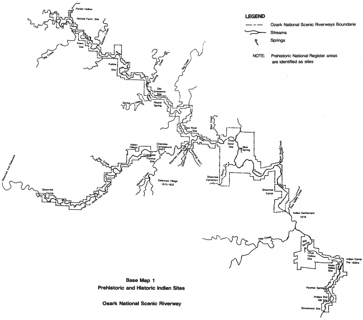
| Base Map 1. Prehistoric and Historic Indian Sites, Ozark National Scenic Riverways. (click on image for an enlargement in a new window) |
NOTES
1Carl Haley Chapman, The Archaeology of Missouri (Columbia: University of Missouri Press, 1975), 25; Mary Lee Douthit, et al., Overview of the Cultural Resources in the Mark Twain National Forest, Missouri, Report to the Forest Supervisor Mark Twain National Forest, Rolla, Missouri, Prepared by the Center for Archaeological Research, Southwest Missouri State University, Springfield, Missouri, 1979; and James E. Price, et al., Archaeological Investigation in the Ozark National Scenic Riverways, 1984-1986, conducted for the National Park Service, Midwest Archeological Center, Lincoln, Nebraska, by the Center for Archaeological Research, Southwest Missouri State University, Springfield, Missouri, 1987.
2Mark Lynott, "Mississippian Archaeology of the Upper Current River, Southeast Missouri," Southeast Missouri Archaeology, 1 (1982): 1-18; Mark Lynott, Susan M. Monk, and James E. Price, "The Owls Bend Site, 23SH10: An Emergent Mississippian Occupation in the Eastern Ozarks, Southeast Missouri," Missouri Archaeological Society Quarterly, 1 (Jan.-March, 1984): 12-14; Mark J. Lynott and James E. Price, Shawnee Creek, An Eleventh Century, Emergent Mississippian Occupation in the Upper Current River Valley, Southeast Missouri, U.S. Department of the Interior, National Park Service, Midwest Archeological Center, Lincoln, Nebraska, 1989; and Mark J. Lynott, An Archeological Evalutation of the Gooseneck and Owls Bend Site: Ozark National Scenic Riverways, Southeast Missouri, U.S. Department of the Interior, National Park Service, Midwest Archeological Center, Lincoln, Nebraska, 1989.
3Chapman, The Archaeology of Missouri, 25; and Douthit, et al., Overview of Cultural Resources, 80-81.
4Douthit, et al., Overview of the Cultural Resources, 83; and Mark J. Lynott, Archeological Survey of Development Areas, Ozark National Scenic Riverway, Midwest Archeological Center, National Park Service, Lincoln, Nebraska, 1981, 111-129.
5Douthit, et al,, Overview of the Cultural Resources, 84-85.
8Price, et al., Archaeological Investigation, 1984-1986, 45-46; Lynott, Archeological Survey of Development Areas, 111-129; and James E. Price and Cynthia R. Price, Interview, January 5, 1989, Naylor, Missouri.
9Douthit, et al., Overview of the Cultural Resources, 95-101.
10Ibid., 97-99. The extent of farming in the Hopewell tradition is not well documented.
11Douthit, et al., Overview of the Cultural Resources, 95, 99-101; and Price, et al., Archaeological Investigations, 1984-1986, 58.
12Lynott, Archeological Survey of Development Areas, 111-129; Mark Lynott, "Mississippian Archaeology of the Upper Current River," 1-18; and Price, et al., Archaeological Investigations, 1984-1986, 50-55.
13Interview with Price and Price.
14Douthit, et al., Overview of the Cultural Resources, 103-105.
15Lynott, "Mississippian Archeology of the Current River," 16-18; Lynott, et al., "The Owls Bend Site," 14, 20; Price, et al., Archeological Investigations, 1984-1986, 43-44, 47, 58; Interview with Price and Price.
16Lynott, "Mississippian Archaeology of the Upper Current River," 10-16; Price, et al., Archaeological Investigations, 1984-1986, 51-55; and Lynott and Price, Shawnee Creek, 29-33. Lynott and Price point out that evidence of only two Mississippian structures of the rectangular wall trench type have been discovered anywhere in the Ozarks.
17Mark J. Lynott, "Mississippian Archaeology of the Upper Current River," 10-16; Price, et al., Archaeological Investigations, 1984-1986, 51-55; Lynott, et al., "The Owls Bend Site," 12-14; Interview with Price and Price; and Lynott, Evaluation of the Gooseneck and Owls Bend Sites, 53-55.
18Ibid.; and Cathy Masters, "Akers Ferry Archeological District," National Register of Historic Places Registration Form, U.S. Department of the Interior, National Park Service, Midwest Archeological Center, 1990, 8-3, 8-4.
19Price, et al., Archaeological Investigations, 1984-1986, 46-47.
20Lynott, Archeological Survey of Development Areas, 82; Price, et al., Archaeological Investigations, 1984-1986, 45-47; and Douthit, et al., Cultural Overview, 102-103.
21Lynott, "Mississippian Archeology of the Current River," 16-18; Lynott, et al., "The Owls Bend Site," 14, 20; Price, et al., Archeological Investigations, 1984-1986, 43-44, 47, 58; Interview with Price and Price.
22Price, et al., Archeological Investigations, 1984-1986, 42-44, 57; Interview with Price and Price.
| <<< Previous | <<< Contents>>> | Next >>> |
ozar/hrs/chap1.htm
Last Updated: 02-Mar-2005