|
National Park Service
A Study of the Park and Recreation Problem of the United States |

|
KENTUCKY
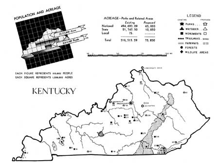
APPROXIMATELY ONE-HALF of the State's people live on farms. Its Negro population, less than 10 percent, is concentrated in its urban districts, in west-central Kentucky and in the Lexington region. The State's principal concentrations of white population are the larger cities along the Ohio River, the southeastern mining section, and the central part of the State around Frankfort and Lexington. The majority of the population is unable to travel very far or pay very much for its recreation.
The mountains of eastern Kentucky offer exceptional opportunities for vacation use. Properly exploited, the scenic and climatic resources of this region should attract tourist and summer vacationists from large sections of the Middle West, middle Atlantic, and the South.
While the State now has a number of State parks, they are, for the most part, located beyond holiday reach of the principal centers of population. There is, therefore, a need for large natural parks near Louisville, Covington, and Ashland. Developments now under way for existing and proposed national parks and forests should largely take care of the additional need for vacation areas in the mountain section. Attention should be given however, to the proper development of all the resources of this region, whether done by public or private funds. Attention should also be given to the clearing up of streams in the State and prevention of pollution of streams flowing out of mining districts. Further efforts should be directed toward preservation of the State's outstanding historic sites.
At least two metropolitan park districts, one for Louisville and environs and the other for Covington, should be established to provide outlying facilities for day use. In the predominantly agricultural sections of the State, numerous small areas are needed to afford recreation for rural people. Areas for Negro use should be established in the vicinity of Louisville, Lexington, and in the west-central section of the State.

(click on image for an enlargement in a new window)
| FEDERAL | ||
| National park: | ||
| 11. Mammoth Cave | 42,631.75 | |
| National historical park: | ||
| 13. Abraham Lincoln | 110.50 | |
| Proposed national historical area: | ||
| 38. Cumberland Gap | 165,000 | |
| National monument project: | ||
| 29. Pioneer | ||
| Proposed national recreational area: | ||
| 37. Cumberland | ||
| Recreational demonstration area: | ||
| 12. Otter Creek | 2,434.84 | |
| National forest: | ||
| 27. Cumberland | 392,771 | |
| Soil Conservation Service: | ||
| 4. Princeton forest preserve | 9,679 | |
| National wildlife area: | ||
| 3. Kentucky woodland wildlife refuge | 47,066 | |
| Proposed national parkway: | ||
| 1. Mississippi River | ||
| STATE | ||
| State parks: | ||
| 2. Columbus-Belmont Battlefield | 400 | |
| 6. Dawson Springs | 457.5 | 50 |
| 7. Audubon Memorial | 486 | 400 |
| 9. Blue and Gray | 87 | 100 |
| 17. Butler Memorial | 340.7 | 200 |
| 26. Cumberland Falls | 593 | |
| 33. Natural Bridge | 1,137 | |
| 34. Levi Jackson Wilderness Road | 382 | 600 |
| 36. Pine Mountain | 2,500 | |
| Total | 6,383.2 | 1,350 |
| Proposed State parks: | ||
| 10. Simpson County | 1,500 | |
| 18. Shelby County | 1,500 | |
| 19. Shelby County | 500 | |
| 28. Madison County | 200 | |
| 41. Carter County | 2,500 | |
| 130. Boone or Kenton County | 2,500 | |
| Total | 8,700 | |
| State monuments: | ||
| 8. Jefferson Davis | 20 | |
| 14. Old Mulkey Meeting House Shrine | 29.8 | 100 |
| 15. My Old Kentucky Home Shrine | 235 | 100 |
| 20. Lincoln Homestead Memorial | 22 | |
| 21. Lincoln Cemetery Monument | 3 | |
| 22. Pioneer Memorial | 18 | 200 |
| 23. Dr. Ephraim McDowell | .5 | |
| 24. Perryville Battlefield Memorial | 17 | |
| 25. Col. Wm. Whitley House | 10 | 100 |
| 32. Blue Licks Battlefield Historic Site | 32 | 300 |
| 35. Dr. Thomas Walker | 12 | |
| Total | 399.3 | 800 |
| State forests: | ||
| 39. Kentucky Ridge2 | 11,701 | |
| 40. Kentenia | 3,264 | |
| Total | 14,965 | |
| LOCAL | ||
| Proposed metropolitan park system: | ||
| 16. Louisville region | ||
| 31. Covington region | ||
| Municipal park: | ||
| 42. Middlesboro | 75 | |
1 Acreage given includes Cumberland Proposed National Historical Area and Cumberland Proposed National Recreational Area.
2 Soil Conservation Service area transferred to the State for administration.
| <<< Previous | <<< Contents>>> | Next >>> |
park-recreation-problem/kentucky.htm
Last Updated: 18-May-2016