|
National Park Service
A Study of the Park and Recreation Problem of the United States |

|
NEW MEXICO
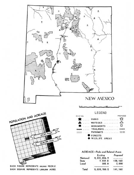
THE POPULATION, which consists principally of three cultural groups, the Indian, the Spanish-American, and the Anglo, is rather evenly distributed over the State, with the bulk of the population found along the rivers, principally the Rio Grande, the Pecos, and the San Juan. With a population density of 3.5 per square mile in 1930, the State has only about one-twelfth the average density of the United States.
The eastern part of the State is largely devoted to dry farming, while large semiarid regions throughout the State, but principally in the central and western portions, are used solely for grazing. The State's largest and most rapidly expanding source of income is the recreation traveler.
From the standpoint of opportunities for outdoor recreation, it is richly endowed, with its wide variety of physical features, diversified climate, lakes and streams stocked with fish, wooded mountains and valleys where hunting is excellent, magnificent stretches of scenic desert, ancient cliff dwellings and Indian pueblos, colorful Spanish-American villages and countless natural scenic attractions.
With the exception of the oil towns in the southwest corner of the State, most of the population centers are fairly well served by State, municipal, and metropolitan parks and nearby national forests, which provide facilities for picnicking, camping, fishing, hunting, and winter sports.
One large reservoir has been developed and another is now being developed for recreational use. Because of the arid character of the State, water is one of the greatest attractions for residents and tourists. Consideration should be given to obtaining the maximum recreation values of water-control reservoirs.
Preservation of the scenic values of the present highways and provision of waysides should encourage a continued increase in tourist travel in the State.

(click on image for an enlargement in a new window)
| FEDERAL | ||
| National parks: | ||
| 57. Carlsbad Caverns | 49,568.4 | |
| National monuments: | ||
| 7. Aztec Ruins | 26 | |
| 8. Chaco Canyon | 21,509.4 | |
| 11. El Morro | 240 | |
| 13. Gila Cliff Dwellings | 160 | |
| 29. White Sands | 143,227.5 | |
| 33. Bandelier | 26,026.2 | |
| 38. Gran Quivira | 611 | |
| 63. Capulin Mountain | 680.4 | |
| Total | 192,480.5 | |
| National forests: | ||
| 1. Coronado | 124,988 | |
| 2. Gila | 2,393,752 | |
| 3. Apache | 889,657 | |
| 9. Cibola | 1,641,828 | |
| 16. Carson | 1,128,481 | |
| 18. Santa Fe | 1,233,678 | |
| 39. Lincoln | 1,145,902 | |
| Total | 18,558,286 | |
| National wildlife areas: | ||
| 24. Bosque del Apache Migratory Waterfowl Refuge | 52,843 | |
| 26. Rio Grande Wildlife Refuge | 73,228.3 | |
| 54. Bitter Lakes Waterfowl Refuge | 14,549 | |
| 56. Carlsbad Bird Refuge | 18,080 | |
| Total | 158,700.3 | |
| Bureau of Reclamation area: | ||
| 27. Elephant Butte Lake | 271,801 | |
| Soil Conservation Service land development project: | ||
| 62. Mills Project | 1,000 | |
| STATE | ||
| State parks: | ||
| 10. Bluewater Lake | 160 | 5,160 |
| 34. Santa Fe-Hyde | 1,135 | |
| 55. Bottomless Lakes | 1,558 | |
| 59. Eastern New Mexico | 380 | |
| Total | 3,233 | 5,160 |
| Proposed State parks: | ||
| 17. El Vado Dam | 100,000 | |
| 41. Ruidosa | 3,000 | |
| 52. Alamogordo Dam | 11,000 | |
| 61. Conchas Dam | 18,000 | |
| Total | 132,000 | |
| State monuments: | ||
| 20. Jemez | 6 | |
| 21. Coronado | 1,280 | |
| 30. Abo | 20 | |
| 31. Quarai | 15 | |
| 32. Paako | ||
| 37. Gran Quivira | 160 | |
| 40. Lincoln County Court House | ||
| 44. Pecos | 80 | |
| Total | 1,561 | |
| Proposed State monuments: | ||
| 4. Hawikuh | ||
| 12. Ice Caves | ||
| 14. Santa Rita Copper Mines | ||
| 15. Acoma Pueblo | ||
| 19. Jemez Crater | ||
| 22. Puray | ||
| 25. Val Verde Battlefield | ||
| 35. City of Santa Fe | ||
| 36. Glorieta Pass | ||
| 42. San Miguel | ||
| 43. Fort Marcy | ||
| 45. Kit Carson Home | ||
| 47. Elizabethtown | ||
| 49. Maxwell Ranch House | ||
| 50. Wagon Mound | ||
| 53. Fort Summer | ||
| State wildlife area: | ||
| 23. La Joya Game Preserve | 2,758 | |
| Proposed State parkways: | ||
| 65. Raton Pass | 1,000 | |
| LOCAL | ||
| Metropolitan parks: | ||
| 60. Tucumcari | 392 | |
| Proposed metropolitan parks: | ||
| 28. City of Las Cruces | 2,000 | |
| 58. City of Hobbs | 1,000 | |
| Total | 3,000 | |
1 Area under Federal administration June 1938.
2 This acreage included in Rio Grande Wildlife Refuge.
| <<< Previous | <<< Contents>>> | Next >>> |
park-recreation-problem/new_mexico.htm
Last Updated: 18-May-2016