|
Poverty Point National Monument Louisiana |
|
 NPS photo | |
A Rich Culture Flourished 12 Centuries Before Christ
The time was eight centuries after Egyptian slaves dragged huge stones across the desert to build the Great Pyramids. The place was across the globe at a site in what is now northeastern Louisiana. The people were a highly civilized group who left behind for us to share one of the most important archaeological sites in North America.
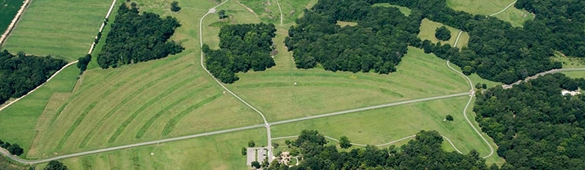
The Poverty Point inhabitants, like the ancient Egyptians, set for themselves an enormous task as they built a complex array of earthen mounds overlooking the Mississippi River flood plain. The central construction consists of six rows of concentric ridges, which at one time were five to ten feet high. The four aisles and five sections of ridges suggest an octagonal shape, although the ridges probably never formed a complete octagon. The diameter of the outer most ridges measures three-quarters of a mile. Bayou Macon, which flows past the site, has eroded some of the original complex. It is thought that these ridges served as foundations for dwellings. Artifacts and features discovered during excavations support this theory.
Nearby are four mounds which are noteworthy for their size and shape. Immediately to the west of the concentric ridges lies Poverty Point Mound, a spectacular bird-shaped mound measuring about 700 by 800 feet at its base and rising about 70 feet into the sky. Motley Mound, a similar construction, is located due north of the central village and is similar in size and shape, although the bird form lacks a tail. North of the Poverty Point Mound is a 20 foot high conical mound called Mound "B". This mound was built over a crematory. The fourth earthen mound, called Lower Jackson Mound, lies about a mile due south of Poverty Point Mound and is similar in shape and size to Mound "B". Neither Motley Mound nor Lower Jackson Mound is on the park site, but both are visible from the highway.
Poverty Point's inhabitants imported certain essential supplies from great distances. Projectile points and other stone tools found at Poverty Point were made from raw materials which originated in the Ohio and Tennessee River Valleys. Soapstone for vessels came from the Appalachian foothills of northern Alabama and Georgia. It is remarkable that these people were able to establish such an extensive trade network so long ago.
To prosper, an ancient culture had to be able to adapt to its environment. One adaptation of the Poverty Point people was made in the field of food preparation. It is known that other peoples at the time used heated stones in earth ovens or hearths as a method of cooking. Since there were no stones at Poverty Point, the people ingeniously molded hard brick-like clay balls for this purpose. Made by hand and hardened by firing, these balls were a perfect substitute for stones. Thousands of the balls, in many shapes and designs, have been found at the site.
Many more fascinating details of the Poverty Point lifestyle are on exhibit for the visitor to enjoy. A large number of beads of various shapes and sizes, including effigies, have been found at the site. These too were probably items of trade. There are also many small stone tools, some with serrated edges, called "microliths", which are unique to this culture.
Poverty Point is indeed a rare remnant of an exceptional culture. It has been estimated that it took some five million man-hours to build the massive earthworks. When one considers that the laborers carried this dirt to the site in baskets of about 50 pound capacity, it is obvious that this was a great community engineering feat. The age, size and character of this collection of structures clearly place them among the most significant finds in America today. Dated between 700 and 1700 B.C., this 400-acre site is unmatched among archaeological sites on this continent. In 1962, Poverty Point was designated as a National Historic Landmark by the U. S. Department of the Interior and, as such, joined a select group of properties which have been recognized for their importance in American History. An interpretive museum and guided tours highlight activities at the park.
Poverty Point State Commemorative Area (HC60, Box 208-A, Epps, Louisiana 71237) is located in West Carroll Parish, east of Monroe on LA 577. The site features ancient Indian mounds which date back to 12 centuries before the birth of Christ. A museum includes an audio-visual presentation and numerous artifacts found on the site. Visitors are taken by tram to the biggest mound and given time to climb to the top. An archaeological workshop, a picnic area and restrooms complete the facility.
Source: Brochure (1984)
|
Establishment Poverty Point National Monument — October 31, 1988 |
For More Information Please Visit The  OFFICIAL NPS WEBSITE |
Documents
National Register of Historic Places Nomination Form
Poverty Point (John W. Griffin, February 28, 1962)
Poverty Point (©Louisiana Division of Archaeology, extract from Discover Archaeology, October 2014)
Poverty Point, A Late Archaic Site in Louisiana Anthropological Papers of the American Museum of Natural History (James A. Ford and Clarence H. Webb, Vol. 46 Part 1, 1956)
Poverty Point: A Terminal Archaic Culture of the Lower Mississippi Valley Louisiana Archaeological Survey and Antiquities Commission Anthropological Study Series No. 7 (Jon L. Gibson, 2nd ed., May 1996)
Poverty Point Expeditions: Activities for Students to Learn about Prehistoric Mound Builders (Deborah Buco, 1999, ©State of Louisiana)
Reconnaissance Report/Study of Alternatives, Poverty Point, Louisiana (February 1988)
The Poverty Point Culture Southeastern Archaeological Conference Bulletin No. 12 (Bettye J. Broyles and Clarence H. Webb, eds., 1970)
popo/index.htm
Last Updated: 01-Jan-2025