|
NATIONAL PARK SERVICE
Great Lakes Shoreline Recreation Area Survey |

|
REMAINING OPPORTUNITIES IN OHIO
|
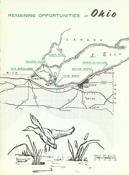
| Remaining Opportunities in Ohio (Vicinity Map) (click on image for an enlargement in a new window) |
SUMMARY
Lake Erie has some unique distinctions among the Great Lakes--distinctions that fashion its character, and create special problems in relation to recreation. It is the southernmost of the Great Lakes, lying entirely below the 43rd parallel. The waters of Lake Erie are the shallowest of the Great Lakes, their maximum depth being 210 feet. The more southerly position of the lake plus the shallowness of its waters combine to make it the warmest of the Great Lakes.
Lake Erie lies in a rich industrial region, and tributary rivers pour into its basin a constant stream of industrial wastes. Lake Erie lies in a rich agricultural region, and tributary rivers pour into its basin a constant load of silt. Lake Erie is shallow, particularly its western end, and wind agitated waves hold the silt in suspension.
The shallow, warm waters encourage the growth of Algae, plankton and bottom organisms, so that only along Erie's shores of the Great Lakes are shells of molluscs common. Lake Erie probably has the greatest amount of fish life on the Great Lakes, both in number of species and individuals. Therefore, it is, to a much greater extent than the other lakes, Everyman's fishing hole where, with a minimum of expense and equipment, a fisherman may feel sure of some luck. Where beaches exist along the shoreline, the shallow, temperate waters add to the swimming appeal.
Over half of the United States shore of Lake Erie lies in Ohio, which, counting islands and Sandusky Bay, amounts to 312 miles. Generally, this shoreline has three facets. From the Michigan line eastward to Vermilion, the landscape is monotonously flat. Rich farmland occupies this former lakebed. Along the shoreline are marshes, usually separated from the lake by narrow barrier beaches. These marshes are of great importance to migrating waterfowl, but with two exceptions these are private lands of hunting clubs. The only break in the continuity of marshy shoreline is the Marblehead Peninsula and the so-called Catawba Island on the north side of Sandusky Bay. The Silurian limestone of this area is also characteristic of the islands of Lake Erie--the second region.
There are four main islands in American waters: Kelleys Island, South Bass, Middle Bass and North Bass Islands. Agriculture, fishing and tourism are their principal economic stays. An island vacation has great appeal, and state parks of sufficient size, stressing camping as a primary feature, could be expected to receive considerable visitation.
From the vicinity of Vermilion to the Pennsylvania line is the shore bluff sector. This segment of Lake Erie compares with the most heavily developed shores on the Great Lakes. A vast complex of marinas, private beaches, exclusive developments, and industrial operations crowd to the edge of the eroding bluffs. Since the natural scene has long been altered, since development is essentially complete, little possibility exists of obtaining natural frontage for public recreation along this section.
Of the five states with more than 100 miles of Great Lakes shoreline, Ohio probably has the greatest degree of lakeside development. There are no extensively forested lands fronting Erie's shores. There are no long, untouched tracts of beach. Farmland, cottage and resort development, industrial frontage, highways and cities have long since appropriated the vast majority of the shoreline. Ohio has a population of over 9,000,000 people, and the need for public recreation areas on Lake Erie is undeniably great.
The State of Ohio maintains 54 areas in its Division of Parks. In addition, the Ohio Department of Highways operates one of the country's outstanding Roadside Park systems. On Lake Erie there are six areas administered by the Division of Parks. One area, Kelleys Island, currently is not developed, leaving five park areas with 2,070 acres of land and 8.9 miles of lake frontage. Perry's Victory and International Peace Memorial National Monument with 20 acres and 3,100 feet of shoreline on South Bass Island is administered by the National Park Service.
Of these, only East Harbor State Park and South Bass Island State Reserve permit camping. However, with the addition of Mentor Marsh to Headlands State Park, the acquisition and conversion of Sandusky's Cedar Point, the consolidation of holdings and development at Crane Creek, Ohio would have six first-rate parks on Lake Erie. These would be parks with sufficient diversity to appeal to a great variety of people: campers, bathers, picnickers, fishermen and nature enthusiasts. Specific recommendations are not made here for any areas in Sandusky Bay, but further study may reveal some possibilities for swimming development. With the addition and improvement of beaches at Geneva-on-the-Lake and Plum Brook, the Division of Parks would have coverage on all but the critical Cleveland area. Even so, the distance from Cleveland to these areas--80 miles at most--is not enough to deter today's highway-oriented vacationists.
A further consideration that would provide benefits for innumerable Ohio citizens would be the extension of the Division of Wildlife holdings on the Ohio Marshlands of western Lake Erie. Provision for public fishing sites on heavily fished portions of Sandusky Bay and elsewhere, while not studied specifically in this Survey, may merit study by the appropriate state organization.
All told, the Ohio study areas recommended in this Survey (exclusive of the Cleveland project) would add 5,772 acres of land and 11 miles of public shoreline frontage. Immediate development of these areas is not necessarily imperative. However, acquisition to provide for future needs of the ever expanding population is important and should not be delayed until existing areas are used to capacity.
| OHIO |
OHIO MARSHLANDS
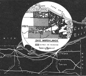
LOCATION The marshes in this report lie between Toledo and Port Clinton on the boundary of Lucas and Ottawa Counties. Metzger Marsh and Magee Marsh, operated by the Ohio State Division of Wildlife, lie on the west and east, respectively. The area comprises 2,195 acres and spans 1.7 miles of shoreline.
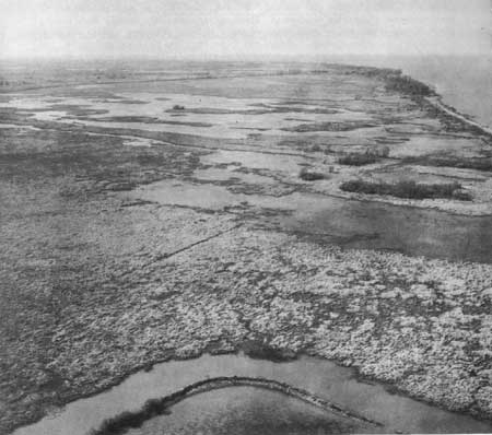
DESCRIPTION Western Lake Erie shores are quite unlike the portions lying east of Vermilion. The region is part of an old lakebed plain without noticeable relief. Shore bluffs are nonexistent; and, commonly, narrow barrier beaches front on marshes of varying width. The region was known as the "Black Swamp" to early Ohioans and was originally largely timbered. Today, nearly all of the timber has been cut and the swamps and marshes drained. Most of the remaining marsh is impractical to farm because of its low elevation and the vagaries of the level of Lake Erie.
Waterfowl from two major flyways pass through the area during migration. Consequently, the marshes are significant resting and refueling stops for ducks and geese. During the breeding season, several species nest in the area. Besides ducks, black terns, herons, coots and other water birds frequent the marsh. Muskrats exist in large numbers.
PRESENT USE Because of their natural importance, plus their proximity to large centers of population--Detroit and Cleveland are both less than 100 miles distant--the marshes on the study area were long ago acquired by private and commercial duck clubs. Most of the land is diked and ditched to control water levels for growth of duck foods. About 700 acres of farmland within the study area are important geese feeding grounds and should be procured by the state for that purpose.
ANALYSIS Because of their position on the flyways, and because of their extent, the Ohio Marshlands comprise the most important waterfowl habitat on the Great Lakes--and are of national significance. The Ohio State Division of Wildlife has undertaken a program of intensive marsh management consisting of control of water levels, growing of desirable waterfowl foods, encouragement of greater local nesting, research investigations in various phases of marsh management and creation of public hunting and refuge areas. In order to consolidate the two areas under their management, to acquire needed agricultural land for production of forage for geese, and to provide for more public hunting facilities, the state needs to acquire the lands included in the study area. The feasibility of a joint state and federal waterfowl project in these highly productive marshlands is being studied.
|
| Ohio Marshlands |
| OHIO |
KELLEYS ISLAND
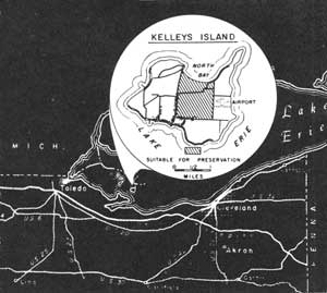
LOCATION Kelleys Island lies 10 miles north of Sandusky in Erie County. Regularly scheduled auto and passenger ferries from Lakeside and Sandusky call on the island during the spring, summer and fall months. Plane flights may be chartered from Peninsular Airport near Port Clinton. The 670-acre study area occupies 1.1 mile of sandy beach on North Bay.
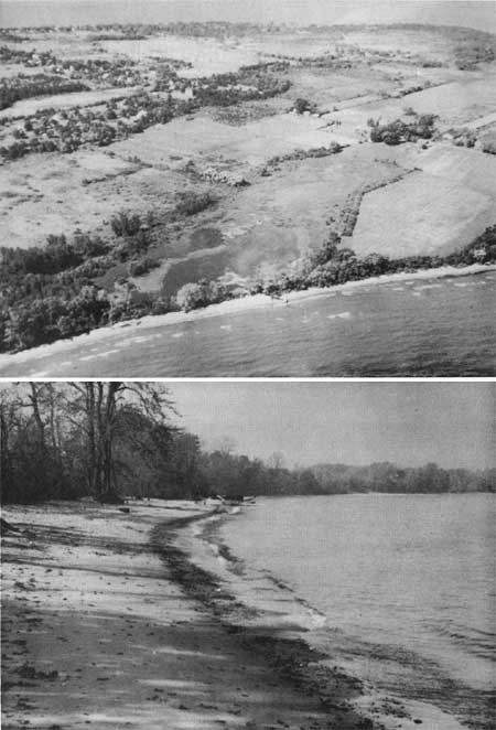
DESCRIPTION Kelleys Island, like the several other islands of the Lake Erie group, is composed of highly fossiliferous limestone. A great variety of invertebrate marine fossils, many of large size, characterizes this rock. The island is about three and one-half miles long by one and three-quarters miles wide with a maximum elevation not in excess of 100 feet. Most of the shores are of shelving rock, shingle beach, or fronted by low cliffs. North Bay, however, has a mile of sand beach of medium width--roughly 50 feet.
The forest cover has long been removed for farming, and rock quarrying has stripped off large areas of topsoil and underlying strata. In quarried areas, small red cedar are the common trees. Elsewhere, almost pure stands of hackberry occur.
On the northeast part of the island are the famous glacier grooves, where overriding glacial ice has worn smooth grooves in the limestone as deeply as three feet. These and a large rock inscribed with Indian petroglyphs are preserved by the Ohio State Archeological and History Society. Another feature of interest is the deserted winery. Built of native stone, this roofless structure is falling in decay as the forest grows up around it.
PRESENT USE Kelleys Island at present has considerable allure for tourists who reach the island by private boat, ferry and plane. Farming, vineyards and quarrying are--or have been--important to the island's economy. Cottontails and pheasants are hunted in season, and the island is a sometimes base for both sport and commercial fishermen. The Ohio Division of Parks owns several hundred acres of land on the island but possesses no desirable beach frontage. No park development currently exists.
ANALYSIS The small pond at the west end of North Bay could be dredged out and expanded to form an excellent, well protected harbor of refuge and large boat camping area. By acquiring the North Bay beach properties and consolidating lands through the center of the island, a highly desirable park could be developed.
|
| Kelleys Island (Ohio Department of Natural Resources photos) |
| OHIO |
CEDAR POINT
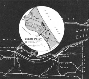
LOCATION The Cedar Point study area includes the whole outer tip of the peninsula that separates Sandusky Bay from Lake Erie. Lying entirely within the city limits of Sandusky, the area is accessible by road over a causeway across the eastern arm of the bay. Included in this study area are 325 acres en compassed by 3.4 miles of shoreline.
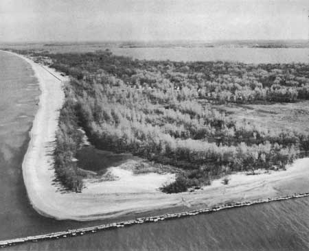
DESCRIPTION Cedar Point is the outer extremity of a sand spit and barrier beach built up by wave action in shallow water. In many places the natural connection with the mainland narrows down to about 100 feet in width, but, at the tip it is nearly 2,000 feet across. Here the Lake Erie side is faced with some of the finest and widest natural sand beaches in Ohio.
The offshore waters are very shallow some 500 feet out from the water line, and the gently sloping beaches (some up to 250 feet in width) are backed up by a band of ten-foot sand dunes. Behind these dunes the terrain is low, heavily wooded and tends to become swamp mixed with mud flats on the Bay side. Cottonwoods and willows predominate in the tree species and are mixed with ailanthus, ash, red and white oaks and a few sycamores. Cattails, sparterdock, iris, jewelweed and wild grape appear in the marshy areas. Poison ivy is fairly prevalent throughout the area.
As along much of the Lake Erie shoreline, snail and two species of clam are abundant. Great blue herons and American egrets occur in the marshes along with the red winged blackbirds, killdeer and gulls that frequent the area. Perch, smelt and sheepshead are plentiful in the surrounding waters.
PRESENT USE A large amusement park has been operating on the study area for many years along with a large, sprawling and antiquated resort. Northwest of the resort much of the area has been subdivided and some new construction has been accomplished. A Coast Guard lifeboat station is located on the western rip of the point. Here, also, are two fishing piers, both of which are badly deteriorated.
ANALYSIS The high quality of the beaches, rare along Lake Erie's shoreline, justify public acquisition of this area to meet growing recreation needs.
|
| Cedar Point |
| OHIO |
PLUM BROOK
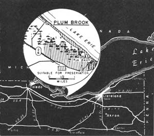
LOCATION Plum Brook lies about 2-1/2 miles northwest of Huron and 6-1/2 miles southwest of Sandusky. It may be reached from Stare Route No. 2 by two roads: one is a locked government road leading to the pumping station on the study area, and the other is a private road. The study area contains 1,400 acres of land, occupying 2.3 miles of shoreline on Lake Erie.
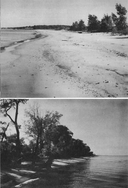
DESCRIPTION The sand spit on which Plum Brook is located terminates at Cedar Point. It is 7.6 miles long and varies from nearly one-half mile to less than 60 feet in width. The Plum Brook segment has approximately 2.3 miles of shoreline divided into three general sections. The north one-fifth is a narrow vegetated strip with small dunes backed by open water. The trees that line this beach are being toppled over by wind and wave and, consequently, litter the beach. The middle two-fifths is free of vegetation, washed over by waves at high water, and is therefore lower and wider. The eastern two-fifths abutts on low farmland, ponds and woodland. Low dunes occur along this stretch and the beach varies greatly in width. Downed trees also line this beach in places.
An inactive government pumping station on the beach once supplied water to a former Army ordinance depot in the vicinity. The open water behind the beach is shallow with a muddy, sparsely vegetated bottom. Marsh exists around the land fingering in from the south. The water areas, periodically drained by the fluctuations of Lake Erie, are favorite feeding places for great blue herons and common egrets, both of which have breeding colonies near by.
PRESENT USE Farming occurs on the lands along the south margin of the study area. A development company has lots for sale along the west end of the barrier beach, but because of the continual erosion and narrowness of the beach, few have been sold. A hunting club owns land on the marshes, and hunting and fishing on other lands doubtlessly occur.
ANALYSIS The land adjoining Lake Erie has a high population and few beaches. Plum Brook represents an opportunity to preserve a 2.3-mile stretch of good sand beach in an undeveloped state. In fact, because of its transient nature, the beach is fit for little else. Development of bathhouse facilities and related structures would be limited to the dry land on the east boundary. The marsh is good wildlife habitat, particularly as a feeding ground for herons, egrets and waterfowl.
|
| Plum Brook |
| OHIO |
CLEVELAND
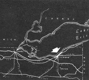
Ohio's Lake Erie shoreline is dominated by the huge metropolitan area centered around Cleveland--the third largest city on the Great Lakes. Together with its highly populated suburbs, this industrial giant covers 44 miles of lake frontage with industry, shipping and residential provisions.
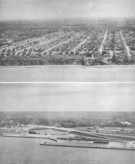
Of these three, residential development consumes the major portion. For mile after mile private homes line the bluffs that rise abruptly 40 to 50 feet from the water's edge. Here, the benefit derived from proximity to the lake is limited primarily to summer breezes and water panoramas. Except during periods of low water, beaches along this section are practically nonexistent, and active water erosion of the bluffs is threatening to undermine some homes near the edge.
Public access to Lake Erie's shoreline is also limited by these factors. Within this metropolitan area, slightly more than ten percent of the shoreline is devoted to park-type use, but bathing beach frontage is less than four percent, providing less than one-tenth of an inch per person living within ten miles of the lake. This situation, of course, is already inadequate to answer present demands for access to this recreation resource along the city's doorstep. Here is a case where natural shoreline is not only "vanishing"--it's already gone!
High real estate values and development along Cleveland's waterfront preclude possibilities for acquisition of additional public frontage. However, another solution to the problem appears to be more feasible. This alternative is based on the construction of a lakeshore drive in front of the shore bluffs, thus reclaiming much of the lake frontage lost through the years of relentless erosion.
From an engineering standpoint, the situation is favorable. The shallow bedrock shelf extending offshore would provide a solid base for construction. With substantial rip-rap along its outer face, backfill could be readily obtained by dredging abundant and suitable clay from the lake bottom. Lying close to the foot of the bluff, the highway traffic would not interfere with vistas from the homes above and the whole project would put an end to the shore erosion problem.
Not only would such a project create a splendid scenic drive along the city's waterfront but, in conjunction, additional public recreation space could be created along with ample, protected beaches. To a city already noted for its Civic Center, Mall and "Emerald Necklace," this would add one of the most attractive waterfronts in the world.
|
| Cleveland |
| OHIO |
MENTOR MARSH
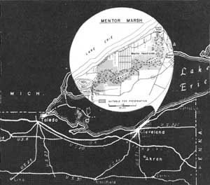
LOCATION Mentor Marsh adjoins Painesville in Lake County and is nearly encircled by several roads. Approximately 1,350 acres of land and 1.6 miles of shoreline are involved. Cleveland, Akron, Canton and Youngstown are within a 75-mile radius.
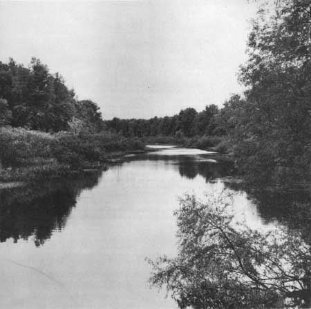
DESCRIPTION Mentor Marsh, a former Channel of the Grand River which now drains into Lake Erie east of the marsh, is three and one-half miles long and averages 2,000 feet in width. It is flanked by gentle slopes topped by flat land. More swamp than marsh, the channel is generally vegetated with elm, ash, silver maple and black willow. The channel slopes and marsh contain about 50 species of deciduous trees of the central forest region, making the area in terms of species the richest encountered on the survey. The commonest and largest species is the red oak, followed by yellow poplar, cucumber tree, hickory and beech.
Wildlife includes raccoon, woodchuck, opossum, cottontail and, probably, fox. Ducks use the marsh during migration and some may nest. Songbirds are common, and the pileolated woodpecker may nest in the swamp. Numerous amphibians and reptiles depend upon the area for their continued existence.
Between the yacht basin and Mentor Headlands is a strip of largely cleared land, 2,000 feet deep with one and one-quarter miles of lake frontage. The beach is narrow to nonexistent, backed by actively eroding shore bluffs, 30 to 40 feet high.
PRESENT USE Most of the marsh is owned by the Morton Salt Company, presumably for the salt deposits which underlie it. No use is currently made of these wetlands, but the lands above the slopes have been largely cleared of timber. Farmland, in places, comes to the edge of the slopes. A golf course lies along part of the south boundary, and the community of Mentor Headlands crowds to the very edge of the marsh.
ANALYSIS Mentor Marsh has great significance as a biological area where many phases of the natural sciences could be studied firsthand. Trails along the slopes and a boardwalk over the marsh would permit access to an environment new to most people. The area's features are enhanced when it is realized that it lies in a region where recreation land is scarce. Camping is feasible along the shore of Lake Erie, and the adjacent Headlands State Park suggests a logical administrative tie-up of the two areas.
|
| Mentor Marsh |
| OHIO |
GENEVA-ON-THE-LAKE
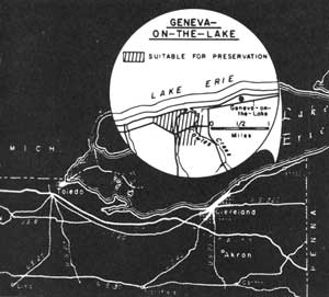
LOCATION Geneva-on-the-Lake is a 244-acre area occupying .9 mile of shoreline on Lake Erie. It lies 5 miles north of Geneva, Ohio in northwestern Ashtabula County on State Route 534. The distances from Cleveland and Youngstown, respectively, are about 40 and 60 miles.
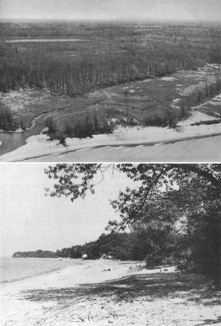
DESCRIPTION The study area is located around the spot where Cowles Creek and a smaller stream to the westward enter Lake Erie through a common outlet. The two streams form a crescent-shaped lagoon immediately behind the shoreline with the horns of the crescent pointing south. The streams are edged by marsh vegetation at this point; the rest of the area is either in forest or has been cleared.
The area is fronted by nearly a mile of beach averaging from 75 to 100 feet wide. It is composed primarily of sand, although some gravel occurs along the water line. Behind the beach, sand banks and low dunes rise about 20 feet.
The woodland bordered by the two streams is primarily composed of red and white oaks with a scattering of beech and other species. Young trees are mainly hickory, which seems to indicate that the stand is arriving at a climax stage of oak and hickory. Most of the trees are large, ranging to 75 feet high, and the understory is open and airy. The soil is well drained and it appears a campground might well be established in such a location without greatly altering the forest cover.
The lagoon, though not deep, could easily be dredged to create a harbor of refuge and public launching site capable of handling a goodly number of boats. A series of such harbors combined with camping areas would serve to meet a growing demand for facilities for these two popular forms of recreation.
PRESENT USE The area is currently used by bathers and fishermen. There appear to be no other important uses, and no structures occur on the study area.
ANALYSIS Geneva-on-the-Lake has a fair beach and could help alleviate the recreation problem for heavily industrialized northeastern Ohio. Development of a harbor of refuge is a possible use with the further possibility of a campground and picnic area in the wooded and cleared portions of the area.
|
| Geneva on the Lake |
| <<< Previous | <<< Contents>>> | Next >>> |
rec_area_survey/gl/oh.htm
Last Updated: 27-Jun-2007