|
Rio Grande
Administrative History |

|
APPENDIX
Additional Impacts and definitions related to the act.
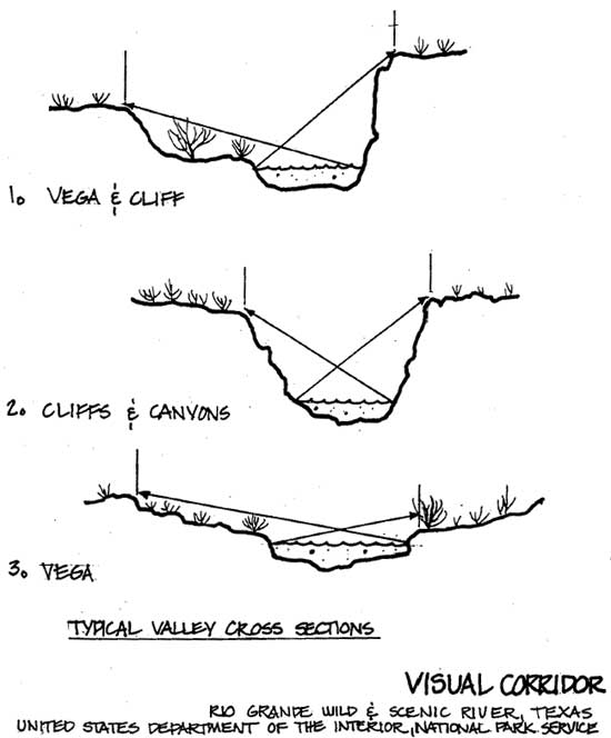
Graphic description of a Visual Corridor.
Bibliography of Recent Rio Grande Wild & Scenic River Studies.
Interested and Involved Persons - Roster & Addresses - 1981
(omitted from the online edition)
Additional Impacts and an Explanation of Certain Terms
Related to the Act
- Landowner Safeguards as Provided in the Federal Act - The clear intent of the Act is to minimize intrusions upon land owners by limiting the amount of land acquisition, particularly in fee, and by limiting use of condemnation. Management needs for land acquisition will be determined by the general management plan.
- Eminent Domain - If more than 50 percent of the land within a designated river corridor is publicly owned - condemnation cannot be used for the purchase of land in fee simple. (Eminent domain can still be used for the purchase of scenic or access easements, however.)
- Fee Simple - is the purchase of a complete package of legal rights. Where land is purchased in fee simple, the Wild and Scenic Rivers Act requires that land owners living on their property be allowed the option of retaining a life tenancy.
- Scenic Easement - means the government purchases various development rights, which, if exercised, could adversely impact the natural values of the adjacent river or trail. The land owner is fully compensated for the rights he gives up. Easements are by no means the only less-than-fee acquisition option. A variety of devices exist which can offer particular advantages to particular situations.
- Mining - subject to valid existing claims, the minerals in federal lands which are part of the system and constitute the bed or bank of the river designated as wild, are withdrawn from all forms of appropriation under the mining laws and from the operation of mining leasing laws.
- Hunting and Fishing - states retain jurisdiction and responsibility for fish and wildlife, except in cases where the administering Secretary may establish zones where no hunting is permitted for public safety purposes, or where lands involved are part of a national park or monument.
- Grazing - the Wild and Scenic Rivers Act stipulates that purchase of a scenic easement shall not affect, without the owner's consent, any regular use (such as grazing) exercised prior to the acquisition of the easement.
- Cultural Resources - Executive Order 11593 and Section 106 of the National Historic Preservation Act of 1966 requires that all areas and structures of cultural significance be given special consideration.
- Rare and Endangered Species - Public Law 93-205 requires the Service to cooperate with other agencies and organizations in the management of rare and endangered wildlife species.
In addition, the federal government is to comply with a whole host of Acts to include some of the following: The Federal Water Pollution Act, The Clean Air Act, Executive Order 11988, Flood plain management, The National Environmental Policy Act, The Land and Water Conservation Fund Act, Solid Waste and Disposal Act and others that are pertinent to this planning effort.
Graphic description of a Visual Corridor.
Bibliography of Recent Rio Grande Wild & Scenic River Studies.
ARCHEOLOGY
1977. An Archeological Reconnaissance in the Lower Canyons of the Rio Grande. Texas Historical Commission, Office of the State Archeologist, Austin.
Cloud, A. 1988. Archeological Notes of a few sites in the Lower Canyons. Unpublished report on file with Division of Resources Management, Big Bend National Park.
CULTURAL
Tunnell, C. and R. J. Mallouf. 1975. Cultural Resources in the Canyons of the Rio Grande. Report presented at the Conference on the Archeology and History of Northeastern Mexico and Texas, Monterrey, Nuevo Leon, Mexico. Texas Historical Commission, Office of the State Archeologist, Special Report Number 17.
1982. Photographic Log of Structures along the Lower Canyons. Big Bend National Park in-house document.
LEGAL
MOU Between NPCA and BIBE (Draft) Concerning 15.28 acres near the Gerstacker Bridge, La Linda.
Memo: Title Search Information (RIGR) by Ms. McKinney.
Memo: Summary of Land Ownership Bordering RIGR (Campability)
Memo: Locality of RIGR Land Ownership.
List of Property Owners and broken into Brewster and Terrell Counties.
Memo: Meeting with Field Solicitor and Regional Staff on Matters Concerning Management of RIGR.
Priority for Agreements/Leases/Contracts
NATURAL
1977. The Lower Canyons of the Rio Grande. Texas Natural Areas Survey, Austin Texas.
Ditton, R.B., D.J. Schmidly, W.J. Boeer, A.R. Grafe. 1977. A Survey Analysis of Recreational and Livestock Impact on the Riparian Zone of the Rio Grande in Big Bend National Park. Proceedings: River Recreation Management and Research Symposium. General Technical Report NC-28. U.S. Forest Service.
Interested and Involved Persons - Roster & Addresses -
1981.
(omitted from the online edition)
| <<< Previous | <<< Contents >>> |
rigr/adhi/appendix.htm
Last Updated: 27-Apr-2005