|
Continental Divide National Scenic Trail MT-ID-WY-CO-NM |
|
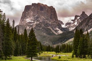 USFS photo | |
From the deserts of New Mexico to the alpine peaks of the northern Rockies, the Continental Divide Trail winds its way through the stunning and diverse landscapes of the central United States, a ribbon that ties together many of the defining moments and movements in our nation’s history.
The trail stretches across the United States some 3,100 miles between the borders of Mexico and Canada, twisting and turning to follow the spine of the continent. The dry, sandy deserts of New Mexico slowly rise into the breathless peaks of Colorado, descending into Wyoming’s grassy plains and the mystical landscape of Yellowstone. The trail then moves along the forested mountains of Idaho and Montana before ascending the tall, sharp, rocky peaks of Glacier National Park, with the Canadian border on the horizon.
The Continental Divide Trail blazes a path through some of the nation’s most treasured scenic terrain. Some people attempt to travel the entire 3,100 miles in a single season, while others enjoy the trail a few miles at a time.
What is the Continental Divide?
The headwaters of our nation spring from the Continental Divide. Imagine a line running the entire length of North and South America, from the icy northern reaches of Canada to the Strait of Magellan at the southernmost tip of Chile. This line runs north to south along the very highest elevations of these continents, connecting the peaks of the Rocky Mountains with the Andes in South America.
Rain or snow that falls on these peaks will flow either to the east or to the west down the slopes of these mountain ranges. This flow begins as small trickles that join up to form streams, then swell into roaring rivers that provide nourishment to the land, plants, and animals.
Those first trickles of water that flow to the west of the Continental Divide eventually end up in the Pacific Ocean. The water flowing eastward will someday reach the Atlantic Ocean. In this way, the waters of the continent are divided.
The Continental Divide Trail follows the length of the Continental Divide within the United States. To walk along the trail is to have one foot in the watershed of the Atlantic Ocean and the other in the watershed of the Pacific.
A Natural Boundary
The headwaters of our nation spring from the Continental Divide. The map below shows how water flows from the Continental Divide into streams and rivers that eventually make their way to the oceans.
Choose a small stream that begins on the eastern side of the Divide, the white line on the map, and notice how it joins up with other creeks and streams to become a larger and larger river, finally ending its journey at the Atlantic Ocean. All of the streams that run together into the same river make up that river’s watershed. Major watersheds are shown in different colors on the map.
Many of the nation’s mightiest rivers begin as a trickle of water near the Continental Divide. The Columbia and Colorado rivers flow west to the Pacific Ocean, while the Missouri River, the Mississippi River, and the Rio Grande flow east from the Divide to the Atlantic Ocean.
Humans and the Divide
Though the Continental Divide separates the waters of North America, for thousands of years it has brought people together.
The first people to see, name, and live among the lakes, rivers, and mountains of this land were the indigenous peoples of North America. Along the Divide in the southern deserts of modern New Mexico, the Zuni and Acoma Tribes established a trail between their pueblos that has been used for over 1,000 years. Ancient stone bridges and cairns built by the Zuni and Acoma to mark their way are still used by hikers on the Continental Divide Trail today. Far to the north, the Blackfeet Nation named the steep mountains of the Divide “Mistakis,” the “backbone of the world.” These peaks in Montana and southern Alberta, Canada are central to the creation story of the Blackfeet people. Similar cultural connections for indigenous people exist along the entire length of the Continental Divide. These lands are still home to Native American people who continue to cherish the homelands of their ancestors and their future generations.
European settlers in the 17th and early 18th centuries encountered the Continental Divide as a deadly obstacle during their push for westward expansion. While searching for a water route to the Pacific Ocean, Lewis and Clark crossed the Divide at Lemhi Pass in Montana. Families struggling westward on the Oregon Trail crossed through South Pass in Wyoming, just north of the Great Divide Basin. At the time, this was the only safe way for wagons to cross the Rocky Mountains.
The Continental Divide Trail runs right through the historic town of South Pass, allowing trail travelers a direct connection to the paths of these settlers along their westward migration, and a window into this pivotal era in our nation’s history. The map to the right shows the migration routes that are now designated as National Historic Trails, and where they cross the Continental Divide Trail on their journeys west.
A Trail for the Divide
In the 1960’s, public concern about industrialization, urbanization, and vanishing access to natural spaces was growing ever stronger. Landmark environmental laws such as the Clean Air Act and the Wilderness Act were flying off the presses at Congress, and not least among them was the National Trails System Act of 1968. This Act set the stage for a network of long-distance trails throughout America, each line on the map carving out a path both for recreation and for the conservation of the incredible landscapes along each trail.
The Continental Divide Trail was designated by Congress as a National Scenic Trail in 1978, and the Forest Service was given the responsibility to manage the trail. At the time, the trail was more like a patchwork than a continuous footpath - shorter trails and dirt roads along the Divide were linked up to create a route, but there were many gaps where the trail only existed as a line on the map. Much of the Continental Divide Trail’s character comes from its patchwork origins: the entire trail is open to hikers and equestrians, but some sections allow other uses like mountain biking or motorized vehicles, since they were allowed before that section became part of the larger Continental Divide Trail. In the decades since, the gaps between existing trails have been filled in to create a continuous path on the ground.
Moving Forward
The history of the Continental Divide Trail is not complete - there’s more work to be done! As of 2018, 96 percent of the Trail is located on federal land managed by the US Forest Service, Bureau of Land Management, or the National Park Service. Though the trail now provides a continuous, marked route from Mexico to Canada, a number of sections are currently routed along roads or highways. The US Forest Service is working with other federal land management agencies and the Continental Divide Trail Coalition to acquire key plots of land, secure easements, and build new sections of trail to provide for safe, permanent public access and better recreation opportunities along the entire trail.
New Mexico (820 Miles)
The southern end-point of the CDT can be found in the bootheel of New Mexico, at the Mexican border. Most thru-hikers, people who attempt to traverse the entire trail in one go, will start here to avoid the deep snow still clinging to the mountains in Montana during the spring. In the expanse of the Chihuahuan Desert, the Continental Divide may not be an obvious feature, but the hidden life of the desert may reveal itself to those who look closely. Gila monsters and javelinas roam through the mesquite, yucca, and grasses of the Chihuahuan Desert, but more likely encounters are with smaller reptiles and diverse bird life.
To the north, the trail passes through El Malpais National Monument, a sea of dark volcanic rock. The blooms of wildflowers and cactus add splashes of color to the landscape, and the region is home to the oldest Douglas fir trees in the American Southwest. Herds of elk roam the land, and bats find roosts in the lava tube caves left by ancient volcanic activity.
Higher elevations in New Mexico are dominated by Pinyon-juniper and Ponderosa pine forests, home to larger mammals such as gray foxes, black bears, elk, and mule deer.
Colorado (750 Miles)
The CDT in Colorado is dominated by the sharp, tall spine of the Rockies. The average elevation of the trail in Colorado is 10,000 feet above sea level, and along the way summits the highest peak on the Continental Divide, and also the highest elevation of any National Scenic Trail: Gray’s Peak, a stunning 14,270 feet above sea level. The alpine tundra and high-elevation pine forests of Colorado are home to mountain goats, coyotes, pikas, black bears, and elk.
Heading north from the border with New Mexico, the CDT soon enters the Weminuche Wilderness, Colorado’s largest designated wilderness area, situated in the Rio Grande and San Juan National Forests. This 100-mile section of the CDT is known for its ruggedness and isolation, and presents a thrilling and rewarding challenge for hikers.
Other alpine highlights along Colorado’s Continental Divide Trail include the Collegiate Peaks and Rocky Mountain National Park, both boasting unparalleled views of glacial lakes, deep rounded valleys, and sharp, snow-capped summits.
Wyoming (510 Miles)
The Continental Divide Trail traverses diverse and unique landscapes in Wyoming. Descending northward from the high peaks of Colorado, the trail enters the Great Divide Basin. Here, the Continental Divide splits into two, forming a circle around a vast desert-like plain. The small amount of precipitation that does fall in this basin does not join streams or rivers flowing to the Atlantic or the Pacific Ocean, but stays put, absorbed by the thirsty earth. Wild horses roam this desert, along with pronghorn, mule deer, and diverse bird life.
To the north, the CDT climbs out of the desert and into the mountains of the Wind River Range, known for its jagged peaks and alpine meadows. The Wind River Range also contains 7 of the largest 10 glaciers in the lower 48 states. Wildlife in the mountains of Wyoming is truly wild, with remote forests and glacial valleys providing habitat for moose, elk, deer, black and grizzly bears, and mountain lions.
A stunningly unique highlight in the northeastern corner of Wyoming is the famed volcanic landscape of Yellowstone National Park. The Continental Divide Trail passes directly by the nation’s favorite geyser, Old Faithful, but also offers opportunities to enjoy less-traveled areas of the park containing geysers, colorful hot springs, and diverse wildlife.
Idaho and Montana (1020 Miles)
The Continental Divide Trail weaves along the border of Montana and Idaho before turning north, traversing Big Sky Country towards Glacier National Park and the Canadian border. Here, the trail passes through open prairies, forested valleys, and majestic mountains, which provide habitats for large wildlife such as mountain goats, grizzly bears, and gray wolves, as well as beavers, river otters, and bald eagles. Streams flowing from the Continental Divide are packed with trout, making this region popular for recreational fishing.
A memorable location on Montana’s CDT is the tall, unbroken limestone cliff face of the 22 mile long Chinese Wall in the Bob Marshall Wilderness, situated within the Flathead National Forest.
The lowest elevation along the Continental Divide Trail, at 4,200 feet above sea level, is actually at the northern endpoint of the trail: Waterton Lake on the Canadian border.
Source: USFS Website (December 2023)
|
Establishment Continental Divide National Scenic Trail — November 10, 1978 |
For More Information Please Visit The  OFFICIAL USFS WEBSITE |
Documents
Comprehensive Plan: Continental Divide National Scenic Trail (September 2009)
Interpretive Plan: Continental Divide National Scenic Trail (2015)
Map: Continental Divide National Scenic Trail (Date Unknown)
Marking Guide: Continental Divide National Scenic Trail (October 2017)
cdt/index.htm
Last Updated: 01-Jan-2025