|
Florida National Forests |
|
Apalachicola National Forest
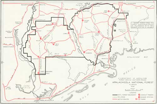
THE Apalachicola National Forest is located southwest of Tallahassee, the State capital, and extends from within a few miles of Tallahassee to the Apalachicola River. State Highway 19 is the northeast boundary of the forest and State Road 110 and U S 319 bound the forest on the east side. The forest is divided into two parts by the Ochlockonee River. The Wilma district, with a gross acreage of 306,395 acres, lies west of the river, mostly within Liberty County with the southwest tip extending into Franklin County. Wilma is the headquarters of the ranger in charge of this district. The Wakulla district, with a gross acreage of 325,850 acres, lies east of the river, within Leon and Wakulla Counties. Tallahassee is the headquarters of the district ranger. The Wakulla district was added to the Apalachicola by Presidential proclamation on June 21, 1938. Prior to this proclamation the area had been administered as the Wakulla project by the Farm Security Administration. Four towers have been constructed on the Wakulla district, on areas developed as subsistence units with the necessary buildings to make each a self-contained habitation. The district contains a typical work center of warehouse, garage, shops, and water system.
|
|
APALACHICOLA NATIONAL FOREST (click on image for a PDF version) |
When the Apalachicola unit came under the control of the Forest Service, it was one of the last backwoods areas of north Florida, but an intensive C. C. C. program has transformed it. A network of graded roads has made the extensive resources accessible for utilization and made it possible to get men and equipment in quickly in case of forest fires. The forest was established primarily to stabilize a decadent community, which had depended almost entirely upon the timber resources.
Timber on the Apalachicola National Forest will be managed for saw timber as the final crop. Intermediate crops will be pulpwood, naval stores, cross ties, and fuel wood. The present annual yield of pulpwood is estimated at 13,000 cords. This yield is expected to increase materially as soon as the wrecked remnants of former naval stores and logging operations are removed and new second growth comes into merchantability. Some two or three small naval stores operations are dependent on this forest as a source of timber. Because of the close utilization of resources in the past, however, these operations must be conducted on a small scale.
|
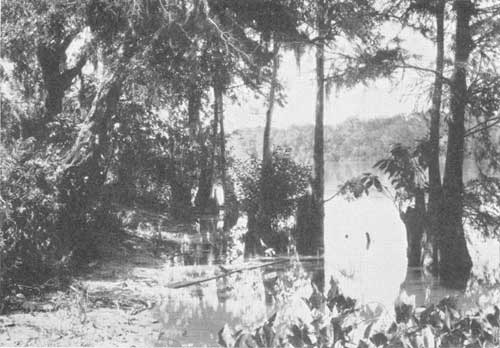
| SCENE ON THE APALACHICOLA RIVER NEAR FORT GADSDEN F—352676 |
This forest is topographically similar to the Osceola, being flat and wet with numerous ponds and swamps. Longleaf and slash pine grow and reproduce well on the higher grounds of the flatwoods. Cypress and hardwoods grow in the ponds, and southern white cedar grows along the stream bottom. Northwest of Vilas is a higher, dry area of ridge type—longleaf pine with turkey oak as an understory.
The swamp and overflow lands along the Apalachicola River are extremely interesting botanically. Here, as a result of seed and silt carried down and deposited by the river, are trees whose natural habitat is far to the north of this latitude. Trees, such as beech, ash, elm, and yellow poplar, which are more characteristic of the Southern Appalachians than of Florida, make up a large part of the bottom-land hardwood stands. Along the limestone bluffs and ravines of the Apalachicola River north of the forest the rare Florida yew, Taxus floridana, and stinking cedar, Tumion taxifolium, formerly, and still, designated as Torreya taxfolia, occur. To preserve these interesting forms, the State has set aside an area as the Torreya State Park.
|
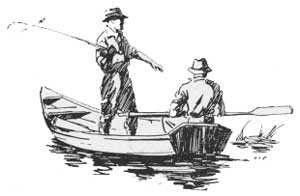
| PLANS ARE BEING MADE TO IMPROVE THE FISHING ON THE FLORIDA NATIONAL FORESTS F—313087 |
The remains of Fort Gadsden on the Apalachicola River are located within the forest. This fort was built by the English in 1812 and destroyed by the United States in 1816. It was rebuilt by General Jackson in 1818 and used during the Seminole wars. Since then most of the materials have been salvaged in building the town of Colinton.
The topography of the Apalachicola Forest is low and swampy, and suitable natural beauty spots adaptable for development as picnic areas are rare, except on the Wakulla district. Simmons Lodge, an abandoned structure, acquired with the tract of the same name is the site of a proposed organizational camp. Construction of a dam will provide swimming facilities at this point. Dog Lake is a potential recreation area.
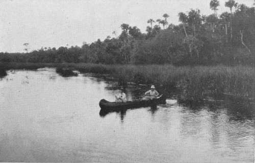
Fishing is an important recreation use in this area. On the three streams and their tributaries which drain the forest are many miles of fishing waters. Opportunities for hunting are limited because the area is largely shot out, only a few deer, bears, and turkeys remaining. A game-breeding ground, with an area of 49,978 acres, was established by the State Commission of Game and Fresh Water Fish on November 10, 1937. This refuge, which was closed to hunting and trapping for a 5-year period, lies in a portion of the district known as Simmons pasture.
Under the cooperative agreement recently entered into by the United States Forest Service and the State of Florida, a restocking and development program is planned, which promises to restore an abundance of wildlife in this forest.
| <<< Previous | <<< Contents>>> | Next >>> |
|
handbooks/florida/sec6.htm Last Updated: 19-Nov-2010 |