|
Ouachita National Forest |
|
CAMPGROUNDS AND PICNIC AREAS
INNUMERABLE springs and clear, cold mountain streams make motoring and camping in the Ouachitas ideal. Camp and picnic grounds have been developed in suitable locations and include shelters, tables, benches, fireplaces, and drinking water and sanitary facilities. Efforts have been made to keep the natural beauty unspoiled and all work has been done in a way to harmonize with natural surroundings.
|
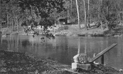
| SWIMMING POOL—JACK'S CREEK, RECREATION AREA F—314435 |
The only condition imposed upon the users of these facilities is that they abide by the camp regulations posted in each spot. It is expected that visitors will always leave their campgrounds as they would like to find them.
Ouachita Camp.—United States Highway 270, near Hot Springs. Picnic and swimming use.
Charlton Camp.—United States Highway 270. About 20 miles from Hot Springs, Ark. Swimming and picnicking.
Crystal Camp.—Womble—Silver Road, near Norman. Picnicking and swimming.
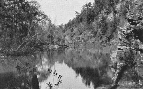
Albert Pike.—Blaylock and Polk Creek Roads near Norman. Picnicking, camping, and swimming. Of historical interest as the site of the mountain retreat of Albert Pike, the master genius of Masonry. It was here that Pike wrote the well known "Morals and Dogma", famous compilation of Masonic philosophy. The swimming hole here is a natural pool in a setting of cool shade and attractive rock outcroppings.
Mine Creek.—Shady-Mena Road, near Mena. Swimming, picnicking, and camping.
Bard Springs.—Blaylock Road, near Mena. Swimming, picnicking, and camping. The natural attraction here is the reputedly medicinal waters to which the mountain folk have made pilgrimages for generations. The area nestles in a rugged forest region near Buckeye and Blaylock mountains, Fodderstack and Raspberry Peaks standing like silent sentinels on guard.
Iron Springs.—State Highway 7. About 20 miles from Hot Springs. Picnicking, swimming, and camping.
South Fourche.—State Highway 7. About 30 miles from Hot Springs. Picnicking, swimming, and camping.
Knopper's Ford.—Freedom Gap Road, near Waldron. Swimming, picnicking, and camping.
Sugar Creek.—Freedom Gap Road, near Waldron. Picnicking only.
Shady Lake.—Big Fork-Athens Road, near Mena. Swimming, boating, camping, and picnicking. A 21-acre lake of sparkling clearness in the heart of the mountains. An ideal spot for a picnic or for pitching a tent.
|
| ALBERT PIKE CAMP ON LITTLE MISSOURI RIVER F—314344 |

|
| REGISTRY PORTAL—HORSETHIEF SPRINGS F—338028 |
IN THE OKLAHOMA DISTRICT
Billy Creek.—Twenty miles off United States Highway 270, near Pine Valley. Picnicking and swimming.
Horsethief.—Winding stairs truck trail. Picnicking only. This unit is located near the top of Winding Stair Mountain, about an hour's drive from Heavener. The area centers about Horsethief Springs, famous in the almost forgotten days of traffic in horses stolen in Texas and driven north through the Missouri mountains for sale.
Bear Caves.—Winding stairs truck trail. Picnicking only.
SCENIC TRAILS FOR THE HIKER
THROUGHOUT the forest there are numerous foot trails leading into primitive regions and scenes of rugged forest beauty. No artificial development of any sort will be attempted in these stretches of solitude, where the lover of the great outdoors can find seclusion in districts rarely trodden by the foot of man.
Crystal Mines.—In the Crystal Mountain region, near Norman, reached by a trail leading from the Womble-Silver road. This mountain receives its name from the abundance of rock crystals found in veins in the quartzose sandstone of which the mountains are composed.
Little Missouri Area.—With its rugged picturesqueness, affords unlimited possibilities for the student and lover of nature. The Little Missouri Falls may be reached by a foot trail from the Mena-Shady Road.
Standing Rock, a spectacular rocky formation, is reached by trail from the Mena-Shady Road.
Nearly all of the campgrounds have trails leading to various points of interest or to panoramic views. At Camp Ouachita a foot bridge over a small inlet in the Ouachita River connects the camp with forest trails which will lead hikers into beautiful territory. Petit Jean Trail along the top of the Petit Jean Mountains offers a delightful trip for those who travel afoot or horseback.
The lookout towers, built for forest fire detection, are all reached by road or trail. The locations of these towers usually afford exceptional vistas of the forest-clad hills, rugged gorges, and high peaks that form an unforgettable picture.
ROUTES FOR THE MOTORIST
THE Ouachita National Forest is accessible by a network of Forest Service roads, connecting with State and Federal highways. United States Highway 270 runs almost through the center of the forest, from east to west, going into the Oklahoma section of the forest. Ouachita, Charlton, and Crystal Camps are all just off of this route. Collier Springs is reached by a Forest Service road from this highway. Near the Oklahoma State line, a Forest Service road branches off from the highway up Rich Mountain, on the north slope of which may be found more species of wild flowers than in any other area of like size in the State.
United States Highway 70 traverses the eastern boundary of the forest and connects Hot Springs and Little Rock. Roads 7 and 9 both branch off from this highway.
State Highway 8 runs from Norman to Mena. Off from this road are Albert Pike, Mine Creek, and Bard Springs campgrounds. The Forest Service roads connecting with this route afford some of the most picturesque scenery of the forest. Mena, attractive to the tourist and vacationist seeking recreation in the mountains, is popular because of its unexcelled climate. It is noted for its cool summer nights.
State Highway 7 leads to the northern part of the forest. Iron Springs and South Fourche campgrounds are on this road which borders Oak Mountain Game Refuge. Several lookout towers are accessible by Forest Service roads, leading off from this route.
State Highway 9 also leads to the northern part of the forest. From this road North Fork Pinnacle can be reached.
ROADS OF THE FOREST SERVICE
THE Forest Service has developed and maintains over 1,500 miles of good roads within the forest. They make the most remote parts of the forest accessible. Many of them lead through interesting Arkansas mountain-life settings.
Many of these roads were constructed by the CCC and have opened up rugged areas which until recent years were enjoyed by only a few hardy hikers or horseback riders who pushed their way into these remote places. They were constructed primarily as a means of fire control, but are open to the public and offer opportunity for enjoying the scenic beauty of the forest.
The Womble-Silver Road leaves United States Highway 270, two and one-half miles west of Crystal Springs and leads to Norman through beautiful Crystal Mountain, opening up vast scenic panoramas. On this road a few miles from Norman, Ark., is Collier Springs, with shelter and trails. Here water gushes from the ground at the rate of 3,000 gallons per hour. Farther along is Crystal campground, where swimming and picnicking facilities are to be found.
The Shady-Mena Road, which branches from State Highway 8, about 20 miles from Mena, passes Mine Creek camp site. The Big Fork Athens Road branches from this road and leads to Bard Springs campground and Saline Lake, where camping, swimming, and picnicking are available.
The Gladstone Road leaves Highway 7 and leads through a most picturesque section of the forest. It passes through Aly and the Dutch Creek Mountain region.
The Petit-Jean Road, a scenic mountain drive, is reached from Waldron by way of United States Highway 71, Girard Road, and Freedom Gap Road. On Freedom Gap Road is Knopper's Ford campground, where there are facilities for camping, picnicking, and swimming.
The Winding Stair Road in Oklahoma, leads from the United States Highway 270 up the Winding Stair Mountain. It passes Horse Thief and Bear Caves camp sites and opens up a beautiful scenic section of the forest.
The Rich Mountain Top Road, which should be completed in 1937, will be one of the most picturesque of all scenic drives on the forest. It begins at the city limits of Mena and climbs the range to the top of Rich Mountain the highest mountain in the forest, with an elevation of 2,800 feet above sea level. It follows along the top of the mountain, a distance of 18 miles to the Oklahoma State line, then swings south down the ridge to intersect the Talihina Highway 88 near Commonwealth College. A spur from this road leads north down the mountain to Highway 270 at the town of Rich Mountain. This road traverses a rugged scenic section, and at the north and south are opened up beautiful vistas revealing the majestic sweep of mile upon mile of forested mountains.
The drive will lead by the old town site of Mount Mena where the ruins of the old Wilhelmina Hotel still stand as a monument to the gay nineties, when this popular summer resort was built. The once spacious hotel took its name from one of its first distinguished guests, Queen Wilhelmina of Holland.

|
|
GLADSTONE FOREST ROAD ALONG NORTH FORK CREEK Roads have been carefully located to preserve landscape beauty F—261599 |
| <<< Previous | <<< Contents>>> | Next >>> |
|
handbooks/ouachita/sec5.htm Last Updated: 19-Nov-2010 |