|
National Forests in the Southern Appalachians
|
|
Where Rivers Are Born
TWO GREAT ranges of mountains sweep southwestward through Tennessee, the Carolinas, and Georgia. Centering largely in these mountains in the area where the boundaries of the four States converge are five national forests—the Cherokee, Pisgah, Nantahala, Chattahoochee, and Sumter.
The more eastern of the ranges on the slopes of which these forests lie is the Blue Ridge which rises abruptly out of the Piedmont country and forms the divide between waters flowing southeast and south into the Atlantic Ocean and northwest to the Tennessee River en route to the Gulf of Mexico. The southeastern slope of the ridge is cut deeply by the rivers which rush toward the plains, the top is rounded, and the northwestern slopes are gentle. Only a few of its peaks rise as much as a mile above the sea. The western range, roughly paralleling the Blue Ridge and connected to it by transverse ranges, is divided into segments by rivers born high on the slopes between the transverse ranges. The transverse ranges vary in character, but are usually higher and bolder in configuration than the Blue Ridge. Much of their crestline is at least a mile above sea level and they have many peaks more than 6,000 feet high. The segments of the western range are also as a rule higher than the Blue Ridge and more rugged and precipitous.
Although there is considerable variation in the amount of rainfall in the region the average is higher than for the country as a whole and in some sections of the mountains is higher than for any other part of the United States except portions of the Pacific coast. Situated as they are, spreading a protective mantle over these lands where rise the headwaters of such rivers as the Tennessee, Savannah, and Chattahoochee, the national forests of the southern Appalachians exert an influence over the well-being and prosperity of people and communities in rich agricultural areas many hundreds of miles distant. The waters of these forests are a source of domestic supply for busy cities, the power generated as they run to the seas turns the wheels of industries, and their steady flow contributes to the year-round navigability of the Mississippi.

|
| Power from national-forest waters: Streams whose watersheds are protected have a more even flow. F—386645 |

|
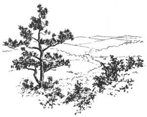
| Forested slopes conserve rainfall: A portion of the Tellico Fish and Game Management Area in the Cherokee National Forest. F—386650 |
The peculiar topography of the southern Appalachian region, with its interior valleys cut off from the Piedmont and Coastal Plain by an unbroken rampart, its river systems separated one from another by high ranges of mountains, and access to the great valley of the Tennessee blocked by mountains cut by rocky gorges, has had a notable influence on the settlement and development of the region. Railway and highway construction encountered such obstacles that it is only within the past generation that the section has been well opened up. Even today there are considerable areas without modern means of transportation.
|
PRESERVE NATURAL BEAUTY HELP PREVENT FIRES |
Home of the Cherokees
IT IS POSSIBLE that De Soto, in 1540, was the first white man to see this southern Appalachian region; there is some evidence also that the expedition of Don Tristan de Luna y Arellana penetrated to the western tip of North Carolina in 1560. The first white comers found the Cherokee Indians occupying the land. These Indians lived in permanent villages and grew corn, pumpkins, and other crops, not depending entirely upon the chase for a livelihood. Their capital, Echota, was located near the site of the present town of Tellico Plains, within the boundaries of the Cherokee National Forest.
For many years prior to the French and Indian wars, most of the region was under nominal control of the French. Fort Loudon, whose ruins may still be seen at the junction of the Tellico and Little Tennessee Rivers, was the most western outpost of English civilization on the American Continent. It was built by the British in 1756 and captured and its garrison massacred by the French and Cherokees in 1760.
It is probable that the first English—Indian traders from Virginia—entered the region about 1730. The southern mountains were settled by pioneers sifting down the valleys from western Pennsylvania rather than across the forbidding ramparts of the Blue Ridge. Most of these early comers were Scotch and Irish, the stock that developed such men as Daniel Boone, John Sevier, Davy Crockett, Sam Houston, and Abraham Lincoln. As the colonists pressed more and more strongly south and west through the mountain valleys, the resistance of the Cherokees stiffened until the border was ablaze with warfare. In 1776, punitive expeditions penetrating deeply into the wilderness burned over 30 Indian towns, and so weakened the Cherokee Nation that the Indian menace was ended.
The record of the white man's dealings with the Cherokees for the 60 years following 1776 is not pleasant. Valley by valley, range by range, the Indians reluctantly gave up their homeland. Finally, in 1838, the Cherokee Nation was moved west to lands in Indian Territory. Many perished en route; all looked back with longing eyes to the beautiful country they were leaving. Some of them evaded migration by hiding in the most inaccessible recesses of the mountains; others escaped en route and found their way back. Eventually these Indians and their descendants came to be known as the Eastern Band of the Cherokees. Most of them live today on the Qualla Indian Reservation in western North Carolina where they have retained their language and many of their customs and traditions. The lands of the dispossessed Cherokees were ceded by the States to white settlers. Gradually the rich valleys and bottomlands were placed under cultivation. Later comers tucked their little cabins of squared logs high on the slopes and in upland coves, sometimes farming land as steep as the slope of a roof, and land originally rich was soon so badly eroded that the formerly clear streams ran red with mud. Such land could not continue to yield a decent living from farming and infinitely better might have been left in forest to protect stream flow and yield successive crops of forest products.
|
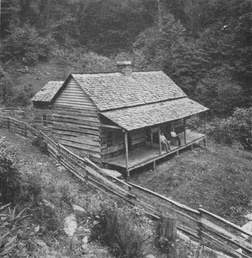
| An old-time mountain cabin with hand-hewn log walls and a split shake roof. F—15480A |
| <<< Previous | <<< Contents>>> | Next >>> |
|
handbooks/southern_appalachians/sec1.htm Last Updated: 19-Nov-2010 |