|
The Clearwater Story: A History of the Clearwater National Forest |
|
Chapter 10
Railroad Surveys
As early as 1854 Government officials and railroad men were thinking of constructing a railroad from the Great Lakes to Portland. Captain Mullen looked for the best road route from Fort Benton, Montana to Walla Walla, Washington. He also scouted the country for the best route for a railroad. His findings had much to do with the route selected for the Northern Pacific Railway. In 1855 Governor Stevens of Washington Territory recommended the route the Northern Pacific followed.
In 1864 Congress chartered the Northern Pacific Railway Company. This company was to build a railroad from Lake Superior to Portland and Puget Sound but the exact route to be followed was left for later determination. The route by way of Sandpoint was tentatively adopted.
In 1870 the directors of the Northern Pacific decided to investigate other routes across the mountains. One ran from Three Forks, Montana, up the Beaverhead River and down the Salmon River to Lewiston, Idaho and on west. Another went via Missoula up Fish (then called Fishery) Creek and down the North Fork of the Clearwater, on to Lewiston and west. A third went up the St. Regis River and down the Coeur d'Alene River and west. The fourth was the present route through Sandpoint. At that time the possibility of following the Lochsa River was not considered.
In 1870, 1871 and 1872 these routes were surveyed. Only the survey of the North Fork of the Clearwater will be covered here. I am unable to say who was in charge of the 1870 survey. This survey and the one down the Salmon River were described by the Northern Pacific as "The most difficult instrumental surveys ever made in the United States." The North Fork Survey ran up Fish Creek through the pass at Goose Lake (5,800) and from there down Goose Creek to the North Fork of the Clearwater and down the Clearwater to Lewiston, Idaho. From where the survey reached the North Fork to its mouth there were no trails. The canyon was steep and rocky; much of it was heavily timbered. It is remarkable that a survey could be conducted in such a short time under such difficult conditions. The route proved to be impractical, but an accurate charting of the course of the North Fork resulted. Some modern names of creeks are shown on the plat of this survey and it is probable that the surveyors gave them these names.
The 1908-09 Survey
The Northern Pacific and Union Pacific each decided to survey a railroad through the Lochsa and Middle Fork canyons. A railroad on this location would provide a shorter route from Portland to Missoula. Apparently each conceived the idea at about the same time; each started surveys in the spring of 1908.
A race developed to see which could complete the survey first and thus acquire the key points on the right-of-way. This was wild inaccessible country with almost no trails and some very bad rocky canyons. To make a quick survey required almost an army of men. Accordingly, the Lochsa canyon and trails heading to it were filled with laborers, packers, packstrings, surveyors and all the personnel, equipment and supplies necessary to make a survey. Haste was the order of the day. Money was spent like water. Where possible, trails were built along the river. Where too rocky, supplies were brought in either over the Lolo or Coolwater Ridge trails and down branch trails to the river.
A graded trail was built from the Lolo Trail to the mouth of Weir Creek. Another ran from Sherman Peak to Boulder Flat. A branch of the Coolwater Trail ran past Maude and Lottie Lakes to Boulder Creek.
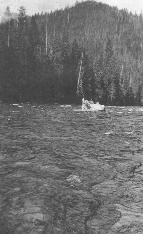
An effort was made to run supplies down the Lochsa River from Powell by raft, but it capsized. All supplies and equipment were lost, but luckily no one drowned. Boats were used on the Middle Fork and up the Lochsa as far as Hellgate Rapid. This was the end of navigation. Hellgate Creek took its name from the rapids.
The survey work continued through 1908 and 1909. The Northern Pacific started to build a railroad out of Lolo, Montana. Then, all at once, all work stopped. The two companies agreed that neither would build a railroad here. The trails were taken over by the Forest Service. Some sections were improved, but for the most part, the old trail along the river remained the same until the highway was built.
When I traveled over the old trail in 1924, sections of survey lines and stations could still be found. Today it is hard to find even an occasional blaze. Up to 1959 there was still a survey stake setting in a mound in Colgate Warm Spring, but it fell over in 1960. Apparently the hot water has preserving properties. There is a toppled cedar tree near the spring with a benchmark.
Just why the idea of a railroad on this location was abandoned no one seems to know. Cost may have been the deciding factor; but it was likely a change in railroad plans and policy. Governor Dixon of Montana, in a talk before the Missoula Chamber of Commerce in 1922, stated that had Jim Hill lived 90 days longer the railroad would have been built. Jim Hill was president of the Northern Pacific. Out of this survey the idea for a road through the Lochsa to Missoula originated.
In 1913 the Northern Pacific surveyed another railroad location. This time it was from near Superior, Montana up Fish Creek with a proposed tunnel under the crest of the Bitterroots and then down Kelly Creek and the North Fork of the Clearwater to Ahsahka. They hoped this would be cheaper and shorter than the Lochsa route. It would be closer to the timber holdings of the Weyerhaeusers who were talking of a railroad to their holdings. It turned out to be a great disappointment; it was both longer and costlier than the Lochsa route. A separate railroad was built to the Weyerhaeuser timber holdings around Headquarters in 1925.
|
| Northern Pacific Railroad survey crew rafting down the Lochsa River in 1909. Shortly after the photo was taken the raft was upset and all the supplies were lost. |
| <<< Previous | <<< Contents>>> | Next >>> |
|
clearwater/story/chap10.htm Last Updated: 29-Feb-2012 |