|
The Clearwater Story: A History of the Clearwater National Forest |
|
Chapter 22
Wilderness Gateway or Boulder Flat
The area around the mouth of Boulder Creek has been developed as a camping area and a take-off point for parties packing up Boulder Creek and on into the Selway-Bitterroot Wilderness Area. For a number of years this place was known as Boulder Flat. It took its name from Boulder Creek which is an old name shown on the maps as early as 1895.
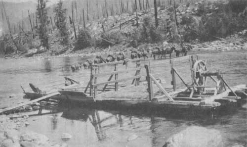
For a time (about 1922 to 1925) there was a Ranger Station consisting of a cabin and a corral located on the north bank of the Lochsa River and below Sherman Creek. It was called Boulder Ranger Station. There was also a ferry across the river at this point. The cabin was later taken apart and floated piece-by-piece down the river and skidded to the Lochsa Ranger station where it was reassembled. It is there today.
The Boulder Flats have been subjected to two severe fires in my lifetime. The first was in 1910 and then in 1934. I was at Boulder Ranger Station in 1924 and that part of the flat on the south side of the river was well populated with huge dead cedar trees that were killed in the 1910 fire. While looking at the snags one day one man remarked "If you could just get them to the market there are enough posts there to fence the United States". Well the road didn't arrive until 1953 and by that time nearly all the posts had been burned in the 1934 fire.
The formation of Boulder Flats is an interesting geological story. At the start of the Glacial Age, snow falling in the high country around the Crags at the head of the various forks of Boulder Creek failed to melt during the summers. After many years accumulation of snow, glaciers formed in each of these drainages such as Surprise Creek, Cliff Cr. and Boulder Creek itself. With an increase of snow each winter these glaciers from sheer weight moved slowly down stream. During the summers a part of these glaciers would melt but each winter's supply of snow was greater than the melt, so each year these glaciers grew deeper and advanced a short distance.
Then the glaciers from each of the side streams joined and year by year the leading edge of the glacier moved down Boulder Creek. There were years when the melt would exceed the snowfall and the glacier would stop or make a slight recession only to advance again in the following years of heavier snowfall. The glacier was a slow moving but powerful force.
Finally this glacier approached the Lochsa River shoving ahead of it millions of tons of mud, rocks, boulders, sand, and ground up timber. When this huge mass came to the Lochsa River the river first washed away large quantities of this material and scattered it downstream as far as the Pacific Ocean. But the glacier inched slowly forward forcing the river against the north bank where it undermined the hillside and made a cliff into the river. Then the glacier drove its nose hard against the north bank and dammed the Lochsa River thus forming a lake above the glacier. The water from this lake flowed over the top of the glacier. Into this lake the Lochsa River and Sherman Creek washed rocks, sand, and mud, partially filling the lake.
The glacier started to move down the Lochsa Canyon. It shoved a huge pile of mud into the mouth of Zion Creek and formed the bench upon which the Lochsa Work Center is located. Then the whole process began to reverse itself. The snowfall became lighter than the summer melt of snow. The glacier continued to move but it could not keep up with the results of warmer weather. The ice melted until the lake burst through the mud, rocks, and other debris which was no longer reinforced with ice. The river cut a channel through the glacial debris which had collected in the lake leaving the flats around the mouth of Boulder Creek and the remnants of the glacial moraine at Lochsa Station. The lake apparently went out with considerable force scattering rocks and boulders down river to below Fish Creek.
After the glacier had receded up Boulder Creek, it made another advance and stopped just short of reaching the Lochsa River. It piled a small knoll of rocks and gravel on the south bank of the river just below Boulder Creek.
In the process of receding up Boulder Creek, there were other times when the glacier would make another advance and leave a mass of debris, called a moraine, across Boulder Creek. Usually small lakes formed behind these piles of debris after the ice melted. These lakes would partially fill with mud and the creek would wear a channel through the moraine. These old lake beds with the rich soils became meadows. There are a number of these on upper Boulder, Surprise, and Cliff Creeks.
One of the moraines on Boulder Creek was exceptionally high and made largely by boulders. The old trail wound up over this moraine through a narrow pass between the boulders and was called Boulder Pass. The trail now goes around the pass.
As the glacier melted it dropped boulders, rocks, sand, and mud all along Boulder Creek. The creek being much larger than it is today, due to the melting ice, removed much of the finer material leaving the creek channel a series of boulders from which the creek gets its name.
|
| The ferry across the Lochsa at Boulder Creek, about 1924. |
| <<< Previous | <<< Contents>>> | Next >>> |
|
clearwater/story/chap22.htm Last Updated: 29-Feb-2012 |