|
Early Days in the Forest Service Volume 3 |
|
"CHIPS" FROM THE YEARS OF SERVICE IN R-1
By Earl D. ("Sandy") Sandvig
(Retired 1959)
I thought I had a great idea when I started this narrative. My years in Region One (1922-44) took me into all the Forests of the Region. My original plan was to describe some incident that had happened to me on each Forest. It sounded good, but my skill in weaving my way through the several Forests of the Region became hopelessly enmeshed in a flood of words. If you have persistence enough to read the next several pages, you will understand my dilemma.
The Helena, 1922-24
During summer vacation of my junior year in school I needed a job. To reach that objective, I spent a great deal of my time knocking at the office doors of Glen Smith and Leon Hurtt. Finally, to get rid of the annoyance, I was hired as a temporary field assistant and assigned to a party making a range survey on the Helena.
It was a beautiful June day as "Chick" Joy and I stepped off the train at Townsend. There we made contact with a team of mules plus a two-seated surrey. It had seen better days and carried fancier company, but it was loaded with grub. Included with the camp gear was a cook. He was slightly indisposed from liquid refreshment but that didn't bother us, or the mules either. Russ Beeson was our chief of party. Russ' kindly disposition, even temper and persistence coaxed those mules to haul us via Radersburg to the Eagle Creek guard station. There we were joined by Dave Poshusta from Ames, Iowa. Dave didn't like mules or pack stock either, and our cook was too elderly and too valuable a crew member to be exposed to those mules. The camp moving fell to Russ and me, as "Chick" had left us for the wilds of the Gallatin after our initial training period in range survey was finished.
It was a wonderful summer. Our cook proved to be a top-rated chef who could perform miracles as a culinary artist with an old tin campstove. He baked buns for our lunches, served pies and cakes and lots of substantial grub. We were livin' high on the hog, for that guy could take a can of salmon and fix it up to make you think you were eating lobster thermidor. He was the best, but when the ice began to freeze on the water bucket late in August his rheumatism, his thirst and his accumulated checks just naturally won over the gracious and tender treatment we accorded him after many a rough mile of mountain travel. Horrors. I have forgotten his name, but the demonstration of his artistry on a tin campstove permanently resides in my memory tank.
The summer passed quickly. We "tally-whacked" our way across the famed Crow Creek allotment, Slim Sam Basin and a lot of other places that haven't stuck in my memory as firmly as the artistry of our cook. Anyhow, late September and October found Russ Beeson and me "tally-whacking" our way across the Dry Range near the post office of Lingshire. We finally gave up "counting the grass" after about a foot of snow fell. We had long since parted company with the mules and the two-seated surrey in favor of a pack outfit. I went back to get more knowledge and a degree in forestry, and Russ started the tedious winter job of planimetering the acreage of the types we had drawn on our maps.
On June 1, 1923, I returned to the Helena, this time under probationary appointment as a grazing assistant. I was given the job of field party chief. Art Cramer, "Colonel" Canfield, Bert Cary, Bill McGinnies and Herb Schwan composed the crew. Labor Day found us camped on Hope Gulch above Marysville, Montana. A number of old sourdough prospectors lived along the creek. One of them frequently visited our camp, especially around suppertime. He liked our grub. I don't remember whether we kept meal records those days or not. Anyhow, we fed him quite regularly and in turn he regaled us with the stories of the big nuggets that had been found in Hope and other gulches in the vicinity. Those nuggets finally got to be the size of lard buckets and it was distracting. The crew's attention had changed from grass to gold nuggets.
Marysville was our supply and mail delivery point. The Drumlumon mine was operating. As I rode past it on the way back to camp the idea struck me that it would be good to get some ore samples and test our prospector friend's knowledge of gold-bearing rock. The superintendent of the mine cooperated and gave me several pieces of ore that had shown an assay of $1,800 a ton. Luckily, before I reached camp, I met Art Cramer at work mapping his assignment for the day. The sight of his map sheet gave me the idea to start the legend of the lost mine of Hope Gulch. I gave Art the ore samples, and he in turn visited the old prospector that afternoon to show him the samples and inquire if they were any good.
Art played his role perfectly. The old man got out his magnifying glass. His hand shook a bit over what he saw. Next he took a sample and crushed it with his mortar and pestle. Then he put the ore in a gold pan. As he panned, the glitter of gold reflected in the excited movements of the old man. Sure enough, a big gold discovery had occurred. "Where was it?" That was an easy question to answer. Art pulled out one of his map sheets, sketched in the drainage, ridge lines and other features that were easily identifiable, placed an "X" on the map as the point of discovery, and handed it to our raconteur of glittering gold nuggets.
The next day we moved camp and lost contact with our friend. He was an old man then but we probably lengthened his life by ten years in creating a new hope for him in Hope Gulch. Perhaps the search for the lost mine in Hope Gulch still goes on. A very accurate map, with one exception, must be in the possession of some sourdough.
The Lolo - St. Joe - Clearwater - Selway - Bitterroot - Kaniksu 1925-26
Sheep from along the Snake River in Oregon and Washington, and the Columbia River basin too, were finding lush grazing on the fireweed, hollyhock and other plants following the large fires of 1910 and 1919. About 100,000 sheep were shipped each year to rail points tributary to the western group of Forests. The operations were profitable, resulting in keen demand for everything that could be used as range.
Alva Simpson was initially assigned to making a horseback reconnaissance and estimate of the range suitable for sheep. There were no precedents to follow except the actual use of the sheepmen. A rough calculation could be made of usable area, the amount of burned-over area it contained, and the on-the-ground observations of the kind and volume of sheep feed it supported. Alva had purchased and used a saddle and a packhorse in 1924, which were assigned to me in 1925. I started on the Lolo and worked country out of Superior in late June and early July. Snow was leaving the high country and lots of sheep were on the driveways headed for the back country. There were no roads on the St. Joe River above Avery nor on the Clearwater above the Bungalow.
Shortly after the 4th of July, Glen Smith decided to make a trip with me into the Five Lakes Buttes country and on to Fly Camp in the Clearwater Forest. Each of us had a saddle and packhorse with plenty of grub, fishing tackle and the usual gear for camping. We saw lots of sheep and sheep range. We cooked fish over our campfire every night. It required no effort to catch a mess of fish. Travel was slow, as few of the trails had been opened up and logs were across them everywhere. We chopped and then we made high-jumpers out of our horses. Everything was just lovely except the logs and the damned insects that kept biting, buzzing, chewing, and stinging both if us and the horses until we were bleeding, scratched, tired and irritable.
At long last we reached the trunk trail leading to Fly Camp. It was a delight to be alive again. We were swinging along at a four-mile-an-hour clip, there were numerous fresh saw cuts in the logs along the trail, and we had visions of the comforts of Fly Camp within an hour or two, when smack, crash, right ahead of us a big tree, four feet in diameter, settled its bulk right across the trail. It was too big to jump and too big for two tired travelers to chew through with our axes. Windfalls combined with steep topography wouldn't let us get around that monster. Our horses sensed our despair by letting their heads droop like they had given up, too. There was some daylight, in fact about 4 feet, under that log where it lay across the trail. If we could increase that daylight in its vertical dimension to about 6 feet maybe we could tunnel under that thing and lead our horses through. Yep, we unpacked and unsaddled and dug a tunnel under that rascal.
Nightfall found us at Fly Camp. They had get floors, tables, and outdoor plumbing. It was just like walking into the plush Royal Hawaiian Hotel in Waikiki, to us.
1926 - Big Creek Fire - Kaniksu
Many Region One people will remember the fire season of 1926. Coolin, Idaho, Priest Lake, Upper Priest Lake and the Big Creek fire on the Kaniksu were frequent destinations for "detailers" to the fires.
My initial assignment was to the Green Bonnet fire. Twenty-five men and Joe Gumar took care of that one in about ten days. Next was Big Creek above the Upper Lake. Duff Jefferson was fire boss. Our crews came out of Spokane. Each day the fire went into the crowns. We had no accurate idea of the location of the perimeter of the fire, except the small sector that we were able to hold nearest our camp. Spot fires seemed to be burning all around us. Smoke, dense timber and brush cut visibility down to an almost useless distance. We found spot fires by smell or sound. About two miles from camp and toward the Sullivan Lake-Priest Lake divide we found an 80-acre fire burning that, if not controlled, would soon nullify anything we did on the main fire. We had cut a trail to that spot but our trail did a lot of twisting, winding and ridge-topping. Briefly, it was poorly located. After several trips over it, late one afternoon I decided to short-cut the route back to camp. I carried the latest maps of the area but no compass. At what I thought to be the proper point, I dived off into the Devil's Club that comprised a good part of the understory in the green timber, and by dead reckoning followed my nose in the general direction of camp.
An hour's travel didn't bring me out at camp or anything that I could recognize. I had left the Devil's Club but was in an old burn that had grown a healthy crop-of ceanothus. The sun had sunk behind a ridge but it was still daylight. I consulted my map but it didn't give me any information as to where camp was or the spot fire I had left. The only direction I was sure of was straight up. I climbed up on a ridge in the hopes that I could recover my sense of direction or see a landmark I could recognize. Trees obscured my view. The best way to solve that problem was to find a tree I could climb. There were several with limbs close to the ground. The first climb resulted in no visibility when I reached the top, but it showed me several other promising-looking candidates to climb.
After several exercises in climbing trees with no profitable results, I reached the firm conclusion that I was completely and irreparably lost. I still possessed that one direction - straight up - and since straight down was the opposite direction and would take me off the ridgetop, I decided to join company with the Devil's Club again. It grew best along stream bottoms. I was worrying about several things, too. First, the boys at camp would be mighty apprehensive if I didn't show up within a reasonable time; second, I was embarrassed at the idea of losing my directions; third, I didn't know for sure whether I was still on the Priest Lake side of the divide or had crossed over into the Sullivan Lake drainage. If I was on the Sullivan Lake side it might take me a couple of days to get out. That would be real bad, for everybody would be alerted then. The one thing I was certain of was that I could get out on my own power. All that I had to do was to keep going downstream.
I was taking long, easy strides downstream, when right in front of me an iron peg appeared - a section corner! That established my location, the rest was easy. I got back to camp before too much anxiety had built up over my absence. And in answer to questions, I had just put in an extra long day scouting for more spot fires.
It's 11:00 p.m. Honolulu time, and while the "chip pile" is growing slowly, if you are as tired of reading this as you ought to be, we will both agree to stop at this point.

|
| Note written by Sutliff, found stuck on a twig along the trail up Roaring Lion Creek, Bitterroot Forest — August 1939. |
|
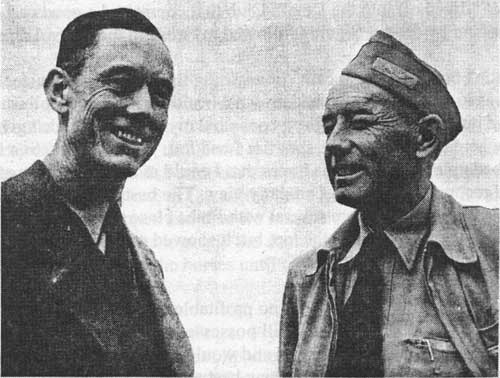
| Clarence Sutliff and Pilot Dick Johnson two weeks following the plane crash. |
|
|
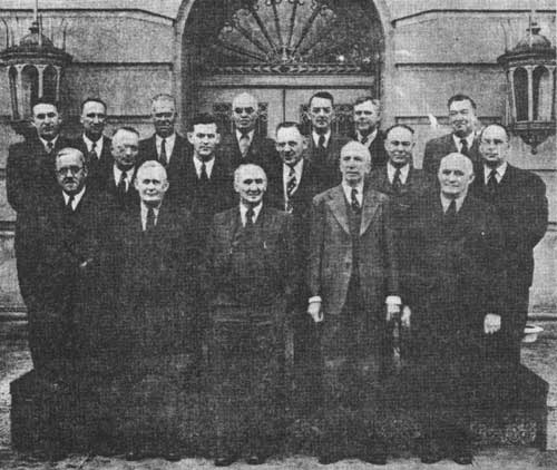
Forest Supervisors — January 1942 (In
meeting at Missoula, Montana) Left to Right: Back row: K.A. Klehm (Kootenai), J.C. Urquhart (Flathead), Ray R. Fitting (St. Joe), E.H. Myrick (Lolo), R.T. Ferguson (Lewis and Clark), G.M. Brandborg (Bitterroot), R.A. Phillips (Nezperce). Middle row: C.S. Crocker (Cabinet), C.C. Strong (Coeur d'Alene), P.E. Melis (Clearwater), J.E. Ryan (Kaniksu), A.N. Cochrell (Helena). Front row: A.H. Abbott (Gallatin), W.B. Willey (Beaverhead), J.N. Templer (Deerlodge), W.J. Derrick (Custer), G.E. Martin (Absaroka). |
| <<< Previous | <<< Contents>>> | Next >>> |
|
region/1/early_days/3/sec21.htm Last Updated: 15-Oct-2010 |