|
The National Forests of the Northern Region Living Legacy— |
|
Chapter 11
Roads, Trails, Ranger Stations, Lookouts, Support Structures, and Special Land Use
Human history, in the form of material remains of the past, is one of the resources recognized by Region 1. Not only do these "cultural" resources reflect the history of the uses of the forest lands, but the trails, roads, towers, and structures built by the Forest Service also demonstrate the changing infrastructure of regional forest management since 1908.
Most of the forests in the region already have sites listed in the National Register of Historic Places or are in the process of nominating structures or sites for inclusion. Among the more interesting and significant of these are Lochsa Ranger Station, Fenn Ranger Station, Hornet Peak Lookout, Nine Mile Remount Depot, and the Lolo Trail. National forests, ranger districts, and public-service organizations have all contributed to the preservation of the region's history.
Cultural or historical resources are administered under the general supervision of the cultural resources specialist assigned to each national forest. (Recent cuts in the budget have forced some neighboring forests to share these positions.) Forest plans provide for cultural resources management staffing to include archaeologist and historian positions. This chapter reviews some of the more important cultural and historical resources in the region and emphasizes yet another dimension of national forest management, mandated by Congress in such acts as the 1966 Historic Preservation Act and the 1979 Archaeological Resources Protection Act.
Roads
When the first forest reserves were created in 1891, most of the travel routes in the region were limited to rivers, trails, and wagon roads. Local residents and the Forest Service (after 1905) talked about the need for better roads, but little was done due to lack of funds. A Forest Service report prepared in 1910 became the catalyst for the movement to improve roads. That report emphasized fire protection as an imperative for the construction of more access roads in the region:
It has been accepted generally as true that one of the main reasons for the disastrous forest fires of the past season was that they started in inaccessible places or portions of the forests which were not regularly patrolled. Also, that had the Forest Service been given a sufficient amount of money for the construction of the necessary trails and telephone lines and for a better patrol, many of the fires would not have spread. [1]
Few roads were built during the first few decades of Forest Service management, and roads built by either the Forest Service or by loggers were little more than trails for the passage of mules and oxen. The "automobile age" and congressional highway funding began to provide access to Northern Region forests in the 1920's, but as late as 1945 many of the forested areas still were roadless. In 1921, Congress began to fund construction of highways that passed through the national forests, but it was not until the 1933-42 period, when the Civilian Conservation Corps was active, that extensive road construction was undertaken in the national forests in Region 1. The number of miles of roads in the national forests doubled during this decade. [2]
During World War II, some roads were built to aid in the war effort. For example, roads were built in the Beartooth Range in 1940-42 at elevations of up to 7,000 feet to aid in mining chrome deposits on the Custer National Forest. The Musselshell timber access road on the Clearwater was built in 1943 using local labor and Italian war internees. [3]
In 1952, Congress appropriated $22.5 million for road construction in the national forests. Region 1's share of this appropriation was approximately $4.25 million. During the 1950's, forest engineers upgraded many of the older roads and constructed new roads. By 1955, some 13,000 miles of improved roadways served the region; 30 years later there were some 31,000 miles, most maintained by the Forest Service. [4]
Roads designed, constructed, and maintained by the Forest Service fall into one of three categories:
1. Arterial roads—paved, two-lane roads designed to take heavy traffic at moderate speed (5 percent of Region 1 roads)
2. Collector roads—medium standard one-or two-lane all-weather roads used for access to timber or recreation (20 percent)
3. Local roads—minimum standard narrow, single-lane roads used for a specific purpose such as timber, grazing, electronic communication, dams, or fire control (75 percent) [5]
Roads exist or are built in the national forests to move people and resources. Interdisciplinary teams of Forest Service specialists plan the required transportation facilities and evaluate their effects on the environment. Before a road is constructed, a resource inventory of the area is made. Information and opinions are gathered from soil scientists, geologists, foresters, engineers, archaeologists, hydrologists, wildlife biologists, landscape architects, and others. Public involvement and opinion are sought throughout the project planning and decisionmaking process. [6] Environmental impact statements, required by the National Environmental Protection Act, are published for all road construction projects. Regional Forester Charles L. Tebbe in 1957 stated that the need for an adequate road system was critical to management of the 25 million acres of national forest land in Montana, northern Idaho, and northeast Washington. "Without access to land," Tebbe said, "the fruits of the land cannot be available to people; nor can the managers of land do an adequate job of protection, and care, and management". [7] But what once appeared to be a very forthright and reasoned statement of purpose has since been vigorously questioned.
Environmentalists now argue that "road construction is one of the biggest causes of environmental damage on the national forests. Erosion from the construction itself, with the use of heavy machinery, silts up streams and rivers, damages fish habitat, and degrades water quality." Moreover, "along with timbering and motorized access, roads can destroy wildlife habitat" for species such as bear, elk and "others that avoid [human contact]." [8] Although road construction may adversely affect wildlife habitat, it is generally essential for human access. Modern highways, and the ancient historic trails as well, reflect upon human uses of forest resources in the Northern Region.
Historic Roads and Trails
The Forest Service today administers a wide range of roads and trails for the public good. Many of these are both historic and scenic. One of the oldest roads is in the Sioux District of the Custer National Forest—the old Medora-Deadwood and Belle Fourche-Baker Stage routes, which crossed the grasslands in the 1870's and early 1880's. In some places, one may still see the ruts.
Highway 12, known as the Lewis and Clark Highway, runs across Montana and Idaho and parallels much of the historic Lolo Trail followed by the explorers. It provides a route through the Bitterroot Mountains via Lolo Pass and the major drainage basins. The Forest Service has provided picnic and camping grounds all along the highway. Motorists can stop and rest at the Lolo Pass Visitor Center or take a restful walk in the DeVoto Cedar Grove, which adjoins Haskell Creek, where the famous historian's ashes were spread. [9]
Highway 36 on the Flathead National Forest follows the shoreline of beautiful Hungry Horse Reservoir and provides access (via Highway 2) to Libby Dam on the Kootenai National Forest. The 63-mile Pintlar Scenic Route crosses high mountain passes and skirts ghost towns. The Beartooth Highway (U.S. 12 and 212), which crosses the rugged Beartooth Plateau on the Custer, Gallatin, and Shoshone National Forests, reaches the 10,942-foot Beartooth Summit, an "awe-inspiring, majestic mixture of rugged and natural beauty formed by the forces of nature." [10]
Approximately 20,000 miles of trails complement the more than 31,000 miles of roads of all classes in the forests and grasslands of the region. Together, the roads and trails provide access for fire protection and timber management on the one hand, and public recreational access for backpackers, hikers, cyclists, horse riders, fishermen, and hunters on the other. For winter sports enthusiasts, more than 2,300 miles of snowmobile trails (often using existing roads) are available. Modern trail development in the region combines the region's history with Forest Service recreational development. [11]
National Scenic, Historic, and Recreation Trails
In 1968, Congress passed and President Johnson signed the National Trails System Act (Public Law 90-543), which identified two classes of recreation trails: National Scenic Trails and National Recreation Trails. The original act was amended in 1972 (Public Law 94-527) to include a third category, National Historic Trails.
A National Scenic Trail was identified as "an extended trail located to provide maximum outdoor recreational opportunities and the conservation and enjoyment of nationally significant scenic, natural, or cultural values. National Recreation Trails are much shorter than Scenic Trails and are oriented primarily to urban people." [12]
Region 1 contains some of the better known National Historic, Scenic, and Recreational Trails, including the Continental Divide Trail, the Lewis and Clark Trail, and the Nez Perce Trail. All of the trails are joint undertakings of the Departments of Agriculture and the Interior, "in cooperation with affected Federal, State, and local governmental agencies, private corporations, interest groups, and individuals". [13]
The Continental Divide National Scenic Trail
Authorized by Congress in 1983, the Continental Divide Trail, which begins on the Canadian border in Glacier National Park and extends southward to the Mexican border, is being surveyed and developed. The Montana-Idaho segment was officially dedicated in June 1989. This segment wends its way past glaciers, snowcapped peaks, and waterfalls in Glacier National Park through the Bob Marshall and Anaconda-Pintler Wildernesses and portions of the Helena, Deerlodge, and Beaverhead National Forests of the Northern Region, to the scenic geysers and lakes of Yellowstone National Park. [14]
Nez Perce Trail
The Nez Perce Trail is identified in Public Law 94-527 as extending from the vicinity of Wallowa Lake, Oregon, to the Bear Paw Mountains in Montana. Including the Oregon portion, the trail, which commemorates the flight of Chief Joseph and the nontreaty Nez Perce Tribe in 1877, is 1,350 miles long. Approximately 210 miles of the trail are on national forest lands; about half of that is on the forests of Region 1.
The trail begins at White Bird, Idaho, where in June 1877 the Nez Perce elected to resist rather than to submit to confinement on reservations. They first fled north, to Musselshell Meadow on what is now Clearwater National Forest. Then, following the Lolo and historic Nez Perce Trail across the Clearwater, they left Idaho via the Lolo Pass. In Montana, the tribe stopped for a time on what is now Lolo National Forest. Moving south, they crossed the Continental Divide, entering what is now Beaverhead National Forest, fought the Battle of Big Hole, and moved through the Yellowstone area and then northward toward Billings, Montana, where they surrendered on October 5, 1877, to U.S. forces under Col. Nelson A. Miles. [15]
The Lewis and Clark National Historic Trail
When the original National Trails System Act was passed in 1968, the Lewis and Clark Trail was not included. Congress had, however, in 1964, enacted Public Law 88-630, which established the Lewis and Clark Commission. An amendment to the National Trails System Act, approved in 1972, authorized the Lewis and Clark National Historic Trail. In 1979, the trail was officially sanctioned. [16]
The Lewis and Clark expedition began on May 14, 1804, when the explorers "headed their boats into the current of the river under a jentle brease." Thus began a journey of 2 years, 4 months, and 9 days, covering almost 8,000 miles and reaching across the unexplored continent to the Pacific coast and back to St. Louis, Missouri. The expedition first entered land now designated national forest at a point Lewis called, on July 19, 1805, "Gates of the Rocky Mountains," located northeast of Helena, Montana, on what is now the Helena National Forest. Moving southward, the expedition entered what is now the Beaverhead National Forest and continued southwest, crossing the Continental Divide at Lemhi Pass and entering what is now the Salmon National Forest in Idaho. On August 12, 1805, Lewis reported "a handsome bold running creek of cold clear water. Here I first tasted the waters of the great Columbia River." The expedition turned north and eventually crossed the Continental Divide at Lost Trail Pass, reentering Montana and the present-day Bitterroot National Forest. [17]
Moving northward across the southern part of the Bitterroot area, the expedition entered the Bitterroot Valley. When they reached its northern end, just south of the present town of Lolo, they spent several days at Travelers Rest. (The expedition would stop here again on its return.) Historians disagree on the location of the camp, but Ralph Space, who probably has studied the historic trail more than any other in the region, believes the stop was on Lolo Creek, just west of the present town of Lolo. [18]
The travelers rested for three days, and on September 11, 1805, moved from Lolo Creek onto the Lolo Trail. They visited Lolo Hot Springs, where Lewis tasted the water and "found it to be not bad." Pressing westward, the expedition crossed the Bitterroot Mountains near Lolo Pass and entered today's Clearwater National Forest in Idaho, where they rested in a half-mile-wide valley with good grass, called Glade Creek (now Packer Meadow). [19]
The expedition now entered some of the most difficult terrain it had encountered since leaving St. Louis. They reached the headwaters of the Lochsa River, which they called Koos Koos Ke, and camped in an open meadow where the Powell Ranger Station would one day be built. Crossing this rugged area, the travelers were cold and hungry most of the time. Among their camps and rests were Wendover, Snowbank Camp, Spring Mount, Sinque Hole, and Dry Camp. All of the diaries of the expedition speak of the cold, deep snow and the steep, rocky pathway often blocked by fire-killed and wind-fallen timber. [20]
The trail became worse due to increasing cold and snow. Stops were made at Horse Sweat Pass, Hungry Creek, Portable Soup Camp, and Lewis and Clark Grove. Finally, on September 20, the expedition dropped down from the mountains, near Weippe Prairie. Here, on what is now the Clearwater National Forest, they met the Nez Perce Tribe, and then continued on toward the Pacific Ocean. On the return trip in 1806, the expedition would retrace the Lolo Trail back to Travelers Rest. From there, they would return to the Missouri River by a new route. [21]
Over the years a number of Forest Service personnel have made efforts to mark the original trail. Ralph Space traced much of it through the Clearwater National Forest in the 1920's and 1930's. It took Space and his son an entire day to merely trace one and a half miles of the old trail. Space feels that in the intervening years, much of the physical evidence of the original trail has been obliterated. [22]
In the past 5 years, Clearwater National Forest staff have scouted and flagged almost all of the original trail across the forest. "Take Pride in America" programs organized by the Forest in the years since 1988 have resulted in more than 650 person-days of volunteer labor that has cleared, marked, and maintained several miles of the route. In the next 5 years, they plan to have opened a route on which one can still walk in the indented path that perhaps Lewis and Clark themselves trod.
The Lewis and Clark expedition "crossed mountains that had no highways, floated rivers that had no dams, saw buffalo that had no limits, talked with Indians that had no masters. They were the first!" Contrast their trek with that of present day travelers who "...follow the explorers' footsteps across the West in mobile homes with ice makers, air conditioners, and hot showers." [23] Although the world has indeed changed since the days of Lewis and Clark, it is fitting that the National Historic Trails and the Scenic and Recreational Trails enable modern travelers to share the rich heritage of the Northern Region. Somewhat less historic in terms of elapsed time, but significant as evidence of the history of forest management in the Northern Region, are the pioneer ranger stations, lookout towers, and logging and mining structures that survive.
Ranger Stations, Work Centers, and Other Structures and Installations
What is believed to be the oldest ranger station in the Forest Service, and certainly in Region 1, is located on the Bitterroot National Forest. Alta Ranger Station, as it is called, was built in 1899 by pioneer rangers Nathanial Wilkerson and Henry C. Tuttle, who paid for the materials from personal funds that were never reimbursed. This sturdy 13 by 15 foot, one-story log cabin served as a ranger station for 5 years. (The Hughes Creek area, where the cabin was located, flourished with the discovery of gold in 1900, but the strike played out in a few years and the station was closed. It was also discovered that the building stood on private land.) In 1904, it was sold to a private owner, who moved it to Darby. [24]
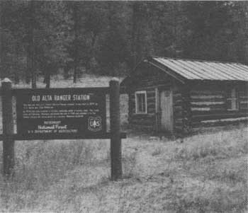
|
| Alta Ranger Station as it appears today. |
Abandoned, the Alta Ranger Station would have gone the way of most derelict buildings. The Hamilton, Montana, Lions Club, however, decided to preserve and restore the building. In 1941 they purchased the site of the original ranger station, moved the restored cabin to the original site, and deeded both to the Forest Service. Unfortunately, the building again fell into disuse and neglect as described by a newspaper article in 1959:
Only the packrats scurry among the old newspapers and magazines that litter the floor now, and a few window panes are broken out, but the day may come when the old landmark will be something of an official monument to pioneer foresters who had such a personal interest in protecting the nation's forests that they were willing to sacrifice much of their own time, comfort and meager funds. [25]
Awakening interest in historic building preservation in the 1960's led to the restoration and renovation of the Alta Ranger Station. It has been listed in the National Register of Historic Places and receives regular financial support from the Forest Service and private philanthropists alike.
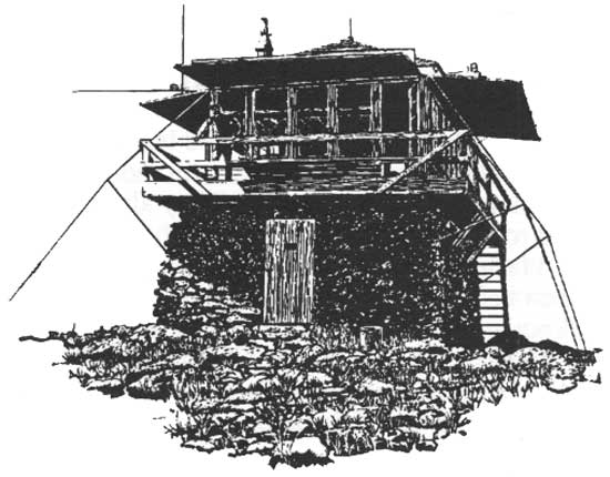
The Alta Ranger Station is not atypical of those used by rangers well into the 1930's. At that time, ranger stations varied from simple log cabins like Alta to more modern work centers with well-built homes and administrative offices. As ranger districts became consolidated, the older and more remote cabins still were used for small crews to live in and work out of on a temporary basis. A more modern ranger station might include cabins, storage sheds, and work centers radiating out from the station itself. More isolated and less important facilities might include little more than a shed or a barn and corral for the horses and mules. Still others, like Lochsa Ranger Station on the Clearwater National Forest in Idaho, were almost small towns. Highway 12 reached Lochsa in 1953 and was opened to through travel to the Powell Ranger Station in 1960.
Lochsa was established in 1926, when a log structure was moved from Boulder Flat on the Lochsa River and reassembled on a new site about a mile down river. A cabin was built in 1928, and an alternate dwelling, the site of the present visitor center, was built in 1931. A second ranger station, which replaced the first cabin, was completed in 1933. About 8 acres were cleared around the station to provide a hay meadow for the animals; in 1934, "as flames raged around and overhead," that clearing saved the lives of more than 200 people. [26]
|
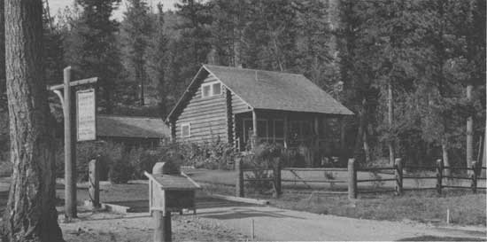
| West Fork Ranger Station, Bitterroot National Forest, Darby, Montana. 1941. |
The Lochsa Ranger Station also boasted an elaborate root cellar, which maintained a fairly constant temperature in both summer and winter for the storage of root vegetables and other perishable foods. Eventually, in addition to those structures already mentioned, there were toolsheds, a tack room, an office, a commissary, a tool room, storage sheds, and a kitchen for the bunkhouse. Until the 1950's, all of this was maintained and supplied by strings of horses and mules. [27]
The Lochsa era came to a close when Highway 12 penetrated the region. The district headquarters was relocated to Kooskia, Idaho, in 1956. As more and more roads entered the more isolated parts of the region, the Forest Service began to abandon or downplay such places and operate out of more centrally located centers. In 1976, the Lochsa Historical Ranger Station was established by the Forest Service "as a memorial to the history of the Forest Service efforts to bring management to the National Forests." It is listed in the National Register of Historic Places. [28]
At Lochsa, visitors can enter the ranger's home and marvel that the furniture, including a Victrola and a 375-pound cast-iron bathtub, was all packed in by horses. The dining table is set with the durable but still aesthetically pleasing Forest Service issue pottery and china (donated by retired Forest Service personnel and their families). Entering the buildings is like stepping back into the early 20th century. Future generations will be able to have a brief glimpse of what life was like in a less complex time. [29] In the early 1900's, the Forest Service developed a rather elaborate system for establishing ranger stations and other required buildings, from the selection of the site to the type, style, construction, and number of buildings desired. For example, in 1908 a report issued for the proposed Sleeping Child Ranger Station on the Bitterroot National Forest contained complete plans, specifications, diagrams, and maps. [30]
Clyde P. Fickes completed another series of reports between 1936 and 1939, evaluating new sites and plans as well as reporting on the condition and value of those already operating on the Deerlodge, Custer, and Kootenai. [31]
The age of the automobile and completion of roads into previously remote forested areas brought changes in the size and location of ranger district headquarters and support structures. The older structures were often built to last. Many survive today, and these are now being protected and preserved as a part of the cultural heritage of the Northern Region.
For example, the Forest Service is cooperating with State agencies and the private sector to preserve the Bull River Ranger Station on the Kootenai National Forest. Built in 1908, this station operated until 1920. It then served as a guard station until 1966. The Montana Historical Society in 1987 urged preservation of the Bull River Ranger Station, which has since been entered in the National Register of Historic Places. [32] The region recently awarded a contract for evaluation of Bull River's historic structures for nomination to the National Register and protection or renovation as may be advised.
Slate Creek, Big Prairie, and Fenn Ranger Station and Vigilante Work Center
One of the more important sites already protected and preserved by the Forest Service is the Slate Creek Ranger Station. Built in 1909 on the Nez Perce, it was relocated to a more desirable spot in 1975, completely reworked, and furnished by retired Forest Service employees.
Big Prairie Ranger Station on the Flathead, established in 1904, has surviving structures dating from 1930 that have been in continuous use since that time. The station is now in the heart of the Bob Marshall Wilderness. [33]
The first log structure of the Vigilante Work Center was built in 1925, and other buildings were added in following years. In 1957, the supervisor of the Beaverhead first raised the question of ultimate disposition of the outdated facilities. Later evaluations concluded that the station should be kept and preserved as funds permitted. [34]
Fenn Ranger Station, built by the Civilian Conservation Corps in the 1930's and named for Major Frank A. Fenn, the first supervisor of the Selway, is considered "one of the Forest Service's classic stations." [35]
Aerial Fire Depot
The Aerial Fire Depot, located outside Missoula, Montana, is the largest single physical plant in the Northern Region. It is devoted to the control of forest fires through use of airplanes and smokejumpers. The visitor center at the depot features a reconstructed fire tower and other displays explaining how forest fires are caused and fought. Also located here is the Intermountain Fire Sciences Laboratory, a weather science unit, and the Northern Training Center—a cooperative effort of the Forest Service; the States of Montana, Idaho, and North Dakota; and other Federal agencies. Supplies to maintain 5,000 firefighters in the field for 48 hours are stored here. Helicopters and aircraft for use in reconnaissance, smokejumping, and transport are available, as are large quantities of fire-retardant chemicals. [36]
|
| Beds at Savenac Nursery. Couer d'Alene National Forest. Photo by K.D. Swan. |
Savenac Nursery
Over the years, Region 1 has established and operated a number of tree nurseries. One example is the Savenac Nursery, which has operated continuously since being established in 1909 near Haugen, Montana. (The facility was totally destroyed by the great fire of 1910 but was rebuilt in 1911.) In 1933, Camp Taft was built nearby to house the Civilian Conservation Corps (CCC), marking a new era for the nursery as the CCC completely rebuilt, enlarged, and landscaped the facility. In 1969, nursery operations were transferred to Coeur d'Alene, Idaho, and the Lolo National Forest assumed responsibility for administration of Savenac. The complex consists of nine buildings and two fine stone bridges dating from the 1920's. While the CCC was providing labor, extensive plantings were made in the arboretum (begun in 1916), which today provides a beautiful area for botanical observations. [37]
Fort Missoula Historical Museum
The historical museum at Fort Missoula, Montana, is another cooperative endeavor supported by the Forest Service. The Service maintains a forestry interpretive area that includes a restored 1910 guard cabin; a 1934 L-4 type lookout tower, from Little Sliderock Mountain; a railroad logging spur with a steam-powered Shay engine that was in use until 1949; and other displays. The Missoula Chapter of the Society of American Foresters, the Friends of the Museum, Champion International, and other public and private agencies cooperate with the Forest Service in managing the museum and developing its interpretative programs. The Lolo National Forest is headquartered in one of the buildings of old Fort Missoula, itself of historic interest. [38]
Logging Remnants
Many structures and artifacts on national forest lands have become historic resources of the early logging practices discussed in Chapter 3. Some of the more interesting structures in the Northern Region are the log chutes and dams of northern Idaho and western Montana. The St. Joe National Forest, for example, has splash dams, steam donkeys, log chutes, flumes, and an incline railroad.
Extensive historical and archaeological investigations have been conducted to determine the exact manner in which the chutes were operated and their period of operation have been conducted. Hundreds of miles of old log chutes are in varying stages of decay. Splash dams for impounding water to operate some of the chutes still exist, and donkey steam engines used to haul logs to the site are still in place in some instances. Most of the chutes date from the 1910-30 period, although some—such as one on Fall Creek near the old Shiloh Ranger Station on the Kaniksu—operated into the 1950's. One of the best-preserved log chutes is located at Sheep Creek at Little Belt Mountain on the Lewis and Clark National Forest in Montana. [39]
Remount Depot
Other than foot, horses and mules were the only means of traversing the forests in the early days, and they remained important well into the 20th century. Over the years, the Forest Service slowly developed a planned system of transportation and "an elaborate trail system began to grow through the roadless, timbered mountains." [40] The automobile was introduced before World War I, but was not common until the late 1920's. Even though the car and truck were available, large expanses of the region remained roadless until after 1945, and animal transportation continued to play a vital role in supplying isolated units and fighting forest fires. The automobile, airplane, and helicopter have almost brought the day of the horse and mule to a close, although animals remain the principal means of transportation in wilderness areas.
The horse and mule were still very important in 1930, when the regional forester authorized establishment of the Remount Depot on Nine-Mile Creek near Missoula, Montana, for the training, breeding, care, and stabling of horses and mules. Ranger Clyde P. Fickes was placed in charge of the depot and instructed to collect and train animals to meet the needs of Region 1 and adjoining regions. Fickes and his crew of experts experimented with horses and mules and decided that mules, known as Rocky Mountain canaries, were tougher and more reliable. "Mules were preferred for packing as they were more careful to avoid bumping their packs into trees along the trail," and mules simply were more surefooted and could carry greater loads than horses. Fickes also discarded the old "saw buck" and the "diamondhitch" in favor of the Idaho Decker Packsaddle, developed by O.F. Robinette and the Decker brothers near Kooskia, Idaho. This saddle allowed each animal to carry larger and heavier loads. [41] The Remount Depot was a complete center for breeding, training, and dispatching animals, training packers for wherever they might be needed; and for manufacturing and repairing the necessary equipment. Fickes and his team, Jane Benson said, "proved that a string of nine mules with more than a ton of supplies on their collective backs could form a solid basis of supply for firefighters controlling forest fires." [42]
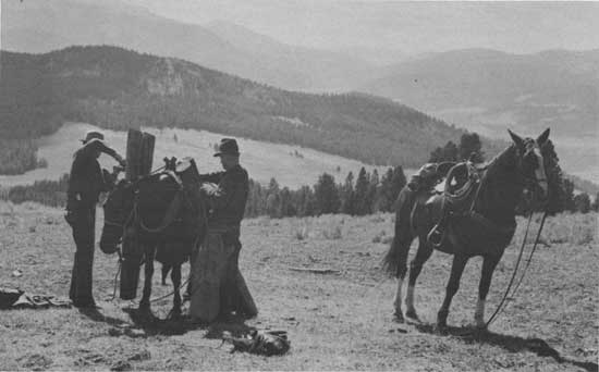
|
| Unpacking horses. Beaverhead National Forest, 1945. |
In 1933, the Civilian Conservation Corps established Nine-Mile Camp near the Remount Depot and thereafter did much of the work on and around the depot. By the fall of 1935 they had cleared the surrounding land for pastures, cut poles, and built miles of fence to enclose the entire unit. During this period the first training of smokejumpers, bailing out of Ford Tri-Motor planes, took place in the CCC hayfields. Later, the CCC built the large barn that still stands, a cookhouse, and a number of cabins and other buildings in a distinctive Cape Cod style of architecture. [43]
Following World War II, the feasibility of continued operation of the Remount Depot was discussed, but no clear-cut verdict was reached. Many felt that the horse and mule still had a role to play in fire control, and as late as 1953 some 13 strings still operated in the field; however, some felt that the depot had served its purpose. Because the cost of operating the depot was constantly increasing, its phasing out soon began. [44]
Fortunately, the depot continued to be occupied for various Forest Service projects, and most of the buildings were kept in good repair. As the Forest Service developed more awareness of the public trust it held in the care and preservation of cultural resources, even more attention was given to preserving the Remount Depot as a historical entity.
Because most of the Remount Depot structures were built during the middle 1930's, they began to approach the required 50 years of age that would merit their consideration for inclusion in the National Register of Historic Places in the late 1970's. Beginning in 1978, the Lolo National Forest began to survey and gather documentation about the buildings in preparation for submission to the National Register. The submission was accepted in 1980. In keeping with the American public's increasing consciousness of the value of the past, plans have been made to reopen the facility as a living museum in the tradition of Colonial Williamsburg, Virginia. One of the more exciting and interesting aspects of the project will be the training of a working packstring of mules that also could visit such gatherings as parades, county fairs, and rodeos, providing today's citizens a better understanding of the past. A specially designed and painted trailer for the mules has been purchased to transport the mule string. [45]
Fire Lookouts
The greatest danger to all forests is the natural disaster of fire. In earlier times, fires were largely caused by lightning, which remains the major fire-causing agent; however, in more recent years it is increasingly common for a fire to be manmade. Even when the forests in the region were still Forest Reserves, prevention and control of fires received attention, but it was not until the Forest Service was created that a planned, orderly approach to fire control was inaugurated.
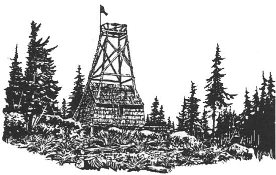
During the latter part of the 19th century and the early 20th century, a lookout was merely an observation post established on a high point with an unrestricted view. The evolution of the famous Hornet Peak Lookout on the Flathead shows the development of these isolated outposts. Hornet Peak began as a high-ground observation post. In 1917, it was a crude pole tower and a cabin. The present structure, a D.L. Beatty "D-1" standard lookout house with a church-like tower, was erected in 1922. [46] Hornet Lookout is a classic example of the era when Forest Service pioneers hand-carved every bridge, barn, corral, and cabin out of the woods around them, using only crosscut saws to fell and buck the logs, and mule teams to drag each one into place. With a broad ax they hewed and fitted the corners; and with a froe they hand-split each shingle to match the rest. [47]
Everything not obtained from the Hornet Lookout site was hauled by mule strings 35 miles by trail up the North Fork of the Flathead River from Columbia Falls, Montana. Even today a four-wheel drive vehicle and a good hike are required to visit the cabin. When one stands at the lookout, it is quickly evident why its site was chosen—the beautiful view encompasses Glacier National Park, Kintla Lake, and even the Canadian Rockies in the distance. [48]
Typical furnishings of fire lookouts are much like those on the Clearwater National Forest, described by Linnea Keating and Karl Roenke. "Prior to the 1920's," they said, "a lookout site possibly consisted of a tree platform (crow's nest) and/or alidade table (map board), a tent camp, and the lookout person." Other equipment besides the tent would be a pair of binoculars, maps of the adjacent areas, and storage facilities for food and water. Early lookouts were expected to extinguish small blazes on their own or in the case of a larger one ride for help. After 1910, telephone lines were run from each lookout to a central clearing headquarters, allowing a much faster reporting and response. [49]
A number of the region's lookouts have recorded some of their early experiences. Norm Schappacher, for example, served as a lookout on the Flathead from 1930 to 1937. His first assignment, Tally Lake, was simply a topped tree and a tent. Schappacher received $65 a month plus room and board, and as he remarked, "Board tended to be canned government rations," which varied from excellent for the butter to terrible for the bread. [50]
Most lookouts seem to remember fondly their time spent in the forests, although all agree it was lonely work. Due to the shortage of men during World War II, many women served as lookouts. Harriet Linn spent the war years at Thompson Lookout on the Lolo and considered smoke-spotting her contribution to the war effort. Her lookout, she recalled, had a hardwood floor, built-in cabinets and table, and apple-green woodwork. [51]
Another firsthand account of the life of the lookout comes from Walter L. Robb, who described the construction of Thompson Lookout:
The tower was built in 1934 from a L-4 cabin package milled in Columbia Falls. Materials were packed by mule to the site and raised on legs cut on Thompson Peak. A horse and "ginpole" rigging were used to raise the tower. [52] The Thompson Lookout later had to be closed and torn down because it became unsafe due to age and vandalism.
Fern Bonnell, interviewed in 1982 by C. Milo McLeod about her 12-year career as a spotter, recalled her work as a relaxing and educational interlude away from her public school duties from 1943 to 1955. She described lookout responsibilities, "which included weather observation, fire detection and location, and playing good host to visitors." She was more fortunate than many lookouts because her tower had an air traffic beacon that required electricity and allowed the use of a refrigerator. [53]
When the Civilian Conservation Corps became active in 1933, the heyday of the lookout had arrived. Using this almost inexhaustible source of both skilled and unskilled labor, the Forest Service began to replace archaic lookouts with more elaborate structures and rather comfortable cabins. They also upgraded paths, trails, and roads serving the lookouts, which allowed for much easier and faster communication and resupply. One of the better known and best preserved lookouts built by the CCC is Tri-point Lookout and Station on the Beaverhead. Built in 1940, it consists of a wooden lookout tower and log cabin. Well maintained and modernized, it is in excellent condition and will continue to be used as an active lookout. [54]
Porphyry Peak Lookout on Kings Hill Pass, just west of Highway 89 on the Lewis and Clark, also is well preserved and considered to be one of the finest examples in the region. The CCC did extensive work on this structure during the 1930's. [55]
The Forest Service experimented with many different construction plans for lookouts. A few steel-girder lookouts were built, but the cost proved prohibitive, especially when wooden poles cost only the labor required to fell and emplace them. The peak year for the operation of fixed lookouts in the region was 1938, when some 800 lookouts were in operation. The number declined to 250 in 1964, and only 85 were in service in 1987. [56] Satellite surveillance and modern electronic technology have displaced most of the manned fire lookout posts, but those surviving remind us of the role that fire has played and continues to play in the history of the Northern Region. In recent years, some of the fixed fire lookout towers still in good repair and reasonably accessible have been made available, as have some of the unused ranger and guard cabins, for rental to the public. The Northern Region's innovative recreational rental program has thus far been successful. [57]
Communications
Before 1910, few telephones were in operation in the Northern Region. The first was strung to Iron Mine in 1905. However, the devastating fire of 1910 emphasized the immediate need for more rapid communications. To meet this need, wire in the form of a single-wire grounded circuit was purchased and quickly strung by simply attaching insulators to standing trees. The Civilian Conservation Corps began to string thousands of miles of metallic (No. 2) wire line into even remote parts of the forests in 1933. [58]
A notable early example of individual forest communication was on the Nez Perce, where the CCC helped to string a 125-mile circuit. The peak year for telephone usage was 1948, with 12,650 miles of wire, but thereafter mileage began to rapidly decline as radio and private telephone services replaced Forest Service lines. Some of the unused lines were sold to local residents, but most of the wire remained in the forests. The region began a program to remove the wire because it was dangerous and unsightly. [59] A number of forest reports in the 1950's include information on the progress of wire removal and the conversion to radio, but by the end of the next decade lines owned by the Forest Service had become so insignificant that they were no longer being considered in official reports.
In the pre-telephone era, the Forest Service experimented with a variety of communication devices. One of these was the heliograph, a signal device relying on mirror flashes. It seems that Forest Service personnel universally cursed the machine. Red Stewart, who operated heliograph devices from the Mallard Peak Lookout in 1915, termed it "an invention of the devil." [60] The radio, introduced into the Northern Region in 1919, quickly displaced the heliograph.
Historical records indicate that the first use of radio communication in the Northern Region was in 1919, but it did not become widely used until after 1930. In 1933, 59 radio sets of varying power and dependability were in use, and the next year 43 additional two-way radio sets were in service. The Forest Service established a Radio Laboratory in Portland, Oregon, to improve radio communications systems. The laboratory designed the "M" set, the SPF semiportable, and a smaller unit that the Forest Service had specially manufactured for its use because comparable commercial units were not then available. After World War II, the Forest Service adopted the radio as its primary means of communication, hastening the decline of the field telephone. Very soon, radio towers appeared on the forests, providing better transmission into and across the forests. Those simple towers have now been joined by highly complex electronic centers for transmission of television and satellite signals. [61]
Modern transportation and communications, characterized by the automobile, airplanes, the telephone, radio, and television, have not only improved the processes of national forest management, but they have also greatly widened the rank and file of forest resource users in the Northern Region. The "outside" world became much more conscious of the scenic, recreational, and economic attributes of the national forests in the decades following World War II. This phenomenon contributed in part to the fact that resource management by Federal agencies increasingly came under the scrutiny of many diverse and often geographically remote interest or "user" groups. That new condition of management became clearly evident in the Forest Service, and in Region 1, near the end of the 1960's.
Reference Notes
1. A.F. Potter, Associate Forester "Appropriation Estimates," November 18, 1910, Federal Records Center, Seattle, WA, Box 99-77-0315/1 of 7.
2. Press Release, Region 1, #1095, April 23, 1952; U.S. Department of Commerce, Office of the Secretary, Washington, D.C., Federal Records Center, Seattle, WA, Box 85-69F081 13/3.
3. F. Hamblet, Typescript Memoirs, Region 1 historic files, Missoula, MT.
4. National Forest Landscape Management, volume II, Roads (Washington, D.C.: Government Printing Office, 19—), p. 2; "Report on Inspection, 1955," Federal Records Center, Seattle, WA, Box 42900, Item 1-14, p. 5.
5. U.S. Department of Agriculture, Forest Service, Roads in the National Forests (Washington, D.C.: USDA Forest Service, 1988), FS 414, p. 9.
6. Ibid., pp. 4-12. Environmental impact statements, required by the National Environmental Protection Act, are published for all road construction projects.
7. Report by H.R. Jones, Engineer, and W.L. Morris, Supervising Highway Engineer, 1955, p. 2; Charles L. Tebbe, Memorandum on Roads, Missoula, MT, December 14, 1957, Region 1 historical files.
8. Peter C. Kirby and Robert W. Tutnage, "Two visions of the National Forests' Future," House Subcommittee on Forests, Family Farms, and Energy, 1986.
9. Sioux Planning Unit "Final Environmental Statement" Custer National Forest (Billings, MT: Region 1, Custer National Forest, 1976), 129 pp., see especially pp. 1-2; Northern Region National Forests and Grasslands Outdoor Recreation Guide (Washington, D.C.: Government Printing Office, 1984), R1-72-031, Rev. 84, folded brochure.
13. Nez Perce (Nee-Me-Poo) National Historic Trail Study,—Public Workshop Information Packet, November 1978, p. 1, Intaglio Collection, University of Montana Archives, Missoula, MT.
14. Continental Divide Trail (Washington, D.C.: Government Printing Office, 1983), FS 6200-7, 10/73, pp. 7, 9-13.
15. Nez Perce (Nee-Me-Poo) Trail,— October 1978, Beaverhead National Forest, historic files, p. 1; National Park Public Information Brochure, "Nez Perce National Historic Park," 1984; "Nez Perce National Historic Trail Study," p. 3, Intaglio Collection, University of Montana Archives.
16. Lewis and Clark Trail Commission, "The Lewis and Clark Trail: A Challenge for the Future," by Sherry F. Fisher, Chairman, typed, Fort Worth Regional Archives, Fort Worth, Texas, Box 77-031514; Douglas A. Prchal, "The Lewis and Clark Trail: A Site Selection Proposal for Interpretation in Montana," M.A. Thesis, Iowa State University, 1981, Beaverhead National Forest historic files, pp. 4-6.
17. U.S. Department of the Interior, National Park Service, Lewis and Clark Trail, 1988, folded brochure; Prchal, "The Lewis and Clark Trail," p. 13; Bernard DeVoto, ed., The Journals of Lewis and Clark (Boston: Houghton Mifflin Company, 1953), 504 pp., pp. 189-233.
18. DeVoto, Journals of Lewis and Clark, pp. 189-233; Ralph A. Space, The Lolo Trail (Lewiston, Idaho: 1984), 67 pp., p. 4.
19. Dan Murphy, Lewis and Clark: Voyage of Discovery (Las Vegas, Nevada: K.C. Publications, 1977), n.p.
20. USDA Forest Service, Northern Region, Following Lewis and Clark Across the Clearwater National Forest (Washington, D.C.: Government Printing Office, 1982), brochure, and see "Visitors Guide," Clearwater National Forest; DeVoto, Journals of Lewis and Clark, p. 239.
22. Interview, Victor H. Treat with Ralph S. Space, Orofino, ID, August 15, 1988.
23. David Lamb, "Lewis and Clark," The Houston Chronicle (March 5, 1989); Murphy, Lewis and Clark, epilogue.
24. "The Beginning: First Ranger Station" Western Outdoors (1988), p. 75.
25. Peyton Moncure, "The Alta Ranger Station," Salt Lake Tribune, Home Magazine (October 4, 1959).
26. "Lochsa Historical Ranger Station," Clearwater National Forest, folded brochure.
29. Ibid.; Treat interview with Gordon Hawkins, Sr., August 14, 1988.
30. "Report on Proposed Administrative Site," June 27, 1908, Seattle Archives, Box 49051, Item 12, p. 8; Inspection Report, May 11, 1936, historic files, Deerlodge National Forest
31. Montana Historical Society, State Historic Preservation Office, "Report," Helena, MT, 1987.
33. Focus, Flathead National Forest, 1988.
34. Memorandum, Beaverhead National Forest historic files (7300), 1957, 1965, 1968.
35. Neal Parsell, Major Fenn's Country (Grangeville, ID: Central Idaho Offset, 1986), pp. 2-43.
36. Elers Koch, Forty Years a Forester (Missoula, MT: USDA Forest Service, Region 1, n.d.), pp. 29, 1-173.
37. "National Register of Historic Places," Nomination Form, Region 1 historical files, 1983.
38. Historical Museum, Fort Missoula, Missoula, MT. folded brochure (R1-80-23, Rev. 86).
39. Cort Sims, Cultural Resources: The Log Chutes of North Idaho, Report No. 8, Idaho Panhandle National Forests, 1983, pp 1-97; George C. Knight, Cultural Resources: Testing Archeological Inference at an Historical Logging Site in Montana, Report No. 1, Idaho Panhandle National Forest, 1981, p. 88, p. v.
40. Jane R. Benson, Thirty-Two Years in the Mule Business (Lolo National Forest: Washington, D.C., Government Printing Office, 1982), pp. 1-40.
41. Ibid., Preface, p. 5; "Focus," Flathead National Forest(1987), p. 4.
43. Benson, Thirty-Two Years, p. 14.
45. Interview, Victor Treat with Robert Hoverson, Remount Station, August 12, 1988; Michael Korn, "Ninemile Mules," Montana Magazine, (July-August 1988), pp. 40-41.
46. Larry Wilson, "Volunteers Saved Historic Building," in Hungry Horse News (August 17, 1986).
47. Petition, National Register of Historic Places, 1983, Flathead National Forest, Kalispell, MT.
48. Interview, Victor H. Treat with archaeologist Gary McLean, Flathead National Forest, Kalispell, MT, August 9, 1988.
49. Linnea Keating and Karl Roenke, Fixed Fire Detection Lookout History on the Clearwater National Forest, Idaho (Orofino, ID: Clearwater National Forest, 1987), n.p. For good descriptions of the various styles see also Ray Kresek, Fire Lookouts of the Northwest (Fairfield, WA: Ye Galleon Press, 1984, Rev. 1985), pp. 1-412, and C. Milo McLeod, "Lookouts on the Lolo National Forest," historical files, Bitterroot National Forest and Lolo National Forest
50. Bob Chaney, "Lightning, Forest Remain Part of Lookout's Life," Hungry Horse News (December 9, 1987).
51. Harriet Linn, "Memoirs of Thompson Lookout," typed manuscript, dated March 1944, in Federal Records Center, Seattle, WA, Box 095-67-0750.
52. Interview, C. Milo McLeod with Walter Robb, 1982, Lolo National Forest historic files.
53. Interview, C. Milo McLeod with Fern Bonnell, February 2, 1982, Lolo National Forest historical files.
54. Memorandum, September 24, 1984, (2360), in Region 1 historical files.
56. Ibid.; Memorandum, "Lookouts Summer 1985," historical files, Beaverhead National Forest
57. USDA Forest Service, Northern Region, "Northern Region: Recreational Cabin and Lookout Directory," 1988.
58. J.H. Coats, Communications in the National Forests of the Northern Region: A History of Telephone and Radio (Missoula, MT: USDA Forest Service, Northern Region, 1984), pp. 1-60; and see Gary Craven Gray, Radio for the Fireline: A History of Electronic Communication in the Forest Service, 1905-1975 (USDA Forest Service: Washington, D.C., Government Printing Office, March 1982), FS 369.
61. Ibid., pp. 1-60; and see Gray, Radio for the Fireline.
| <<< Previous | <<< Contents>>> | Next >>> |
|
history/chap11.htm Last Updated: 10-Sep-2008 |