|
The Nezperce Story A History of the Nezperce National Forest |
|
THE FOREST ESTABLISHED
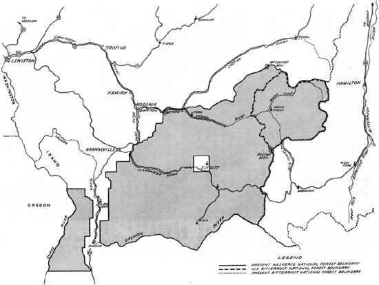
Proclamation-wise the present Nezperce National Forest developed as follows:
February 22, 1897. Bitterroot Forest Reserve. The west boundary then ran north between Ranges 5 and 6E from just below the mouth of Sheep Creek on Salmon River across the divide near the head of 10-Mile Creek and the South Fork about the mouth of 10-Mile Creek, over Corrall Hill and to the Middle Fork at about the present boundary.
November 14, 1902. Addition to Bitterroot Forest Reserve, This extended the boundary westward to its present location.
November 14, 1902. Little Salmon Forest Reserve.
February 1, 1904, Seven Devils Forest Reserve.
June 14, 1904, The Elk City Township and a smaller area around Buffalo Hump were eliminated from the forest.
May 10, 1906, Weiser National Forest.
July 1, 1908, The Nezperce National Forest was created.
July 9, 1921, The Buffalo Hump exclusion was again given national forest status.
April 7, 1931, The Salmon Mt. area was placed in the Bitterroot, although it had been administered by that forest since the season of 1917.
October 29, 1934. A portion of the Selway came to the Nezperce.
July 1, 1956, The Moose Creek District was added to the Nezperce, and the area north of the Middle Fork plus the Lochsa drainage went to the Clearwater.
Major F. A. Fenn stated that, between the Bitterroot and Nezperce stages, the area was a part of the Clearwater Forest. This is not in accord with the above, although there could be a missing link in the forest files.
***
The Little Salmon and Seven Devils Reserves were small and soon became a part of the Weiser. The portion of that forest which was made a part of the Nezperce lay between the Salmon and Snake Rivers. For years this was referred to as the "Weiser Division," but is now more commonly called the "Island Division."
The Leiberg report describes the Idaho portion of the Bitterroot Forest Reserve as follows:
The Clearwater drainage consists of a number of large forks or tributaries, which divide into an intricate system long and short canyons, mostly narrow and winding. Its main arteries are North, Middle, Lochsa, Selway, and South Forks. The Canyon system, of which these affluents form the main trunks, is by far the most noteworthy and striking feature in the topography of the Clearwater basins. Its windings and ramifications are great.
The western slope of the Bitterroot Mountain is primarily formed by a few great branches from the main range, which in their turn branch out into a vast mass of curving, winding, peak-crowned spurs constituting the watersheds of the Clearwater basins.... The primary divides with the great number of lateral spurs to which they give rise, form a perfect maze of bewildering ridges. From the summit of an eminence that commands a clear view of the surrounding country for many miles the exact course of even one canyon or spur cannot be traced for more than a mile or two at most. The curvings, windings, ascents and descents are incessant and confusing....
The main range of the Bitterroots north of Nezperce Pass has always proved a formidable barrier in the way of travel from east to west in this region. The difficulty does not lie in the approach from the eastern side, though this declivity has by far the shortest and steepest slope. It is the descent on the western side that presents the obstacle. The immediate slopes from the crest are here very abrupt, are cut up by immense gorges, and abound in precipices and extensive rock slides to such a degree that they are entirely impassable.
The largest natural meadows in the reserve are in the district formed by the upper South Fork of the Clearwater. This region is somewhat peculiar and does not very closely resemble any other portion of the reserve.... The meadows are situated at elevations of 3,500 to 4,200 feet and clearly have been below the highest water level of the ancient lake.
Taken in its entirety the topography of the Clearwater drainage can be defined in a maze of deep, very narrow, winding canyons with a succession of steep, high, rocky, narrow-crested ridges separating them.
Of the Salmon River slopes he says: "The summit of these spurs may fall but little below the general level of the main divide for a distance of two or three miles but where they eventually break away to the gorge below the descent is too steep for man or beast."
Except for limited airplane transportation and a few more trails, the Upper Selway area is about as remote today as it was when visited by Leiberg. The existence of the Selway Bitterroot Primitive Area insures that it will remain as one of the rapidly diminishing number of backcountry areas where only such developments as are needed for reasonable fire protection are permitted. It is true that relatively few people have the means or desire to visit such areas; however, it is a source of considerable satisfaction to know that a place does exist where one can get away from the pressures of modern "high speed" living.
|
| (click on image for a PDF version) |
| <<< Previous | <<< Contents>>> | Next >>> |
|
region1/nezperce/history/sec3.htm Last Updated: 11-Nov-2008 |