|
Public Camp Manual
|
|
SURVEY AND PLAN
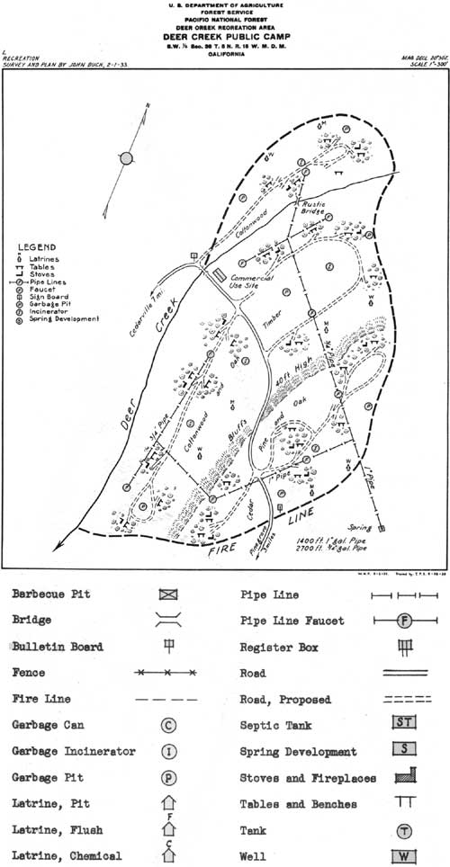
A definite plan must be prepared and the location of improvements must be staked on the ground, before development work is started on any camp ground. A preliminary map should be made on tracing paper. A final map on tracing cloth shall be made when construction is completed. This will serve as a permanent record. The maps should show the location of all improvements, designated by the proper symbols. Cost figures of improvement work must be kept wherever possible.
On all important camp projects, the Regional Office will, upon request, assist in the preparation of plans, and whenever special buildings or other improvements not contained in this Manual are found necessary in the development of a camp, the Regional Office will be glad to assist in drawing plans.
In making the plan for development of a camp, be sure to consider the suggestions in Dr. Meinecke's camp ground bulletins. The plan must be approved by the Forest Supervisor and the Regional Forester before work may be undertaken. The adjoining plate gives an example of how camp ground maps and plans should be prepared.
Final maps should be made Atlas size (18" x 21") on tracing cloth, following the general lines of Special Use maps. Whenever possible, a scale should be used which will permit the map to be made on a single sheet. A scale of one inch to 100 feet, 200 feet or 300 feet, will ordinarily be satisfactory.
The following symbols will be used on all camp ground maps and plans. Show everything possible in graphic form.
|
| (click on image for a PDF version) |
| <<< Previous | <<< Contents>>> | Next >>> |
|
region/5/public-camp-manual/sec3.htm Last Updated: 11-Jan-2010 |