|
Heceta House: A History and Architectural Survey |
|
SECTION ONE: HISTORY
I: BACKGROUND AND CONSTRUCTION
Heceta Head was named to commemorate one Don Bruno de Heceta, a Portugese credited with exploring much of the Northwest coast.
Historians generally agree that Heceta, a captain sailing for the Royal Navy of Spain, left for his exploration of the Pacific Northwest coast March 16, 1775. The captain launched his ship, Santiago, from San Blas, Mexico, carrying a year's provisions and 45 men.
He was joined in the expedition by Juan Francisco de las Bodega Y Quadra, who sailed the Sonora.
Heceta had orders to put in at the San Diego and Monterey missions, and then proceed north as far as 65°. The voyage was to be made in secrecy, and the captain was further commanded to ". . .land often, take possession, erect a cross and plant a bottle containing a record of the act of possession."1
1Gordon Speck, Northwest Explorations (Portland: Binfords & Mort, 1970), p. 81.
On July 30, 1775, Heceta and Quadra separated, probably as a consequence of stormy weather. A short time later, Heceta turned homeward, short of his goal of 65°. His early return was prompted by concern for his sailors, many of whom were suffering from scurvy.
Heceta did discover the mouth of the Columbia during the expedition, but he was unable to sail over the rough waters of the bar for further exploration of the river.
For his part, Quadra managed to take the Sonora as far north as Sitka, Alaska.
Heceta sailed into Monterey, California August 29, 1775. Thirty-five of his men were taken from the ship, too ill to continue the trip home.
With the close of the expedition, Bruno Heceta's career seems to have ended as well, for Spain cancelled all further voyages of discovery in 1780.
In addition to the near-discovery of the Columbia, the explorer sighted the headland that now bears his name, where he commented on the shallow water some distance off shore.
Soundings made by the U.S. Coast Survey in 1862 confirmed the captain's conclusions about the shallow waters. George Davidson of the Coast Survey suggested the names Heceta Head and Heceta Bank, which were adopted by the government.
Spain was not the only country to encourage explorers to lay claim to Pacific Northwest territory. Russia, Britian and the United States vied for the land as well. Competition for shore bases was particularly fierce between England and Spain, but eventually led to a series of agreements which effectively knocked Spain from the contest. Russia was eliminated in 1825, when pressure from Britian forced the czar to sign treaties ceding claims to the Oregon-Washington territory.
Britian was prepared to allow the United States to own the territory south of the Columbia, but the British wanted sole control of the river.2 However, the question of ownership was settled by the signing of a treaty of joint occupancy in 1818.
2Ray Allen Billington, Westward Expansion, A History Of The American Frontier (New York: The MacMillan Company, 1960), p. 509.
The following years were marked by the westward movement of many Americans into the Oregon territory. Some wanted a share of the profitable sea otter trade with China; others set out to establish churches in the wilderness; and a few courageous farmers were lured by tales of the Willamette Valley. The emigration culminated in the "great migration" of 1843, in which 1,000 persons traveled from Independence, Missouri to the Willamette Valley.
The British were active in settlement of the territory as well, largely due to the efforts of Hudson's Bay Company, which established Fort Vancouver on the Columbia. However, the United States won control of Oregon, including the contested waterway. American ownership was based on exploration and extensive occupation. On August 13, 1848, the bill creating the Oregon Territory passed Congress.
Coastal ports rapidly were established in Oregon, but trade was hampered by the fact that there were no aids to navigation on the west coast. In 1849, Congress sent a survey team to locate sites for construction of lighthouses. As a result of the survey, a total of sixteen lighthouses were authorized for the Pacific coast. These were built between 1852 and 1858, but with the exception of one light station on the Umpqua River, they were constructed in California and Washington. However, Congress made further appropriations for lighthouses in Oregon in following years. Additional lighthouses were constructed at Cape Blanco; the Coquille River; Coos Bay; Newport; Tillamook Bay; Tillamook Rock; and Astoria.
The government largely ignored the Siuslaw River during this period. In fact, a map accompanying the annual report of the superintendent of the Coast Survey, dated 1851, shows no river between the Umpqua and the Alsea, where the Siuslaw should have been.3
3Alferd L. Lomax, "Siuslaw and Willamette Valleys, 1850-91," from Oregon Historical Quarterly, Volume 36 (Salem: Statesman Publishing, 1935), p. 223.
However, in 1877 a 300-ton vessel named the Alexander Duncan stopped at Florence, and the settlement was commercially recognized from that date. In the following years, pressure for improvement of navigational facilities on the river increased considerably.
Approximately 1888, Senator Mitchell and Congressman Binger Hermann introduced a bill to provide $80,000 for construction of a light station at Heceta Head. The bill was approved by the Lighthouse Board4 and passed the Senate February 25, 1889.
4See appendix for information concerning Lighthouse Board.
The appropriation was made not to encourage trade along the Siuslaw, but to provide illumination for a notorius dark spot on the coast.
A recommendation made by S. C. Rowas, Vice-Admiral of the Navy, confirms this:
It does not appear that a harbor light is needed by the sparse commerce of this river. But it is quite evident that a coast light is required to divide the dark space between the two lights above mentioned [Cape Arago and Cape Foulweather].5
5Correspondence in Record Group No. 26 of the National Archives.
After the appropriation was approved, work on the station proceeded rapidly. In 1890, a survey of the site was made; a line for a roadway leading to the nearest county road was staked out; and negotiations for purchase of the land were begun.
Although Heceta Head was not owned outright by a private party, it was included in a homestead claim filed by Welcome E. Warren and his wife, Dolly. The Warrens, originally from Whatcom County, Washington, had filed a claim for 164 acres in 1888, which included both Heceta Head and Cape Creek.
Because the couple had not received title to the land, Congress passed a special act allowing them to sell a portion of the homestead to the U.S. Government for lighthouse purposes.
Accordingly, the government reserved approximately 19 acres of Warren's claim in a presidential order signed by Benjamin Harrison on July 18, 1891.
The couple received $750 for the land, plus an additional $75 for the sale of water rights to a spring located above the proposed station.
In addition, the Department of Interior set aside a tract of 239.2 acres for lighthouse purposes. This public domain land was reserved by executive order dated May 19, 1891. The acreage was located south of Cape Creek and included the partially timbered, mountainous area between the creek and Sea Lion Caves. It did not adjoin the lighthouse site, but was doubtless set aside to avoid undesirable encroachments near the station.6
6Because the land was never used by the Lighthouse Service, in 1941 the Siuslaw National Forest supervisor requested that it be transferred to the forest. The transfer was approved by the U. S. Coast Guard, which had taken over the Lighthouse Service, and by the Department of Interior. In 1943, the executive order of 1891 was officially revoked, and the land became part of the Siuslaw National Forest.
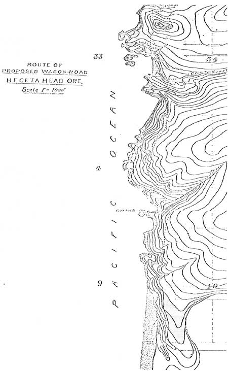
The Warrens also granted the government the right to construct a road through their property. The proposed route of the road is illustrated on the preceding page.
|
| Route of Proposed Wagon-Road, Heceta Head, Ore. |
William A. Cox, owner of the ranch at the south end of the road, signed an "indenture" granting the government right-of-way through his property. Under terms of the indenture, the government agreed to ". . .place substantial gates in all the present fences where the said right-of-way shall pass through the present fences."7
7Document contained in National Archives, Record Group No. 26.
According to the Annual Report of the Lighthouse Board, the 7-mile wagon road was completed April 12, 1892. Construction costs of the road were not mentioned.
The Heceta Head station was designed in the grand style. Plans included the tower, two oil houses, barn, single dwelling for the head keeper and duplex for two assistants. The architectural plans used for the Umpqua station were duplicated for Heceta Head, which no doubt saved valuable time.
In 1892, contracts for construction of the buildings were awarded and some of the work was begun. The lowest bid for metal work on the tower was $5,000; the bid for construction of the tower and oil houses was $13,700; and the bid for keepers' dwellings and barn was $26,470.128
8Ibid.
The reports of the Lighthouse Board do not include the names of the firms that received the contracts. However, records at the Oregon Historical Society show that the contract for barn and dwellings went to H. M. Montgomery & Co., a Portland based firm.
Montgomery worked on at least one other light station; his file at the historical society includes a bill for materials used for the Umpqua River Lighthouse barn.
At Heceta Head, Montgomery alone employed 56 men, including carpenters, laborers, one bookkeeper, five teamsters and a foreman by the name of Charles H. Page. Payroll records Page forwarded to Montgomery indicate the going rate for laborers was $2 a day, while the highest paid carpenter took in $4 a day. (Total payroll for the period from May 1 to June 1, 1892 was $880.94.) Workers averaged 10 hours a day.
The company paid the lodging of some of the employees, among them, the bookkeeper and Page. Again, the Warren family benefited from construction of the station, this time by taking in the workers. For the month of May alone, Montgomery ran up a bill of $426.98 with the Warren "boarding house."
Those not lucky enough to board with the Warrens bedded down in the tent pictured below.
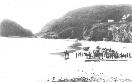
|
| Photograph dated summer, 1892. Duplex is near completion, though work on the single dwelling and tower had not begun. The tent pictured to the left of the duplex was canvas with wood frame. |
Despite construction of the wagon road, transportation of materials was difficult at best and impossible at worst.
Lumber was shipped by mills in Florence and Mapleton to the mouth of the Siuslaw, and the rafts then were towed to Cape Cove. From there, they were hauled up the slope to the construction site. As an alternate method, lumber was bound in bundles, carried to the site by tug, thrown overboard near Cape Creek beach, and finally rescued when it floated to shore.
Not all lumber arrived safely, and other items for construction were lost to the seas as well. In one instance, a shipment of water pipe was placed on one of the rafts. It failed to arrive, though bills of lading showed it had been shipped. Workers were forced to conclude the pipe had fallen through shifting lumber.
Bricks and cement were shipped from San Francisco to Florence, reloaded on the tug Lillian, owned by Meyer and Kyle, and transported to the mouth of the Siuslaw. They then were hauled to the Cox ranch by team and wagon owned by George Prescott. If weather was fair and the wagon road to the construction site was dry, the materials were easily hauled the remaining distance. But more likely than not, the road was made impassable by mud, and the bricks sat at the Cox ranch until conditions improved.
Delivery of bricks and cement was among the easier runs made by Prescott. As steamers were not licensed to carry explosives, the blasting materials had to be hauled over mountain roads from Florence. George Prescott was enlisted for the job.
According to one of Prescott's descendants, on one occassion the teamster was hauling dynamite when a young man by the name of Jack Bunch begged a ride to the Head.
"The road was real rough. When Jack found out George was hauling dynamite, he decided he'd rather walk."9
9Mrs. P. O. Carlson, correspondence dated October, 1979.
While the threat of exploding dynamite bothered Jack Bunch, it did not worry the sea lions lounging at the caves near Heceta Head. "Blasting at the lighthouse does not seem to scare the sea lions away," the Florence newspaper, The West, reported.10
10The West, as quoted in The Siuslaw Pioneer (Florence, Oregon: 1955), p. 6.
Like many of the workers at Heceta Head, George Prescott was a local man. In fact, many residents of Waldport, Yachats and Florence have a grandfather, or great-grandfather who was involved with construction of the station.
Les Akerly, a native of Florence, claims his homesteader-father worked on the lighthouse, helped out at Meyer and Kyle's store, and took any carpentry jobs he was offered.
"Most homesteaders worked on farms in the winter, summer they went out to make a few extra dollars," Akerly explained.11
11Tape of private interview with Les Akerly conducted by Kim Stafford at Florence, Oregon, February, 1976.
This was the experience of German immigrant Claus Ludeman, who homesteaded near Yachats. According to his daughter, the family sorely needed any extra money that could be earned.
You might wonder what people did for a living in those hazardous times and so far from supplies. For three years Papa helped build the Heceta Light House, tediously and skillfully applying his old world techniques doing the interior work in the two keepers' houses, which boasted very impressive stairways.12
12Anna Ludeman McMillin, as quoted by Marjorie H. Hays in The Land That Kept Its Promise (Newport, Oregon: Lincoln County Historical Society, 1976), p. 8.
It is likely that foremen and highly skilled workers had to be "imported." Fortunately for these outsiders, a post office was established at Heceta Head February 19, 1891. Original location of the post office is not known. It is possible the Warren house was used until one of the keepers' dwellings was erected at the station.
By the close of 1892, the barn was completed, the foundations and framing of the keepers' houses were finished and metal work for the tower was delivered.
Windows, finished lumber and other accessories then began arriving by the lighthouse tender Columbine, which sailed out of Tongue Point, Oregon. The rock that forms the base of the tower was brought from the Clackamas River near Oregon City, loaded aboard the Columbine, transported to the mouth of the Siuslaw and finally hauled by Prescott to the head.
The lens for the lighthouse was transported by the government steamer Manzanita and unloaded near the tower by means of surf boats. The unloading was no doubt a harrowing experience, for the British-made piece was extremely valuable. Cost of the lens is not listed in any government document, though the son of one head keeper places the price at around $10,000.13
13Robert E. DeRoy, correspondence dated November 12, 1979.
The hand-ground, "first-order"14 lens is composed of eight panels made up of 640 prisms, each two inches thick. It is unusual that the lens was manufactured in England, as Fresnel lenses made in France had been used previously. Again, government documents do not explain this question.
14The order of a light is determined by the focal length of the lens, that is, the distance from the center of the light to the inner surface of the lens. A first-order lens has a 36-inch focal length.
The lens revolved once every eight minutes. The revolutions were controlled by a system of weights, called clockworks, which were wound by hand.
Heceta Head was to be recognized by a white light flashing once every minute. Such a pattern was important, as the following passage explains:
Marine disasters have occurred from the mistaking of one lighthouse for another and it is evidently important that lights be so distinguished that the navigator may recognize with certainty the light he sees. To this end lights are known by their number, color, intensity or time of visibility.15
15George R. Putnam, Lighthouses and Lightships of the United States (Cambridge: The Riverside Press, 1933), p. 194.
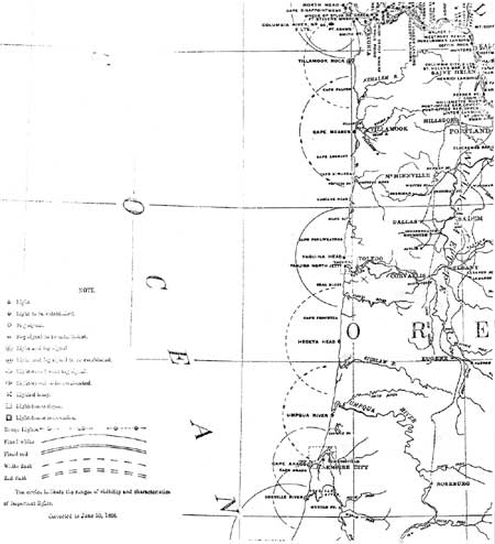
|
| Section of a map illustrating the light "patterns" of Oregon lighthouses. (click on image for a PDF version) |
According to Annual Reports from the Lighthouse Board for 1893, the tower was completed August 31, 1893. The lens had arrived in October of 1892 and was set up in November. All other buildings were finished as well.
However, the lighthouse could not begin operating until the lamp for the tower arrived. There was a delay in receiving this shipment, which had to come from the general lighthouse depot at Staten Island, New York.
The five-wick lamp finally arrived in February of 1894. Once placed inside the lens, it generated 80,000 candle power, visible 20 miles. The original lamp burned kerosene, or coal oil, as the keepers called it. Supplier of the oil was, in the words of one writer, "That gigantic monopoly, the Standard Oil Company..."16
16The West (Florence, Oregon, December 6, 1895), p. 1.
Once the lamp was in place, the station was ready for operation. This event was awaited by mariners and the residents of Florence alike, as this quotation from The West indicates:
Mr. McCloud, who had charge of setting the lamps at Heceta Head, finished work and left for Portland. Now the beacon lamp is ready to have the match applied, and only waits the coming of the keepers, and an order from the board.17
17The West, as quoted in The Siuslaw Pioneer (Florence, Oregon; 1955), p. 6.
In March of 1894, Mr. R. D. Lang, who had acted as caretaker of the Heceta Head grounds and buildings, turned over the keys to the first head keeper, and on March 30, the long-awaited match was applied to the light.
| <<< Previous | <<< Contents>>> | Next >>> |
region/6/siuslaw/heceta_house/sec1-1.htm
Last Updated: 04-Aug-2008