|
The Geologic History of the Diamond Lake Area
|
|
GEOLOGIC HISTORY OF THE DIAMOND LAKE AREA
GENERAL DEVELOPMENT OF THE HIGH CASCADES
The oldest rocks exposed in the Diamond Lake area represent the Eocene, Oligocene, and Miocene Epochs. Therefore, they range from about 60 million to 12 million years in age. These rocks are exposed several miles to the west and northwest of Diamond Lake. More specifically, they make up Trap Mountain, Beartrap Meadows, Black Rock, Rhododendron Ridge, and the intervening canyons and hills to the west of Diamond Lake; and Birds Point, Potter Mountain, Thorn Mountain, Perry Butte, and the intervening country to the northwest of Diamond Lake. These lavas extend many miles to the west of the Diamond Lake area and make up the Western Cascades.
A glance at a topographic map of the Diamond Lake area reveals a decided change in the configuration of the land surface across the boundary between the Western Cascades and the High Cascades. The High Cascades consist of altered conical forms of obvious volcanic origin in various stages of erosion, whereas the Western Cascades consist of an area of irregular ridges and canyons which have been aptly described as a "sea" of peaks and ridges. These ridges and canyons bear no relationship to the original volcanic forms; that is, what is now a topographically high ridge initially might have been a low area between surrounding volcanic peaks. Conversely, what originally might have been a high volcanic peak now might be a deeply eroded canyon. The reason for the marked difference between High Cascade and Western Cascade topography is the greater length of time which has ensued since the formation of the rocks making up the Western Cascades. Erosion has proceeded to wear down these rocks from the instant they were poured out on the surface. During the past 60 million to 12 million years the original volcanic forms have been destroyed, and a more-or-less random network of streams now drains the area. The resulting topographic pattern is termed "mature".
The general nature and composition of the igneous rocks making up the Western Cascades have been described in an earlier section of this report. Suffice it to say here that these rocks, compared with the lavas of the High Cascades, present a more weathered appearance. They are more limonite-stained, more thoroughly altered mineralogically, and contain intrusions of coarser-grained igneous rocks that are absent in the lavas of the High Cascades.
As explained earlier, the Western Cascade lavas underlie the High Cascade lavas in the Diamond Lake area. They simply are overlapped and obscured by the younger High Cascade lavas which, having risen through fractures in the Western Cascade lavas, proceeded to bury the older rocks with fresh flows of molten lava.
The crustal disturbance at the close of the Miocene Epoch, some 12 million years ago, folded and fractured the Western Cascade lava platform. A series of north-south fractures developed along the eastern margin of the Cascade plateau and lava began to well up at various points along these fractures and build new volcanoes. The spacing of the new volcanoes indicates the fracturing of the old lavas did not occur as a single fissure. Mt. Bailey and Mt. Thielsen, for example, which are both High Cascade volcanoes, lie on an east-west line. Viewed in a broader perspective, these two peaks form a portion of a mountain chain that is only a few miles wide, but several hundred miles long. Mt. Bailey and Mt. Thielsen probably grew along separate, but parallel, north-south fractures. Three miles to the north of Mt. Thielsen lie Howlock Mtn. and Tipsoo Peak. Two miles north of Mt. Bailey lie Rodley Butte and another, smaller cinder cone. The north-south lineation of the volcanoes thus is revealed on a small scale with in the larger framework of the Cascade Range.
The fractures in the Diamond Lake area reached deep enough into the earth's crust to tap rocks hot enough to melt if they were not under such great pressure. The fractures reduced this pressure and the rock fused, then began to work its way upward along the fractures. The first eruptions of this lava began at Pig Iron Mountain and Watson Butte, the oldest High Cascade volcanoes in the Diamond Lake area.
The relative ages of the High Cascade volcanoes are established on the basis of the degree to which they have been eroded and glaciated, and where possible to observe, the relationship of their lava flows. The mountain mass consisting of Pig Iron Mountain, Watson Butte and Elephant Mountain is entirely surrounded by the younger intracanyon basalt which obscures the contacts between lavas of those volcanoes and any others. However, the degree of erosion of those mountains suggests they are the oldest of the High Cascade volcanoes. It would be difficult to determine, from topographic form alone, whether or not these masses were volcanoes. However, examination of the rocks reveals a vent existed near the summit of Pig Iron Mountain; hence the mass is included in the High Cascades rather than the older Western Cascades. The High Cascades, which are less than 12 million years old, have retained a more-or-less conical shape despite subsequent erosion.
|
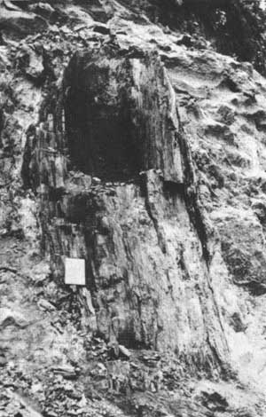
| Petrified — carbonized tree trunk near Loafer Creek. |
An interesting feature is exposed on Forest Service Road No. 264.1 about 2-1/2 miles northeast of Toketee Reservoir. This site is on the northern edge of the Pig Iron Mountain—Watson Butte mass, near the junction of Loafer Creek and the North Umpqua River. At this point the road cut exposes a tree trunk whose outer shell is petrified and whose center is carbonized. The trunk measures 3 to 4 feet in diameter and is about 8 feet high. The root system extends another 6 feet below the base of the trunk and appears to be naturally emplaced in a weathered "tuff". Tuff is a rock composed of fragments of volcanic rock. The trunk itself is surrounded by a pale green lava flow containing white feldspar crystals. The rock layer above the truncated tree is an other tuff bed. Scattered through the lava layer surrounding the trunk are carbonized limbs up to 1 foot in diameter and smaller fragments. The majority of these are scattered down-flow from the trunk. The sequence of events leading to the preservation of such a feature must have been as follows: The tree initially was growing on a thin soil zone covering a layer of tuff. Its roots pierced cracks in the rock to a depth of 6 feet or more below the surface. The tree then was engulfed by a lava flow which caused it to break about 8 feet above the ground. Limbs and twigs fell into the flow and were swept down hill by it. The flow was hot enough to sear and carbonize the entire trunk and those limbs that were engulfed by the flow. The tuff bed below the flow was baked and the roots piercing the tuff also were carbonized. The mass cooled and was later covered by another tuff layer. The tree and branches at this time probably were carbonized completely.
Later, silica-bearing solutions worked their way up the contact between the carbonized wood and the lava and began replacing the carbonized wood with silica. This process continued until only the central core of the tree remained carbonized. The result is a petrified silica sheath surrounding the carbonized core. The wood texture is well preserved in both the carbonized and silicified portions of the tree. The lava rock immediately adjacent to the silicified trunk contains minute flecks of pyrite, an iron sulfide mineral. Pyrite commonly forms in the presence of carbon, which reduces the ubiquitous iron to the sulfide form. This is an indication that the outer portion of the tree (now silicified) originally was carbonized, as the center is still.
The limbs and branches which are engulfed entirely by lava are carbonized, not silicified. These fragments are not silicified because they are not in contact with the more porous tuff beds, as is the main trunk. Mineralizing solutions were provided access to the main trunk through the porous tuff beds into which the root system of the tree extended.
It is believed the tuffs and lava encasing the tree are associated with lavas and tuffs of the Pig Iron Mountain and Watson Butte volcanoes, as they are totally unlike the dense, grey, olivine basalts which make up the intracanyon flows. This means the tree is between 12 million and 1 million years old—probably closer to the former.
GROWTH OF MT. THIELSEN AND MT. BAILEY
It probably was shortly after the disturbances at the close of the Miocene, and just after the initiation of volcanic activity at Pig Iron Mountain, that Mt. Bailey, Mt. Thielsen, Howlock Mountain, and the other High Cascade peaks in the Diamond Lake area began to erupt. The lavas and eruptive history of Mt. Bailey, Mt. Thielsen, and Howlock Mountain are very similar, and are representative of the other High Cascade peaks in the area. These volcanoes will be discussed in some detail, and occasional references will be made to other peaks in the Diamond Lake area.
The bulk of Mt. Thielsen, Mt. Bailey and Howlock Mountain consists of pyroxene basalt. There is a small amount of olivine in the basalt but the amount of the mineral pyroxene exceeds that of olivine in virtually all samples. Pyroxene is a mineral group containing several members. On the lower slopes of Mt. Thielsen the lavas contain mostly hypersthene pyroxene; on the upper slopes, augite is the predominant pyroxene. Changes in color and texture of the lavas on the lower and upper slopes are also noticeable. The lavas of the upper slopes are more vesicular—that is, they contain more voids, or holes—which indicates they originally contained a greater amount of gas than did the lavas of the lower slopes. Also, the lavas of the upper slopes are darker in color due to the higher content of magnetite in the glassy matrix of the lavas.
All the lavas described above were extruded over a period of 10 million years or so. As stated, the initial eruptions probably began shortly after the close of the Miocene, some 12 million years ago, and continued to erupt until about 1 million years ago. These lavas were very fluid and flowed rapidly away from the point of their extrusion, building a broad, shield-type volcano. The flows were extruded from the central vent, and probably also from fissures in the sides of the volcano. The flows making up Mt. Thielsen extended for miles away from the summit—the east-west diameter of the volcano is about 10 miles.
Within two miles due north of the summit the flows interfinger with those of Howlock Mountain. The longest flows from Mt. Thielsen and Howlock Mountain are in a northwesterly direction from their summits; flows from Mt. Thielsen extend over 7 miles in that direction.
During the approximately 10 million years Mt. Thielsen was active, hundreds of flows issued from its summit and flanks. Most of the flows exposed on the upper slopes are between 5 and 10 feet thick, and slope outward from the summit at about 5°. When its full growth was attained, the lava cone of Mt. Thielsen stood between 6,000 and 7,000 feet above the old Cascade platform which, itself, was 3,000 to 4,000 feet above sea level. Hence, Mt. Thielsen rose ultimately to a height of 10,000 or more feet above sea level.
Near the end of the eruptive history of Mt. Thielsen the nature of material issuing from its summit changed. The volcano became explosive and began throwing out fragments of solid rock, cinders, and pasty clots of magma. The crater at the summit measured about 1-1/2 miles in diameter and was several hundred feet deep. This crater was filled with cindery, fragmental material which eventually overlapped the limits of the crater. The cinder cone consists of yellow, grey, and brown tuffs containing numerous angular blocks of old lava which were torn loose from the throat of the volcano at depth and blown out the vent with the fresh cinders and lava. The cinder cone itself contains many tabular sheets of igneous rock which resulted from the injection and cooling of magma in the cinder beds. As explosive forces ripped through the cinder cone, numerous fractures developed in these beds. Molten lava from depth was forced into these fractures and congealed there, forming dikes. Most of these dikes are about 6 feet wide. Some of the lava squeezed through the fractures and flowed down the flanks of the cinder cone to form thin basalt flows.
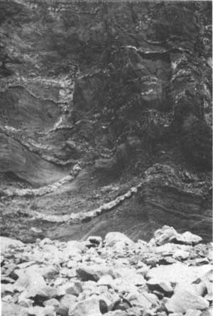
|
| Dikes in exposed cross-section of cinder beds on Mt. Thielsen. |
The explosions which built the cinder cone alternated with periods of quiet inactivity during which gas pressure mounted in the magma chamber. The magma in the conduit above the magma chamber cooled and solidified during these periods of inactivity, only to be shattered and blown out when increasing gas pressure from below overcame the solidity of the plug of frozen lava in the throat of the volcano.
During the last stages of volcanic activity the magma in the conduit of Mt. Thielsen solidified partially or completely to form a plug. The pressure from below was great enough to force this plug upward as a solid or semi-solid mass, but did not fracture it or blow it from the conduit. As the plug rose through the cinder cone it dragged the adjacent cinder beds upward so they sloped steeply away from the plug. In some places the cinder beds are so deformed that they are vertical or slightly overturned next to the plug.
Another plug developed simultaneously and is exposed about one-half mile to the east of the one just described. The cinder beds adjacent to it dip sharply, like those surrounding the main plug. The cinder cone atop Mt. Thielsen, therefore, was built around two closely spaced vents, both within the limits of the crater.
The plugs themselves consist of more-or-less vertical cylinders of dark grey to light grey lava. The outer margins of the plug are fine grained and dark colored, due to their more rapid cooling. The texture and color grade inward to a coarser grained and lighter grey lava in the central portion of the plug. This portion cooled more slowly; therefore, the crystals had time to grow larger and the gas contained in solution exsolved, producing a vesicular texture in the interior portion of the plug.
Also near the close of Mt. Thielsen's eruptive history, and perhaps even later than the building of the cinder cone at its summit, two parasitic cinder cones developed near the base of the volcano. These are located to the south and southwest of the summit, and consist of fragmental lava, cinders, and scoria. The surfaces of these cones are now heavily timbered, making exposures of the rock scarce.
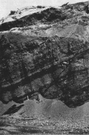
|
| Cinder beds exposed in rock pit on Kelsay Point. |
Summit Rock, an intrusive plug very similar to the plugs at the summit of Mt. Thielsen, lies at the base of Mt. Thielsen about 3-1/2 miles south of its crest. The dense lava making up this plug is suitable for use as road metal, and currently is quarried for that purpose. This rock is of interest to the mineral collector because it contains labradorite and pigeonite in the ground mass; also, small crystals of hematite, hypersthene, acmite, albite, apatite, cristobalite, and tridymite appear as incrustations lining small fractures and vesicles in the rock. Cristobalite and tridymite also are found in the plugs at the summit of Mt. Thielsen. The summit crater measures about a mile in diameter and contains an intrusive plug. The rock making up the plug is essentially identical to that making up the plugs on Mt. Thielsen. The diameter of the Howlock volcano is about the same as that of the Mt. Thielsen volcano, but the cone is about 1,000 feet lower. Like those of the Mt. Thielsen volcano, the longest Howlock lava flows merge with those from Mt. Thielsen along Thielsen Creek.
Several cinder cones are scattered over the slopes of Howlock Mountain. Tipsoo Peak, Red Cinder Butte, and Cinnamon Butte are the largest of these. Tipsoo Peak and Cinnamon Butte are breached cones. A portion of their flanks was blown out, giving an arcuate or crescentric form to the cones.
Cinnamon Butte, Kelsay Point, and other cinder cones in the Diamond Lake area are littered with volcanic bombs and fragments of bombs. These range in size from a few inches to a few feet across, and display fine grained rinds and bubbly, vesicular interiors.
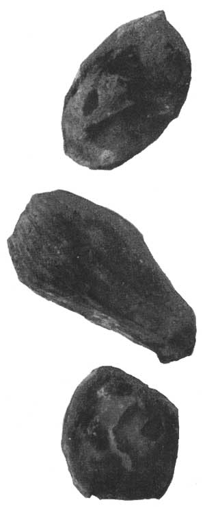
|
| Volcanic bombs taken from Cinnamon Butte. |
The cinder beds at Kelsay Point have been well exposed by a quarrying operation. The beds at the summit of the cone dip northerly, indicating the vent lay somewhere to the south of the present summit. The cinder beds display well developed layering of coarser and finer fragments, and contain volcanic bombs and blocks up to several feet across. (The large, reddish bomb displayed on the porch of the Information Center at Diamond Lake was taken from the Kelsay Point cinder cone.) The variance in the size of the cinders and fragments in given layers reflects the variation in intensity of the eruptions that blasted the material from the vent.
The Mt. Bailey volcano was built contemporaneously with Mt. Thielsen and Howlock Mountain. The lava flows from Mt. Bailey and Mt. Thielsen interfinger beneath Diamond Lake. The flows from Mt. Bailey extend some 6 or 7 miles northward from its summit, and there they are overlain by the younger, glowing-avalanche deposits which obscure the contact between the Mt. Bailey lavas and the intracanyon basalt flows. To the west and northwest of Mt. Bailey the lavas overlap the older Western Cascade lavas. About 2 miles to the south of the summit of Mt. Bailey, the Bailey lava flows merge with those of Twin Knobs and Sherwood Butte. These hills form a portion of a deeply dissected, basaltic lava cone. The flows making up Mt. Bailey are very similar to those making up Mt. Thielsen in that the later lavas are darker in color and more vesicular than the earlier flows. Mt. Bailey also is capped by a cinder cone, though it is much smaller than the one capping Mt. Thielsen. The cinder cone atop Mt. Bailey neither contains dikes, which are numerous in the Mt. Thielsen cone, nor does it contain a central plug, of which Mt. Thielsen has two. At the south end of the main ridge crest leading to Mt. Bailey's summit is a small, subsidiary crater. The crater is well preserved, and evidently was formed near the cessation of volcanic activity. From the lip of the crater to its bottom is a vertical distance of 50 to 100 feet. The crater apparently contains some snow the year round.
When the Bailey volcano had attained its full height, it stood perhaps 1,000 or 2,000 feet lower than Mt. Thielsen. Like Mt. Thielsen, Mt. Bailey grew over a period of several million years and became inactive about one million years ago.
|
| Arête divides two glacial cirques high on slopes of Mt. Thielsen. |
About 3 miles down the north slope of Mt. Bailey are two parasitic cinder cones. The larger of these, Rodley Butte, has the typical crescentric shape of a breached cinder cone. Two and one-half miles southeast of the summit, near the base of Mt. Bailey, lies Hemlock Butte—a parasitic lava cone. The material extruded at this point was fluid, rather than fragmental, and resulted in a small volcano perched on the lower slopes of Mt. Bailey.
Kelsay Mountain is another High Cascade volcano that grew in the Diamond Lake area during the Pliocene Period. Numerous cinder cones also grew during this period, and these include Red Cinder Butte, Thirsty Point, Tenas Peak, and Windigo Butte.
GLACIATION OF THE ICE AGE
Approximately one million years ago, at the close of the Pliocene, the Great Ice Age descended on the area. The alternate advances and retreats of ice and snow lasted until a scant 10,000 years ago.
As the Ice Age crept upon the area, the winter snows high on the slopes of Mt. Bailey and Mt. Thielsen remained a little longer each spring. The climate grew gradually cooler, and soon the snows did not melt during the summer, but remained to be buried by the next winter's snows. In this manner, ice and snow began to accumulate on the higher peaks in the Diamond Lake area. The weight of new snow compacted the old, producing dense granular, glacier ice. The dense ice flowed imperceptibly down the flanks of the mountains—the glaciers were advancing over the landscape.
The volcanic peaks in the Diamond Lake area became inactive about the time glaciers began to form on them. The peaks were thus unable to resist the attack of glacial erosion. Younger High Cascade peaks, such as Mt. Mazama some 15 miles to the south of Mt. Bailey and Mt. Thielsen, continued to expel lavas and grow in stature, despite the erosive effects of the glaciers. Striations left on the rocks high on Mt. Mazama indicate glaciers once crept down the sides of the mountain. The striated lavas are overlapped by younger flows, indicating the volcano continued to spew out lava throughout and after the period of glaciation. Mt. Mazama retained its conical form despite extensive glaciation.
Meanwhile, the glaciers began to gouge at the sides of the extinct volcanoes in the Diamond Lake area. Glaciers crept radially away from the higher peaks such as Mt. Bailey, Mt. Thielsen, and Howlock Mountain. The flanks of the defenseless mountains were hollowed out in great scoops, forming cirques. The ice creeping down the east slope of Mt. Bailey merged with the glaciers flowing down the west slope of Mt. Thielsen. These were joined from the south by a large glacier whose head was high on Mt. Mazama. The entire area now occupied by Diamond Lake, the lower slopes of Mt. Bailey and Mt. Thielsen, and the area to the south of Diamond Lake were covered by a vast ice field.
|
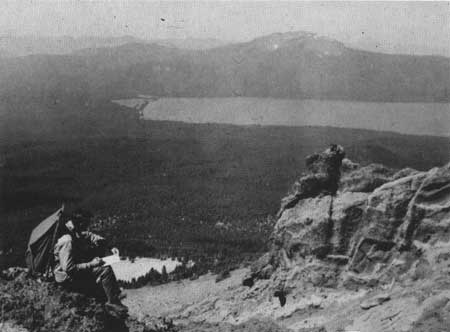
| Diamond Lake and Mt. Bailey as seen from Mt. Thielsen. |
Several times during the Pleistocene the ice advanced and, by melting, retreated. Each time the ice melted, the ground-up rock powder it contained was washed downstream and deposited in layers or beds. These beds of glacial clay are impervious to water. As water from rain and melting snow percolates down through the younger soil and rocks above, and encounters the clay bed, it is unable to penetrate the clay layer and so moves downslope along the top of it. If the clay layer intersects the surface, the water seeps out at that point to form a spring. The numerous springs east of Lemolo Lake, including Crystal Springs and those feeding Spring River, originate in this manner.
The last advance of the glaciers was the most extensive. As the ice covering the valley between Mt. Bailey and Mt. Thielsen melted, it left behind a shallow lake. Diamond Lake measures about 3 miles by 1-3/4 miles, but is only slightly more than 50 feet deep. Melting glaciers furnished the water. The toe of a lava flow from Mt. Thielsen provided a low dam across the north end of the lake. The shallowness of the lake is governed by the elevation of its outlet, Lake Creek, which drains Diamond Lake at its northwest corner.

|
| Lightning strikes tip of Mt. Thielsen during night storm. |
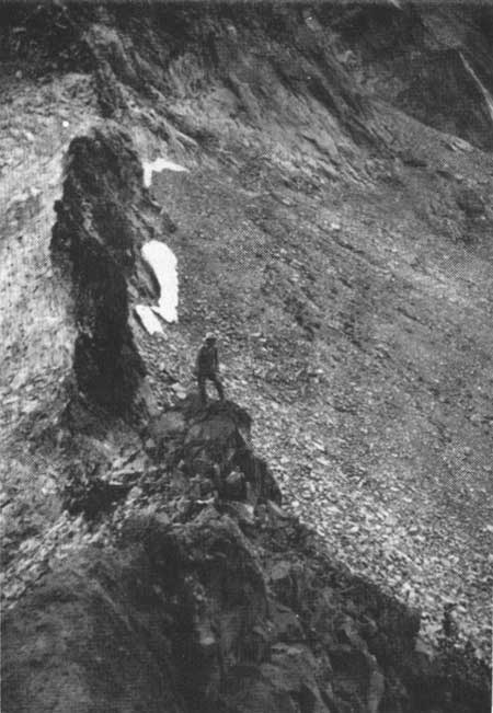
After the last attack of the glaciers had subsided, the high peaks in the Diamond Lake area had changed shape. Mt. Bailey was no longer a symmetrical cone, but contained large cirques which exposed the layers of lava and cinders that the volcano had extruded near its summit. This mountain, however, was not as severely carved as Mt. Thielsen, which was initially much higher than Mt. Bailey. Glaciers had sculpted the top of Mt. Thielsen from all sides, producing a series of cirques whose edges widened until they met, thus forming long, sharp ridges extending radially from the mountain tops. These ridges are called arêtes. The soft cinder beds were more easily glaciated than the dense plugs occupying the vents of the volcano. The cirques that developed about the western plug left it standing steeply above the ridges and cirques below as a sharp pinnacle, or matterhorn. This spire is between 100 and 200 feet high and has given rise to the nickname which is applied to Mt. Thielsen, "The Matterhorn of the Cascades".
Mt. Thielsen also is called "The Lightning Rod of the Cascades", and with good reason. This peak is frequently struck by lightning, resulting in the creation of a geological oddity—fulgurites.
The name fulgurite is derived from the Latin for thunderbolt. Fulgurites are blebs, coatings, or tubes of bubbly glass, formed by the instantaneous fusion of rocks or sand when struck by lightning. The intense heat fuses the rock to a bubbly glass devoid of even the smallest crystals which generally are present in glassy volcanic rocks.
The fulgurites on Mt. Thielsen are splotches, or bubbly coatings, of brownish-green glass which resemble drops of paint spattered on a greasy surface. Occasionally the fulgurite takes the form of a glass-lined hole in the rock, less than an inch in diameter and tapering several inches into the interior of the rock. Such carrot-shaped forms are called "lightning tubes". The great majority of the fulgurites on Mt. Thielsen are confined to the uppermost 5 or 10 feet of the summit. Obviously, the top of Mt. Thielsen is an imprudent spot to select for sitting out a thunderstorm!
Fulgurites have been reported atop other sharp Cascade peaks, notably Union Peak.
Other peaks in the Diamond Lake area are more-or-less glacially carved, depending primarily upon their elevation. The size and thickness of glaciers on the lower peaks was insufficient to produce extensive glaciation.
The last melting of the glaciers, which occurred about 10,000 years ago, littered the slopes of the mountains with rock material varying in size from large boulders to fine dust. This material had been frozen in the glacier, and simply was dumped on the ground when the ice melted. Forests have re-established themselves on the mountain slopes, and at present the heavy forests and glacial debris obscure most of the lava flows on the lower slopes of the volcanoes in the Diamond Lake area.
THE INTRACANYON BASALTS
Some time after the growth of Pig Iron Mountain and Watson Butte (which began about 12 million years ago), and the retreat of the last glaciers (which occurred at least 10,000 years ago), lava flows unlike any others in the area poured out of the earth's crust several miles to the north of Diamond Lake. These are the intracanyon basalts of the Clearwater and North Umpqua drainages.
The flows consist of dense, light grey, olivine basalt. The lava welled up from a fissure east of the Pig Iron Mountain — Watson Butte — Elephant Mountain mass. Elbow Butte possibly was the vent from which it issued. The molten lava was extremely fluid and flowed out in copious sheets that rushed away from the vent like thin mud. Some of the material rolled up the drainage of the North Umpqua River almost 3 miles to the base of Kelsay Point, but the bulk of the flows rushed down the valley of the North Umpqua and circled the north boundary of the Pig Iron Mountain — Watson Butte — Elephant Mountain Mass. A portion flowed down the Clearwater River drainage to the south of the mountain mass and rejoined the flows circling the mass to the north. From this point the lava continued down the drainage of the North Umpqua River for several miles.
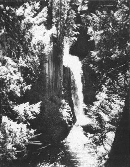
The edges of the intracanyon flows chilled to jagged, clinkery blocks as the bulk of the lava flowed on. This blocky lava may be seen along the North Umpqua Highway in the vicinity of Lava Creek and Clearwater Falls. At the latter place, the Clearwater River tumbles over the moss-covered, jagged blocks creating one of the most scenic spots in the Umpqua National Forest.
The valleys surrounding the Pig Iron Mountain — Watson Butte — Elephant Mountain Mass, previously eroded by streams, were now partially filled by these lava flows, giving them flat floors. These flows produced the broad level areas such as Thorn Prairie to the north of the mountain mass; and Mowich Park, Toolbox Meadows, and Fish Creek Desert to the south of it.
|
| Toketee Falls cascades over columnar jointing of intracanyon basalts. |
The sudden alteration of the configuration of the stream valleys disrupted the drainage pattern in the area. The streams draining the surrounding mountain mass now abruptly disgorged onto the broad valley floor instead of continuing down their old water courses to the bottom of a deep canyon. These streams hugged the contact between the old mountain mass and the fresh lava beds, and flowed westward along this contact. Since the flows filled the North Umpqua and Clearwater valleys, the subsequent stream erosion along Clearwater River and Mowich Creek to the south of the mass, and along Loafer Creek to the north of it, has carved new, narrow canyons as much as several hundred feet deep along these contacts. The waters of the North Umpqua River were diverted along the contact at the northern edge of the flows between the intracanyon basalt and the High Cascade and Western Cascade rocks.
The tributaries of the Clearwater River which drain the area south of Mowich Park and southeast of Fish Creek Desert flow directly across the flat top of the intracanyon basalts and plunge abruptly into the steep canyon of the Clearwater River. Because the erosive power of these streams is less than that of the larger river, they have cut into the rocks much less, and upon reaching the deeper canyon tumble sharply into it. Watson Falls, almost 300 feet high, is formed where Watson Creek drops from its shallow stream channel over the lip of the Clearwater River Canyon.
Fish Creek, which skirts the Fish Creek Desert on the south, flows along the boundary between the intracanyon flows and the older rocks to the south. It appears that the major streams existing at the time the intracanyon flows filled the canyons were diverted along the margins of these flows; and the smaller streams which developed subsequent to the lava flows wander over the surface of the intracanyon lavas.
|
| Columnar jointing on Pig Iron Mountain. |

|
| Columnar jointing near Soda Springs. |
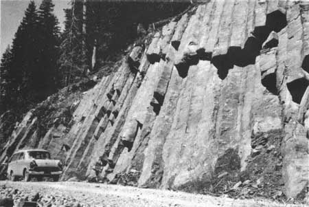
A very pronounced aspect of the intracanyon flows is the prominent development of columnar jointing. Most of the columns are vertical, and range up to 50 feet in height and 2 to 3 feet in diameter. The columnar jointing is particularly well exposed at Soda Springs, about 5 miles west of Toketee Ranger Station.
This jointing, in large part, is responsible for the development of waterfalls such as Toketee Falls, Slide Creek Falls, and Watson Falls. As the rock weathers the columns tend to collapse, leaving sheer vertical walls. The height of the waterfalls plunging over these walls is dependent upon the height of the columns; the height of the columns, in turn, is dependent upon the thickness of the flow in which they formed. The lofty spires standing erect between the canyon walls along the North Umpqua River between Eagle Rock and Toketee Reservoir were formed in the same manner.
THE ERUPTION OF MT. MAZAMA
From the close of the Pleistocene, some 10,000 years ago, to the present, the geologic history of the Diamond Lake area has been dominated by Mt. Mazama. Mt. Mazama is the name given to the vanished mountain peak whose collapse created the caldera now occupied by Crater Lake some 15 miles to the south of Diamond Lake. The major growth of Mt. Mazama was accomplished during the Pleistocene; and the volcano remained active until a few thousand years ago. After the ice receded, Mt. Mazama's smoking summit stood an estimated 12,000 to 14,000 feet above sea level.
A few thousand years ago Mt. Mazama began to erupt volcanic ash and pumice. At first the eruptions were weak and irregularly spaced, but they gradually increased in intensity and frequency. For a period of several weeks these eruptions continued. Pumice fragments ranging in size from fine dust to several inches in diameter were hurled from the vent. At the time of these eruptions the prevailing wind was toward the northeast. The pumice was light enough to be blown in that direction. The coarser fragments fell on the slopes of the volcano while the finer material was carried farther by the winds. In the Diamond Lake area the pumice fragments are mostly between 1 and 4 inches in diameter. Farther to the northeast, the material becomes progessively finer.
As the pumice fragments become smaller away from their source the thickness of the deposit diminishes. The thickness of the pumice blanket has been mapped by the use of isopach lines, which are lines representing equal thickness of the deposit. At every point beneath the 5-foot isopach, for example, the pumice is 5 feet thick.
After the pumice eruptions, which probably lasted for several weeks, the landscape around Mt. Mazama must have presented a grim appearance. The pumice covered the land like a blanket of dirty snow. Heat from the frothy glass killed the vegetation for miles around Mt. Mazama and produced a desolate wasteland.
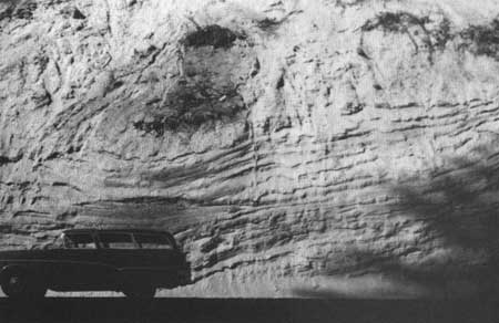
|
| Road cut in washed pumice deposit. |
The pumice accumulated to a depth of 5 feet in the immediate vicinity of Diamond Lake, Cinnamon Butte, Kelsay Point, and Windigo Pass. To the north and west the deposit becomes progressively thinner, and has a thickness of only 6 inches in the Fish Creek Desert and Toketee Falls areas. The 6-inch isopach line extends northeast to the vicinity of Bend, Oregon, some 70 miles from Mt. Mazama.
When the eruptions of pumice ceased, Mt. Mazama was silent for a period. Later, a few spurts of steam and pumice spouting from the vent signaled renewed activity. The eruptions rapidly increased in intensity; then came a series of stupendous explosions that must have been audible for hundreds of miles. A foamy mass of incandescent pumice and hot gas bubbled over the lip of the crater. Unable to overcome the force of gravity as had the earlier, less voluminous eruptions of pumice, the foamy mass rushed down into the valleys surrounding the volcano, with velocities approaching 100 miles per hour. This rushing cloud of frothy, glowing, pumice fragments and rapidly expanding gases—a glowing avalanche—enveloped the countryside.
The high content of hot gas gave the glowing avalanche extreme mobility. A portion of the gas and pumice that boiled over the lip of the volcano rushed down the Rogue River valley a distance of 35 miles; some flowed to the northeast as far as Chemult, 25 miles distant; and part of it flowed across the low saddle to the north of Mt. Mazama and rushed on toward Diamond Lake. The topography to the north of the saddle channeled the avalanche toward the south end of Diamond Lake. Somehow, the glowing avalanche passed over the surface of Diamond Lake, was funneled through the gap at the northwest corner of the lake, and continued down Lake Creek. Wells dug near the summer homes on the west side of Diamond Lake reveal the glowing-avalanche deposits in that area are between 25 and 30 feet thick. The avalanche flowed down Lake Creek as far as its confluence with the North Umpqua River. This is the present site of Lemolo Lake. Part of the material was diverted westward across Toolbox Meadows and continued down the drainage of Lava Creek and the Clearwater River. This fork of the avalanche came to rest about halfway between the Lake Creek drainage and Toketee Ranger Station.
It is not clear just how a glowing mass of pumice and gas could pass over the surface of a body of water such as Diamond Lake; but the evidence is clear—the amount of avalanche material exposed below Diamond Lake is sufficient to fill the lake, perhaps many times over. Two theories have been advanced, seeking to explain how this might have happened. One geologist has suggested that the first wave of pumice would have floated on the surface of the lake, providing a carpet across which successive waves flowed. The pumice is light enough to float on water; and the theory is plausible.
Another theory asserts the avalanche occurred during the winter when the lake was frozen. The rushing mass of hot gas and pumice presumably flowed over the ice, which was insulated from the intense heat by the 5-foot layer of airborne pumice that preceeded it. Adding strength to this theory is the fact that the winter winds in the Diamond Lake area blow toward the northeast, which is precisely the direction they must have been blowing at the time the airborne pumice was erupted from Mt. Mazama. As stated earlier, the airborne pumice stretches toward the northeast from Crater Lake. This theory, too, then, offers a possible answer to the puzzle.

|
| Road cut exposing charcoal logs in washed pumice deposit |
The pumice of the glowing-avalanche deposit is easily distinguished from that which earlier fell from the air. Whereas the airborne pumice is well sorted (i.e., all the particles are approximately the same size at a given point), the avalanche material consists of lumps of pumice of varying size, set in a matrix of very fine, dust-like pumice fragments. Some of the largest lumps of pumice have been found at the extreme limits of the avalanche deposits. The airborne pumice is a yellowish tan color; the avalanche pumice is usually pinkish tan. The pink coloration is the result of stains from the iron-bearing gases that it retained after coming to rest. As the glowing avalanche rushed down the stream drainage, it encountered thick forests, though timberline was then at a lower elevation than at present. The force of the avalanche bowled over even the largest trees and swept them along in the turbulent cloud. As the avalanche came to rest, the buried trees were carbonized by the intense heat retained by the pumice fragments and gases. Lumps of charcoal are found scattered through the deposit, and are exposed in road cuts near Clearwater Falls, Lemolo Lake, and White Horse Falls. This charcoal has been identified as remnants of pine and fir trees like those presently growing in the area.
Because the airborne pumice deposits and the glowing-avalanche deposits consist of soft, uncemented particles they are rapidly eroded and washed away by streams. Much of the material has been washed down the North Umpqua and Clearwater Rivers and has been redeposited in stratiform layers. Banks of washed pumice up to 100 feet thick are exposed in road cuts along the North Umpqua Highway west of Toketee Falls. A well dug at the Toketee Ranger Station cut through approximately 75 feet of this material. The washed pumice also contains charcoal fragments. These are abundant in several exposures, including those at Toketee Ranger Station and Slide Creek.
Radiocarbon dating has been performed on several charcoal specimens from the glowing avalanche deposit, though none of these was from the Diamond Lake area. The most reliable date yet obtained is 6,640 years ± 250 years B. P.1 This means the showers of pumice which fell on the Diamond Lake area, and the avalanche of scorching pumice which plunged rapidly down the drainages in the area, occurred about 6,640 years ago.
1Before Present
There is evidence that man watched the fiery holocaust in the area—at least from a distance. Charred Indian sandals have been found beneath the airborne pumice deposit near Paisley, some 80 miles east of the Crater Lake region. It is likely that some forest animals were trapped by the speeding glowing avalanche, but no remains have yet been uncovered in the Diamond Lake area.
Each day the streams remove a little more of the veiling mantle; and each new road cut exposes some new facet of the hidden past. The somber peaks and crystalline waters of the Diamond Lake area continue to reveal secrets jealously kept since their cataclysmic, formative days.
| <<< Previous | <<< Contents>>> | Next >>> |
diamond_lake_geology/sec3.htm
Last Updated: 01-Jul-2008