|
Marianas Trench Marine National Monument Commonwealth of the Northern Mariana Islands and Guam |
|
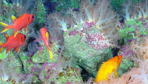 USF&WS photo | |
The total area of the Marianas Trench Marine National Monument consists of approximately 95,216 square miles (246,608 square kilometers) of submerged lands and waters of the Mariana Archipelago east of the Philippines. It is comprised of three units:
The Islands Unit, which includes the waters and submerged lands of Farallon de Pajaros (also known as Uracus), Maug, and Asuncion (the three northernmost Mariana Islands)
The Volcanic Unit or Arc of Fire Refuge, which includes the submerged lands within 1 nautical mile of 21 designated volcanic sites
The Trench Unit, which encompasses the submerged lands extending from the northern limit of the Exclusive Economic Zone (EEZ) in the Commonwealth of the Northern Mariana Islands (CNMI) to the southern limit of the EEZ of the United States in the Territory of Guam
The waters above the seafloor in the Volcanic and Trench Units are not included in the Monument. Additionally, the CNMI Government manages the terrestrial environment of Uracus, Maug, and Asuncion.
Established by Presidential Proclamation in January 2009, the Marianas Trench Marine National Monument is cooperatively managed by the Secretary of Commerce (NOAA), the Secretary of the Interior (U.S. Fish and Wildlife Service) and the Commonwealth of the Northern Mariana Islands (CNMI) Government, in cooperation with the Department of Defense and the Department of State.
Monument designation provides international, national, and local recognition that the Marianas is a refuge for seabirds, sea turtles, unique coral reefs, and a great diversity of seamount and hydrothermal vent life worth preservation.
The Marianas Trench Marine National Monument is geologically very complex, sporting a subduction zone, back arc basins, an active simmering island, and submarine volcanoes.
The crescent-shaped Mariana Trench (part of the Trench Unit) is the "Grand Canyon" of the ocean (actually 120 times larger) and includes some of the deepest known areas on Earth. Challenger Deep, the deepest part of the Mariana Trench and the greater ocean, is located at a depth of about 36,000 feet (around 11,000 meters) — about 7,000 feet deeper than Mount Everest is tall.
The Volcanic Unit includes a series of undersea mud volcanoes and thermal vents that support unusual life forms in some of the harshest conditions on Earth. Species are able to survive here despite hydrothermal vents that produce highly acidic and boiling water.
The Champagne vent, found at the NW Eifuku volcano, produces almost pure liquid carbon dioxide (CO2); it’s one of only two known liquid CO2 sites in the world. A pool of liquid sulfur at the Daikoku submarine volcano is also one of a kind — the only other known location of molten sulfur is on Jupiter’s moon Io.
In the Islands Unit, unique reef habitats support marine biological communities dependent on basalt rock foundations, unlike those throughout the remainder of the Pacific. These reefs and waters are among the most biologically diverse in the Western Pacific and include some of the greatest diversity of seamount and hydrothermal vent life yet discovered. They also contain one of the most diverse collections of stony corals in the Western Pacific.
The submerged caldera (volcanic crater) at Maug is one of only a few known places in the world where photosynthetic and chemosynthetic communities (those that make food from light and inorganic chemicals, respectively) co-exist. The caldera is approximately 1.5 miles (2.4 kilometer) wide and 820 feet (250 meter) deep, with very steep inner walls. In the center of the crater, a coral-topped lava dome rises to within 65 feet (20 meter) of the surface, while deep hydrothermal vents along the northeast side of the dome emit low-temperature water that influences the deep-water composition. Shallow warm water and gas vents near the mid-point of the inner East Island have a localized negative impact on the otherwise thriving coral reef system at Maug. Volcanic vents within the caldera provide scientists with an in situ (in the field) laboratory for the changes that will likely occur in coral reef ecosystems from ocean acidification and rising water temperatures associated with global warming.
Elsewhere within the Islands Unit, coral reef ecosystems have high numbers of apex predators (sharks and jacks), larger than anywhere else along the Mariana Archipelago, with one site having the highest density of sharks anywhere in the Pacific. Similarly, these northern islands have the highest large fish biomass (total mass of fish in a given volume) in the Mariana Islands. The rare bumphead parrotfish (the largest parrotfish species), lives in these waters.
Source: NOAA Website (May 2023)
|
Establishment Marianas Trench Marine National Monument — January 5, 2009 |
For More Information Please Visit The   OFFICIAL WEBSITES |
Brochures/Site Bulletins

Documents
Exploring Public Knowledge, Attitudes, and Perceptions of the Marianas Trench Marine National Monument (Dawn M. Kotowicz, Laurie Richmond and Justin Hospital, extract from Coastal Management, 2017)
Fact Sheet (2012)
Proclamation 8335—Establishment of the Marianas Trench Marine National Monument (George W. Bush, January 6, 2009)
Traditional Fishing in the Islands unit of the Mariana Trench Marine National Monument (undated)
First Voyage to the Marianas Trench Marine National Monument
Books
marianas-trench/index.htm
Last Updated: 24-May-2023