| |
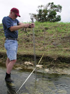
In March 2004, scientists from the US Geological Survey (USGS), in cooperation with Natural Resources Staff at War in the Pacific NHP, mapped and completed a preliminary inventory of the park’s streams. This is the first work to focus specifically on the park’s streams, and represents a significant and important step in improving the management of the park’s resources.
 Streams are the primary connection between land and ocean in the park, and they are responsible for transporting sediments, nutrients, contaminant, and fresh water onto the park's nearshore coral reefs. Without baseline data, the park cannot effectively determine the effect of upland erosion and other impacts on their marine resources. Streams are the primary connection between land and ocean in the park, and they are responsible for transporting sediments, nutrients, contaminant, and fresh water onto the park's nearshore coral reefs. Without baseline data, the park cannot effectively determine the effect of upland erosion and other impacts on their marine resources.
Over the course of a week, researches hike each of the major streams in the park, including both forks of the Asan River and southern fork of the Togcha River in Agat. Along the way they mapped streams into GIS and gathered information on streambed morphology, erosion patterns, bedrock composition, stream flow rates, animal life, and human alterations.
Researchers were saddened to see a large amount of garbage in the streams, even near the headwaters, which they expected to be free human of impacts. Significant erosional gullies were also observed in many streams, probably the result of recent typhoons on the island. But not everything was bad in the streams. Several impressive waterfalls were located, and diversity of aquatic wildlife was observed (but not sampled), giving hope for the future of the park's streams.
Dwayne Minton, Ph.D.
|
|