|
Wind Cave National Park South Dakota |
|
 NPS photo | |
". . . we made our way down the stairway against the very strong wind and then began our descent proper, into the wonderful, indescribably wonderful cave—down, down into the very 'bowels of the earth.'"
—An early explorer of Wind Cave, 1890
What tempted the first explorers of Wind Cave to leave behind their safe, familiar world and venture into the dark, unknown, almost lifeless depths of Wind Cave? Was it a search for hidden natural treasures? Curiosity? Was it the thrill of going where no man or woman had gone before?
Records of the earliest excursions into Wind Cave suggest that people entered the cave for all these reasons. Today visitors come to Wind Cave National Park to meander through some of the cave's more than 100 miles of passageways seeking similar experiences.
Don't let the park's name fool you, There is much more to Wind Cave National Park than its underground geological wonders. A diverse mix of wildlife, including bison, pronghorn, and prairie dogs, lives in the 28,295 acres of rolling grasslands, pine forests, hills, and ravines that make up its sunlit upper layer. Here you can see a small remnant of the prairie and imagine the scene that greeted westward-bound 19th-century pioneers—not farms and cities, as today, but open plains stretching across the middle of the continent. A piece of that prairie is preserved here in an almost natural state.
The Wind Cave area has been protected since 1903, when it became our seventh oldest national park. Regarded as sacred by American Indians, the cave was not found by settlers until 1881, when two brothers, Jesse and Tom Bingham, heard a loud whistling noise. The sound led them to a small hole in the ground, the cave's only natural opening. A wind was said to blow with such force out of the hole that it knocked Jesse's hat off. That wind, which gave the cave its name, is created by differences between atmospheric pressures in the cave and outside. This wind can still be noticed at the cave entrance.
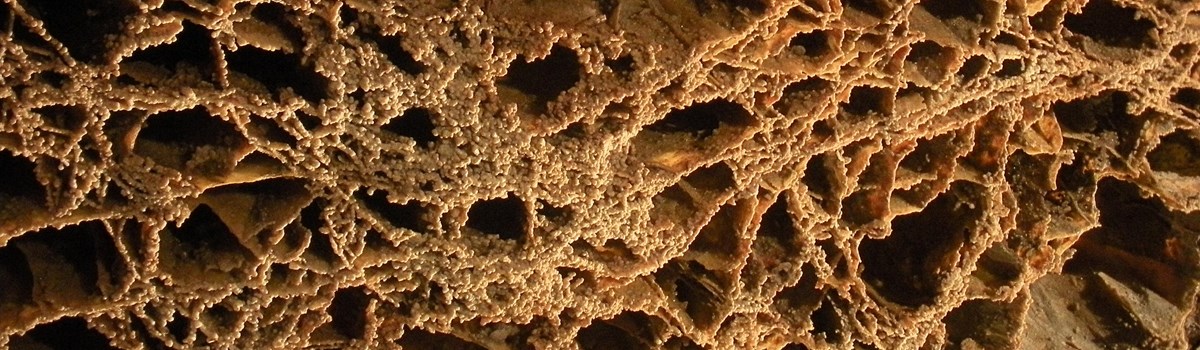
It was left to later adventurers like Alvin McDonald to follow that wind and discover the cave's extensive network of passageways containing boxwork, popcorn, and frostwork formations and other delicate, irreplaceable features. Young Alvin and others who explored the cave before 1900 were fascinated by what they found: chocolate-colored crystals, formations resembling faces or animals, and chambers that inspired names such as the Garden of Eden and the Dungeon. Reports of these discoveries drew a stream of curious tourists to the cave. Local entrepreneurs, including the McDonald family, blasted open passages and guided tourists through for a fee. Cave specimens were removed and sold. Today the cave's fragile features are protected.
To witness the beginning of the formation of Wind Cave, one of the world's oldest caves, you would have to have been here 320 million years ago. Parts of the limestone that constitute the upper levels of Wind Cave were then being dissolved into cave passageways. As ancient ocean levels fluctuated, these passages were filled with sediments. Beneath the ocean a thick layer of sediments continued to be deposited above that limestone.
About 60 million years ago, the forces that uplifted the Rocky Mountains also uplifted the modern Black Hills, producing large fractures and cracks in the overlying limestone. Over millions of years, water moving slowly through those cracks dissolved the limestone to produce the complex maze of the cave's passages.
Later erosion changed surface drainage patterns, which caused subsurface water levels to drop, draining the cave passages. As the modern Wind Cave formed, many of these newer passages intersected the older filled cave, revealing the red clay and sandstone sediments from 320 million years ago. A three-dimensional network of passages formed, creating one of the most complex caves in the world.
Also exposed were some of the most prominent features in Wind Cave—the boxwork—thin, honeycomb-shaped structures of calcite that protrude from the walls and ceilings. Although Wind Cave has few stalactites and stalagmites, many unusual formations and a variety of minerals are found in the cave. The complex geology of the cave, the profusion of boxwork, and the variety of minerals make Wind Cave a world-class cave.
You might wonder if after more than 100 years of exploration there is anything new to discover in Wind Cave. Barometric wind studies estimate that approximately five percent of the total cave has been discovered. In 1891 Alvin McDonald wrote in a diary of his cave trips: "Have given up the idea of finding the end of Wind Cave." The better-equipped cavers of today have not given up. They continue to push farther and farther into the cave's cool, black recesses.
A Sanctuary for Wildlife
Vast open prairies can look deceptively empty. But take a closer look. A small dark shape on the horizon may be a bison grazing knee-deep in bluestem and other grasses. You may glimpse a well camouflaged coyote hunting among the prairie dog "towns." Slowly comes the realization that the nutrient-rich plants of the plains support an abundance of wildlife. When first established, Wind Cave National Park's main purpose was to protect the cave and help visitors enjoy it. But by 1912 the protection and reestablishment of native wildlife within the park was recognized as an equally important goal.
Among the park's foremost missions as a wildlife sanctuary was the restoration of populations of bison, elk, and pronghorn to the Black Hills. By the late 1880s these animals had been eliminated from this part of their range, largely because of human predators. The story of the bison's return reflects the success of the park's management programs. Starting with 14 bison donated by the Bronx Zoo in 1913, the herd numbers about 350 today.
Other wildlife, including mule deer, cottontail rabbits, and many species of birds, live in the prairies, forests, and hills of Wind Cave. Located nearly at mid-continent, the park embraces animal and plant species common to both the East and West. Don't be surprised to see ponderosa pines and pinyon jays—western natives—alongside American elms and eastern bluebirds.
Safety and Regulations
To protect yourself and park wildlife, always view animals at a safe
distance and stay alert. Bison and other animals are wild and
unpredictable and can attack if startled. Hunting, chasing, or harassing
wildlife is prohibited; guns and other weapons must be packed away to
prevent their use. Feeding wild animals is prohibited; even small
animals such as prairie dogs may bite. Watch for rattlesnakes, which
sometimes live in prairie dog burrows and can strike without
warning.
Exploring Wind Cave and the Black Hills
Touring the Southern Black Hills
There is a lot to see and do at Wind Cave National Park and in the surrounding area.
Several scenic roadways lead through the Black Hills to the park. Sightseers especially enjoy the Wildlife Loop Road, Iron Mountain Road, and Needles Highway. They wind through pine-spruce forests, meadows, mountains and pinnacles of granite, and lands populated by bison, pronghorn, deer, and prairie dogs. Ask about these and other travel routes.
Wind Cave country has many places of natural, historical, and scenic interest. Custer State Park and Black Hills National Forest, adjacent to Wind Cave, offer outdoor recreation opportunities. These two wild areas' one million-plus acres offer some 30 campgrounds; many lakes for boating, swimming, and trout fishing; trails for hiking and horseback riding; and picnic areas.
Within 50 miles of Wind Cave there are two National Park System areas. Jewel Cave National Monument preserves more than 125 miles of cave decorated with sparkling jewel-like calcite crystals and varied cave formations; cave tours are given. Mount Rushmore National Memorial features the monumental sculpture of American presidents Washington, Jefferson, Lincoln, and Theodore Roosevelt.
Many area communities, including Custer, Hot Springs, and Rapid City; some smaller towns; and Custer State Park, provide lodging, grocery and camping supply stores, gasoline stations, and other services seasonally or all year. Private campgrounds are available, too. There are no lodging facilities or grocery services in the national park. Warning The tunnels on the Iron Mountain Road (U.S. 16A) are 12' 6" high and 13' 6" wide, and those on the Needles Highway/Sylvan Lake Road (S.D. 87) are as low as 10' 8" and as narrow as 8' 7".
Visiting the Park
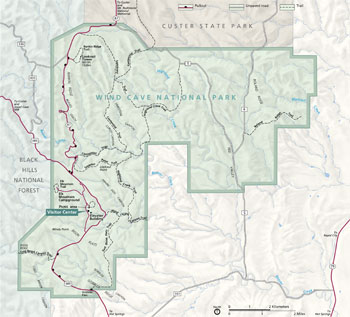   (click for larger maps) |
Visitor Center The visitor center offers books, brochures, exhibits, and audio-visual programs about the cave and park. Cave tour information and tickets are available. Schedules of activities such as talks and nature walks are posted. Limited vending service is available. The center is open daily except Thanksgiving, December 25, and January 1.
Park Roads Sightseeing along park roads enables you to enjoy views of the Black Hills and see bison, pronghorn, and other wildlife. Pull into a parking area to enjoy the scenery safely. Bicycling is permitted only on park roadways. Backcountry biking is prohibited.
Camping/Picnic Areas Elk Mountain Campground, in hills of ponderosa pine forest and prairie, has 75 sites for tents and recreational vehicles. The campground is open April through October, first-come, first-served. Picnic tables, fire grills, water, and restrooms are provided; fees are charged. Campfire programs are given at the amphitheater in summer. Backcountry camping is allowed; a permit is required. The picnic area, located in a ponderosa pine woodland, has tables and water in the summer.
Trails Three self-guiding trails help you explore the park's grasslands and ponderosa pine forests. Trail booklets are available at the visitor center or trailheads. Rankin Ridge Trail (1¼ miles) climbs to the top of Rankin Ridge, highest point in the park, for panoramic views of the Black Hills country from a ridgetop fire lookout. The Elk Mountain Trail (one mile) offers a mildly strenuous walk circling the campground. Hikers may travel cross-country or explore on 30 miles of hiking trails that include the southern terminus of the 111-mile Centennial Trail.
Safety and Regulations The danger of wildfire is high year-round. Build fires only in the campground and in fire grills or campstoves. Never leave a fire unattended. Pets must be physically restrained at all times and are not permitted in buildings, the backcountry, or cave. Off-road driving is prohibited. Avoid contact with poison ivy.
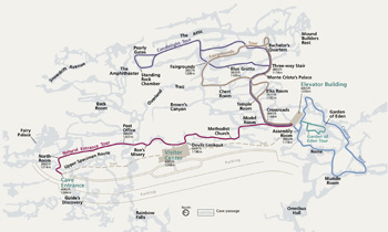
Touring the Cave
Scheduled, ranger-led tours of Wind Cave are offered all year; fees are charged. The cave is closed on Thanksgiving, December 25, and January 1. Cave tour tickets and information are available at the visitor center. All tours begin there.
Approximately eight of the more than 100 miles of known passages in Wind Cave are on the map.
Three cave tours are available—two tours are 0.5 mile, and one tour is 0.25 mile—that follow paved and lighted walkways through underground passages decorated with boxwork and other fascinating cave formations. The Natural Entrance Tour and the Fairgrounds Tour last from 1¼ to 1½ hours and require negotiating 300 to 450 stairs. The shorter Garden of Eden Tour lasts about one hour and includes 150 stairs.
Two special tours are offered from mid-June to mid-August. The one-mile Candlelight Tour allows visitors to experience Wind Cave as early visitors may have. Most of the tour route follows passages where the only light comes from hand-held candle lanterns. Bending, stooping, and stair-climbing are required on this two-hour cave tour.
Another special tour, the Caving Tour, lets visitors experience what it is like to explore a wild 3,000-foot passage of Wind Cave. Participants must be physically fit, because a lot of crawling is required on this three- to four-hour trip.
Reservations for special tours are required and may be made no sooner than one month in advance. Contact the park for reservations or information about proper clothing, caving gear, and age restrictions. A short cave visit for visitors with special needs may be arranged at the visitor center.
Safety and Regulations
Portions of the cave tour routes may be uneven or wet and slippery.
Watch your step and wear low-heeled, non-slip shoes. The cave
temperature is always 53°F; wear a jacket or sweater. If you have
breathing, heart, or walking problems, or are claustrophobic, ask your
doctor before taking a tour. The cave's delicate formations are easily
broken or discolored by skin oils; please do not touch. Smoking, food,
and drink are prohibited.
Source: NPS Brochure (2004)
|
Establishment
National Game Preserve — August 10, 1912 |
For More Information Please Visit The  OFFICIAL NPS WEBSITE |
Documents
75 Years at Wind Cave: A History of the National Park (John Bohi, extract from South Dakota Historical Collections, Vol 31, 1962)
A Brief History of Wind Cave National Park (revised 2017)
A History of Animal Management at Wind Cave National Park (Kim Mogen, May 1977)
A Preliminary Study of Small Mammal Presence and Response to Plague Control at Wind Cave National Park NPS Natural Resource Technical Report NPS/WICA/NRTR-2013/697 (Daniel S. Licht, 2013)
Adapting to Endure: The Early History of Wind Cave National Park, 1903-1916 (Kathy S. Mason, extract from South Dakota History, Vol. 32 No. 2, Summer 2002, ©South Dakota Historical Society)
Air pressure propagation through Wind Cave and Jewel Cave: How do pressure waves travel through barometric caves? (Annika K. Gomell, Daniel C. Austin, Marc J. Ohms and Andreas Pflitsch, extract from International Journal of Speleology, Vol. 50 No. 3, September 2021)
Adapting to Endure: The Early History of Wind Cave National Park, 1903-1916 (Kathy S. Mason, extract from South Dakota History, Vol. 32 No. 2, Summer 2002, ©South Dakota State Historical Society)
American bison behavior patterns at Wind Cave National Park (Milo Jack Shult, 1972)
Bison Management Plan, Wind Cave National Park (December 2006)
Black Hills Symposium (Jim Pisarowicz, ed., The NSS Bulletin: Journal of Caves and Karst Studies, Vol. 51 No. 2, December 1989, ©The National Speleological Society)
Introduction (Jim Pisarowicz, extract from The NSS Bulletin, 51(2), December 1989)
Geologic History of the Black Hills Caves, South Dakota (©Arthur N. Palmer and Margaret V. Palmer, extract from The NSS Bulletin, 51(2), December 1989)
Features of the Genesis of Jewel Cave and Wind Cave, Black Hills, South Dakota (Derek C. Ford, extract from The NSS Bulletin, 51(2), December 1989)
Evidence of Quaternary Tectonic Activity, and for Regional Aquifer Flow at Wind Cave, South Dakota (Thomas E. Miller, extract from The NSS Bulletin, 51(2), December 1989)
Helictite Bushes—A Subaqueous Speleothem? (©Donald G. Davis, extract from The NSS Bulletin, 51(2), December 1989)
Wind Cave, South Dakota: Temperature and Humidity Variations (©James Nepstad and James Pisarowicz, extract from The NSS Bulletin, 51(2), December 1989)
Use of Electronic Data-Logging Equipment to Monitor Hydrologic Parameters in a Humid Cave Environment in Wind Cave National Park, South Dakota (Earl A. Greene, extract from The NSS Bulletin, 51(2), December 1989)
Black-footed Ferret Reintroduction Plan, Draft Environmental Assessment, Wind Cave National Park, South Dakota (November 2006)
Black-tailed Prairie Dog Management Plan, Draft Environmental Assessment, Wind Cave National Park, South Dakota (January 2006)
Boundary Expansion Study Environmental Assessment, Wind Cave National Park (engineering-environmental Management, Inc., June 2002)
Building a Vacationland: Tourism Development in the Black Hills during the Great Depression (Suzanne Barta Julin, extract from South Dakota History, Vol. 35 No. 4, Winter 2005, ©South Dakota Historical Society)
Casey Addition Visitor Use Plan/Environmental Assessment, Wind Cave National Park (October 2014)
Cave and Karst Resource Management Plan, Wind Cave National Park (March 2007)
Cave Water Quality Monitoring for Wind Cave National Park: 2021 Data Report NPS Natural Resource Data Series NPS/WICA/NRDS-2022/1374 (Anine T. Rosse, November 2022)
Condition Assessment of Streambanks and Streamside Vegetation on Perennial Streams in Wind Cave National Park: 2009-2012 NPS Natural Resource Technical Report NPS/WICA/NRTR—2013/758 (Beth A. Burkhart and Kevin L. Kovacs, June 2013)
Cultural Landscape Report, Wind Cave National Park (John Milner Associates, Inc., May 2005)
Cultural Landscapes Inventory: Wind Cave National Park Cultural Landscape (2021, rev. Sep. 2020)
Dye Tracing Through the Vadose Zone Above Wind Cave, Custer County, South Dakota (James Nepstad, extract from NCKRI Symposium 5: Proceedings of the 14th Multidisciplinary Conference on Sinkholes and the Engineering and Environmental Impact of Karst, 2015, ©National Cave and Karst Research Institute)
Dynamic Climatologic Processes of Barometric Cave Systems Using the Example of Jewel Cave and Wind Cave in South Dakota, USA (Andreas Pflitsch, Mike Wiles, Rodney Horrocks, Jacek Paisecki and Julia Ringeis, extract from Acta Carsologica, Vol 39 No. 3, 2010)
Excerpts From Warren, Hayden, Grinnell, Dodge, Ewers, Seton and Others, Wind Cave NP (William J. Watson, December 1943)
Final General Management Plan/Environmental Impact Statement, Wind Cave National Park, South Dakota (June 1994)
Forest Structure and Fuel Loads at Wind Cave National Park: 2012 Status Report NPS Natural Resource Technical Report NPS/NGPN/NRTR-2013/776 (Isabel W. Ashton, Michael Prowatzke, Stephen K. Wilson, Phil Graeve and Dan Swanson, July 2013)
Forest Structure and Fuel Loads at Wind Cave National Park: 2017 Status Report NPS Natural Resource Report NPS/NGPN/NRR-2019/1950 (Isabel W. Ashton, Christopher J. Davis and Dan Swanson, 2019)
Foundation Statement, Wind Cave National Park, South Dakota (Draft, September 2011)
Foundation Document Overview, Wind Cave National Park, South Dakota (June 2014)
Geochemical Investigation of the Madison Aquifer, Wind Cave National Park, South Dakota NPS Natural Resource Technical Report NPS/NRPC/WRD/NRTR-2011/416 (Jennifer Back, January 2011)
Geologic Map of Wind Cave National Park (January 2009)
Geologic Map of Wind Cave National Park (Brian A. Fagnan, Beth Z. Lincoln and Timothy N. Lincoln, South Dakota Department of Environment & Natural Resources Geological Survey, 2011)
Geologic Resources Inventory Report, Wind Cave National Park NPS Natural Resource Report NPS/NRPC/GRD/NRR-2009/087 (March 2009)
Geological Map of the Black Hills of Dakota (Henry Newton, 1879)
Geology and Water Resources of the Northern Portion of the Black Hills and Adjoining Regions in South Dakota and Wyoming USGS Professional Paper 65 (N.H. Darton, 1909)
Groundwater Flow, Quality (2007–10), and Mixing in the Wind Cave National Park Area, South Dakota USGS Scientific Investigations Report 2011–5235 (Andrew J. Long, Marc J. Ohms and Jonathan D.R.G. McKaskey, 2012)
Herd Organization and Movements in Wind Cave National Park, South Dakota NPS Natural Resources Report No. 13 (Kenneth L. Varland, Allan L. Lovaas and Robert B. Dahlgren, 1978)
Historic Context Report for the Potential Linear Historic Road Corridor Along South Dakota (SD) 87 in Wind Cave National Park (Mark David Spence, March 2011)
Historic Contexts and National Register Guidelines, Wind Cave National Park (Barbara Beving Long, 1992)
History of the Wind Cave National Game Preserve, South Dakota (Clara Ruth, comp., December 1921)
Junior Cave Scientist Activity Book (Ages 5-12+) (2016; for reference purposes only)
Junior Ranger Activity Book, Wind Cave National Park (Date Unknown; for reference purposes only)
Large Springs in the Black Hills, South Dakota and Wyoming South Dakota Geological Survey Report of Investigations No. 107 (Perry H. Rahn and J.P. Gries, 1973)
Long-Range Interpretive Plan, Wind Cave National Park (February 2012)
Metal and Glass: An Investigation of Possible Historic Period Native American Sites in Wind Cave National Park (©Morgan Beyer, Master's Thesis, December 2016)
Monitoring Bird Populations in Wind Cave National Park: 2009 (Rocky Mountain Bird Observatory, January 2010)
Monitoring Residual Herbage in Wind Cave National Park 2010–2013 Using Modified Robel Pole Protocol Calibrated for the Southern Black Hills NPS Natural Resource Data Series NPS/WICA/NRDS—2014/641 (Beth A. Burkhart and Kevin L. Kovacs, April 2014)
Mountain Pine Beetle Risk Assessment and Response Strategy, Wind Cave National Park (March 2012)
Multivariate Analysis of Hydrochemical Data for Jewel Cave, Wind Cave, and Surrounding Areas NPS Natural Resource Report NPS/JECA/NRR—2019/1883 (Andrew J. Long, James B. Paces and William G. Eldridge, March 2019)
National Register of Historic Places Nomination Forms
Administrative and Utility Area Historic District (Ken Karsmizki, February 1994)
Beaver Creek Bridge (Carolyn Torma, June 23, 1982)
Beaver Creek Rockshelter (39CU779) (Betty J. LeFree and Robert Alex, 1993)
Pig Tail Bridge (Ken Karsmizki, February 1994)
Wind Cave National Park Multiple Property Submission (Kenneth W. Karsmizki, November 1993)
Natural Resource Condition Assessment, Wind Cave National Park NPS Natural Resource Report NPS/WICR/NRR-2011/478 (Barry Drazkowski, Michael R. Komp, Kevin Stark, Andy J. Nadeau, Shannon Amberg, Eric Iverson, Lucas Danzinger and Lindsey Danielson, December 2011)
Observations of Bobcats, Lynx rufus, Hunting Black-Tailed Prairie Dogs, Cynomys ludovicianus, in Western South Dakota (Daniel S. Licht, extract from The Canadian Field-Naturalist, Vol. 124 No. 3, 2010, ©The Ottawa Field-Naturalists' Club)
Optimizing DNA Extraction from Microorganisms Living in Wind Cave (©Allison Warming, Thesis University of Northern Iowa, May 2021)
Paleontological Resource Inventory (Public Version), Wind Cave National Park NPS Natural Resource Report NPS/WICA/NRR-2023/2536 (Theodore Herring, Justin S. Tweet and Vincent L, Santucci, June 2023)
Park Newspaper (Passages — A Visitor's Guide to Wind Cave National Park): 2001 • 2002 • 2003 • 2004 • 2005 • 2006 • 2007 • 2008 • 2009 • 2010 • 2011 • 2012 • 2013 • 2014 • 2015 • 2016 • 2017 • 2021 • 2024
Passages Through Many Worlds: Historic Resource Study of Wind Cave National Park (Mark David Spence, 2011)
Plant Community Composition and Structure Monitoring
Plant Community Composition and Structure Monitoring Protocol for the Northern Great Plains I&M Network Version 1.01 NPS Natural Resource Report NPS/NGPN/NRR-2012/489.1 (Amy J. Symstad, Robert A. Gitzen, Cody L. Wienk, Michael R. Bynum, Daniel J. Swanson, Andy D. Thorstenson and Kara J. Paintner-Green, February 2012)
Plant Community Composition and Structure Monitoring for Wind Cave National Park: 2011 Annual Report NPS Natural Resource Data Series NPS/NGPN/NRTR-2012/534 (Isabel W. Ashton, Michael Prowatzke, Michael R. Bynum, Tim Shepherd, Stephen K. Wilson and Kara Paintner-Green, January 2012)
Plant Community Composition and Structure Monitoring for Wind Cave National Park: 2012 Annual Report NPS Natural Resource Data Series NPS/NGPN/NRTR-2013/678 (Isabel W. Ashton, Michael Prowatzke and Stephen K. Wilson, January 2013)
Plant Community Composition and Structure Monitoring for Wind Cave National Park: 2013 Annual Report NPS Natural Resource Data Series NPS/NGPN/NRDS-2014/613 (Isabel W. Ashton and Michael Prowatzke, January 2014)
Plant Community Composition and Structure Monitoring for Wind Cave National Park: 2014 Annual Report NPS Natural Resource Data Series NPS/NGPN/NRDS-2015/765 (Michael Prowatzke and Stephen K. Wilson, March 2015)
Plant Community Composition and Structure Monitoring for Wind Cave National Park: 2011-2015 Summary Report NPS Natural Resource Data Series NPS/NGPN/NRR-2016/1236 (Isabel W. Ashton and Christopher J. Davis, June 2016)
Plant Community Composition and Structure Monitoring for Wind Cave National Park: 2016 Data Report NPS Natural Resource Data Series NPS/NGPN/NRDS-2017/1090 (Stephanie L. Rockwood and Daniel J. Swanson, March 2017)
Plant Community Composition and Structure Monitoring for Wind Cave National Park: 2018 Data Report NPS Natural Resource Data Series NPS/NGPN/NRDS-2019/1197 (Ryan M. Manuel and Daniel J. Swanson, January 2019)
Plant Community Composition and Structure Monitoring for Wind Cave National Park: 2019 Data Report NPS Natural Resource Data Series NPS/WICA/NRDS-2019/1247 (Theresa L. Schaffner, Daniel J. Swanson and Stephanie L. Rockwood, December 2019)
Poster: Wind Cave (2009)
Preliminary Description of the Geology and Water Resources of the Southern Half of the Black Hills and Adjoining Regions in South Dakota and Wyoming (Nelson Horatio Darton, extract from Twenty-First Annual Report of the United States Geological Survey to the Secretary of the Interior 1899-1900: Part IV—Hydrography, 1901)
Range ecology of bison on mixed grass prairie at Wind Cave National Park (©Jewel Kay Popp, Master's Thesis, 1981)
Rankin Ridge Lookout Tower, Wind Cave National Park, Assessment of Qualifications for Listing on National Register of Historic Places (Mark David Spence, September 27, 2010)
Report of the Acting Superintendent of the Wind Cave National Park: 1914 (HTML edition) (Frederick N. Dille, 1914)
Report of the Supervisor of the Wind Cave National Park: 1915 (HTML edition) (T.W. Brazell, 1915)
Report on Wind Cave, Crater Lake, Sullys Hill, and Platt National Parks, and Casa Grande Ruin — 1909 (1909)
Report on Wind Cave National Park, Sullys Hill Park, Casa Grande Ruin, Muir Woods, Petrified Forest, and Other National Monuments, Including List of Bird Reserves — 1913 (HTML edition) (1914)
Statement for Management — Wind Cave National Park (July 1986)
Statement for Management: 1994, Wind Cave National Park (April 1994)
Streamflow and Water-Quality Characteristics for Wind Cave National Park, South Dakota, 2002-03 USGS Scientific Investigations Report 2004-5071 (Allen J. Heakin, 2004)
The Archeology of Beaver Creek Shelter (39CU779): A Preliminary Statement Selections from the Division of Cultural Resources, Rocky Mountain Region No. 3 (Lynn Marie Alex, June 1991)
The Home of the Bison: An Ethnographic and Ethnohistorical Study of Traditional Cultural Affiliations to Wind Cave National Park: Volume One (Patricia C. Albers, September 29, 2003)
The Natural History Story of Wind Cave National Park (John A. Tyers, c1960s)
Thermal genesis of dissolution caves in the Black Hills, South Dakota (M.J. Bakalowicz, D.C. Ford, T.E. Miller, A.N. Palmer and M.V. Palmer, extract from Geological Society of America Bulletin, Vol. 99, December 1987)
Topographic Map: Wind Cave National Park & Vicinity, SD Scale: 1:24,000 (USGS, 1961)
Two Approaches for Incorporating Climate Change into Natural Resource Management Planning at Wind Cave National Park NPS Natural Resource Technical Report NPS/WICA/NRTR—2014/918 (Amy J. Symstad, Andrew J. Long, John F. Stamm, David A. King, Dominique M. Bachelet and Parker A. Norton, October 2014)
Use of Chemical Fire Retardant at Wind Cave National Park (Deane Schilts, March 1975, rev. October 1977)
Vegetation Projections for Wind Cave National Park with Three Future Climate Scenarios NPS Natural Resource Technical Report NPS/WICA/NRTR-2013/681 (David A. King, Dominique M. Bachelet and Amy J. Symstad, January 2013)
Water Resources of Wind Cave National Park NPS Natural Resource Report NPS/WICA/NRR-2016/1247 (Marc J. Ohms, July 2016)
Water-Supply Sites for Wind Cave National Park, Custer County, South Dakota USGS Open-File Report (Donald G. Adolphson and E.F. Le Roux, 1974)
Where the Earth Breathes Inside: The Attitudes of Lakota People Toward Wind Cave National Park (©Adam Rossi, M.S. Thesis, Davis College of Agriculture, 2017)
White-Nose Syndrome Surveillance Across Northern Great Plains National Park Units: 2018 Interim Report (Ian Abernethy, August 2018)
Wind Cave National Park Black-Footed Ferret Reintroduction — 5-Year Review NPS Natural Resource Report NPS/WICA/NRR-2015/916 (Travis M. Livieri, Barbara L. Muenchau, Daniel E. Roddy and Daniel S. Licht, February 2015)
Wind Cave National Park, South Dakota NPS Handbook 104 (1979)
Zoning Management Plan/General Management Plan Amendment/Environmental Assessment, Wind Cave National Park (August 2015)
wica/index.htm
Last Updated: 01-Jan-2025