|
Wupatki National Monument Arizona |
|
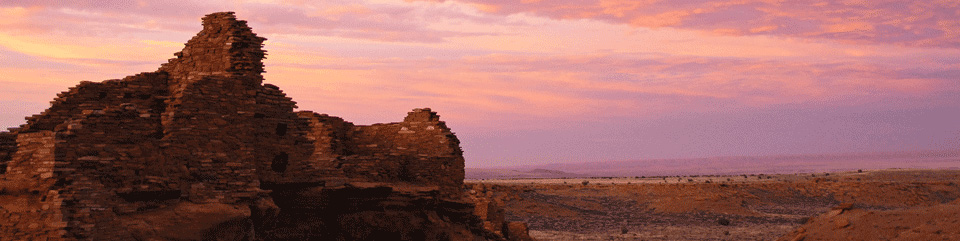 NPS photo | |
Life in a Changing Landscape
The people living just northeast of what is now Flagstaff, Ariz., must have been warned by tremors before debris exploded from the ground and rained down on their pithouses. The lava flows and erupting cinders that followed forced these farmers to vacate the rocky lands they had cultivated for 400 years. A few generations later, at Wupatki and nearby Walnut Canyon, families returned to grow crops for another 100 years in the shadow of Sunset Crater. Slowly, plants and animals returned too, some specially adapted to living on the lava. By the late 1800s ranching and logging operations sustained the new populations settling Flagstaff, and the memory of the most recent eruption on the Colorado Plateau lived only in the stories of indigenous Southwest people. Today occasional earthquakes still remind local residents that they live in a geologically active area. At Wupatki and Sunset Crater Volcano national monuments, we contemplate how the environment and people change each other.
The remains of masonry pueblos, or villages, that dot the landscape of Wupatki are the most obvious evidence of the human endeavor in this expansive land. They tell of the 1100s when puebloan peoples came together to build a vast farming community. Some of these villagers may have migrated from drought-stressed areas on the Colorado Plateau to join people already living here. With the first eruption of Sunset Crater, the agricultural potential improved because the thin ash layer absorbed precious moisture and helped prevent evaporation, and a climate change provided more rainfall during the growing season.
By 1180 thousands of people were farming on the Wupatki landscape. By 1250, when the volcano had quieted, pueblos stood empty. The people of Wupatki had moved on and established new homes. Many people traversed the high deserts of the Colorado Plateau over time, but few stayed long. Those who did adapted to the region's challenging environment. Their descendants still live nearby, including Hopi, Zuni, and Navajo people.
Nineteenth-century explorers such as John Wesley Powell marveled at the well-preserved pueblos and the stark but strangely beautiful volcanic landscape. With the founding of Flagstaff, travelers sought out these local attractions. Early visitors explored the lava flows and took rocks for souvenirs. Others looted the archeological sites. In 1928 filmmakers wishing to create a landslide at Sunset Crater inadvertently created a national monument instead. Activists, fearing irreversible damage to the volcano, pushed for protection of the area; and, in 1930, President Hoover established Sunset Crater National Monument (later renamed Sunset Crater Volcano National Monument) as part of the National Park System. Years and thousands of volcano-climbing visitors later, the scarred mountain was closed to climbers. Now this cinder cone is recovering. Other nearby volcanoes, which are not in the park, are mined for pumice and cinders or used for off-road recreation.
Each time a volcano erupts, life begins anew. Like farming the high desert of Wupatki, establishing life in this environment may seem an impossible challenge. But a closer look reveals a pink penstemon radiant against the black rock, its species unique to this rugged terrain. Ponderosa pines, their growth stunted by harsh conditions, offer habitat for Abert's squirrels. Lichen adds a touch of color and slowly converts rock to soil. The volcanic landscape reminds us that only change is constant. It is mute testimony to the forces that will undoubtedly affect the land and its inhabitants again.
Wupatki: A Mosaic of Southwestern Cultures
The past peoples of Wupatki lived as beneficiaries of the land over which they made epic migrations. In a region of scarce water and climate extremes, they developed self-sustaining cultural and economic systems. The result is a complex story of people interacting with their environment and with each other to live successfully where many would not.
Imagine raising corn planted in nutrient-poor soils, in a land where tantalizing thunderstorms build—but often cheat crops of rain. Despite a beneficial ash fall from Sunset Crater, farming at Wupatki during the 1100s was decidedly marginal. Only the diligent succeeded, and trade with others was vital. Archeologists coined the term Sinagua for the cultural tradition of this area, reflecting the people's ability to farm and live virtually "without water."
Life here involved sharing and trading. Located at the crossroads between Sinagua, Cohonina, and Kayenta Anasazi cultural traditions, Wupatki exhibits a unique cultural brew. We see the exchange of ideas in homes built the Anasazi way but furnished with Sinagua-style pottery, textiles, and tools. Archeologists still debate whether this represents different cultures interacting here, or if it is just the "many different ways to be Sinagua."
For a time, this land provided the necessities for life. It also imparted strength and humility. As the people resumed migrations and relocated east to the Hopi mesas or perhaps south to the Verde Valley, they took their way of life with them—a way of living that has enabled Pueblo people to survive on the Colorado Plateau for the past 2,000 years.
Wupatki Pueblo
Homes ranged from one-story, single-family structures to Wupatki Pueblo, a multi-level, high-rise. The largest dwelling in the area had about 100 rooms.
The environment provided materials ideal for the construction of freestanding masonry dwellings. Sandstone slabs, limestone blocks, and chunks of basalt set with a clay-based mortar yielded sturdy buildings that, despite weathering and vandalism, remain partially intact more than 700 years after their owners departed.
Exploring Wupatki and Sunset Crater Volcano
The landscape that shaped the lives of people 800 years ago appears unchanged in many ways since the eruptions. The lava flows near Sunset Crater seem to have hardened to a rough surface only yesterday. From a distance the pueblos at Wupatki National Monument look as though they could still be occupied. But many processes have been at work, reshaping the land into what we see today.
Volcanism, tectonics, and erosion have created dramatic geological formations and abrupt changes in elevation and climate. As you travel the loop road between Sunset Crater Volcano and Wupatki national monuments, the environments range from desert to mountain. Ecosystem changes are distinct and frequent. These changes within a relatively short distance greatly increase the biological diversity of the area—a diversity that was indispensable to early residents.
Residents, in turn, transformed the land as they harvested the wood for homes and fuel, hunted and gathered wild foods, and introduced cultivated crops. Later, Navajo families settled the Wupatki area and brought sheep to the land. Beginning in the 19th century, newcomers introduced cattle, tapped ground water supplies and interrupted the natural processes of wildfire. As a result, juniper trees have invaded grasslands; ponderosa forests are no longer open and spacious but dense with undergrowth; some seeps and springs no longer flow.
These habitat changes have affected some species and created new niches for others. In the higher elevations among the ponderosa pine, Abert's squirrels and vivid blue Steller jays are common. Middle elevations support pinyon pine, one-seed juniper, and grasslands, along with jackrabbits and pronghorn antelope. In the lower lands, the more sparsely vegetated high desert community is home to lizards, snakes, coyotes, and bobcats.
As part of the National Park System, Wupatki and Sunset Crater Volcano national monuments are managed to perpetuate this geologic landscape that preserves increasingly rare habitat for native plants and animals and to protect past human developments and their relationships to the land.
About Your Visit
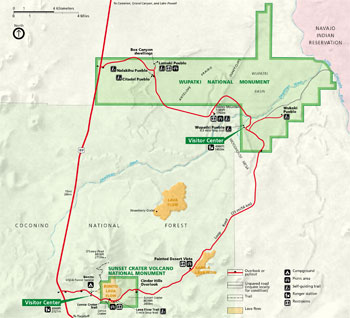 (click for larger map) |
Wupatki National Monument protects the ancient dwellings of puebloan peoples. It occupies 56 square miles of dry, rugged land on the southwestern Colorado Plateau directly west of the Little Colorado River. Sunset Crater Volcano National Monument features a 1,000-foot volcanic cone and its lava flows.
Location, Hours, and Facilities
Sunset Crater Volcano and Wupatki national monuments are reached via U.S. 89.
Their entrances are located 12 miles and 26 miles north of Flagstaff, Ariz. The
parks are connected by a 35-mile loop road. A single entrance fee covers both
parks.
Sunset Crater Volcano Visitor Center, two miles east of the park entrance off U.S. 89, has information, exhibits, and a seismograph station.
Wupatki Visitor Center, 14 miles southeast of the park entrance off U.S. 89, has exhibits and displays of artifacts.
The visitor centers are open daily except December 25; hours vary seasonally. Trails are open daylight hours only. Note: this part of Arizona stays on Mountain Standard Time year-round.
There are no gasoline stations, restaurants, or overnight accommodations in either park. Full services are available in Flagstaff and along U.S. 89. Several picnic areas are located along the loop road. Open fires are allowed only where fire grates are provided. Wood collecting is not permitted.
Camping
The U.S. Forest Service operates Bonito Campground near Sunset Crater. The
facilities include running water and restrooms, but there are no showers or
trailer hookups. The campground is open from late spring through early fall. For
additional camping information contact: Coconino National Forest, Peaks Ranger
Station, 5010 N. Hwy. 89, Flagstaff, AZ 86004; http://www.fs.fed.us/r3/coconino/recreation/pea ks/rec_peaks.shtml
What to See and Do
A driving tour of both parks takes one to two hours. To walk the trails and stop
at the visitor centers, allow three to four hours. At Sunset Crater, the
one-mile Lava Flow Trail at the volcano's base allows you to see a variety of
features. Sunset Crater is closed to climbing to protect its fragile resources.
You may climb other cinder cones in the area, such as nearby Lenox Crater and
Doney Mountain at Wupatki.
Ask at the visitor center for hiking information. A short self-guiding tour of Wupatki Pueblo, the largest dwelling in that monument, begins behind the visitor center. Other sites are also reached by trails: Lomaki Pueblo is a half-mile off the main loop road; Citadel and Nalakihu pueblos are next to the road. A 2½-mile spur road leads to Wukoki Pueblo. All other sites are closed to protect the fragile archeological resources.
For More Information
Walnut Canyon, Wupatki, and Sunset Crater Volcano national monuments are
administered as the Flagstaff Area National Monuments from a headquarters in
Flagstaff, Ariz.
Flagstaff Area National Monuments
6400 N. Highway 89
Flagstaff, AZ 86004
Wupatki National Monument
www.nps.gov/wupa
Sunset Crater Volcano National Monument
www. nps.gov/sucr
Accessibility
Some features in both parks are accessible for visitors with disabilities. Ask
at the visitor centers for more information.
For Your Safety and to Protect the Parks
• All plants, animals, and archeological objects in the parks are protected
by federal laws; there are substantial fines for damage to or removal of these
resources.
• Pets must be kept on a leash at all times; they are not allowed in
buildings or on park trails. Nearby national forest lands offer an alternative
for people traveling with pets; please inquire. The summer heat is intense; pets
left in vehicles—even for a short time—can suffer heat stroke and
die.
• The loop road through the parks is narrow and winding, with soft
shoulders. Stop only at designated pullouts. The speed limits are reduced for
the safety of pedestrians and wildlife. Both parks are at a high elevation and
road surfaces can freeze quickly in winter.
• Stay on the trails to help prevent erosion and to protect the fragile
resources, such as the plants and animals that live here. Off-trail travel is
not permitted in either park. Lava is sharp, brittle, and unstable. A fall on
cinder or lava is not a pleasant experience.
Source: NPS Brochure (2019)
|
Establishment Wupatki National Monument — December 9, 1924 |
For More Information Please Visit The  OFFICIAL NPS WEBSITE |
Documents
A Geologic Field Guide to S P Mountain and its Lava Flow, San Francisco Volcanic Field, Arizona U.S. Geological Survey Open-File Report 2021-1072 (Amber L. Gullikson, M. Elise Rumpf, Lauren A. Edgar, Laszlo P. Keszthelyi, James A. Skinner, Jr. and Lisa Thompson, 2021)
A Survey of Prehistoric Sites in the Region of Flagstaff, Arizona Bureau of American Ethnology Bulletin 104 (Harold S. Colton, 1932)
Acoustical Monitoring 2010: Wupatki National Monument NPS Natural Resource Technical Report NPS/NRSS/NRTR-2013/764 (June 2013)
Anasazi Cultural Parks Study: Assessment of Visitor Experiences at Three Cultural Parks NPS Technical Report NPS/NAUCPRS/NRTR-95/07 (Martha E. Lee and Douglas Stephens, September 1995)
Ancient Southwestern Clothing Conserved (Gwenn Gallenstein, August 31, 2016)
Archeological Assessment of Wupatki National Monument (Dana Hartman and Arthur H. Wolf, February 1977)
Archeological Studies of the Wupatki National Monument (1927)
Arizona Explorer Junior Ranger (Date Unknown; for reference purposes only)
Assessment of Existing Stone Signs: Wupatki National Monument (Debra Frye, April 2006)
Backcountry Management Plan / GMP Amendment / Environmental Assessment, Wupatki National Monument (December 2021)
Bird Community Monitoring for Wupatki National Monument: 2008 Summary Report NPS Natural Resource Data Series NPS/SCPN/NRDS—2012/330 (Jennifer A. Holmes and Matthew J. Johnson, June 2012)
Bird Community Monitoring for Wupatki National Monument: 2011 Summary Report NPS Natural Resource Data Series NPS/SCPN/NRDS—2013/466 (Jennifer A. Holmes and Matthew J. Johnson, April 2013)
Bird Community Monitoring for Wupatki National Monument: 2014 Summary Report NPS Natural Resource Data Series NPS/SCPN/NRDS—2016/1034 (Jennifer A. Holmes and Matthew J. Johnson, June 2016)
Characterization and Correlation of Lava Flows in Wupatki National Monument, Northern Arizona (Sarah L. Hanson, 2006)
Cultural Affiliations of the Flagstaff Area National Monuments: Sunset Crater Volcano, Walnut Canyon, and Wupatki Final Report (Rebecca S. Toupal and Heather Fauland, September 26, 2007)
Distribution and habitat associations of the Little Striped Whiptail (Cnemidophorus inornatus) at Wupatki National Monument, Arizona USGS Open-File Report 2005-1139 (Trevor B. Persons, 2005)
Draft Wilderness Study / Environmental Assessment: Wupatki National Monument, Arizona (October 2024)
Evaluation of Gully Erosion for Archaeological Preservation in Wupatki National Monument NPS Natural Resource Report NPS/WUPA/NRR-2024/2630 (Celeste Wieting, Sara Rathburn and John Kemper, February 2024)
Excavation of the Wupatki Blowhole Site, NA7824 Memorandum RM-3139-RC (R.A. Schley, November 1962)
Excavations in Big Hawk Valley, Wupatki National Monument, Arizona Museum of Northern Arizona Bulletin 24 (Watson Smith, 1952, ©Museum of Northern Arizona)
Final Environmental Impact Statement/General Management Plan, Wupatki National Monument, Arizona (November 2002)
Foundation Document, Wupatki National Monument, Arizona (May 2015)
Foundation Document Overview, Wupatki National Monument, Arizona (January 2015)
General Management/Development Concept Plan, Wupatki and Sunset Crater National Monuments, Arizona (June 1982)
Geologic Map of Wupatki National Monument and Vicinity, Coconino County, Northern Arizona USGS Scientific Investigations Map 2958 (George H. Billingsley, Susan S. Priest and Tracey J. Felger, 2007)
Geologic Resources Inventory Report, Wupatki National Monument NPS Natural Resource Report NPS/NRPC/GRD/NRR-2011/416 (J. Graham, June 2011)
Ground Water in the Wupatki and Sunset Crater National Monuments, Coconino County, Arizona USGS Geological Survey Water-Supply Paper 1475-J (Oliver J. Cosner, 1962)
Integrated Upland Vegetation and Soils Monitoring for Wupatki National Monument: 2007 Summary Report NPS Natural Resource Data Series NPS/SCPN/NRDS—2009/006 (James K. DeCoster and Megan C. Swan, July 2009)
Integrated Upland Vegetation and Soils Monitoring for Wupatki National Monument: 2008 Summary Report NPS Natural Resource Data Series NPS/SCPN/NRDS—2009/022 (James K. DeCoster and Megan C. Swan, December 2009)
Integrated Upland Vegetation and Soils Monitoring for Wupatki National Monument: 2010 Summary Report NPS Natural Resource Data Series NPS/SCPN/NRDS—2013/515 (James K. DeCoster and Megan C. Swan, July 2013)
Integrated Upland Vegetation and Soils Monitoring for Wupatki National Monument: 2012–2014 Summary Report NPS Natural Resource Data Series NPS/WUPA/NRDS-2016/1039 (James K. DeCoster and Megan C. Swan, August 2016)
Interpretive Prospectus, Sunset Crater National Monument and Wupatki National Monument, Arizona (December 1983)
Interpretive Prospectus: Wupatki National Monument, Arizona (1995)
Inventory of Mammals at Walnut Canyon, Wupatki, and Sunset Crater National Monuments NPS Natural Resource Technical Report NPS/SCPN/NRTR-2009/278 (Charles Drost, December 2009)
Investigations of Small Structures in the Citadel District of Wupatki National Monument: Report of Test Excavations at Eight Small Sites, June 2000 - December 2001 (Ruth E. Lambert, September 30, 2002)
Junior Arizona Archeologist (2016; for reference purposes only)
Junior Ranger Workbook, Wupatki National Monument (Date Unknown; for reference purposes only)
Meteorological-Geological Investigations of the Wupatki Blowhole System Memorandum RM-3139-RC (J.D. Sartor and D.L. Lamar, June 1962)
National Register of Historic Places Nomination Form
Wupatki National Monument (Catherine M. Cameron and Cherie J. Scheick, July 28, 1992)
Natural Resource Condition Assessment, Wupatki National Monument NPS Natural Resource Report NPS/SCPN/NRR-2018/1613 (Lisa Baril, Patricia Valentine-Darby, Kimberly Struthers, Paul Whitefield, William H. Romme and Kirk Anderson, March 2018)
Natural Resource Survey and Analysis of Sunset Crater and Wupatki National Monuments Final Report (Gary C. Bateman, December 1976; incomplete)
Natural Resource Survey and Analysis of Sunset Crater and Wupatki National Monuments Final Report (Phase III) (Gary C. Bateman, January 1980; incomplete)
Natural Resource Survey and Analysis of Sunset Crater and Wupatki National Monuments Final Report (Phase IV) (Gary C. Bateman, January 1981; incomplete)
Nalakihu: Excavations at a Pueblo III Site on Wupatki National Monument, Arizona Museum of Northern Arizona Bulletin 23 (Dale S. King, 1949; ©Museum of Northern Arizona)
Park Newspaper (InterPARK Messenger): c1990s • 1992
Park Newspaper (Ancient Times): 1998-1999 • 2000-2001 • 2003 • 2004 • 2006-2007 • 2007-2008 • 2016 • 2017
Roadside Geology: Wupatki and Sunset Crater Volcano National Monuments Arizona Geological Survey Down-To-Earth 15 (Sarah L. Hanson, 2003; ©Arizona Geological Survey)
Seed Plants of Wupatki and Sunset Crater National Monuments Museum of Northern Arizona Bulletin 37 (W.B. McDougall, 1962, ©Museum of Northern Arizona, Archives, all rights reserved)
Soil Survey and Range Site and Condition Inventory: Wupatki National Monument, Arizona — A Special Report (January 1971)
Soil Survey of Wupatki National Monument, Arizona (2015)
The Excavation of Room 7: Wupatki (HTML edition) Southwestern Monuments Special Report No. 13 (Eric K. Reed and J.W. Brewer, Jr., January 1937)
The Navajo Country — A Geographic and Hydrographic Reconnaissance of Parts of Arizona, New Mexico and Utah USGS Water Supply Paper 380 (Herbert E. Gregory, 1916)
The Origin of Cinders in Wupatki National Monument: Lay Report (Jason A. Hooten, Michael H. Ort and Mark D. Elson, abstract from The Origin of Cinders in Wupatki National Monument, 2001)
The Road Inventory for the Flagstaff Area Parks: Sunset Crater Volcano, Wupatki, and Walnut Canyon National Monuments (Federal Highway Administration, April 1999 )
The Wupatki Archeological Inventory Survey Project: Final Report Southwest Cultural Resources Center (SCRC) Professional Papers No. 35 (Bruce A. Anderson, 1990)
Traditional Resource Use of the Flagstaff Area Monuments Final Report (Rebecca S. Toupal and Richard W. Stoffle, July 19, 2004)
Water-quality data for Walnut Canyon and Wupatki National Monuments, Arizona, 2001-02 USGS Open-File Report 2003-286 (Blakemore E. Thomas, 2003)
Wupatki National Monument Volcanic Upland 2020 Data Summary NPS Natural Resource Data Series NPS/SCPN/NRDS-2022/1359 (Megan Swan and Carrie Veety, June 2022)
wupa/index.htm
Last Updated: 01-Jan-2025