|
YELLOWSTONE
Trailside Notes (Number One) |

|
TRAILSIDE NOTES
III. Madison Junction to Old Faithful
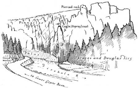
Having visited the museum and enjoyed the view down the Madison Valley we set our mileage at zero, cross the concrete bridge and enter the Firehole River Gorge. We will drive slowly for the next two miles and observe the striking exposures of volcanic rock: Pinkish rhyolite, soft gray pumice, black, glassy obsidian, red and black perlite with glassy bubbles and breccia of cemented rock fragments, all interspersed with white, soft tuff. A magnificent wall of rock carved into pinnacles, rises before us. Alcoves in the wall result from the ease with which the perlite becomes weathered.
NOTE: The text is arranged in three columns. Objects on the tourists' right are described on the right-hand side of the page; those on the tourists' left, on the left-hand side. Objects in front and general descriptions occupy the middle of the page.
Due to changes in the road, distances as given are only approximately correct. Government markers by the roadside give more exact distances.
Web Edition Note: Due to numerous changes in the years since this guidebook was published, the text should solely be used for historical purposes.
| MILEAGE | MILEAGE | |||||
| 0.3 |
How different is the grim mass of volcanic rock on
the right from the exposure of rhyolite on the left! Can it be that we
are looking at the face or side of what was once a glowing, viscous mass
of molten rocks accompanied by intense heat and roaring with the
crackling and crushing of its crust. It was a diabolical river of fire,
slowly flowing from some unknown source. |
0.3 | ||||
 | ||||||
|
0.5 We stop where a little stream trickles down over the rocks. Flowers abound. We dismount, identify the flowers, look up on the opposite side and discover an osprey's nest. | ||||||
 | ||||||
|
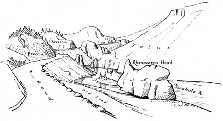
FIREHOLE CANYON FIELD EXHIBIT The artificial cutting of the road gives us a rare opportunity actually to look into the very substance of a congealed flow of lava. The angular fragments show that there must have been volcanic explosions of great violence and of long duration. This was not a silent performance. It was no place for tourists. Note the large boulders and angular fragments imbedded in the lava and volcanic ash. Those boulders of obsidian prove that there were old rhyolitic flows long before the expulsion of this mass of volcanic rubbish. | ||||||
 | ||||||
| 1.5 | As we proceed, note again how the river has undercut the cliffs and made a series of caves along a line horizontal with its present level. It must have been flowing at about where it is a long time but cavities above the stream prove that it once flowed at a higher level. How different is the craftsmanship of cold water flowing over the surface of igneous rocks from that of hot water flowing out from them. | 1.5 | ||||
| 1.9 |
A little fertile valley—grass bordered. This is evidence that for a time there was a dam holding the water back and thus producing a small lake or pond. Lodgepole pines do not need very much soil. Note those growing on isolated boulders. |
1.9 | ||||
 | ||||||
| Look back. Observe Purple Mountain. We are nearing the top of these lava flows. | ||||||
| ||||||
| ||||||
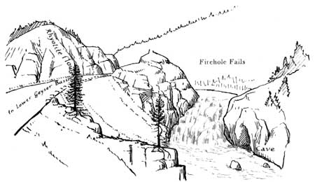
| 5.7 |
THE LOWER GEYSER BASIN Having climbed the Firehole we are now again at about the same level as when we were at Swan Lake Flat and at the Gibbon Meadows. |
5.7 | ||||
| ||||||
|
The Lower Geyser Basin opens out before us. This is the largest geyser basin in the park. The Hayden Survey counted 680 geysers and hot springs in this basin. | ||||||
| ||||||
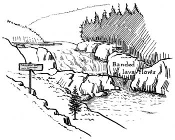
| Before seeing the sights, however, let us orient ourselves. Looking back we pick up our old landmark, Mount Holmes. The skyline at the left is the crest of Purple Mountain. To the west lie the small Twin Buttes. Observe the wide area covered by sinter. Consider the time necessary for its deposition. Think of the depth of the travertine at Mammoth. But this is not lime extracted from sedimentary rocks. It is silica extracted from volcanic rocks. | ||||||
| 8.1 At the left a road branches to Firehole Lake, Steady and Great Fountain Geysers. Those taking this road will re-enter the main highway a mile to the south. There are several outstanding exhibits. | ||||||
| We enter a Lodgepole forest and continue south. | ||||||
| 8.3 On the left, a quarter of a mile away, we see the cone of White Dome and the steam rising from Firehole Lake. We may wish that we had taken the branch road. | ||||||
| 9.1 We meet the road which returns from Firehole Lake, etc. | ||||||
| 9.6 |
LODGEPOLES We continue to the south and presently come again to the Firehole River. Directly opposite is where Excelsior Geyser once threw up an amazing mass of water to a height of 300 feet, hurling rocks and sinter to a great distance. The story of Excelsior is one of historic interest. |
9.6 | ||||
|
Parking area for Midway Geyser Basin. Dismount and read the story of Excelsior. Note the Grand Prismatic Spring. Before leaving, glance up to the east and note that the old masses of lava are still with us. The scars on distant hills are evidence of its marvelous thickness. The river is growing smaller. |
10.3 | |||||
| ||||||
|
UPPER GEYSER BASIN The Ranger Naturalists at Old Faithful conduct parties to all places of interest in this the Upper Geyser Basin. | ||||||
| ||||||
| ||||||
| ||||||
| 14.8 |
Cross the Bridge noting Riverside Geyser on the left. This geyser plays three times daily at regular intervals. We are about to witness the most famous display of geyser activity in the world. |
14.8 | ||||
|
14.9 Grotto Geyser has a fantastically shaped cone unlike any other in the park. | ||||||
| 15 Giant Geyser, the broken cone on your left. Inquire about it at the museum. | ||||||
| 15.6 | We pass Castle Geyser, with its characteristic cone, sweep in front of the famous Inn and come to rest at the parking space, adjoining the Old Faithful Trailside Museum. Here we find a bureau of information, an accommodating staff of ranger naturalists, and an outdoor auditorium where lectures appropriate to Yellowstone are given to the public without charge. | 15.6 | ||||
| <<< Previous | Next >>> |
trailside_notes/sec3-1.htm
Last Updated: 02-Apr-2007