|
COLONIAL
Yorktown's Main Street Historic Resource Study |

|
ILLUSTRATIONS
|
|
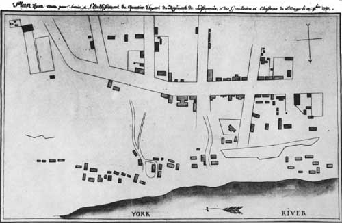
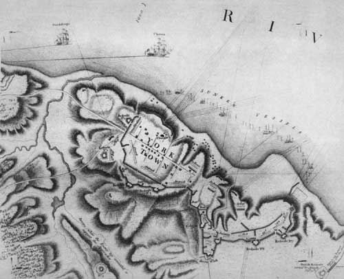
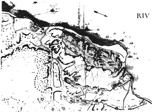
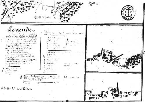
No. 1 The Berthier billeting plan of Yorktown,
1781. "Plan d'york town pour Servier a l'Establissement du d'hyner du Regiment de Soissonnois et des Grenadiers et Chasseurs de St. Onge le 12 8 bre 1781." From the Alexandre Berthier Papers in the Princeton University library. (16,588) (click on image for a PDF version) |
|
|
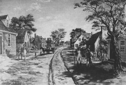
No. 2 Main Street eastward from Church Street just prior to the siege
of 1781. The Somerwell House is shown in part on the extreme left. A 1957 interpretive painting done for on-site exhibit by Sidney E. King of Caroline County, Va. From Thomas L. Williams, Williamsburg, Va. |
|
|
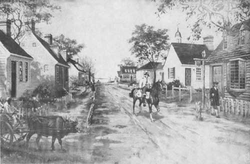
No. 3 Main Street westward from Church Street just prior to the siege
of 1781. Note windmill at far end of street overlooking the river. A 1957 interpretive painting done for on-site exhibit by Sidney E. King of Caroline County, Va. From Thomas L. Williams, Williamsburg, Va. |
|
|
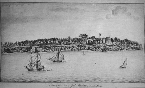
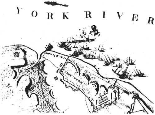
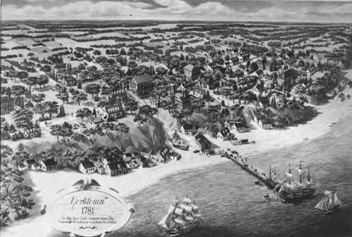
No. 4 Yorktown as viewed from the river in 1755 (sketched by John Gauntlett
aboard the HMS Norwich anchored in the Yorktown Harbor). It shows the full length of the town from the windmill off the northeast end of town to, and a little beyond, the Secretary Thomas Nelson House to the southeast. A bit left of center is the presently existing Nelson House and the second courthouse is directly behind the flagpole. From the manuscript volume, "Voyage of H.M.S. Success and H.M.S. Norwich to Nova Scotia and Virginia 1754-1756," in the Mariners Museum, Newport News, Va.; also published in the Virginia Magazine of History and Biography, 54 (1946), pp. 99-105. (13,111) |
|
|
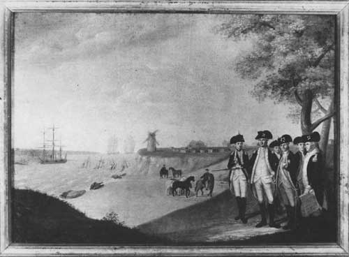
No. 5 James Peale's painting of the "Meeting of the Generals of Yorktown"
with the windmill in the background across Yorktown Creek. Courtesy of the Colonial Williamsburg Foundation (Williamsburg, Va.); this is amore precisely executed copy of the same painting in the collection of the Maryland Historical Society, Baltimore, Maryland. |
|
|
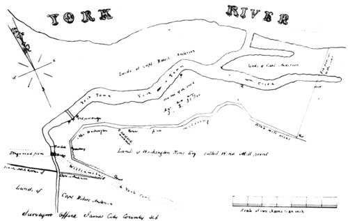
No. 6A An 1850 land plat showing the old windmill site and the meanderings
of the mouth of Yorktown Creek. From a copy of the plat in the files of Colonial NHP. (8,561) (click on image for a PDF version) |
|
|
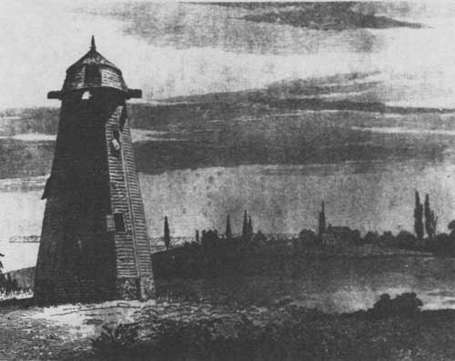
No. 6B The old windmill tower at Yorktown much in disrepair prior to 1840. From The Family Magazine (New York edition), 7 (1840), 221. (12,900) |
|
|
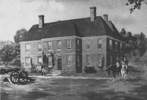
No. 7 The Secretary Thomas Nelson mansion. The siege opened with British headquarters in this building. An interpretive painting done about 1957 for on-site exhibit by Sidney E. King of Caroline County, Va. (13,128) |
|
|
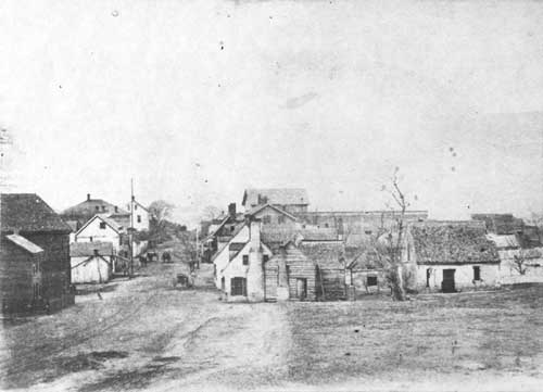
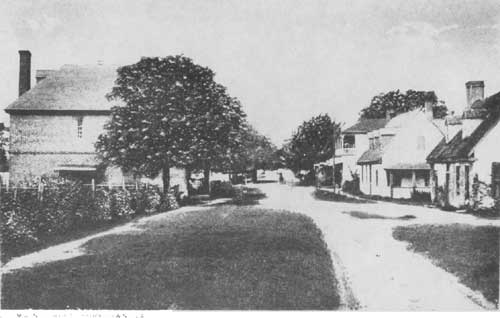
No. 8 A revealing early photograph of Main Street in the late 1870's. The old brick storehouse ("customhouse") of Richard Ambler is in the left foreground, and the Cox House, with dependencies behind it, is across the street in the immediate right foreground. This photograph obviously was that used for the sketch of Main Street prepared for Steven's Yorktown Centennial Handbook issued in 1881 (p. 105). See park photograph No. 10,913. This view is a 1958 photocopy of an item in the collection of the late Mrs. Katherine Blow. (13,253) |
|
|
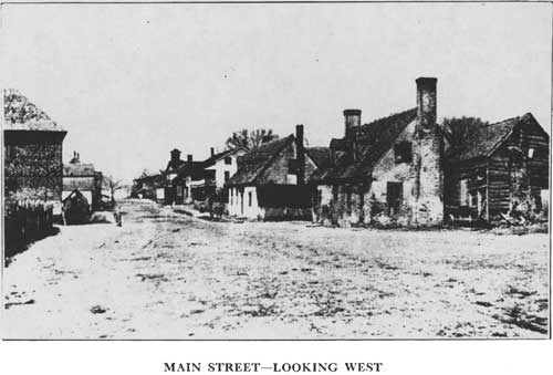
No. 9 Main Street in the 1880's. This is westward from the Church Street crossing of Main. The three larger structures would be on Lots 31 (Bar Room), 25 (Brent's Tavern), and 19 (a residence). From Harry R. Houston, The Peninsula of Virgina (1934), by courtesy of John Mitchell, Director of Syms Eaton Museum, Hampton, Va. (16,744 - a similar view, but dated 1886, from Robert Arthur, The Two Sieges of Yorktwon, Fort Monroe, Va., 1927). |
|
|
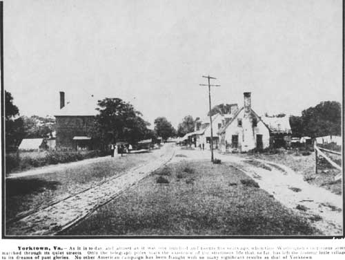
No. 10 Main Street about 1900. The view is westward from a pont east beyond Read Stree. From Mrs. Sydney Smith, Old Yorktown and Its History, c. 1920. (14,142) |

|
|
No. 11 Main Street about 1903. The view is westward from a point east of Nelson Streeet. The Sessions House and then the Nelson House show on the left. Photocopy of an old postal card copyrighted in 1903. (16,749) |
|
|
No. 12 Main Street about 1905. This is westward from a point east of Read Street. From a Jamestown Exposition Peninsula guidebook. |
|
|
No. 13 Main Street about 1907. The view is westward from a point closer to Read Street than Illustration No. 12. From an old postal card; photograph from Thomas L. Williams, Williamsburg, Va. |
|
|
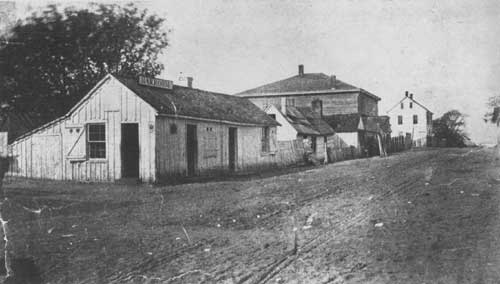
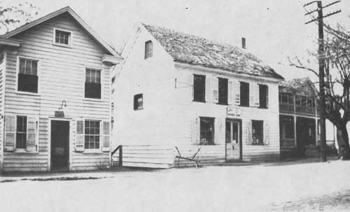
No. 14 The Burcher Spinning Wheel Antique Shop in
1931. This white two-story shop is flanked by two late structures on Lot 37 that no longer stand. (2,346) |
|
|
No. 15 The Hills (British) siege plan. A section from "A Plan of York Town and Gloucester, Shewing the Works constructed for the Defense of those Posts by the British Army . . . from an actual Survey in the Possession of Jno Hills late Lieut in the 23d Regt & Asst Engr. From a copy of the plan engraved and printed for William Faden, London, October 7, 1785. (16,738) (click on image for a PDF version) |
|
|
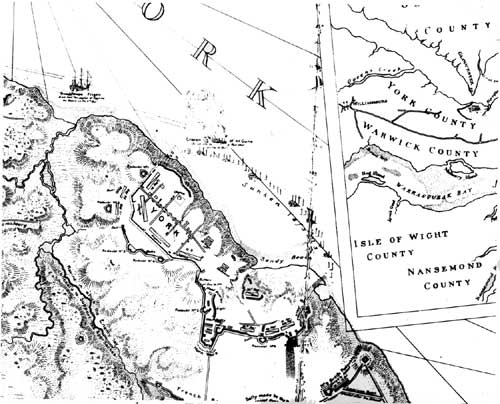
No. 16 The Fage (British) siege plan. This is a section from "A Plan of the Post of York and Gloucester in the Province of Virginia, Established by His Majesty's Army under the Command of Lieut. Earl Cornwallis together with the Attacks and Operations of the American & French Forces . . . Surveyd by Capt. Fage of the Royal Artillery. Published according to Act of Parliament the 4th June 1782." From a reproduced copy of the plan, a copy of which is in the Colonial NHP library. (16,745) (click on image for a PDF version) |
|
|
No. 17 The Hayman (British) siege plan. This is a section of a "Plan of the Siege of Yorktown," a manuscript map dated June 12, 1782, and signed by John Hayman "Lieut. 17th Infy." From a photostatic copy in the Colonial NHP library. (9,858) (click on image for a PDF version) |
|
|
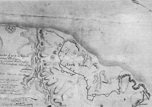
No. 18 The Bauman (American) siege plan. A section of Maj. Sebastian Bauman's "Plan of the investment of York and Gloucester . . . taken between 22d and the 28th of Oct. 1781." From a photostatic copy of the map as engraved and printed in Philadelphia in 1782. (9,862) (click on image for a PDF version) |
|
|
No. 19 The Gouvion (American) siege plan. A section from the "Plan of Attaques of York in Virginia . . ." by Lt. Col. of Engineers Gouvion and dated "before york," October 29, 1781. From a copy of the plan as published by the National Archives (Facsimile No. 21) under the title "Washington's Official Map of Yorktown," Washington, 1952. (16,737) (click on image for a PDF version) |
|
|
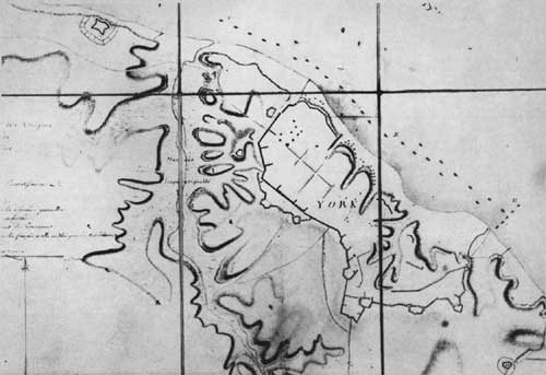
No. 20 The La Combe (French) siege plan. A section from Querenet de La Combe's "Plan d'York en Virginie avec les attaques faites par les armees Francoise et Americaine en 8 bre 1781." A manuscript map in the Map Division, Library of Congress, photostat in Colonial NHP library. (9,859) (click on image for a PDF version) |
|
|
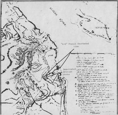
No. 21 How the French shortened the British line — another siege plan. A section from "Plan du Siege d'york fait par l'armee Combinee d'Amerique et de france sous les ordres du General Washington: le place fut investie le 27 7 bre 1781." From a photostatic copy in the files of Colonial NHP — made available by the French Archives in 1973. (16,754) (click on image for a PDF version) |
|
|
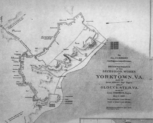
No. 22 A plan of the Confederate line built around Yorktown. From the Atlas to Accompany the Official Records of the Union and Confederate Armies (Washington, 1891-1895), plate 16, part 1. (16,671) (click on image for a PDF version) |
|
|
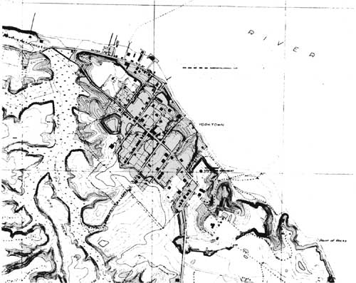
No. 23 Yorktown area detail from the east street of the 1931 U.S.
Geological Survey. The Civil War works can be traced in the topography, especially when this plan is compared to the details in Illustration No. 22. (16,746) (click on image for a PDF version) |
|
|
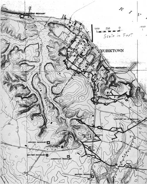
No. 24 Secton from a special 1931 battlefield topographical map done by
the U.S. Geological Survey. The British line of 1781 has been overlaid and the conformity of the Civil War works, or the lack of it at several points, can be seen from the topography of these works. See also Illustration Nos. 22 and 23. (16,747) (click on image for a PDF version) |
|
|
No. 25 Cross section of two types of British works at Yorktown from a
French siege plan. "Plan du Siege d'York, en Virginie par l'Armee alliee d'Amerique et de france Sous les Ordres des Gaux Washington et Cte de Rochambeau: contre l'Armee Anglaise Commandee par Lord Cornwallis en Octobre 1781," photostat in Colonial NHP library. (7,312) |
|
|
No. 26 Yorktown before the damage of the siege in
1781. A reflection on the nature of colonial Yorktown. It does not (because of the limited scope of surviving records) purport to be a full picture of all physical development and then visible aspects of the town. Main Street runs diagonally through the view from the Windmill (upper right corner) to the Secretary Thomas Nelson Home (just up from center in the left margin). An interpretive painting for Yorktown Visitor Center use done by the Branch of Museums in 1956. (12,899) |
|
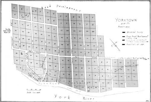
| Plan: "Yorktown and Its Additions," (with street names and lot numbers) (click on image for a PDF version) |
| <<< Previous | <<< Contents>>> |
yorktowns-main-street/illustrations.htm
Last Updated: 22-Jan-2010