|
Capitol Reef
Administrative History |

|
CHAPTER 11:
FROM MONUMENT TO
PARK, 1969 TO 1971 (continued)
Financial, Staffing And Management
Concerns
Before the hearings could be convened, however, Rep. Wayne Aspinall made good his threat to President Johnson by denying funding to any of the newly expanded monument lands. As chairman of the House Interior Committee, Aspinall had significant influence over the entire National Park Service budget. He based his decision on the principle that
Congress had not been consulted before the presidential proclamations were signed. It is interesting to note that while he refused to authorize spending for the new monuments, Aspenall was encouraging full funding of national recreation areas and expanding agency "manpower to cope with crime, crowds, and cars." [32]
It is unclear what lasting effect Aspinall's decision had on Capitol Reef, but the fact that the monument had been expanded by six times while at less than full staffing for its original size had park management worried. Even before the monument was expanded, financial constraints were felt at Capitol Reef. Superintendent Heyder had to lapse the protection ranger and maintenance foreman positions due to a reduced budget during the 1969 fiscal year. The public felt this financial pinch when the monument was forced to close the campground for the winter and reduce visitor center operations to only five days a week. [33]
Then in early March 1969, as the expansion controversy was at its peak, there was a major restructuring of the southern Utah parks and monuments. The plan called for a Southern Utah Group headquarters at Cedar City to serve as a mini-regional office for Zion and Bryce Canyon National Parks and Capitol Reef, Cedar Breaks, and Pipe Springs National Monuments. This cluster idea was designed to enable general administrative, management, and planning activities to be coordinated within one central office, thereby reducing the workload and the need for staff increases at the park level. To accomplish these goals, the Zion National Park superintendent became group superintendent; so Superintendent Oscar Dick moved to Zion from Bryce Canyon. Robert Heyder was chosen to replace Dick at Bryce Canyon, and Chief Ranger Bert Speed served as acting superintendent for Capitol Reef until a new superintendent was appointed. [34]
While this plan may have been a worthy attempt to increase efficiency, the fiscal restraints and personnel shifts could not have come at a worse time for Capitol Reef. Besides the financial and staffing hardships, the most significant damage caused by this reorganization was removing Heyder from Capitol Reef just when continuity was crucial.
As it turned out, the new superintendent for Capitol Reef, William Franklin Wallace, played a small role in the monument to park process, leaving Bert Speed to take care of virtually all the correspondence, planning, and congressional testimony.
The Southern Utah Group itself proved short-lived. In August 1972, the cluster concept was abandoned and the parks and monuments returned to their old organizational structure--with one difference. Capitol Reef was, by then, a national park. [35]
Congressional Hearings: May
1969
The U. S. Senate Parks and Recreation Subcommittee, chaired by Sen. Alan Bible of Nevada, began its Utah hearings in Salt Lake City on May 15, 1969. In his introductory remarks, Sen. Moss pointed out that he had not approved of President Johnson's method of adding National Park Service lands in Utah, since it had not involved public hearings and congressional debate. Moss was, however, impressed by the new monument lands and favored creating national parks out of the monuments with only slight alterations. [36]
Moss' proposed changes would reduce the total acreage of Capitol Reef from the 254,242-acre monument to a 242,257-acre national park. As mentioned above, the areas added to the boundaries included the Halls Creek Narrows in the south, and Cathedral Valley, Temples of the Moon and Sun, upper Deep Creek, and Paradise Flat in the northern district. Since some grazing would still remain within the newly proposed park, Moss provided amendments that would protect the permittees, proposing:
[G]razing permits held at the time the acts establishing the Arches and Capitol Reef National Parks are signed, may be continued and renewed during the lifetime of the holder and the lifetime of his immediate heirs. This is, incidentally, the same provision which was contained in my original Canyonlands National Park Bill. It was accepted in essence in the version of the bill which the Senate passed but was modified in the House. [37]
Moss believed that a few cows would add charm to the scenery, whereas large herds would be a problem. The senator felt that compromises could be reached to "realize the most out of the spectacular scenery and unusual scientific phenomenon which these two areas afford, and at the same time protect the rights of those who have a different economic stake in the regions." [38]
Moss also pointed out that with the construction of Interstate Highway 70, to be completed just north of Arches and Capitol Reef by 1972, millions of tourists would be on their way to enjoy the scenic potential of five national parks--more than any other state at that time. Increased tourism, scenic protection, and continued resource development were Moss' reasons for sponsoring his national park bills. He realized some would perceive him and fellow Utahns as "having [their] cake here in Utah and eat[ing] it too," but felt that appropriate compromises were attainable. Others testifying at the hearings were also willing to compromise--as long as their perspective carried the most weight.
The Salt Lake hearings were by far the most balanced. Of the 25 written statements included in the record, 13 opposed the Capitol Reef expansion, two were willing to accept the new boundaries so long as multiple-use privileges continued, and seven favored the Moss park bill. The National Park Service did not testify at these hearings. [39]
Don Pace, who had earlier represented the 41 families who believed their ranches would be lost to expansion, arrived with statistics to back his claims of hardship. According to Pace's figures, the 41 affected families would lose 5,331 AUMs, which would result in calf sale losses of up to $40,000 and would force the families to either go on social security or sell out and move away. Pace believed the entire economy of Wayne County would be adversely affected by the new park, testifying:
The economy of Wayne County, as are many of the counties in southern Utah, is greatly dependent on public lands. Eighty-eight percent of the land in the county is federally owned and administered. Most other counties in this region are in a similar position, with an average of about 75 percent of the land being federally owned. Any placing of large tracts of this land in single use will have serious effects on the already depressed economy in the area. Placing the land under single use, such as National Parks, terminates all oil and gas development, and all grazing rights are terminated, all mining operations stop, watershed and soil conservation stops, logging and lumbering stop, all hunting and fishing stops, and much of the tax base of the area stops. [40]
Vocalizing the feeling of many neighbors of Capitol Reef, Pace summarized:
I feel there is a great need for more local say, influence and control over factors of vital social and economic impact in the nation. Those who live in this area I know are a small minority, but we resent very much being controlled by politicians in Washington and special interest groups in other parts of the nation. Most of these people will never see our area and what few do will see it only on a passing through short visit basis, yet, they determine our livelihoods and the future course of our very existence. [41]
Pace was also concerned that the increase in monument acreage by six times could not be adequately developed for increased tourism since "even now the park service is not able to adequately care for and keep open all year the 39,000 acres included in the old National Monument." He wanted the roads and rights-of-way developed and feared that the National Park Service would be unable or unwilling to do so. In short, Pace supported Sen. Bennett's bill to create a national park from the old monument boundaries. This would make a more alluring tourist attraction while insuring that traditional land use would continue to the north and south. [42]
While rancher Pace provided an excellent example of the local opposition to the monument expansion and Moss' park bill, others testified that the multiple-use value of the land in question was vastly over-estimated. Wilda Gene Hatch, president of the expansion-supportive Ogden Standard-Examiner, agreed that hardships would occur if the grazing permits were immediately terminated. However, she wrote:
[I]t would be easy for the grazing land to be withdrawn over a period of at least 20 years. This 'staged phase-out' would permit the livestock owners to find replacement range on other lands. Over the long haul, the economic return to the country and state--and to the people involved--would be greater, we are confident, from spending of tourists than from the present, marginal livestock operations. [43]
As to the mineral potential, Hatch quoted from her paper's editorial of May 13:
[T]here are no proven reserves there of scarce minerals and the return from exploitation of the mineral resources is far more speculative than is the potential. There is no shortage in [other areas of] Utah of potash, oil, bituminous sand, oil shale, gas and uranium--the major minerals concerned. [44]
Like other supporters of S.531, Hatch believed that the loss of minimal grazing and mineral potential was far outweighed by the benefits of scenery protection and potential tourist developments. Hatch, who had attended the conservationists' meeting with Moss back in February, believed that tourist dollars would soon replace the lost ranching incomes in the affected areas.
As the hearings headed south to Richfield and then over to Moab, the testimony was similar but (as expected) heavily weighted in opposition to an expanded Capitol Reef and Arches National Parks. The testimony at all these hearings clarified the objectives of those in favor of and opposed to Moss' bill, without the hysteria that had greeted the initial proclamation news. By this time, it was clear that there would have to be some compromise of scenic, natural resources to insure grazing and mining privileges for at least several years. Supporters showed their willingness to compromise by supporting Moss' bill and amendments. Those in opposition, though, were still hoping that another, more favorable alternative could be found. When Republican Rep. Lawrence Burton arrived with his subcommittee to hold hearings in Escalante at the end of May 1969, those resisting monument/park expansion renewed their effort.
Burton invited Rep. Walter Baring of Nevada to bring his Subcommittee On Public Lands of the Committee on Interior and Insular Affairs to Escalante, to hear "testimony on the withdrawals of public lands by presidential proclamation for the expansion of Capitol Reef National Monument." Hearings on Arches National Monument had been conducted earlier. In addition to Baring and Burton (who was not a member of the subcommittee), Republican Rep. Don Clausen was invited to attend the hearings. Clausen, of northern California, had recently gone through his own national park debates over the newly created Redwood National Park. [45]
Robert Heyder, by this time superintendent at Bryce Canyon, was the National Park Service representative. He began the meeting by outlining the new monument boundaries. Then Clausen asked Heyder if any hearings were held or people informally contacted before the proclamation. Heyder answered that he did not know of any. [46]
Most of the testimony was similar to that at the Moss hearing, with many of the same speakers present. Garfield County Commissioner Dale Marsh spoke for the opposition:
Now, we are not opposed to national parks or monuments as such, but we would like the Government to make an economic analysis of each area as to its best use. In this way the public interests are best served. Park boundaries should be pushed back for the economical potential of the areas that are not affected. The recent monument extensions reduce the area for building our own state. This land now becomes a reserve desert or a mountain range that we can not use. [47]
One neighbor of Capitol Reef, Lurton Knee, favored the enlargement. Knee's Sleeping Rainbow Guest Ranch was one of the few tourist-oriented businesses in the area. Knee's property was also now within the new monument boundaries. Clearly, he had much to gain--or lose--with the resolution of this debate. He seemed to like Sen. Moss' bill, testifying:
We are strongly in favor of the enlargement--I should say, of modest enlargement--with the necessary adjustments for the cattlemen who need the portions of their grazing lands within the new boundary for winter feed. We feel this could be arranged for, as there is already a modified multiple-use in Capitol Reef National Monument by allowing the stock drives through the monument in the spring and fall. [48]
Knee also cautioned against any attempt to make a national park within the old monument boundaries:
We are strongly against withdrawing the new boundaries to the original 61 square miles and then attempting to make it into a national park, when there would be no necessity in trying to give such a small area 'park status,' when it could still be administered as a national monument and in turn the counties will lose the extra revenue which would be theirs if Capitol Reef is enlarged enough to become a national park. The other areas inside the new boundary are needed, not only for beauty, geologic interest, but for protection, especially lower Cathedral Valley and the unique selenite plug [Glass Mountain], as well as the magnificently awe-inspiring southern ramparts of the great Waterpocket Fold. [49]
A proponent of a modified expansion was George Hatch, president of KUTV in Salt Lake City and husband of Wilda Gene Hatch of the Ogden Standard-Examiner. Like Knee, Hatch believed multiple-use could be accommodated while also protecting the natural resources. The best way to do this, argued Hatch, was to adjust the boundaries from section lines to natural contours. This would allow grazing and oil and gas exploration in the not-so-spectacular flatlands to the east and in the Circle Cliff plateaus to the west. Hatch proposed a multiple-use national recreation area buffer zone to be created out of deleted portions east and west of the Waterpocket Fold. He also echoed Knee on the need to improve the monument in such a way that would protect natural beauty and increase the likelihood that it could be considered for national park status, arguing:
The monument can be substantially improved by adding scenic and scientific areas that have been overlooked in the present enlargement and grazing and mining can be accommodated by deleting many of the less important areas that have been included in the present enlargement and by placing substantial parts of the enlargement in a Capitol Reef National Recreation Area buffer zone in which grazing and mining exploration would be permanently permitted. Anyone who will take the time to walk through the deep canyons and spectacular formations of the Water-Pocket Fold will agree that it is well worth the time and effort to survey and draw proper boundaries for the benefit of many future generations. [50]
The opinions of Hatch and Knee aside, the vast majority of those speaking at the Escalante hearing on May 31 were ranchers, miners, and politicians opposed to the initial presidential proclamation. They did not contest a change to national park status, just so long as their traditional multiple-use lands retained that status.
The local hearings that the Utah congressional delegation had demanded back in January were now over. The focus shifted back to Washington politics as Moss, Bennett, and Burton tried to get some kind of legislation passed concerning Capitol Reef and Arches. Meanwhile, the National Park Service began to formalize its boundary alternatives and management objectives.
The National Park Service Makes A
Decision
Investigative field work began in March 1969, when Heyder, Bates Wilson, Acting Superintendent Speed, and several others made a three-day reconnaissance of the monument additions. Upon their return, Heyder developed management objectives for a very different Capitol Reef National Monument. [51]
The management objectives document, dated March 1969, stated that the purpose of the additions was to
preserve an area containing 'narrow canyons displaying evidence of ancient sand dune deposits of unusual scientific value' (50 Stat. 1856) and a world-famous monoclinal flexure–the Waterpocket Fold–which extends breathtaking scenery of stratigraphy and erosion for some 60 miles–connecting the high plateaus with the red rock rims of Lake Powell. [52]
The document continued, "The area is scenically unique, geologically significant, and biologically interesting. It offers visitors an unexcelled opportunity for exciting involvement in a fascinating wild area, ideally suited to investigation on foot."
Existing commitments listed included the stock driveway rights-of-way and special permits included in the old monument. There are no permits listed within the new additions. The major resources listed were, in order, geology, vegetative communities of which there were "numerous small niches hold[ing] endemic plant communities which are unique," and numerous historical and archeological sites "which [would] be managed under the administrative policies for historical areas."
The roads mentioned included Utah Highway 24 along the Fremont River, and the Burr Trail, which if paved would "change the traffic patterns of visitation" for all of southern Utah. The document recommended that National Park Service managers closely attend to the master plans of adjacent USFS and BLM lands. As for the local communities, Heyder described a growing investment of capital toward a tourist industry, but noted that it still had a long way to go. [53]
Heyder recommended that studies be made to determine "the carrying capacity of the several environments," since much of the area was fragile, desert landscape. Camping should be restricted to the main headquarters campground, with only small, primitive campgrounds at outlying areas. While hiking should be encouraged ("It is a hiker's park"), four-wheel drive use was appropriate along marked routes such as the Halls Creek, Oak Creek, and Pleasant Creek drainages, and in Cathedral Valley.
Heyder also recommended that mining and grazing be eliminated as soon as possible, as "grazing is directly incompatible with maintenance and restoration of the environment." Perhaps not surprisingly, this view was never mentioned by any expansion or park proponents during the congressional hearings in May.
The document also proposed that all inholdings be acquired "as funds and properties become available," and recommended that all future power and telephone lines be buried. To meet these concerns, Heyder proposed a variety of management objectives.
He recommended that visitor use and interpretation continue to be concentrated in the Fruita headquarters area, with the only outpost ranger stations to be built on the Burr Trail in the south and Cathedral Valley area in the north. Only established roads should be paved; mine access roads should be converted to hiking trails.
To insure continued preservation of the monument's expanded resources, the 1969 management objectives document gave priority to development of a plan that would:
obtain a complete and comprehensive inventory and evaluation of the area's resources which will provide the guidance for knowledgeable management decisions in preservation, interpretation, and development. A research program [would] be carried out to provide the basic knowledge in the dynamics of the various natural ecosystems involved. With such data steps [w]ould be taken, if practicable, to restore and maintain natural ecological conditions which existed before their alteration by Western Civilization. Areas of the monument... determined to be of historical significance [w]ould be managed as to perpetuate this value. [54]
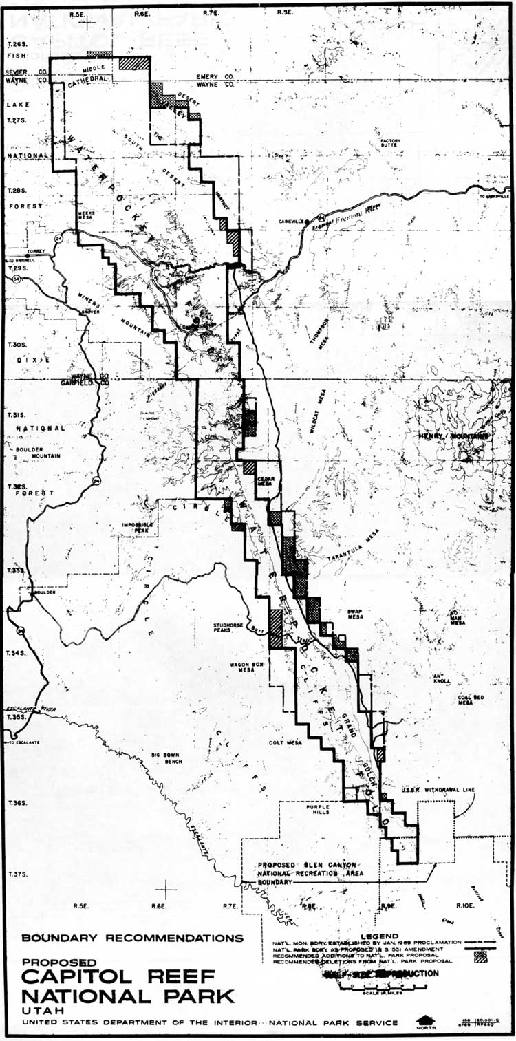
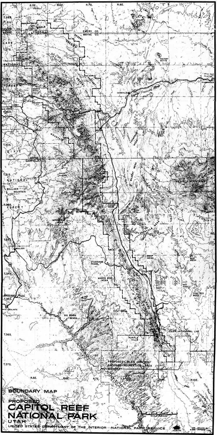
The objective of this plan was to gather a natural resource data base and then attempt to restore those natural conditions to areas altered by past grazing and mining practices. This could be accomplished if grazing and mining were significantly removed from the monument. This goal would become a resource management priority throughout the rest of the twentieth century. By June 1969, the National Park Service had determined its preferred boundaries for Capitol Reef National Park (Fig. 31). Except for a few additional sections added and some deleted from the proclamation boundaries, the National Park Service proposal was remarkably similar to Moss' S. 531. This proposal was slightly modified in August, mostly in the northwest corner of the proposed Capitol Reef National Park (Fig. 32).
Data-gathering related to the new monument resources and fiscal, physical, and personnel requirements would take a little longer to resolve. Since no bill pertaining to Capitol Reef National Monument made it out of committee for the rest of 1969, park service officials had the time they needed to gather data and proposals that could sway Congress to their point of view.
|
| Figure 31. National park boundary, as proposed by the National Park Service, June 1969. (click on image for an enlargement in a new window) |
|
| Figure 32. National Park Service proposed boundaries, August 1969. (click on image for an enlargement in a new window) |
| <<< Previous | <<< Contents >>> | Next >>> |
http://www.nps.gov/care/adhi/adhi11a.htm
Last Updated: 10-Dec-2002