|
Golden Spike
Cultural Landscape Report |

|
CHAPTER 3:
EXISTING CONDITIONS (continued)
Buildings and Structures
Currently, there are few buildings located within the existing or authorized boundaries of Golden Spike NHS. Conversely, there are numerous structures within the park, most of which are historic and associated with the CP and UP railroad grades.
Promontory Summit
Virtually all of the buildings within the summit area are modern, constructed by the park service to accommodate its various functions. The visitor center is the largest building on site. Located adjacent to the Last Spike Site, this building was completed in 1969 (Figure 34). An open-sided shelter is currently under construction adjacent to the east side of the visitor center. Also, four storage sheds are located in the administrative compound at the rear of the visitor center. Other park service constructed buildings include the ranger's residence, the engine house and the maintenance building. In addition, the bone yard includes three small buildings used for storage purposes.

|
| Figure 34. View to south towards the visitor center from the Last Spike Site. Source: HRA 2000. |
Only one historical building remains in the summit area — the last in a series of Promontory schoolhouses. Located on private land within the authorized park boundary, it was moved to its current location after the park service acquired the land in the summit area. Currently, it is associated with a wooden windmill and some fencing — the only above-ground remains of the Snodgrass place. Finally, one structure, a metal Butler building, is located on private land north of the headquarters area. This structure is located outside the authorized park boundary.
The most prominent structure in the summit area is the 1942 SP grade, upgraded in 1979 to safely handle the reconstructed track, ballast and the steam locomotives (See Figure 32). In addition, a few modern culverts with mortared stone headwalls can be found in the area between the visitor center and the Last Spike Site, where they control drainage through the site (Figure 35).
|
| Figure 35. Modern culvert headwall near visitor center. Source: HRA 2000. |
West Slope and East Slope
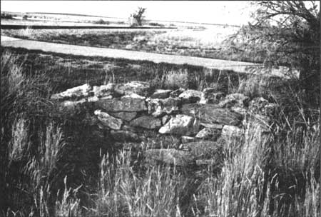
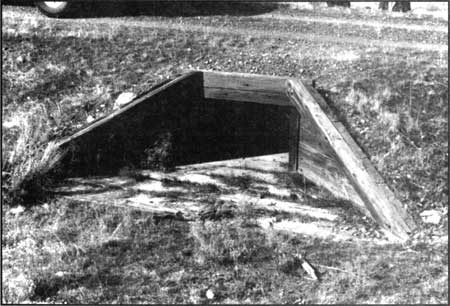
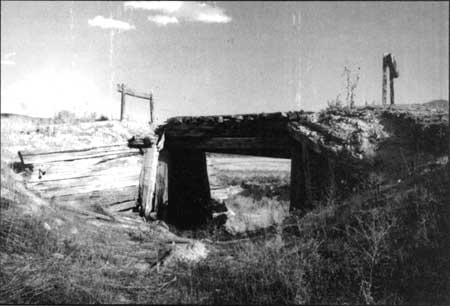
The west and east slopes contain no historic or modern buildings. However, the majority of the engineered structures associated with the transcontinental railroad are located in this area. In addition to the CP and UP railroad grades, each of which is counted as a separate structure, twenty-four historic culverts have been identified. A variety of culverts from several time periods have been identified. The earliest culverts — those installed at the time of grade construction are made of stone, whereas later replacement culverts are constructed of wood. Many of the culverts have been stabilized and/or restored (Figures 36 and 37). The park also contains two intact trestles. Located on the east slope near Blue Creek, these structures date to the 1930s, and are in poor condition (Figure 38).

|
| Figure 36. Detail of stablized stone culvert in CP grade—west slope. Source: HRA 2000. |
|
| Figure 37. Detail of wood culvert in CP grade—west slope; Source: HRA 2000. |
|
| Figure 38. View to the southwest of Trestle No. 1. Located at east end of park near Blue Creek. Source: HRA 2000. |
| <<< Previous | <<< Contents >>> | Next >>> |
http://www.nps.gov/gosp/clr/clr3d.htm
Last Updated: 27-Jul-2003