|
Golden Spike
Cultural Landscape Report |

|
CHAPTER 4:
ANALYSIS AND EVALUATION (continued)
Topography
The construction of the railroad resulted in many manmade topographical features within the right-of-way, especially on the eastern slope of the summit. These features include numerous cuts through the rocky hills and the earthen and rock fills placed in low-lying areas, both of which were constructed in an effort to maintain the required grade. Less deliberate types of features resulted from the discard of materials used in the many cuts along the grade. Large mounds of waste line the larger cuts such as the Union Pacific's "Last Cut." On a smaller scale, changes to the topography were also undertaken within the workers' campsites where men constructed numerous trenches, pits, and dugouts, as well as tent platforms.
As indicated above, most of the manmade topographic features date to the construction period and are directly associated with the NHS's primary period of significance. However, the park service is responsible for three modern manmade features, one of which is the berm constructed to shield the engine house and maintenance building from the Last Spike Site. The second modification is the leveling and grading of the ground surface in the area between the Last Spike Site and the visitor center. The third is the pile of topsoil created during the construction of the park ranger's residence. This is located adjacent to the southeast corner of the junction of the maintenance area access road with the road to the park well.
Summary
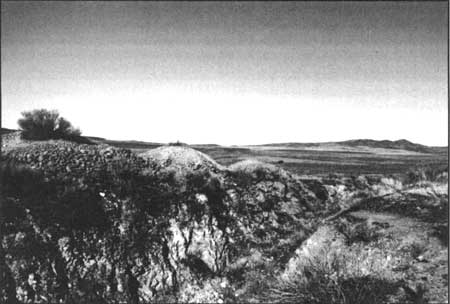
Next to circulation, "topography" is a principal, character-defining feature of the Golden Spike NHS landscape and relates most directly to the primary period of significance for the site. The manmade topographic features that characterized the construction of the railroad are still evident within the landscape. This landscape characteristic has integrity and contributes to the eligibility of the historic site. Specific contributing topographic features include the Last Cut and associated spoil piles (Figure 47), Carmichael's Cut, Little Mack's Cut, Salsbury's Cut, the Big Fill (Figure 48) and several unnamed cuts and fills. Noncontributing features include the earthen berm constructed by the park service to screen the maintenance area and the park service topsoil pile.
|
| Figure 47. View to the southwest — Union Pacific's "Last Cut." Source: HRA 2000. |

|
| Figure 48. View to the north — Central Pacific's "Big Fill." Source: HRA 2000. |
| <<< Previous | <<< Contents >>> | Next >>> |
http://www.nps.gov/gosp/clr/clr4d.htm
Last Updated: 27-Jul-2003