|
Golden Spike
Cultural Landscape Report |

|
TREATMENT (continued)
Recommendations for Treatment
Zone 1: Promontory Summit
1) Funding for a vegetation management study for the NHS has been approved, and development of a Vegetation Management Plan is underway. This study will provide information about the historic appearance of area vegetation through an environmental history and will result in development of a plan to guide the park in appropriate vegetation management. One goal of this study is the identification of appropriate plant materials for the visitor center landscaping in order to enhance the historic character of the site. Consideration should be given to removing the lawn in the vicinity of the visitor center and replanting the area with more appropriate native vegetation, similar to plant materials used in the parking area.
The Vegetation Management Plan will also address the restoration of more appropriate vegetative cover surrounding the Last Spike Site, such as the mixed stands of native grasses reported to be present in the summit basin in 1869 (as indicated on the 1868 railroad survey maps), and the sagebrush and other shrubs appearing in the 1869-1879 photographs.
2) Consideration should be given to moving the temporary trailers, 4 storage buildings, and the trailer pads for volunteers, currently located west of the administrative offices, to the vicinity of the maintenance building, east of the earthen berm. These structures are physically and visually intrusive and incompatible with the historic character of the site. Each addition to this area contributes to the growing mass of the visitor center and the cumulative adverse visual effects to the Last Spike Site.
3) No new development should be allowed in the summit area. If new development is needed for park operations or administration, all buildings and associated structures should be sited in the existing maintenance area behind the earthen berm.
4) Design guidelines for the historic site should be developed to provide guidance on the character and materials appropriate for any development within the site. Guidelines could address a variety of resources including structures such as culvert headwalls, roads and trails, vegetation, utilities, site furniture, signage and interpretative materials.
5) In order to mitigate the visual impact of the visitor center and other modern additions on the Last Spike Site, surface materials (roofing, paint) that are nonreflecting and that blend with and complement the colors found in the surrounding environment should be selected. The development of an appropriate color palate for improvements at Golden Spike NHS should be part of the design guidelines prepared for the site.
All existing buildings, structures, utilities, and other features should be evaluated to determine whether or not their exterior appearance (paint color, material surface) is compatible with the historic scene.
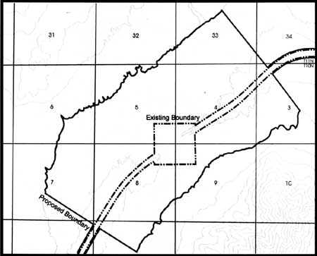
6) In order to protect critical views and the larger setting of the Last Spike Site, consider ways to protect additional lands at the summit basin. Expansion of the authorized NHS boundary to the 5000-foot contour interval within a mile east and west of the Last Spike Site (Figure 52) would incorporate most of the viewshed that is susceptible to development. By expanding the authorized boundary, park managers will have the authority to either purchase lands outright or to negotiate scenic easements with private landowners. In general, the negotiation of easements is preferred over purchasing lands in fee simple. In addition, NHS staff can work with Box Elder County officials to investigate protective zoning that would encourage agricultural land use and limit development.
|
| Figure 52. The summit area showing the suggested authorized boundary expansion. |
One priority for land purchase is a 1/4-mile-wide strip of land immediately adjacent to the west boundary of the 160-acre headquarters area. The current NHS boundary is extremely close to the Last Spike Site, and the archaeological remains of Promontory Station buildings are known to be located in this area. Fee simple ownership of this parcel of land would facilitate protection of the historic resource.
7) Continue routine maintenance of the reconstructed grade in the summit area.
8) When possible, replace the existing NHS boundary fences (metal post and wire) with materials that are more appropriate to the historic period. Juniper posts would be more compatible with the historic scene.
9) Plans are in preparation to reestablish the canvas wall tents and other temporary site furnishings in the vicinity of the Last Spike Site according to the May 10, 1869 configuration, as a means to enhance the interpretive environment. The park has recently finalized an Implementation Plan for the Reconstruction and Interpretation of the May 10, 1869 Last Spike Site Historic Scene that addresses not only the tents, but the entirety of what is most reasonable for a partial reconstruction of the historic scene. Once completed, this partial reconstruction should be maintained according to the May 10, 1869 scene as outlined in the NHS Interpretive Plan, and not expanded to encompass the development associated with the later historic periods.
10) Consider stabilization of the windmill located on the 15-acre parcel of private land owned by Johnson, east of the park's storage facility and formerly part of the historic Snodgrass property. Evaluate the National Register eligibility of the Promontory School, also located on the private parcel. Although these resources are located outside the current NHS boundary, they are within the authorized boundary. Other than archaeological resources, the school, the windmill, and the historic vegetation are the only extant reminders of the built environment of the later period of historical significance.
12) Maintain (prune and water) the two remaining box elder trees and the Golden currant. Manage the matrimony vine remaining in the vicinity of the visitor center parking lot (the former Houghton Store area), immediately northwest of the Last Spike Site in the area of the Promontory Station Section House and tie houses, and on the historic Snodgrass property.
Zone 2: West and East Slopes
1) Purchase lands already within the authorized boundary to ensure protection of the portions of the parallel grades and the archaeological remains of workers' campsites that they contain. Further expand the authorized NHS boundary to include additional lands that contain segments of the Union Pacific railroad grade and that contain the archaeological remains of workers' campsites. (Completion of the multi-year archaeological inventory of the NHS and adjacent lands known to contain evidence of construction workers' campsites should help to identify the areas that should be included in the expanded NHS boundary.)
The park should consider a boundary study to assess acquisition of other remaining segments of the Promontory Branch line. This would include the 14-mile segment between the east end of the NHS and Stinking Springs, and the 70-mile segment between the west end of the NHS and Lucin, Utah. Currently all of this land is in federal ownership, managed by the Bureau of Land Management (BLM). Extending the boundary to include the entire branch line would follow through with original historic research suggesting preservation of the entire Promontory Branch. It would benefit the historical resource by consolidating management of the entire line under one federal agency, resulting in a more standardized approach to protection and treatment. (This recommendation is consistent with proposed legislation for the Golden Spike/Crossroads of the West National Heritage Area, proposed to extend from Evanston, Wyoming, to Lucin, Utah along the historic railroad alignment).
2) Develop a plan to systematically identify, document, and monitor impacts to the historic railroad grades as a result of the auto tours. This includes not only direct impacts to the historic grade but indirect impacts on the associated resources and impacts resulting from pedestrian as well as vehicular traffic.
3) Continue preservation of structural components of the grade (culverts and trestles) as needs arise and continue to mitigate adverse impacts resulting from use of the railroad grade as an interpretive corridor.
4) Manage shrubby vegetation that threatens the structural integrity of the grades and associated archaeological sites. In the past two years, prescribed burns have been used to remove shrubby plants from the grade and from archaeological sites. [25] This method has been preferred over manual or mechanical removal, since the grade materials and the ground surface are not physically disturbed. In areas outside the grade, burning should be followed by reseeding, since burned areas are susceptible to invasion by noxious weeds. Recommendations regarding the composition of the seed mixture will be part of the vegetation management plan.
6) Consider replacing metal post and wire NHS boundary fencing with juniper post and wire fencing. Alternatively, the electric fence used in some parts of the east and west slope could also replace the metal fencing.
7) Continue annual grade maintenance procedures including clearing culverts and mowing vegetation (See Appendix B).
8) Continue to maintain the electric fence and stock crossings established along the west grade to help preserve the grade and associated features and to protect them from trampling, denuding, and erosion. The stock crossings were established in locations believed to be the least susceptible to livestock damage and were developed in consultation with the Utah State Historic Preservation Office.
9) Carefully evaluate the stabilization needs and implement necessary treatments to ensure long-term preservation of the many partially standing archeological structures and other archeological features remaining in the historic workers' campsites.
NOTE: As the treatments outlined above are completed, documentation should be appended to this cultural landscape report as Part III.
| <<< Previous | <<< Contents >>> | Next >>> |
http://www.nps.gov/gosp/clr/clr5a.htm
Last Updated: 27-Jul-2003