|
BIG BEND
The Impact of Human Use Upon the Chisos Basin and Adjacent Lands NPS Scientific Monograph No. 4 |

|
PREFACE
The purpose of this study was to evaluate the following aspects of the Chisos Basin and adjacent lands:
1. The distribution and composition of the vegetation as it presently exists.
2 The impact, present and future, upon natural conditions of camping, roads, other cultural developments, use by horses, and other human activities.
3. The distribution and composition of the vegetation as it might exist today if it was not affected by European man.
4. The nature and distribution of the soils of the area.
5. The consequences of any significant climatic changes in the area, based upon information.
6. The detrimental effects, if any, to the natural vegetation below Oak Springs and Cattail Falls because of their use as the primary water supply sources for the Chisos Basin physical development.
In addition to the evaluations of the above, recommendations will be made for management of the area to reduce or avoid unnatural changes associated with present and proposed human use. Recommendations for the rehabilitation of those areas already seriously altered by human use will also be included.
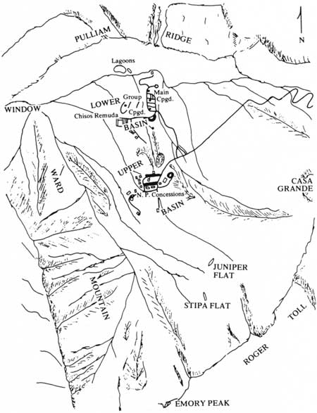
The Chisos Basin, as defined in this book, is the natural bowl bounded by Pulliam Ridge on the north, Casa Grande and Roger Toll on the east, Emory Mountain on the south, and Ward Mountain and Vernon Bailey on the west (Fig. 1). Between the latter two is the Window through which Oak Creek spills into Oak Creek Canyon below. To the south of Oak Creek Canyon is Cattail Falls, the major drainage site of the upper Ward Mountain. The Chisos Basin encompasses roughly 6 miles2 of steep, rocky terrain and ranges in elevation from 4300 ft at the Window Pouroff to 7835 ft on Emory Peak.

|
| Fig. 1. Map of the Chisos Basin. (click on image for an enlargement in a new window) |
The present major uses of the basin consist of accommodating park visitors, concessions personnel, park personnel, and providing the visitors access to more remote regions of the mountains. Two concessions are located in the basin: the National Park Concession, Inc., which provides automobile, dining, and lodging services; and the Chisos Remuda, which provides horseback trail trips to the Window and South Rim. Campgrounds, Ranger Station, Campfire Circle, and the Trailhead for the mountain trail system are provided by the National Park Service.
Because of the large area, shortness of time, and a single field investigator, the major portion of this study was conducted in the northern half of the basin where the greatest degree of human impact is centered. The southern region of the basin was crossed on two occasions, but due to the great hiking distance, detailed investigations were not conducted. All of the field work was conducted in the month of August 1969, with a single week spent in late November. The laboratory work was conducted in the Plant Ecology Laboratories at the University of Oklahoma, Norman, Okla. Voucher specimens for the study are deposited in the Bebb Herbarium at the university. All plant names in the book follow Gould (1969). The field methods employed in the study follow standard vegetational sampling procedures and will be described in detail when introduced. Slight modifications were made for convenience and vegetational requirements. The census technique employed in the trail studies was developed by the author.
I wish to express my appreciation to the National Park Service for the opportunity to conduct this timely investigation (Contract# 14-10-9-900-196) and to the University of Oklahoma Research Institute for coordinating the project. Special appreciation is extended to Superintendent Luther Peterson, Chief Naturalist Roland Wauer, Maintenance Foreman Laurie Miller, and all other Big Bend National Park personnel for their able assistance and for providing pertinent information. I am indebted to Jimmy Massey for his field assistance, plant identification, and thought-provoking discussions and to his wife, Helen, for typing the progress and final reports. To my wife, Martha, I express sincere appreciation for assistance in preparation of the manuscript.
February 1973
PAUL D. WHITSON
| <<< Previous | <<< Contents >>> | Next >>> |
preface.htm
Last Updated: 1-Apr-2005