|
CAPE LOOKOUT
Barrier Island Ecology of Cape Lookout National Seashore and Vicinity, North Carolina NPS Scientific Monograph No. 9 |

|
CHAPTER 4:
EFFECTS OF MAN ON THE OUTER BANKS
Human beings probably paid visits to the Outer Banks as long as the islands have existed. We know little about the activities of Indians on the Outer Banks, although Indian burial grounds have been found on Bogue Banks. It seems likely that the other islands were used as bases for fishing and shellfishing at least at certain times of the year. The Indians may have set fire to the grasslands at times, but grassland ecosystems recover quickly from a light burn; in general, the environmental impact of Indian use of the islands was probably rather minimal.
Technological man is another and sadder story. In colonial times small settlements of fishermen and especially of livestock raisers developed here and there along the Outer Banks. These people cut wood for fuel and boat building. This, combined with natural dune migration and sea-level rise, reduced the forest cover on several islands. In at least one important respect, however, the early settlers were more sensible than their modern counterparts; they built their houses in sheltered sound-side locations rather than on the edge of the ocean, and were safe from all but the most severe storms without the help of artificial dunes and dikes (Fig. 96). See Dunbar (1958) and Holland (1968) for comprehensive treatments of the human history of the Outer Banks.

|
| Fig. 96. Portsmouth Village was once the largest settlement on the North Carolina Outer Banks. The few buildings remaining were built a sensible distance back from the beach. |
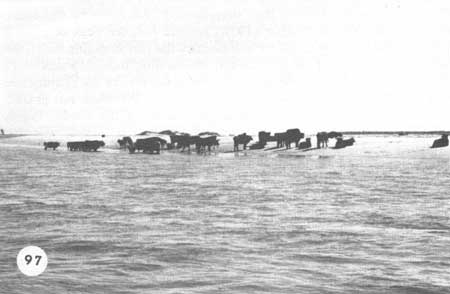
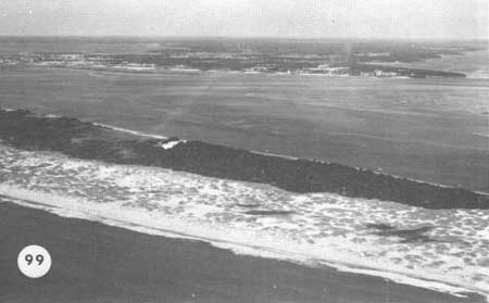
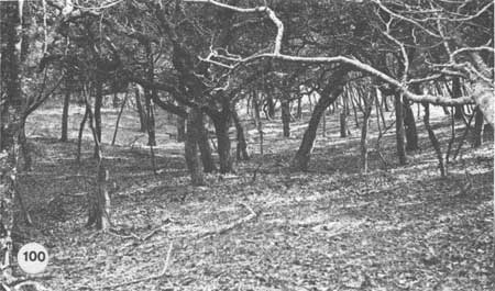
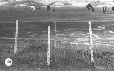
Livestock was the main industry; one could turn out one's sheep, cattle, hogs, and horses on the broad acres of dune grass and salt marsh without need of fences and know that they were safe from land-based marauders. Overgrazing apparently became a problem on some of the Outer Banks and is still troublesome on parts of Shackleford. Portsmouth Island was considered severely overgrazed as early as 1810 (Dunbar 1958). Local people tell us that before the livestock was removed from Core Banks in the 1950s, the island was nearly denuded and the animals were starving. Whether such conditions were due to overgrazing or to natural processes during that time is difficult to determine. Nevertheless, grassland ecosystems of Core Banks are healthy today, illustrating how quickly the islands can recover if allowed to do so. Portsmouth Island, which has had the longest and most severe grazing history, seems unfortunately to have been damaged beyond its natural ability to repair itself. Most of the island is a low, bare flat, awash with every high tide as were other islands on the Outer Banks (Ocracoke, Bodie) before dune-building projects were begun in the 1930s; the land-building processes of overwash and dune formation are not working here. This is the only one of the undeveloped barrier islands which might accurately be said to be "washing away." Extreme overgrazing followed by some bad storms may have been responsible for the present condition of Portsmouth. On Shackleford Banks there are still herds of sheep, goats, cows (Fig. 97), and horses, and the damage they do is evident, yet the conditions of Portsmouth have not developed here. In the dunes the herds graze selectively on Andropogon scoparius and also reduce the cover of Uniola paniculata (Fig. 98), but the worst effects are blowouts and open sand due to trampling, which can speed up dune movement (Fig. 99). In the maritime forest there is a distinct browse line on the trees—mostly due to the goats—and tree reproduction is doubtless impaired (Fig. 100). But it is in the salt marshes that grazing takes its worst toll (Fig. 101). The marshes are the main feeding ground of the island's horses, and they bite the Spartina down to within an inch of the mud, which must significantly reduce estuarine productivity in this locality.
|
| Fig. 97. Feral cattle on Shackleford Banks, remnants of once large herds. |

|
| Fig. 98. Effects of grazing on the Shackleford dunes; the square area represents an exclosure before the fencing was stolen. During a year of relief from grazing, the cover inside the fence increased significantly, particularly Andropogon, which is selectively grazed. |
|
| Fig. 99. The network of paths and openings among the Shackleford dunes is partly cattle and horse trails. |
|
| Fig. 100. The parklike appearance of Shackleford woods is due to browsing. |
|
| Fig. 101. Part of the Shackleford horse herd and some of the salt marsh they have grazed down to the mud. After 2 years, the standing crop of Spartina alterniflora inside the exclosure was 30 times that on the outside. |
The overall effects of grazing animals on the Outer Banks are difficult to assess. Some localized areas were undoubtedly overgrazed and thus livestock were blamed for the "deteriorated" condition of the entire Outer Banks. Yet, as Dunbar (1958) pointed out, the peak of grazing pressure exceeded by at least a half century the period during which the animals were blamed for this alleged destruction. Indeed, Shackleford Banks, which had extensive moving dunes at the turn of the century and was never stabilized by human activities, yet all the while was grazed, now has extensive vegetation cover over most of the island. Engels (1952) felt that the general nature of the barrier islands was due primarily to natural forces, and our research seems to support that view, although localized grazing pressure could lead to more rapid sand movement than would normally be expected.
Livestock were not the only animals introduced. With the settlers came the inevitable house mice and rats, as well as a population of feral cats. The latter doubtless do a service in controlling the rodents, but certainly prey upon the islands' many species of ground-nesting birds as well.
Finally, certain game birds and animals, such as pheasants and raccoons, have been brought to the islands for hunting, but these seem to have fitted into the island ecosystems without noticeable dislocation of the systems.
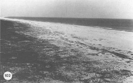
Plants have been introduced on the Outer Banks as well as animals. The use of Ammophila (whose natural range is north of Cape Hatteras) as a dune-building grass has already been mentioned. Populus alba (silverleaf poplar) and Gaillardia, a colorful composite, were brought in by the settlers as ornamentals. The poplar survives in scattered locations, especially in Portsmouth Village and villages on the Hatteras Banks, but the Gaillardia has spread everywhere. There is no indication that it has displaced any native species, however, and it performs a sand-binding service. Loblolly pines and some exotic species of Pinus were planted in the Cape Lookout area in recent years in a well-meant attempt to control sand movement. How long they will survive and how much good they will do are uncertain, but the tracks of the truck used to plant them are still visible on the grassland and may remain so for some time (Fig. 102).
|
| Fig. 102. A 1971 photo of Core Banks showing the tracks of the vehicle used to plant pine trees in 1969. These tracks will be here for some time. |
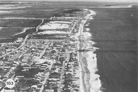
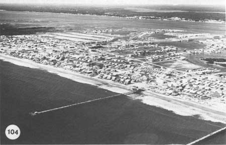
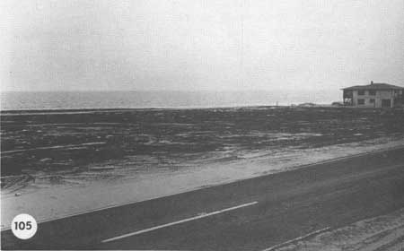
Modern development of the Outer Banks has usually proceeded with unfortunate disregard for the dynamics of the environment (Fig. 103). Houses, motels, roads, and recreational facilities not only mean inevitable destruction of dunes, woodland, or salt marshes where they are built (Fig. 104), but they require engineering work for protection from the sea. The difficulties that arise from building artificial dunes and from preventing overwash and island migration have already been discussed. On privately owned sections of Bogue Banks and elsewhere along the North Carolina coast, developers have leveled the fore-dune in order to build as close to the sea as possible and have removed maritime forests to create lots for homes (Fig. 105). The inevitable result is rapidly moving sand and storm flooding on a part of the island which grass and trees took years to stabilize. In addition, exposed trees soon die from salt spray since they are no longer protected by dunes or seaward vegetation.
|
| Fig. 103. The effects of modern development on Bogue Banks; contrast with the undeveloped beach in Fig. 102. |
|
| Fig. 104. Bogue Banks at Atlantic Beach. Marshes have been dredged and bays filled for housing developments and trailer parks. All are vulnerable to a big hurricane. |
|
| Fig. 105. Dunes leveled by a developer on Bogue Banks. |
| <<< Previous | <<< Contents >>> | Next >>> |
chap4.htm
Last Updated: 21-Oct-2005