|
KINGS CANYON
Guidebook 1941 |

|
| OPEN ALL YEAR |
 |
KINGS CANYON NATIONAL PARK CALIFORNIA |
||
|
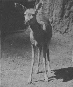
MULE DEER ARE SEEN EVERYWHERE IN THE PARK
| ||||
KINGS CANYON NATIONAL PARK was created by act of Congress, May 4, 1940. It comprises 710 square miles of superlative mountain scenery in the heart of the Sierra Nevada and three groves of giant sequoias. In the creation of this park, the former General Grant National Park, with the addition of the Redwood Mountain area, became the General Grant Grove Section. This section is the gateway to the Kings Canyon and the High Sierra wilderness and is a center for tourist travel. The main portion of the park includes the watersheds of the South and Middle Forks of the Kings River and the Evolution Creek and Goddard Canyon watershed, tributary to the South Fork of the San Joaquin River. It includes also the crest of the Sierra Nevada and western slope from Junction Peak to Mount Lamarck, a summit area containing four peaks over 14,000 feet in altitude, and more than twenty others above 13,000 feet in altitude.
Granite gorges, mountain meadows, and trout-filled streams and lakes abound. The Monarch Divide, which is accessible by road, separates the two great South Fork and Middle Fork Canyons. The Middle Fork is reached only by trail by crossing over Granite Pass or Cartridge Pass, by traversing the 12,000-foot Mather Pass on the John Muir Trail, or by descending from road end at Cliff Camp on the North Fork of the Kings into Tehipite Valley to view the famous Tehipite Dome.
In this new wilderness park accommodations will be kept to a minimum. Access roads lead to trails entering the park through national forests from both the east and west sides. The real beauties of the park are available only to those who ride horseback or hike the many trails which lead to unexcelled campgrounds.
The John Muir Trail follows through the entire summit region of the park for 78 miles, seldom below 8,500 feet, and crosses five high mountain passes.
Fourteen miles southeast of the General Grant Grove Section lies the Sequoia National Park. The two Big Tree national parks are linked by one of the finest mountain roads in America—the Generals Highway. This highway reaches a 7,600-foot elevation at Big Baldy Saddle, passing through heavy forests of pine, fir, cedar and Sequoia gigantea the whole length, and affording spacious views of the mountain and foothill country stretching to the San Joaquin Valley, an opaline haze in the distance.
A DESCRIPTION OF KINGS CANYON BY JOHN MUIR (1838-1914)
"In the vast Sierra Wilderness far to the southward of the famous Yosemite Valley, there is a yet grander valley of the same kind. It is situated on the south fork of King's River, above the most extensive groves and forests of the giant sequoia, and beneath the shadows of the highest mountains in the range, where the canyons are deepest and the snow-laden peaks are crowded most closely together. It is called the Big King's River Canyon, or King's River Yosemite, * * *. It is about ten miles long, half a mile wide, and the stupendous rocks of purplish gray granite that form the walls are from 2,500 to 5,000 feet in height, while the depth of the valley below the general surface of the mountain mass from which it has been carved is considerably more than a mile.
* * * * *
"The bottom of the valley is about 5,000 feet above the sea, and its level or gently sloping surface is diversified with flowery meadows and groves and open sunny flats, through the midst of which the crystal river, ever changing, ever beautiful, makes its way; now gliding softly with scarce a ripple over beds of brown pebbles, now rushing and leaping in wild exultation across avalanche rock-dams or terminal moraines, swaying from side to side, beaten with sunshine, or embowered with leaning pines and firs, alders, willows, and tall balsam poplars, which with the bushes and grass at their feet make charming banks. Gnarled snags and stumps here and there reach out from the banks, making cover for trout which seem to have caught their colors from rainbow spray, though hiding mostly in shadows, where the current swirls slowly and protecting sedges and willows dip their leaves.
* * * * *
"From the brink of the walls on either side the ground still rises in a series of ice-carved ridges and basins, superbly forested and adorned with many small lakes and meadows, where deer and bear find grateful homes; while from the head of the valley mountains other mountains rise beyond in glorious array, every one of them shining with rock crystals and snow, and with a network of streams that sing their way down from lake to lake through a labyrinth of ice-burnished canyons. The area of the basins drained by the streams entering the valley is about 450 square miles, and the elevation of the rim of the general basin is from 9,000 to upward of 14,000 feet above the sea; while the general basin of the Merced Yosemite has an area of 250 square miles, and its elevation is much lower.
* * * * *

MIDDLE FORK OF THE KINGS RIVER
"At the head of the valley the river forks, the heavier branch turning northward, and on this branch there is another Yosemite, called from its flowery beauty Paradise Valley; and the name might well be applied to the main canyon, for notwithstanding its tremendous rockiness, it is an Eden of plant-beauty from end to end."
THE GROVES
The General Grant Tree in the Grant Grove of Big Trees is so huge its size is difficult to comprehend. Its greatest horizontal diameter is 40.3 feet at the base, and at 200 feet above the ground its diameter is about 12 feet. This tree is 267 feet high and is one of the most celebrated trees in the United States, having been dedicated as the Nation's Christmas Tree. Huge specimens of sugar and ponderosa pine, fir, and cedar in this grove and in the nearby North Grove arouse interest second only to that of the giant sequoias themselves.
Six miles toward Sequoia National Park, just off the Generals Highway, is the Redwood Mountain Grove of sequoias. Towering in close-ranked companies along the crest of a prominent mountain ridge, and etched in bold relief against the sky, these forest giants march down the slopes of the mountain and spread out in stately groves over the canyon floor immediately below. Nowhere else do giant sequoias stand out so prominently on a ridge, silhouetted against the sky. The Hart Tree is considered the fourth largest sequoia. Thousands of young trees are present.
Seven giant sequoias, averaging 10 feet in diameter and 200 feet high, are on one acre. There are at least 7,000 sequoias with a diameter exceeding 2 feet, and, though many of the older trees show fire scars, there have been no recent fires.
Adding to the grandeur of the sequoia groves of Redwood Mountain and Canyon are superlative stands of sugar pines and western yellow (or ponderosa) pines, many of them 200 feet tall, a few even taller, likewise accompanied by an abundance of young growth of their own kind and by a scattering of firs, cedars, and a few other species. The net result is a primeval forest of supreme wilderness beauty, as yet largely unspoiled, with thousands of sequoias ranging from tiny seedlings up to magnificent old patriarchs 2,000 and perhaps 3,000 years old.
FORESTS AND FLOWERS
Coniferous trees predominate. There are eight species of pines found in the park, including the one-leaved, or piñon pine. The mountain hemlock and white-barked pine are timber line trees. The Kellogg black oak frequents the valleys, and the golden-cupped, or canyon live oak, the talus slopes. The Nuttall dogwood produces a wealth of white blossoms in the spring and colorful foliage in the fall. Azaleas around the meadows are a blaze of glory in the spring. Meadows are abloom in June and July. Conspicuous are the leopard lilies and pentstemon of several varieties, Indian paintbrush, larkspur, shooting stars, and Queen Anne's lace.
WILDLIFE
California mule deer, black bear, and several species of squirrel are the best known animals of the park. A few bighorn, or mountain sheep, remain along the crest of the Sierra. Bears are found throughout the park, but not in large numbers. Feeding of these animals by visitors is strictly prohibited. When this regulation is followed, the bears cause very little trouble to campers. Pine martens, marmots, and conies inhabit the high elevations. The Columbia gray squirrel is a common sight as it dashes across roads and trails, a blue-gray vision that at times appears to be all tail. The Douglas squirrel, or Sierra chickaree, gray-brown in color, is well known for its amusing habit of scolding. Birds are numerous. Mountain quail and Sierra grouse are encountered on trail trips, and notable birds of the high mountain areas are: golden eagle, rosy finch, Clark's nutcracker, and water ouzel. The Park Information Office at General Grant Grove Section is headquarters for information about plants, birds, and animals.
FISHING
Excellent trout fishing in over 200 lakes and in more than 150 miles of streams is to be found in this park. Native rainbow trout is abundant, and golden trout has been introduced from the Kern Basin. Some eastern brook trout is found in high mountain lakes. Banks of streams are largely free from vegetation, and conditions for fly fishing are excellent in late summer and early fall. State seasons and limits prevail, and a State fishing license is required.
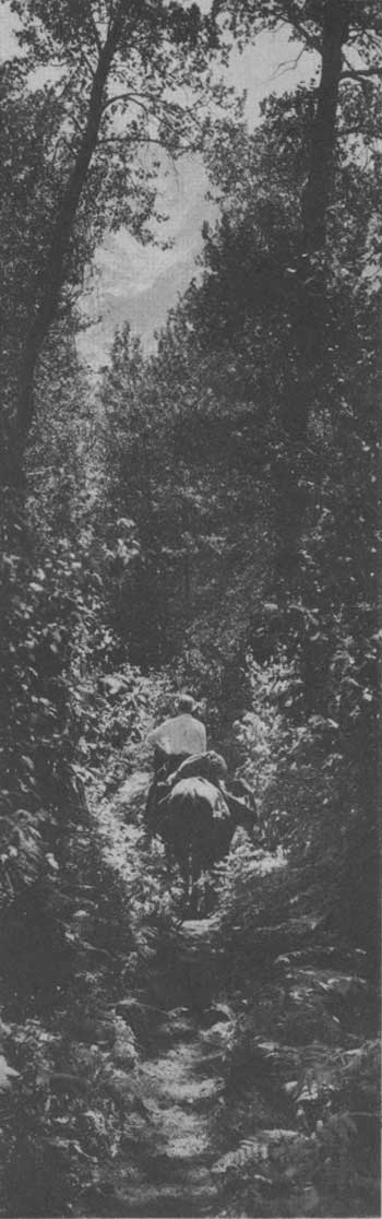
RIDING A TRAIL TO THE HIGH COUNTRY
TRAILS
The trail system at the General Grant Grove Section offers the hiker or horseback rider miles of well-graded pathways to many lovely sections of the park.
The John Muir Trail traverses the main section of the park from end to end, being the main summit trail route between Yosemite and Sequoia National Parks. This trail affords the mountaineer an opportunity to penetrate spectacular mountain country. The peaks, cliffs, lakes, streams, and meadows of this portion of the High Sierra offer unusual scenic attractions to the summer visitor.
The main trails leading into scenic portions of the park from the west are the Copper Creek Trail over Granite Pass to Simpson Meadows on the Middle Fork, the Tehipite, Evolution Basin, and Bishop Pass Trails, and Kearsarge Pass Trail over the crest from Inyo County to the east. A favorite loop trip for knapsackers and packers is from the floor of Kings Canyon up the South Fork to Paradise Valley, up Woods Creek to Rae Lakes and Glenn Pass (11,900 feet) and thence down Bubbs Creek to Kings Canyon. Trails lead over four different passes into Sequoia National Park.
There are no restrictions on camping in the back country, except precautions against fire and proper sanitary measures. Hikers and those with pack animals must carry their own equipment. Camping grounds on the Middle Fork are found at Little Pete, Grouse, and Simpson Meadows, and Tehipite Valley; on the South Fork are Paradise Valley, Woods Creek, Rae Lakes, Vidette Meadows on Bubbs Creek, and Scaffold Meadows on Roaring River.
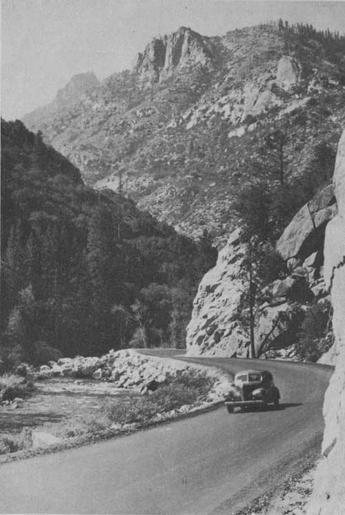
UP THE RIVER TO KINGS CANYON
PARK SEASON
The General Grant Grove in Kings Canyon National Park is open all year, with Federal and State authorities cooperating to clear the roads in winter. It is seldom that travel is interrupted more than a day or two. Campgrounds are not open during the winter season, but informal accommodations are available in the General Grant Grove Section. All forms of winter sports, except skating, are enjoyed, and snowshoes, skis, and toboggans may be rented at reasonable prices in the General Grant Grove Section.
During the winter season, meals and accommodations are to be had at the coffee shop at park headquarters in the General Grant Grove Section. Entrances over high mountain passes are not open to travel until after July 1.
ADMINISTRATION
The Kings Canyon National Park is administered by the National Park Service of the United States Department of the Interior. The representative of this bureau in direct charge of the park is the Assistant Superintendent. Administrative headquarters is at the Plaza, near the center of the General Grant Grove Section. All-year mail, telephone, and telegraph service is maintained at this point. The post office address is Kings Canyon National Park, Calif.
NATURALIST SERVICE
Many forms of outdoor activities are encouraged in Kings Canyon National Park, but special attention is paid to fostering a knowledge of the wildlife and natural beauty which the park was created to preserve. At the Plaza in the General Grant Grove Section, a ranger-naturalist is in charge of the educational program, which includes guided field trips, automobile caravans, and camp fire entertainments. There are talks on the giant sequoias and other natural features by rangers, and music and informal entertainment by visitors.
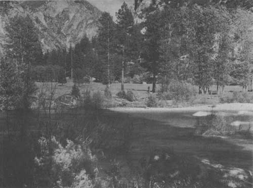
LOOKING ACROSS KINGS RIVER AT ZUMNWALT MEADOWS
General Grant Grove Section has a very fine outdoor amphitheatre, with a seating capacity of 1,200. Programs are given here and at Cedar Grove two or three times a week.
FREE CAMPGROUNDS
There are five improved campgrounds in the General Grant Grove Section, located among the pines, firs, and cedars of the plateau and ridges near park headquarters. Comfort stations, with hot and cold showers, are conveniently located, spring water is piped through the camping areas, and firewood is kept constantly replenished.
At Cedar Grove are three large campgrounds with comfort stations, running water, tables and stoves, and wood. Camping provisions are available in the campgrounds.
CHRISTMAS TREE CEREMONY
At high noon on Christmas Day each year, devotional and patriotic services are held beneath the General Grant Tree, designated in 1925 as the Nation's Christmas Tree. These services have been broadcast over Nation-wide hook-ups, and Presidential messages have constituted a part of the program. When the weather is favorable, a large audience attends this unique ceremony.
CHURCH SERVICES
Sunday morning services and Sunday school are conducted during the season by the Church of the Sequoias at the religious headquarters near the park amphitheatre and at Cedar Grove Campground. Evening vesper services or an evening program of religious instruction, with illustrated lectures, feature Sunday evening presentations.
RAILROAD, BUS AND AIRPLANE SERVICES
The Southern Pacific Railroad serves Fresno, Visalia, and Exeter; the Santa Fe Railway reaches Fresno, Corcoran, and Hanford. Busses take Santa Fe passengers from Corcoran and Hanford to Visalia. From Visalia and Fresno park busses are available during the summer season. Pacific Greyhound and Santa Fe busses, as well as planes of the United Airlines, connect at Fresno. There is also an airplane landing field at Visalia.
The stage service to Sequoia and Kings Canyon National Parks is a circle tour in one direction only from Fresno, via Visalia and Exeter, to Giant Forest in the Sequoia National Park, thence via the Generals Highway to the General Grant Grove Section of Kings Canyon National Park, returning direct to Fresno. From June 10 to September 10, an auto stage of the Sequoia and General Grant National Parks Co. leaves Fresno daily at 8:15 a. m. by way of Visalia and Exeter, arriving at Giant Forest about 12:15 p. m. An auto stage leaves Giant Forest at 1:45 p. m. for the return trip to Fresno, via the General Grant Grove Section, over the spectacular Generals Highway, arriving at Fresno 6:30 p. m. Stops are made at General Sherman Tree in Giant Forest, General Grant Tree in Grant Grove of Big Trees, and other interesting places en route. Round trip fare from Fresno, Visalia, or Exeter and return over circle tour route and schedule above, with stopover privileges in Giant Forest and General Grant Grove Section, $10 a passenger. From Fresno, Visalia, or Exeter to the General Grant Grove Section, via Giant Forest, $8 per, passenger. "On Call" stage service by advance reservation is available from Fresno to the General Grant Grove Section direct (not including Sequoia National Park) at $6, one way, and $9, round trip. All-expense tours, including sightseeing and all accommodations and transportation, are available at $11 for one day tour; $17.50 for two day tour. This circle tour service enables travelers to visit both national parks easily.
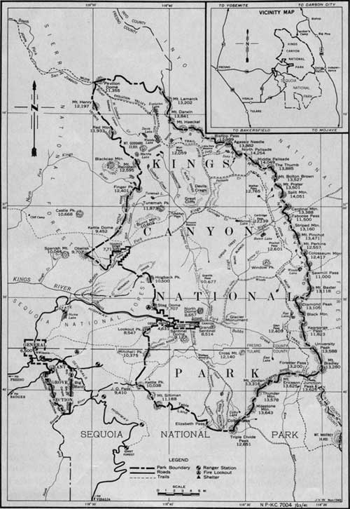
MAP OF KINGS CANYON NATIONAL PARK
(click on image for a PDF version)
APPROACH TO PARK BY HIGHWAY AND TRAIL
Main Entrance: 1. From Fresno, over new entrance highway, 56 miles; over old Highway No. 180, via Pinehurst, 64 miles; or from Visalia on Highway 65, 53 miles; to General Grant Grove Section, and thence to the floor of the South Fork of Kings River Canyon, 30 miles. This new State road into the canyon ends at Cedar Grove in the Sequoia National Forest, where public campgrounds, now administered by the National Park Service, are available.
Trips up the canyon into the park, or into the high country, must be made on foot or on horseback: Cedar Grove to Kanawyers, on Copper Creek, 8 miles; Paradise Valley, 12.8 miles; Vidette Meadows, 19.8 miles; Kearsarge Pass, 28 miles; Simpson Meadows, on Middle Fork, 28 miles.
2. From Fresno, via the Shaver Lake Road, Highway 168, with turnoff at Shaver Lake, to Dinkey Creek and to Cliff Camp, thence by trail to Gnat Meadow, 14 miles; also by rough road via Trimmer and Balch Power House to Crabtrees, and thence by the poor and very steep Tehipite Trail to Tehipite Valley, on the Middle Fork of Kings River, Simpson Meadows, 29 miles; or over Hell-for-Sure Pass, 11,300 feet, 25 miles, into Goddard Canyon, 28 miles; or Evolution Valley, 33 miles.
3. From Visalia (53 miles), Highway 65, to General Grant Grove Section, and thence along the Generals Highway toward Giant Forest, 8 miles, to a side road to Big Meadows and extended narrow road to Horse Corral Meadow; thence by trail to the floor of the South Fork of Kings River Canyon, via either the Sheep Creek Trail to Cedar Grove, 8 miles; or Scaffold Meadow and the Sphinx Trail to Bubbs Creek, 21 miles.
4. From Visalia or Exeter to Giant Forest in Sequoia National Park on Highway 198; and by the Generals Highway to General Grant Grove Section, 30 miles; and State Highway No. 180, to the floor of Kings Canyon, 30 miles; or by trail from Giant Forest over J. O. Pass (9,410 feet), Cedar Grove, 22 miles; or by Elizabeth Pass (11,200 feet), or Colby Pass (12,000 feet), or Foresters Pass (13,200 feet), from Sequoia National Park.
5. From Fresno to Huntington Lake, Highway 168, to end of road at Florence Lake, 84 miles; thence by trail through Blaney Meadows, 6 miles; Colby Meadows, in Evolution Valley, 18.6 miles; Muir Pass, 30.4 miles.
East Side Entrances: 1. An easy approach by road is from Bishop, Inyo County, up Bishop Creek, Highway 168, to Parcher's Resort, 20 miles; and thence by trail over Bishop Pass (12,000 feet), 7 miles, and down Duzy Creek to the Middle Fork of Kings River, 12 miles; Simpson Meadows, 25.2 miles.
2. From Junction on Highway 6, 8 miles north of Independence, Inyo County, via Sawmill Creek Road, 2 miles; and thence by trail over Sawmill Pass to Woods Lake and Woods Creek, 10.5 miles; Rae Lakes, 17.5 miles; Sixty Lake Basin, 24.7 miles.
3. Easiest approach is from Independence, Inyo County, via Independence Creek Road, Highway 180, to Onion Valley; thence by trail over Kearsarge Pass (11,823 feet), 4 miles, to Bullfrog Lakes, 6 miles; to head of Bubbs Creek, 7.2 miles; Glenn Pass, 8.2 miles; Rae Lakes, 11.6 miles.
4. From Independence, Inyo County, up Symmes Creek Road, 9 miles; and thence by trail over Shepherd Pass, 7.5 miles; to Tyndall Creek, 11.5 miles; and over Foresters Pass (13,200 feet), 16.5 miles; into Bubbs Creek, 23.5 miles.
5. From Lone Pine, Inyo County, to Whitney Portal, 14 miles; thence by trail over Whitney Pass, 12 miles; and Foresters Pass, 35.5 miles—park boundary—open only after middle of July; and head of Bubbs Creek, 42.5 miles. This is the best route if trip to Mount Whitney is included.
ACCOMMODATIONS AND EXPENSES
The nearest lodge and cabin facilities within the Kings Canyon National Park are to be found at the General Grant Grove Section and at Giant Forest, Sequoia National Park. It is 30 miles from the General Grant Grove Section by the State Highway to Cedar Grove on the floor of Kings Canyon; and from Giant Forest it is 30 miles to the General Grant Grove Section over the Generals Highway. Trips to the floor of Kings Canyon can be made easily from either of these two points.
Grant Grove Lodge and Meadow Shelter Camp in the General Grant Grove Section are operated by the Sequoia and General Grant National Parks Co. The season is from May 15 to November 15. Grant Grove Lodge is a colony of comfortable rustic cabins, with and without private bath, and bungalow tent cottages grouped around a central office and lounge building with massive stone fireplace. A modern sanitary toilet and bathhouse is centrally located. European plan lodging rates range in price from $2.50 a day for two persons in a room without bath (double bed) to $6 a day for two persons in a room with bath (twin beds). A few bungalow tents are completely equipped for housekeeping with all necessary utensils, bedding, and linen. The rent by the day is from $2 for one person to $4.50 for five. By the week, the rates for these housekeeping cottages range from $12 for one person to $27 for five. Water for drinking and cooking is piped conveniently to each camp, and laundry tubs with hot water are available without extra charge.
At Meadow Shelter Camp are partially furnished housekeeping cabins equipped with furniture, but no bedding or utensils. The rates are $1.50 a day for one or two persons and 50c a day for each additional person. Linen, blankets, and all other camping equipment may be rented. A modern sanitary toilet and bathhouse is centrally located, and laundry tubs with hot water are available without extra charge.
In Grant Grove Village there is a Coffee Shop where combination breakfasts are provided from 25 cents to 65 cents and luncheons and dinners from 50 cents to $1, as well as sandwich and a la carte service. A soda fountain is located in the Coffee Shop, and photographic supplies and souvenirs are obtainable at the Studio. At Grant Grove Market, supplies of all kinds are available, including staple groceries and canned goods, fresh meats, produce, milk, baked goods, drug sundries, hardware, fishing tackle, etc. Fishing licenses are obtainable at the market. There are also a service station and repair garage equipped for emergency road service.
For further information on transportation and all accommodations and services address: Sequoia and General Grant National Parks Co., Sequoia National Park, Calif.
This booklet is issued once a year and the rates mentioned herein may have changed slightly since issuance, but the latest rates approved by the Secretary of the Interior are on file at park headquarters.
The following resorts in the Sequoia National Forest are located conveniently on or near the entrance highway:
Hume Lake Resort—Hotel, store, cabins, free campgrounds, 4 miles distant on a side road.
Barton's Resort—Gas, cabins, light lunches, soft drinks.
Horseshoe Bend Resort.—Service station, AAA towing, store, cabin, meals.
MISCELLANEOUS SERVICES
At General Grant Grove Section will be found the following facilities: Post office; telephone; free county library; village market offering groceries, meats, fresh vegetables, and milk, at reasonable prices; gasoline service station; saddle and pack horses; curios; and coffee shop.
SADDLE HORSES AND PACK STOCK
Pack trips to Kings Canyon and other sections of the High Sierra may be arranged. Saddle horses and pack mules cost $1.50 to $3 a day; burros, $1 a day; guides or packers, $5 a day; cooks, $6 a day. Riding and pack animals can be obtained at various places. The names and addresses of these packers may be secured by addressing the Assistant Superintendent, Kings Canyon National Park, Calif.
SELECTED BIBLIOGRAPHY
Brewer, William H. "Up and Down California in 1860-1864." Yale University Press, New Haven. 1930.
Farquhar, Francis P. "Place Names of the High Sierra." Sierra Club, San Francisco. 1926. "Exploration of the Sierra Nevada." California Historical Society Quarterly. San Francisco, California. March 1923.
Fry, Walter, and White, John R. "The Big Trees." Stanford University Press. 1930. Revised edition 1938.
Jordan, David Starr. "The Alps of the King (s) Kern Divide." San Francisco. 1907.
King, Clarence. "Mountaineering in the Sierra Nevada." 1872. New editions 1874, 1902, 1935.
Matthes, Francois E. "Kings River Canyon and Yosemite Valley." Sierra Club Bulletin, 1926, Vol. 12, No. 3.
Muir, John. "Our National Parks." 1901 and later editions. "A Rival of the Yosemite." Century Magazine, November 1891.
Shirley, Clifford J. "Redwoods of Coast and Sierra." 1936.
Starr, Walter A., Jr. "Guide to the John Muir Trail and the High Sierra Region." Sierra Club. San Francisco, 1934.
White, Stewart Edward. "The Pass." 1906. "The Mountains," 1904.
Whitney, Joseph Dwight. "Reports of the Geological Survey of California." Geology, Vol. 1, 1863. Sierra Club Bulletins, 1893 to date.
MAPS
U. S. Geological Survey Topographic Maps: Mount Goddard, Bishop, Tehipite, and Mount Whitney Quadrangles. Price, 10c each. From Geological Survey, Washington, D. C
National Park Service Administrative Map of Sequoia and General Grant National Parks. Price, 25 cents each. From Geological Survey, Washington, D. C.
RULES AND REGULATIONS
(Briefed)
Let no one say, and say it to your shame,
That all was beauty here until you came.
The park regulations are designed for the protection of the natural beauties and scenery as well as for the comfort and convenience of visitors. Complete regulations may be seen at park headquarters. The following synopsis is for the general guidance of visitors, who are requested to assist the administration by observing the rules.
Park Signs—Please read them; they are for your protection and guidance.
Fires.—Light carefully and in designated places. Extinguish completely before leaving camp even for temporary absence. Do not guess your fire is out—know it.
Smoking Restrictions.—No smoking will be allowed during the fire season while visitors are in motion on roads or trails in the park. Smoking is permitted in camps or at stations. Warning signs will indicate the season of fire hazards and will be removed only when danger from this source is over. Watch the signs.
Camps.—Keep your camp clean. As far as possible burn garbage in camp fire and put empty cans and residue into garbage cans or pits provided. If no can or pit is provided, bury the refuse.
Trash.—Do not throw paper, lunch refuse, kodak cartons, chewing gum paper, or other trash on trails, roads, or elsewhere. Carry until you can burn in camp or place in receptacle.
Trees, Shrubs, Flowers.—Do not touch them until you know the regulations. Dead and down timber, except sequoia, may be used for firewood. Live growth must not be in any way injured.
Animals, Birds.—Do not kill, capture, or scare. They are your friends. Feeding, touching, teasing, or molesting bears is prohibited.
Dogs and Cats.—Dogs and cats are prohibited on the Government lands in the park unless such animals are on leash, crated, or otherwise under physical restrictive control at all times: Provided, however, that the Superintendent may designate areas to which dogs and cats may not be admitted.
Fishing.—Get a State license. Special limits apply in certain streams; otherwise the limit is 15 fish a day or 7 pounds and 1 fish. Avoid closed waters.
Hunting, Firearms.—Hunting and trapping are not allowed in the park. Firearms. Must be sealed at entrance.
Noises.—Be quiet in camp after 10 p. m. Many people come here for rest. No outboard motors allowed on lakes or streams.
Automobiles.—Drive carefully. Keep cutouts closed. Obey park traffic rules. The automobile, trailer, or motorcycle is $1, good for calendar year in Kings Canyon and Sequoia National Parks.
Park Rangers.—The rangers are here to help and advise you as well as to enforce the regulations. When in doubt, ask a ranger.
Penalties.—Please study the regulations. We shall enforce them as courteously and liberally as possible; but deliberate infraction may bring penalty not to exceed $500 fine or 6 months imprisonment, or both.
| <<< Previous | <<< Contents>>> |
1941/kica/sec1.htm
Last Updated: 20-Jun-2010