|
SCOTTS BLUFF National Monument |
 |

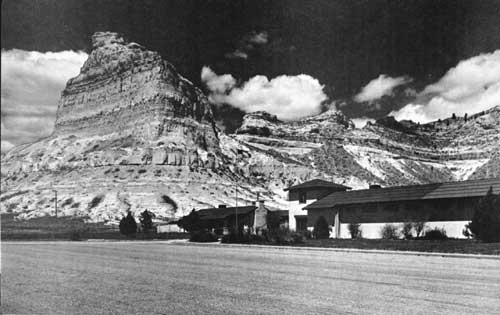
Scotts Bluff Visitor Center.
Courtesy Christian Studio, Gering, Nebr.
SCOTTS BLUFF was a celebrated landmark on the great North Platte Valley trunkline of "the Oregon Trail," the traditional route of overland migration to Oregon, California, and Utah. Today the massive castellated bluff looks down upon concrete highways, railways, airports, irrigated farms, and bustling communities of the mid-20th century; but it is the same awe-inspiring sentinel which 100 years ago watched the passage of countless trains of ox-drawn covered wagons, and the twinkling of many campfires. Scotts Bluff National Monument keeps alive the epic story of our ancestors who dared cross the wilderness of plains and mountains to plant the western stars in the American flag.
Present Scotts Bluff is but a part of the historic "Scott's Bluffs" named for Hiram Scott, an employee of the Rocky Mountain Fur Company, whose skeleton was found in the vicinity in 1829. The first known published reference is to be found in The Adventures of Captain Bonneville, by Washington Irving, published in 1837. The first map to show this landmark is in Robert Greenhow's Memoir, Historical and Political on the Northwest Coast of North America, published in 1840. It appeared next in the Fremont map of 1843, which became basic for later emigrant guides.

Early Exploration of the Great Plains
In 1540 the Spaniard Coronado captained a treasure-hunting expedition from Mexico across Arizona, New Mexico, and the Texas Panhandle. From there he led a picked detachment of armored horsemen to mythical Quivira, which proved to be only a squalid Indian village in central Kansas. Contrary to long-held belief, Coronado never reached present Nebraska. The first Spaniards known to have penetrated this state—an exploring party of 1720 led by Pedro de Villasur— were massacred by Pawnees at the forks of the Platte.
Following LaSalle's traverse of the Mississippi and the establishment of French settlements along that river, several French explorers—notably Bourgmont and Charlevois—penetrated the fringe of the Great Plains, bringing back reports of strange shaggy beasts in numbers so vast that they blackened the landscape. The Platte River was named by Frenchmen who explored its lower reaches; for this is the French word for "flat," a literal translation of the Oto word, "Nebrathka." The Upper Platte was not explored by Frenchmen until 1739 when the Mallet brothers lead a small party from the mouth of the Niobrara across Nebraska, up the South Platte, and thence to Santa Fe. The high tide of French exploration of the Plains was marked in 1743 by the long journey, on foot, of the Verendrye brothers from the Missouri River westward. How far west they traveled has been a widely debated subject, but most scholars believe that they reached the vicinity of the Black Hills of South Dakota.
The famous Lewis and Clark Expedition of 1804-6, dispatched by President Jefferson to explore the newly acquired Louisiana Territory, followed the natural passageway of the upper Missouri and Columbia Rivers to become the first Americans to cross the continent. While they triumphantly returned to St. Louis, Lt. Zebulon Pike visited a Pawnee village on the Upper Republican River, then proceeded southwestward up the Arkansas. In the wake of these official explorers came the fur trappers and traders, a strange breed of men who traced out and rough-mapped the tributary streams of the western plains and mountains in their search for beaver hides. The early history of Scotts Bluff is closely linked with the history of the western American fur trade.

|

|
|
Last Modified: Sat, Dec 9 2000 10:00:00 am PDT |


