|
Volume XXV - 1994

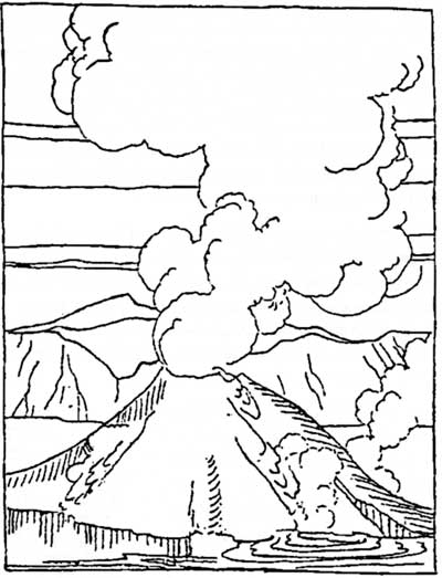
Illustration by L. Howard Crawford, Nature Notes
from Crater Lake, 1934.
Reminders Of Uncertainty
By Steve Mark and Ron Mastrogiuseppe
An earthquake is one of the most unnerving experiences that a person
can have at Crater Lake. Quakes registering magnitudes of 5.9 and 6.0
brought thoughts of Mount Mazama's reawakening to park residents on the
evening of September 20, 1993. This heralded over 2500 aftershocks in
the following three months, most of which could be detected only by
seismograph.
Fortunately the epicenter (or the place where seismographs indicate
the shocks are focused) turned out to be the Mountain Lakes Wilderness
Area, an old caldera located 40 miles due south of Crater Lake. These
tremors did not portend volcanic activity, but are periodic reminders
that Crater Lake sits on the edge of a place where the earth's crust is
expanding. A restless sea of mountains called the Basin and Range is
shoving the great Cascade-Sierra Nevada chain westward.
Characteristics of the Basin and Range
Province
The vast area extending from southcentral Oregon to Utah and
encompassing most of Nevada is testimony to 20 million years or more of
movement. It is called Basin and Range because comparatively flat areas
of drainage alternate with north-south trending mountain ranges. Most of
the basins do not drain to the sea, but one at its western edge does.
Despite that hydrographic anomaly, the Klamath Basin south and east of
Crater Lake National Park is characteristic of the larger Basin and
Range region. Like so many others, the wide basin seen from Rim Village
or Dutton Ridge is defined by mountain ranges running roughly parallel
to each other -- often with one range forming a steep rise, or scarp,
away from the basin.
Earthquakes can occur as the Basin and Range pushes against the
Cascade-Sierran wall. Where the earth's upper crust snaps and breaks,
fracture lines called faults are produced. In this most recent
earthquake, a "normal" fault permitted one side of the fracture to drop
down and pull away from the other. Some northwest- trending faults, so
typical of Basin and Range seismic activity, produced the steep scarps
on the east side of Upper Klamath Lake which can be seen so readily
while traveling on Highway 97 from Crater Lake to Klamath Falls. Like a
ramp which lets one side slip slowly down and slightly away, the plane
of a normal fault is similar to a slanted wall where the top is tilted
away while the bottom is pulled closer to you.
Although the earthquakes of 1993 have been attributed to this type
of activity, the fault responsible is difficult to define. Some
seismographs suggested that the fault skirts Upper Klamath Lake and
Howard Bay, but aftershock epicenters have been placed some distance
away. Since many faults do not reach the surface or may not be vertical,
it is not surprising that the September earthquakes do not appear
related to any known fault.
Earthquakes in the Klamath Basin
Since 1945 at least 12 earthquakes have occurred in the Klamath
Basin. Geologists estimate that the fault zone around Upper Klamath Lake
is capable of generating quakes as large as magnitude 7.25. An army
officer's report from Fort Klamath in 1873 described one earthquake as
severe enough to have knocked people and animals to the ground. Two hard
shocks lasting some five to ten seconds each in this quake broke every
pane of window glass at the fort, but the wooden frame buildings there
appeared to have suffered little damage.
With relatively little property damage resulting, the September
quakes seemed less intense at Fort Klamath than the ones 120 years
earlier. Park structures at Crater Lake seemed unaffected, but Klamath
Falls reported severe damage. As a small village called Linkville in
1873, Klamath Falls had comparatively little experience with quakes of
5.9 and 6.0 magnitude. Some of its brick buildings, being relatively
rigid, appeared susceptible to the shock waves that moved outward from
the epicenters of these earthquakes. Several structures had to be
demolished, adding to the toll of several million dollars in property
losses.
A Volcano's Warning Signs
As much as the Klamath Basin's dramatic landscape has been affected
by earthquakes, most visitors cannot fail to notice the imprint of a
related phenomenon. For the most part, volcanic activity is concentrated
in the same areas as seismic activity. Vulcanism occurs where magma
reaches the earth's surface through a long crack (fissure) or central
vent. An example of the former is Lava Beds National Monument at the
southern end of the Klamath Basin, while the latter is amply
demonstrated by Mount Mazama -- the mountain which holds Crater
Lake.
Volcanic activity can release ejecta (debris which range from large
chunks of lava rock to glowing ash), liquid lava, and gases. Volcanoes
located in the Cascade Range such as Mazama can erupt explosively and
eject lethal particulate matter and/or gasses. Swarms of local
earthquakes, which generally increase in size and number, usually
precede such an event, as they did before Mount St. Helens erupted in
1980.
The September earthquakes did not, of course, follow the pattern
signaling another chapter in Mazama's eruptive history. Nevertheless, it
would be a mistake to assume that the mountain is dead or even dormant.
The long-suspected presence of hydrothermal vents at the bottom of
Crater Lake has been confirmed by researchers who piloted a submarine
there in 1988 and 1989. Water significantly warmer than prevailing lake
temperatures has been found near bacterial mats and features known as
"blue pools" at the bottom of Crater Lake. What it suggests is heat from
the volcano perhaps playing a role in perpetuating what we see from the
surface.
The "Burp" of 1945
Although one might be so bold as to liken present levels of
hydrothermal activity to a pilot light left on low, little is known
about these vents. No clues have surfaced as yet about the so-called
"burp" which occurred almost half a century ago. Bluish-gray clouds of
smoke or gas appeared over the lake several times from September to
December of 1945. Each time visitors and park staff saw these clouds,
the day was calm and clear with no sign of fog or storm conditions. A
cloud would form near the center of Crater Lake, rise sharply, mushroom
out, and finally drift away with the prevailing breezes. By the time
U.S. Geological Survey personnel arrived to monitor the lake with
portable seismographs in January 1946, the strange phenomenon
ceased.
Many people were willing to forget about the "burp" once formation
of the clouds seemed to stop. The park superintendent at the time,
however, noted that a strange disturbance affected several Oregon lakes
in August 1919. Most pronounced was a marked discoloration and the
destruction of more than 1000 fish in Diamond Lake from what observers
took to be an underwater eruption. Newspapers mentioned disturbances of
less intensity in Crater Lake, Upper Klamath Lake, and Marion Lake. An
explanation has eluded geologists, but like the earthquake example, it
is hard to be certain about phenomena of such short duration that occur
underwater and/or underground.
Uncertainty is what drives some people to engage the scientific
method, which is aimed at explaining or interpreting the phenomena
observed. Science depends upon following a logical plan, beginning with
fundamental observations. These are followed by the formulation of
hypotheses so that a plan can be implemented by a way of collecting
information or data for analyses. This method must allow for replication
by other investigators and will determine if the initial hypotheses are
to be accepted or rejected. At all phases, an open mind is required. If
preconceived notions about the phenomenon to be studied affect the
thinking of an investigator to deviate from the method, the effort
becomes unscientific. Good scientific investigations generally yield
more questions than were initially asked.
A Mysterious Buried Log
Radiocarbon dating of organic material such as buried wood is a
valuable tool in attempting to understand the past. Trees destroyed by
Mount Mazama's climactic eruption have been used to ascertain the date
of that cataclysmic event at 7700 years Before Present. So many
carbonized trees have been found in the Crater Lake region that the 7700
year age is the common assumption for all buried logs in or near the
park.
A buried log five and one half feet below the present surface was
discovered in 1984 by Marion Ribble near Spring Creek, southeast of
Crater Lake. Water-saturated buried wood is safe from decay organisms,
and may remain preserved for thousands of years in an oxygen-free
environment. The simple interpretation of the Spring Creek log could
have been that the tree was buried during Mazama's climactic eruption.
After all, this was the story behind a highly-publicized discovery in
1991 northeast of the park, near Chemult. The "Mazama Tree" was found
inside a vertical tree well entombed by a fiery avalanche deposit, and
then covered by a 3 5 foot deposit of airfall pumice. This
well-preserved log did indeed date to Mazama's climactic eruption 7700
years ago.

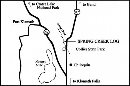
Map showing the location of the Spring Creek
log
The Spring Creek log, however, was buried beneath redeposited ash,
not airfall pumice. What led to the entombment of the Spring Creek log
was not a fiery avalanche
flow, but an event which might have made
Spring Creek or its antecedent a reservoir for log debris. This log is
not carbonized, bearing only surface bark char, displays intact cellular
wood structure, and its widely-spaced tree rings provide evidence for
favorable climactic conditions. These characteristics sparked enough
curiosity to have the log radiocarbon dated. Its age (after calibration
to correct for the difference between radiocarbon and calendar years)
proved to be 7025 years Before Present. This means the tree first grew
approximately 700 years after Mazama's climactic eruption.
The unexpected date for the Spring Creek log raises a number of
questions. Could neighboring cinder cones have produced sufficient
ashfall to create dams to the flow of water and allowed large quantities
of debris to accumulate? Perhaps an oxbow lake of the ancient Williamson
River--which might have predated Spring Creek -- served as a reservoir
for log debris. Once these hypothesized dams broke, large lowland areas
became inundated with deposited debris including buried log
fragments.
At this point a reconstruction of events on Spring Creek is, of
course, only conjecture. But admitting that we do not have all the
pieces to the puzzle is, however, a bedrock of scientific inquiry. We
always live with the possibility that our interpretations based on
limited evidence may be wrong. With this in mind, the next earthquake
should not have to be a reminder that we live in a very complicated and
sometimes inexplicable world.
| 
