|

(click on image for an enlargement in a new window)
FATHER MILLET CROSS
America's Smallest National Monument
By Thor Borresen,
Junior Park Research Technician,
Colonial National Historical Park
Where the mighty Niagara River empties into Lake
Ontario there is a small, projecting piece of land. Its entire area is
approximately 20 acres and yet, to possess 12 of those acres, three
nations fought and battled for more than 100 years --- 1687-1814. Inside
the present enclosure of Old Fort Niagara, which rests on the piece of
land (pictured across these two pages; Web Edition Note: click on
above image for an enlargement of this entire image), is a bronze
cross 18 feet high with an arm of eight feet. On the arm is the
inscription
REGN. VINC. IMP. CHRS.
which stands for "Regnat, Vincit, Imperat, Christus."
The one-eighth acre on which the cross is located (shown by the arrow
and circle in the photograph) constitutes the whole of the national
monument to Father Pierre Millet who, on Good Friday in the year 1688,
reverently blessed the first wooden cross erected to give thanks for the
12 living and immortalize the 88 dead men who had manned the fort during
the preceding winter of starvation. The monument was set aside by
presidential proclamation on September 5, 1925, and the bronze cross was
presented by the New York State Knights of Columbus in 1926.
The Niagara region is world renowned today for its
famous cataract, but its early history is a vigorous, colorful one. The
Iroquois name for Niagara was spelled in several different ways --
"Onguiaahra," "Ongiara" (1), and "Onygara," the latter the most commonly
used by the English. In 1687 "Niagara" began to come into vogue and its
popularity was assured shortly after by Corronelli's map (2), although
as late as 1724, the variation "Jagara" was used on Colden's map (3).
The first white man on record who acquired knowledge of the mighty
cataract was Samuel Champlain, the French explorer who, in 1603,
ascended the St. Lawrence River, then known as the Iroquois or Catarakui
(4). It is generally recognized, however, that he never visited Niagara
River and that the map for which he gathered information in 1603 and
published in France in 1612 (5), showing Lake Ontario and the Niagara
River, was drawn on hearsay of the Indians. When he actually visited
Lake Ontario in 1615, he did so by traveling the length of the Ottawa to
Georgian Bay; at the south end of the bay he made portage over to Lake
Simcoe and from there overland until he struck the River Trent, which he
followed to its mouth in the Bay of Quinte; then, following that bay to
the Upper Gap, he crossed Lake Ontario to what is known today as Mexico
Bay (6). The map of his travels in 1615 was not published until 1632,
and while it shows a slight change in the river's position from his map
of 1603, neither the falls nor the river are placed correctly (7). Up to
1640 only traders and missionaries had seen the river and no attempts to
inhabit the area had been made by white men.

|
From the earliest descriptions by both red men and
white, the plateau where the present Old Fort Niagara and the cross are
situated was devoid of trees. The Indians used it for centuries as a
camping and meeting place and during those years all growth undoubtedly
was sacrificed for camp fires. A clearer understanding of the important
part the region played in the travels of the Indians may be gained by an
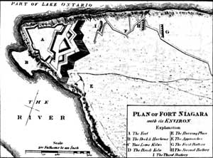
examination of the map at the bottom of this page (Web Edition Note:
at left) (8). The Indians coming from the upper lakes followed the
Niagara River from Lake Erie to below what is now Buckhorn Island in the
upper Niagara, or the La Salle section of Niagara Falls, New York.
(There is today a four-lane highway over this route which has been known
for years as the Military Road.) They again placed their canoes in the
Niagara slightly below the point where now is situated the Lewiston and
Queenston suspension bridge. From there they followed the lower Niagara
to its mouth where it enters Lake Ontario, seven miles below Lewiston,
New York. At "B" on Captain Pouchot's map (below) is shown a piece of
land projecting into the river. It is only from three to five feet above
the flow of the stream and was an ideal place for hauling out canoes.
The plateau (see A) where the fort stands is 23 to 26 feet above the
lake level and afforded an excellent stopover when storms did not permit
the frail Indian boats to enter the lake.

|
The first white man known to begin construction on
the site was René Robert Cavelier, more famous as the Sieur de la
Salle. On May 12, 1678, he had been granted by the King of France (9) a
patent to trade with the Indians. This trade was to be limited, however,
to the western and southern tribes that could not reach Montreal and
Quebec with their stock of furs. The Ottawa River, having numerous
portages, was not a suitable waterway for La Salle's scheme of
large-scale trade, but the Niagara was ideal for it permitted large
vessels to go all the way from Fort Frontenac (Kingston, Canada) to
Lewiston. At the latter post he placed a magazine, with another at La
Salle, New York, in the upper Niagara, where he built the
Griffin, the first sailing vessel on Lake Erie, estimated by
various historians at 40 to 60 tons. The seven miles between the upper
and lower magazines was the only portage from the Great Lakes to
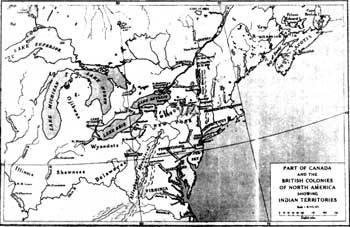
Montreal. For this reason the Niagara River has been called the "Gateway
to the West" [See map at right] (10).
La Salle realized, as the Indians did, the value of
the small harbor at the mouth of the river. To make it secure he
constructed a small fort where the present Old Fort Niagara stands. It
consisted of two 40-foot-square redoubts and one magazine, all
constructed of logs laid horizontally one on the other, the whole joined
by palisades. It was called Fort Conti in honor of Prince Conti, a
member of an old Italian family who had recommended Henri Tonty to La
Salle. Tonty was one of La Salle's staunchest supporters throughout his
entire exploratory career. The fort was completed sometime in the early
spring of 1679 but was burned later in the year through the carelessness
of a sergeant in charge of the garrison. La Salle did not rebuild the
storehouses and stockades, and it was not until the summer of 1687 that
the place was fortified again by the French.
The Iroquois had tolerated La Salle, but they were by
no means tolerant of the French explorers and traders in general; they
did not heed the peace treaty signed by the French and English at
Whitehall on November 26, 1686, an agreement which did not establish any
defined borders between the two nations' holdings, or prevent either
country from warring on any of the native tribes. Denonville, Governor
of Canada, claimed as part of French colonial possessions all the lands
bordering the Great Lakes and those along the Ohio and Mississippi
Rivers as far as Louisiana. The main trade route to these possessions
was by way of Lake Ontario and Lake Erie, with the portage at Niagara.
Among the most troublesome Indians along the route were the Senecas, the
leading tribe of the Iroquois Confederacy, whose territory bordered the
lakes of Ontario and Erie.
Denonville decided in 1687 to destroy the Senecas'
power and to bring them definitely under French domination. On June 13
he left Montreal with 800 troops. The number had increased to nearly
2,000 by the time he reached Fort Frontenac, where he remained until
July 4 when he left with a flotilla of more than 400 canoes for
Irondequoit Bay (Baye des Sables) (11). The Indians themselves destroyed
their villages at the approach of the French, leaving the enemy the
satisfaction of damaging only the gardens and food supplies. They
escaped actual annihilation by keeping out of the Frenchmen's way. On
July 24 Denonville returned to his place of embarkation, leaving there
for Niagara. Determined to retain a foothold in the Seneca country, he
began construction of a fort on the same site on which La Salle's
defenses had stood nine years before. According to the journal of De
Tregay, lieutenant of the garrison and its surviving commander, Madame
Denonville accompanied her husband on the entire journey. If she did so,
she was the first white woman whose presence on the Niagara is recorded.
One of the officers with Denonville's expedition, Baron de la Hontan,
describes the work as a "fort of pales, with four bastions," which
"stands on the south side of the Straits of Herrie [Erie] Lake, upon a
Hill, at the foot of which that Lake falls into the Lake of Frontenac
[Ontario]."
When Denonville left Niagara, he promised supplies
would be sent back to the 100-man garrison immediately upon his arrival
in Montreal. As the season advanced and no supplies arrived, the
garrison was in a dangerous situation. The Indians had not been subdued,
and no help could be expected from them. On the other hand, they
ambuscaded and tried to destroy the French whenever they ventured out to
hunt or gather wood for their fires. Chevalier de Tregay tells in his
journal of the futile attempts by the men to take fish from the lake.
The garrison was on the verge of starvation when the barque arrived with
provisions. It was not until the sails of the ship were disappearing
against the horizon on its return to Kingston that the men became aware
of the condition of the supplies. They were all spoiled, unfit to eat.
De Tregay tells of the ruined provisions and how the garrison faced
winter with no food fit for human consumption. With hostile Indians on
one side and water on the other, their fort was more a prison than a
protection. Scurvy and starvation soon took their toll. De Tregay
continues:
The wood choppers, one day, facing a storm, fell in
the drifts just outside the gate; none durst go out to them. The second
day the wolves found them - and we saw it all (12).
By the end of February 60 had died. One morning De
Tregay heard Commander de Troyes mumbling names of loved ones. Soon
after he joined the major portion of the garrison. De Tregay himself was
on the verge of succumbing to starvation when, suddenly, a huge savage
in full war regalia appeared before him. Too weak to offer resistance,
he prepared himself for the inevitable, but instead the Indian held
before him food, and in the language of the Miamis said "Eat!". So it
was that a few friendly Miamis Indians from the Ohio Valley rescued the
12 survivors of the garrison of Fort Denonville which had consisted
originally of 100 men.
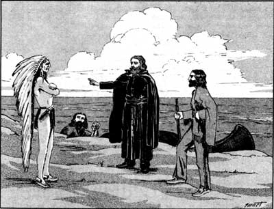
It was on Good Friday, 1688, that Father Millet, a
pioneer missionary who went to Canada in 1667 from his native France,
directed the garrison survivors to plant a huge cross in the center of
the square forming Fort Denonville to commemorate the men who had died
and give thanks for those who had survived. The dimensions of the cross
and its inscription were the same as those mentioned above in a
description of the permanent bronze substitute erected on the site in
1926.
Pierre Millet, born in 1635 at Bourges, the
approximate geographical center of France, was educated for the church
and, when 32 years old, sailed for Canada as one of the early priests
whose heroic devotion took Christianity into America's virgin
wilderness. "He served about 15 years as a missionary among the Onondaga
and Oneida Indians within what is now the State of New York," said the
presidential proclamation which established the national monument, "and
subsequently became a chaplain in the French colonial forces." He died
in Quebec.
During the summer of 1688 another peace treaty was
signed between England and France, as well as an agreement between the
Iroquois and the French to stop further violence on the frontier. In
this agreement the French consented to the withdrawal of their forces
from the Niagara region and to the destruction of the fort except for
the cabins and quarters, which were to be left standing for the use of
the Indians. The itemized list of buildings left by the French helps to
picture what this ancient fort looked like:
"ITEM, A cabin in which the Commandant loged,
containing a good chimney, a door and two windows furnished with their
hinges, fastenings and locks, which cabin is covered with forty-four
deal boards, and about six other boards arranged inside into a sort of
bedstead.
"ITEM, In the immediate vicinity of said cabin is
another cabin with two rooms having each its chimney; ceiled with
boards, and in each a little window and three bedsteads, the door
furnished with its hinges and fastenings; the said cabin is covered with
fifty deal boards and there are sixty like boards on each side.
"ITEM, Right in front is Rev. Father Millett's cabin
furnished with its chimney, windows and sashes; with shelves, a bedstead
and four boards arranged inside, with the door furnished with its
fastenings and hinges, the which is of twenty-four boards.
"ITEM, Another cabin opposite the cross, in which
there is a chimney, board ceiling, three bedsteads, covered with
forty-two boards, with three like boards on one side of said cabin,
there is a window with its sash and a door furnished with its hinges and
fastenings.
"ITEM, Mother cabin with a chimney, a small window
with a sash and door; covered with thirty deal boards; there are three
bedsteads inside.
"ITEM, A bakehouse furnished with its oven and
chimney partly covered with boards and the remainder with hurdles and
clay; also an apartment at the end of said bakery containing two
chimneys; there are in said bakery a window and door furnished with its
hinges and fastenings.
"ITEM, Another large and extensive frame building
having a double door with nails, hinges and fastenings, with three small
windows; the said apartment is without a chimney; 'tis floored with
twelve plank (Madriers) and about twelve boards are arranged inside;
without, 'tis clap-boarded with eighty-two plank.
"ITEM, A large storehouse covered with one hundred
and thirty boards, surrounded by pillars eight feet high, in which there
are many pieces of wood serving as small joists, and partly floored with
several unequal plank. There is a window and a sliding sash.
"ITEM, Above the scarp of the ditch a well with its
cover."(13).
The story of the present Old Fort Niagara does not
begin until about 1725, and is one to be told another time. The writer
of this article was a member of the staff during the restoration of Old
Fort Niagara, from 1926 to 1934, and had charge of several minor
archeological excavations. During this work skeletal remains were
encountered. Some of the burials were only 11 inches below the surface
and changes in the road system necessitated the removal of a few of
them. What portion of these represents the period of starvation, no one
has determined. During the French and English war, when General Pridaux
laid siege to Fort Niagara in July, 1759, many of the French of the
garrison were killed and buried within these walls; and during the War
of 1812, several casualties occurred, their internment most likely
taking place on the spot.
During the summer of 1934, a large monument was
erected within the grounds to commemorate the Rush-Bagot Treaty of 1817
between Canada and the United States. A suitable niche was constructed
in the center of this memorial and all the remains, sealed in an
aluminum container, were placed there, the whole marked with an
inscribed stone.

(1) Justin Winsor, editor, Narrative and
Critical History of America (Boston [copyright, James R. Osgood and
Company, 1884]), IV, 247.
(2) Justin Winsor, Cartier to Frontenac:
Geographical Discovery in the Interior of North America in its
Historical Relations, 1534-1700 (Boston, 1894), 334.
(3) Justin Winsor, editor, Narrative sad Critical
History of America (Boston, 1887), V, 491.
(4) Justin Winsor, Cartier to Frontenac,
op. cit., map, "A Plan of the Fort and Day of Frontenac with
adjacent Countries," [published in the London Magazine in 1758],
335.
(5) Edward T. Williams, A Short History of Old
Fort Niagara (published by Old Fort Niagara Association, Inc.,
1929), 11; westerly portion of map reproduced in Winsor's Narrative
and Critical History, op. cit., IV, 381.
(6) Justin Winsor, editor, Narrative and Critical
History of America, op. cit., IV, 125-126; "Champlain's
Route, 1615," map on p. 125.
(7) Easterly and westerly portions of Champlain's
1632 map reproduced in Winsor's Narrative and Critical History,
op. cit., IV, 386-387.
(8) Photocopy of map, "Plan of Fort Niagara with its
Environ," by Pouchot, 1759; taken from Memoir upon the Late War in
North America, Between the French and English, 1755-1760, by Pouchot
([translated and edited by Franklin B. Hough], Roxbury, Mass., 1886),
II, 152.
(9) Justin Winsor, Cartier to Frontenac,
op. cit., 256.
(10) Photocopy of map, "Part of Canada and the
British Colonies of North America showing Indian Territories," from
The Faithful Mohawks by John Wolfe Lydekker (New York, 1938), ff.
206.
(11) Pouchot, op. cit., II, 124.
(12) Williams, op. cit., 24.
(13) Ibid., 25-26.
|

