|
PARTNERSHIP AT JAMESTOWN
Archeology and History Work Hand in Hand
BY J. O. HARRJNGTON,
ASSOCIATE ARCHEOLOGIST,
COLONIAL NATIONAL HISTORICAL PARK, VIRGINIA.
One of the most universal characteristics of the
human race is an interest in the past. This is attested by the fact that
in the most primitive human groups myths and legends telling of the
origin of the earth and of the first human ancestors of the group exist
and are cherished from generation to generation. With the birth of
civilization, speculation gave way to study, and history was born---the
recounting of and explaining of the incidents in the life of a nation
and the world.
In recent years, as history has become studied
generally, people have taken an interest in the places associated with
the great men and events in the past of their nation. One important
outcome of this interest has been the establishment by the National Park
Service of the many historical parks and monuments. Jamestown Island,
the site of the first permanent English settlement in America, long has
been significant to Americans, and a part of it was logically acquired
and set aside by the Service for study, development, and
preservation.1 But at Jamestown it was obvious that the
conventional historical approach could not tell the entire story. Too
many of the records had been lost or destroyed; and too much of the
story never had been committed to writing in the first place. So a
different research method---archeology--- was called upon.

|
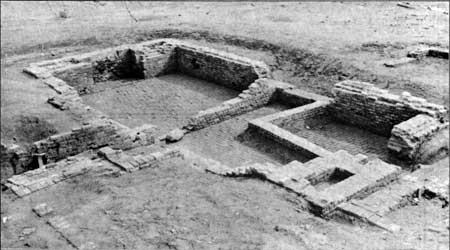
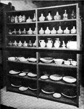
| Above is shown one of the many house
foundations which have been uncovered on Jamestown Island. Below: Some
of the glass bottles and pottery objects after their restoration in the
archeological laboratory.
|

|
Archeology is a relatively new science. Since the
beginning of the study of history, historians have run against an almost
impassable barrier, the barrier that stands where writing or recording
in some way first was developed. What had not been put on stone, clay,
papyrus, or paper could not be learned; and the early students of the
past could only guess at the meanings of the remains which we now know
to have been left by prehistoric peoples. But within the last 100 years
archeology has been pushing through that barrier. From soil strata and
potsherds, ruined buildings and cemeteries, archeologists have
reconstructed the story of the past so that today the school child who
begins the study of world history starts far back of the first written
records.
As archeology has developed it has shown that the
barrier of written records stands not only at a point in time, but also
at a point in culture. In other words, there has never been a time or
place when society had written down everything that happened to it. For
instance, Roman archeology has supplemented Roman history, not only in
the period before Romans started recording their history, but likewise
within the historic period, by supplying data concerning the development
of art and architecture and the details of domestic life of the time
which the Romans did not take the trouble to record.
In spite of the fact that history and archeology are
related so closely and are working to the same end, revealing and
explaining the facts of the past of the human race, they have not always
come together and applied their techniques consciously and
simultaneously to a specific problem. Within each field there is a
fairly well defined feeling that certain problems and periods belong to
the historian and certain others to the archeologist. At Jamestown,
however, the problem is being approached differently. Here historical
research and archeological research are working hand in hand to recover
the story of the years from 1607 to 1699, the period in which Jamestown
was the leading community of the colony of Virginia. The logic of the
program is readily apparent. Records of this first century of English
colonization of America are meagre when compared to those of later
periods. The early settlers were too busy wresting a living from the
wilderness to spend much time in recording their adventures for the
edification and entertainment of posterity. Of the records that were
made, only a part are available, many having been destroyed or lost.
Moreover, even as today, people seldom left permanent descriptions of
their houses, their furniture, and the dishes from which they ate. Many
of these missing facts now can be supplied by archeological
investigation.
Although the work is known as the Jamestown
archeological project and the problem is being approached primarily as
an archeological one, documentary research has an important place in the
program. A map, a deed, or possibly even a brief court record may be of
greater value in determining facts about a building than would a
season's excavating. The important thing is that the historian and the
archeologist are working together, planning their research with specific
problems in mind, and using the results of both kinds of research to
further the uncovering of the story. As each single tract or building is
considered for study, preliminary historical research is carried out as
the first step. These documentary data serve as a guide for directing
the course of the excavations and a key for interpreting the
archeological remains. As results accrue from the excavating, certain of
the documentary data take on new meanings which, in turn, provide more
intelligent direction for further archeological research. There is
accumulating, by this process, an ever-expanding body of knowledge made
possible by the combined activities of several fields of specialization.
This can be illustrated by a brief review of one fairly simple example
of research.
It long had been noted and had become a matter of
concern to persons interested in the preservation of historic sites that
Jamestown Island was being washed away rapidly by the waters of the
James River. Early in the present century, through the efforts of the
Association for the Preservation of Virginia Antiquities, a substantial
shore protection was constructed at the upper end of the island by the
United States Army, and in recent years the National Park Service has
continued the sea wall along the entire limits of the old town. Numerous
historians have pondered over the amount of destruction that had taken
place. An old cypress tree, standing today some 260 feet from the shore,
marks the position of the shoreline at one period, but there has been no
documentary evidence which, alone, would locate exactly the extent of
the land during the seventeenth century.
For a number of reasons, and particularly to aid in
locating and identifying land features and early buildings, it is
important that the position of the seventeenth century shoreline be
known. Colonel Samuel H. Yonge estimated that at the western tip of the
island there had been a recession of 482 feet, based on an assumed
annual rate of two feet a year until 1860 and four feet a year
thereafter.2 Such an estimate, although later proved to be
accurate, was not satisfactory for the purpose of locating exactly the
property lines and other early remains. It was up to the archeologist to
try his hand.

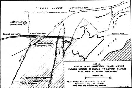
(click on image for an enlargement in a new window) Naturally there was no hope that any sort of evidence
could be found beyond the present shore because the currents and tides
would have destroyed or shifted even the most substantial remains. But
the archeological excavations made during the summer of 1939 did provide
evidence which permits the locating of a considerable portion of the old
shoreline. A patent to William Sherwood, dated April 20, 1681, reads in
part:
. . . beginning at James River at the head of a great
slash Issuing into the back River and down the sd slash East 1-2
a point Southerly Eighteene Chaines thence North 3/4 point Easterly
fower Chaines to the back River Marsh and up the same to a Markt
persimon tree under blockhouse hill point thence under the said Hill
West six Chaines to James River and downs it againe to the first
Mencon'd slash including eight acres & thence againe down the said
slash forty three Chaines to Mr Richard James Land and along it
South twenty three Chaines to a branch of Pitch & Tarr swamp thence
up the said branch to James River and Up the River to the place it
begun. . .3
This document, although of considerable value, would
have been of little help within itself unless certain of the landmarks
mentioned could be located and identified beyond question. Fortunately,
however, there is preserved among the Ambler Papers in the Library of
Congress a copy of a survey which Sherwood had made for this piece of
land.4 Shown on this survey plat is the old road leading from
Jamestown to the mainland. Also indicated are the adjacent marshes and
the shore of the river. It was found, by fitting this tract to the
present topography, that the marshes could be made to coincide with the
present ones, but corroborative evidence of a more specific character
was desired.
Exploratory trenches were excavated across this area
from the present shoreline to a distance well beyond the probable
eastern extent of the tract. In so doing, the remains of an old, much
used road were found. They were followed for 140 feet, a distance
sufficient to determine the direction. Then again placing the Sherwood
plat on the map of today, but making the roads coincide, it was found
that the east line of the property coincided exactly with an indistinct
line of dark areas which had been recorded as remains of trees or a
hedgerow. By locating the Sherwood tract to conform with the position of
the road and the property line, it was found that the outlines of the
marshes coincided almost exactly with those shown on the survey plat and
established that there has been little change in the topography of this
section of the island with exception of erosion by the river. The map
reproduced on the preceding page shows both the present-day topography,
including the road and property line found in the excavating, and the
features recorded on the survey plat; and there now can be located, with
considerable assurance, the position of the old shoreline for a distance
of more than 2,000 feet.5
This example serves to illustrate the manner in which
archeological and documentary research work together, each
supplementing, interpreting, and verifying the facts brought to light by
the other. Although many more instances could be cited, much less simple
than the one described here, the general problem and method of approach
have been indicated. By such research, under the combined studies of
historian, archeologist, museum specialist, and architect, considerable
knowledge has been gained concerning Jamestown during the seventeenth
century. The exact extent of the town has been determined, the location
of various tracts of land has been ascertained to with in a few feet,
and roads, fences, wells, bridges, orchards, ditches, and a large number
of buildings have been located and identified as to age and ownership.
Moreover, by combining the information from the excavating and from
documentary research, knowledge is accumulating as to the architecture
of the seventeenth century and the tools and objects in use by the
colonists during that period.
These results, valuable though they may be in the
future interpretative development of Jamestown, are possibly no more
important than the far-reaching effects of this relatively new approach
to the study of historic sites. The demonstration that a great quantity
of historical knowledge can be obtained by careful, painstaking
archeological research, no matter how recent the site, may be the most
significant contribution of the work at Jamestown.
1An important portion of the site of
Jamestown, which included the single standing seventeenth-century ruin,
the old brick church tower, was acquired in 1893 by the Association for
the Preservation of Virginia Antiquities. This organization, in keeping
with its policy of preserving significant historic sites, has developed
and safeguarded that part of the area with characteristic energy and
wisdom. The remainder was acquired by the United States government in
1934 as a unit of Colonial National Historical Park. The agreement just
made between the Association and the National Park service, concerning
cooperative investigation, development, and preservation of the
Jamestown treasures, is described on page 7.
2The Site of Old "James Towne"
1607-1698 (Richmond, 1926), 25-26.
3Ambler Papers, No. 31, Library of
Congress.
4Ibid., No. 134.
5The portion of the Sherwood survey plat
shown on page 4 was enlarged to exactly the same as that of the
present-day map.
Agreement Unifies Jamestown
Program
An outstanding example of the potentialities for
cooperation resulting from enactment of the Historic Sites Act of 1935
was the agreement reached September 20 between the Association for the
Preservation of Virginia Antiquities and the National Park Service. The
understanding, which was announced by Mrs. Arthur P. Wilmer, president
of the Virginia organization, provides for a unified program of
development and administration for the entire Jamestown Island area, a
part of which is in federal ownership while another portion, including
the sole remaining ruin, belongs to the Association.
The agreement, an outgrowth of some 18 months of
mutual study, also authorizes the Service to conduct archeological
investigations in selected sites; and it assigns, in any museum that the
Service may build, special galleries for the preservation and display of
Association-owned historical objects uncovered by the explorations.
"The agreement as to trenching the island will make
it possible to decide certain moot historical questions regarding which
historians have differed for many years," said Mrs. Wilmer. "The
location of many important sites on the island, where English
civilization was first planted on American soil, has been a subject of
controversy for some years, and archeological trenching will enable
historians to study the historic end of Jamestown Island, which the
Association owns."

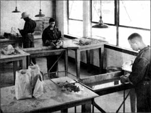
Civilian Conservation Corps Enrollees Washing and Sorting
Artifacts in the Jamestown Archeological Laboratory.
|
The A. P. V. A. acquired its preservation holdings at
Jamestown when the island faced destruction from the erosional action of
the James River. The Association's noteworthy program of conservation
and development was continued over a number of years and the need for
further exploration was recognized, but, explained Mrs. Wilmer, it
"would have been impossible for the A. P. V. A. with its small personnel
and limited capital, as would the erection of an adequate, fireproof
museum in which to house and display the interesting objects uncovered
by these investigations. Many important artifacts unquestionably will be
found on this end of the island, which has had virtually no
archeological investigations before this time."
The committee on cooperation with the National Park
Service, which studied the unified preservation and development program
for Jamestown, was composed of Miss Ellen Harvie Smith, chairman;
Herbert Claiborne, Granville G. Valentine, Miss Elizabeth Watkins, and
Mrs. Hampden Chamberlayne. Murray M. McGuire was legal adviser, and Dr.
Fiske Kimball, a member of the Service's Advisory Board on National
Parks, Historic Sites, Buildings, and Monuments, was designated general
adviser.
|

