PALISADED
TOWN
BY CHARLES H. FAIRBANKS,
JUNIOR ARCHAEOLOGIST,
OCMULGEE NATIONAL
MONUMENT, GEORGIA.
|
 |
Four hundred years ago the wooded valley of a winding
stream, now called the Ocmulgee River, echoed the tread of warhorse and
soldier and the dull crack of the arquebus. These discordant sounds
belonged not to the native Indian but signaled the advance of Hernando
de Soto and his soldiers in search of a new land filled with glory and
gold. The Spaniards never reached the Old Ocmulgee Fields which now
comprise Ocmulgee National Monument. They did, however, visit Indian
towns a few days' journey down-river, thus giving the modern student his
first written record of that past. These Indians we now call Lamar,
because the plantation of that name was one of their principal villages.
They spoke the Muskogean language and had but recently come into central
Georgia conquering and driving out the earlier tribes. Their conquest
was not an easy one, however, and we find that their larger towns were
carefully defended against attack. These defenses have recently been
explored at the Lamar tract and it is now possible to draw an accurate
picture of them.
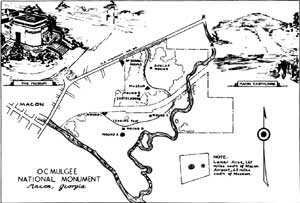
(click on map for an enlargement in a new window)
|
The Lamar Indians first chose, as the site for their
village, a secluded spot in the Ocmulgee valley. The river valley was
much wetter than now. The Ocmulgee River has deposited two or three feet
of silt in this region since the forests were cut, thus raising the
level of the entire area. The place the Indians picked was a hammock of
higher ground in the swamp. This siland or knob, itself fairly dry, was
completely surrounded by sloughs and dank bogs. Travel through these
swamps today is extremely difficult, except during dry weather. Four
hundred years ago travel must have been almost impossible.
At the present the swamps are inhabited by a large
and bloodthirsty tribe of mosquitoes. They certainly did not make the
Lamar village a pleasant place to live. The Indian, with a protective
coat of grease, probably got along with a minimum of slapping and
scratching. His practice of keeping the household fire burning from one
New Year's Dance to the next may have helped to drive off mosquitoes and
gnats.
In addition to the encircling swamps the town was
provided with a man-made defense. This consisted of a palisade and ditch
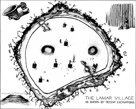
completely surrounding the village. The first drawing shows a modern
artist's conception of this town. The palisade was arranged in a half
circle around the two mounds and the residences of the village. It
completely enclosed an area of about 25 acres. This semicircular form
was necessary because of the shape of the "island" on which it was
built. Their first palisade enclosed a comparatively small area which
soon proved too restricted for the village. Then the second line was
built which enclosed nearly all of the available land higher than the
swamp.
To modern soldiers the palisade would not appear to
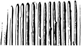
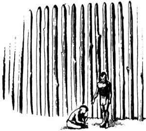
be of much value in defense. It was made of logs about eight inches
thick and twelve to fifteen feet long. These were firmly set in the
tough red clay to a depth of about 18 inches, the posts were placed
about one foot apart, this resulting in an open or "picket" type of
fence about 12 feet high. This palisade was not a curtain or screen to
stop arrows, but an obstacle to stop the charging enemy. Outside the
stockade was a large open ditch which followed the edge of the island
and connected with the swamps. This ditch, partly filled with water and
muck, was an additional barricade. Georgia red clay, when wet, is a good
obstruction. On some sides, perhaps were attacks had occurred
frequently, extra lines of posts were put up to reinforce or screen the
main line. Entrances were likewise protected by an outer line of posts,
as the Indian had no use for a gate in such a palisade. He constructed
the entrance by curving one line outside the other. One early writer
described this as resembling the coil of a snail shell. It is probable
that small watch towers guarded the entrance. Only one entrance, on the
north side, has been found at the Lamar Site. There the outer line of
posts forming the entrance disappears into the swamp muck. It is
possible that this indicates that travel through the swamps was by
canoe. That would seem to be the most pleasant way to travel but we do
not know exactly how much water there was in the swamps at that
time.
(click on image for an enlargement in a new window)
At the northwest side of the palisaded town there
were two large pits, each more than fifty feet in diameter and at least
five feet deep. One lay outside the palisade, the other inside. These
pits were kept partly filled with water as the bluish muck in the
bottoms clearly shows. Also there was an additional pair of pits at the
southeast side. The simplest explanation for these pits is that they
were water reservoirs for use during attack. This may well have been
their original use, but one of De Soto's soldiers says that such pits
were fish ponds. Fish in large numbers were caught in the spring by
various methods. A favorite method was to stun the fish with a poison
made from the roots of the Dwark Buckeye. Those fish not immediately
eaten were placed in the fish ponds to be used when needed. Many kinds
of fish found in the region will live for long periods in such small
ponds. The Lamar Indians were not very particular about the sanitation
of their ponds as large quantities of refuse were found in the pits.
From digging, the archaeologist is able to
reconstruct a picture of life in the past. We see a central town of fair
size with two temple mounds and many residences. It was built on an
"island" of higher ground surrounded by miasmic swamps. Insufficient
natural protection caused, or led, the Indians to build a palisade with
a maze-like entrance. Outside of that a ditch, partly filled with water,
connected with the deep swamps. As the village grew in size the palisade
was placed farther out till it bordered the swamp. Convenient ponds were
provided for the storage of water and fish. The field, of corn, beans,
and squash occupied nearby hammocks in the swamp. Travel may have, been
by canoe or by foot, following the winding trails through the bogs. Such
a place to live could not have been chosen because it was attractive and
must have been dictated by military necessity.
It was during this period that the Muskogean invaders
of Georgia developed their native empire that eventually became the
Creek Confederacy led by Emperor Brims. They were not purely defensive,
however, as they successfully conquered and absorbed many of the earlier
tribes.
The Indian method of fighting was based on small
parties, surprise and short hand-to-hand combat. The swamps, with the
ditch and palisade, prevented real surprises. The palisade, while
allowing entrance for daily purposes, gave the defenders some advantage.
Close combat usually goes to the party with some defenses, however poor.
The palisade probably gave the Lamar people a real sense of security but
certainly did not lull them into a false sense of safety.
While the archaeologist can deduce all these things
from holes in the ground and from differences in the color of the soil,
he must depend on written records to breathe life into his pictures.
These written records do not come from the Indian but from early
travelers in the South. As mentioned earlier, we have the soldiers of De
Soto to thank for one description of the Indian towns and fish ponds.
Other writers, soldiers, botanists, and missionaries left descriptions
of Indian towns, but one man especially helps us. That was the
Frenchman, Jacques le Moyne, a painter of considerable skill, who
accompanied the expedition of Laudonnier to the Georgia and Florida
Coasts in 1565. This party was to reinforce the Huguenot settlements
already threatened by the Spanish. Le Moyne was supposed to map the
rivers and paint whatever there was of interest. He was inclined to
exaggerate the size of alligators and other strange animals but his
drawings show a real ability and a keen perception. The French were
disastrously defeated by the Spanish from St. Augustine but le Moyne
escaped and returned to France. His paintings were not published until
after his death when de Bry issued them, with a Latin text, at Frankfort
en-Maine in 1591. As they were drawn in 1565 they represent the coasts
of Georgia and Florida during the period of the Lamar Indians.
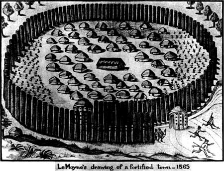
The first picture shows a fortified village of the
period. Le Moyne gave us the following description of their
fortifications.
"The Indians are accustomed to build their towns in
this manner. Some place is chosen near which a swift stream flows. They
level the place as much as they are able. Then they dig a furrow laid
out in a circle. Thick round poles of twice a man's height are placed
close together around the town (in this furrow) which is carried past
the entrance like a snail shell (spiral) so that a narrow entrance is
formed. No more than two abreast or together could be admitted. The
channel of the stream is also lead to this entrance. To each entrance
head it is the custom to erect a small round building, each one full of
loop-holes and slots. These houses are well made, considering their
means. In these are stationed as sentinels men who can detect the enemy
a long ways off; and who, as soon as they discover the enemy pursue them
and raise a loud cry, which is heard by the inhabitants of the town.
These rush to the defense armed with bows, arrows and clubs. In the
center of the town they place the kings house, sunk a little below
ground to avoid the sun's mid day rays. Circling this the houses of the
nobles."
This is a free translation of the Latin text of the
original and fairly well describes the type of fortified town found at
Lamar. Those coastal Indians had no mounds but the ditch and palisade
were described. They were probably closely related to the Indians of
central Georgia and le Moyne's drawing reveals to us a great deal about
the remains we have uncovered.
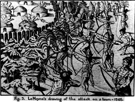
The second Le Moyne drawing shown illustrates an
attack on a palisaded town. Arrows with burning Spanish moss attached
are being used to fire the dry thatch of the houses. Little actual
combat is shown and the Frenchmen were surprised at the brevity of
Indian battles. In connection with this sketch it is interesting that
several burned houses were found at Lamar. The attack was only partly
successful and a later picture shows some houses still burning while the
Indians sadly bury their chief with appropriate ceremonies.
The Lamar site is being systematically excavated. In
the future it will be possible to restore the palisade and the houses.
In that restoration the work of the archaeologist and the early painter
Jacques le Moyne will be combined to recreate the village of an Indian
tribe who lived on the banks of the Ocmulgee when De Soto invaded
Georgia four hundred years ago.
|

