|
HISTORIC HIGHWAY BRIDGES OF OREGON
|

|

St. John's Bridge (1931), Willamette River, Portland, Multnomah County
APPENDIX A
GUIDE TO THE BRIDGE PHOTO-DESCRIPTION PAGES
Bridge Photo:
The bridge photographs, with only two exceptions, are
current views taken in conjunction with the historic bridges study. The
exceptions are the photographs of the Yaquina Bay (Newport) Bridge,
taken about 1975, and the Oswego Creek Bridge, 1980.
Bridge Name:
Bridges are frequently identified by several names.
In an attempt to minimize the confusion, a standardized naming approach
was used in the study. The bridge is formally named for the waterway or
other feature it crosses, with appropriate other common names in
parenthesis. In addition to the waterway crossed, bridges are sometimes
named for their locality, geographic features, roadway or street
carried, pioneer families, important persons, and so on. Viaducts and
over/undercrossings usually carry the name of the roadway, but some are
also named for the locality. (Note: the index at the end of the document
cross-references all of the names of each bridge.)
Structure Number:
This identification is usually the number assigned to
the bridge by the ODOT and is not necessarily the number used by the
cities or counties. Some bridges are unnumbered, and for others, the
numbers are unknown.
Roadway:
The state highway, county road, or city street
carried by the bridge is shown on this line. The milepoint (M.P.) of the
bridge is indicated on state highways and other highways and roads where
known. The state highway numbers used in this document are not the
familiar state or national route designation. The state highway numbers
used in this document are shown on the following pages.
Location:
This reference indicates the city, community, or
vicinity location of the bridge, followed by the county. Some bridges
connect two cities, counties, and/or states, and this is so indicated.
(Refer to the location information in Appendix C.)
Construction Date:
The construction date refers to the year when the
bridge was fully completed and opened to service. (This date may not
always agree with bridge plaques or other bridge records which show
dedication dates or the major year when construction was underway.)
Material and Type:
The basic material and structural type of the main or
center span are indicated in this area. Specific truss types, if
appropriate, are included in parenthesis. (Refer to Appendix D.)
Ownership:
The owner is shown on this line. Unless otherwise
indicated, the "State of Oregon" refers to structures under the
ownership and maintenance authority of the Oregon Department of
Transportation.
Narrative:
A short narrative provides descriptive information
about the bridge, its history, and significance.
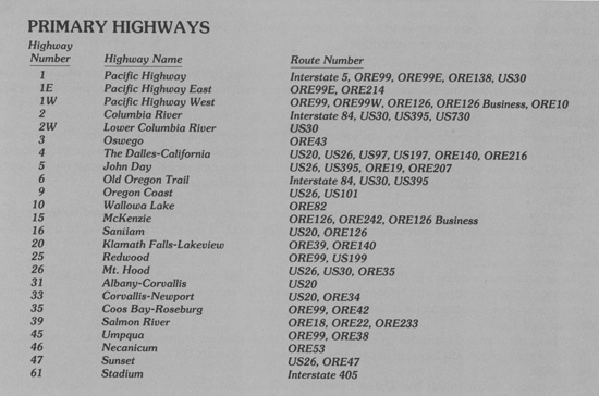
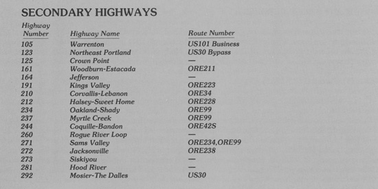
STATE HIGHWAY NUMBERS
The highway numbers on the photo-description pages are those used by the Oregon Department of Transportation and are not the state or federal route numbers, commonly recognized by the public. The guide below shows the highway numbers, highway names and route numbers. Highway route numbers may traverse the highways in entirety or only in part. A route common with another for less than one mile is not shown. All of the state highways are not listed, only those mentioned in this report.

|

|
| <<< Previous | <<< Contents>>> | Next >>> |
appa.htm
Last Updated: 06-Aug-2008